Search Results

Keyword: ‘land use ridership model’

Estimating the Impact of the US Citizenship and Immigration Facility on Metrorail

February 24th, 2016 Comments off

The Federal Government is the region’s single largest employer, and where it chooses to locate its jobs has huge implications for ridership, revenue, and the local operating subsidy.

We recently detailed why the Federal government’s location decisions matter so much to Metro – and you, the taxpayers who help support WMATA through your local taxes.  We’re always keeping an eye on moves within the region and certainly hopeful that any major moves (whether they are in the public sector or private sector) locate near Metrorail.  That’s because locating near Metrorail increases ridership, increases farebox revenue, and lowers the (your) taxpayer burden to support Metro.

Naturally, the news about GSA’s upcoming decision on the location of the US Citizenship and Immigration Services complex (USCIS) caught our eye and wonkiness.  We wanted to know about how much ridership and revenue the different options might generate.

US-Citizenship-and-Immigration-790x320

Read more…

First Things First

December 14th, 2015 2 comments

Secretary Foxx has issued his direction that Metro cannot consider any new rail expansion right now, and WMATA agrees!  So much so that we wrote it into our strategic plan back in 2013.  Earlier this fall, the Prince William County’s Board of Supervisors heard from WMATA about the importance of fixing Metro’s core before considering any expansion.

The Silver Line’s Phase 2 extension from Wiehle-Reston East to Dulles Airport and Loudoun County could be the last for decades to come. (photo credit: Ryan Stavely, Flickr)

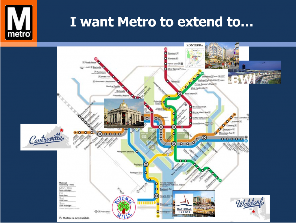
As the region grows, so does the pressure for extensions of Metrorail.  The requests are frequent and common: “Extend Metro to BWI! to Centreville! to Waldorf! to Fort Belvoir!” We’ve heard and even modeled most of these requests. For a system that’s shaped and contributed tremendous economic value to the region, it only makes sense that communities outside of its immediate reach want improved access to it. WMATA Director of Planning Shyam Kannan recently took the opportunity to discuss the potential for the extension of Metrorail into Prince William County. With 80% of today’s Metrorail trips going to or through the system’s core (PDF), he noted that major core capacity improvements must be made prior to considering any additional rail extensions. While addressing core capacity has been a major part of Momentum, including initiatives like the 8-car train program, core stations, and New Blue Line Connections, the plan remains largely unfunded. With safety and state of good repair needs as Metro’s top priorities and core capacity relief put off indefinitely, any potential extensions (if they happen) are likely decades away from being built.

Read more…

ConnectGreaterWashington – a Vision for a Responsible and Prosperous Future (Part 2)

December 1st, 2015 Comments off

Investing in the region’s activity centers that have high-capacity, high-frequency transit and enhancing them as proposed in the Place+Opportunity report is part and parcel to preserving the economic competitiveness of the region AND creating a financially-sustainable Metrorail system.

(This post is part of a multi-part series about Logo_WMATA_CWG_001 black-01ConnectGreaterWashington and the study’s application of land use as a transportation strategy. Part one of the series discussed why Metro cares about land use and the potential benefits of assessing growth from a regional perspective. Part two below outlines the study’s goals, assumptions, and approach.)
WMATA planners posited that changes to local jurisdictions’ and/or the region’s approach to land use and other policies would enable better use of the transportation system this region already built rather than require it to spend billions on new projects. Money is not falling from trees to expand transit — the region hasn’t even agreed to fund enough rail cars to run all eight car trains! So, if the region can’t (or won’t) invest in transit to keep up with growth, then we need to carefully evaluate how the growth we are forecasting can use the infrastructure we already have. Can the region’s growth, rather than necessitate billions of dollars in new infrastructure, be thoughtfully planned to better utilize the roadway and transit systems we already have? What would that mean to the region, its finances, and to Metro’s operating subsidies that its funding partners pay annually?

We developed an Executive Summary (pdf) that summarizes our approach and findings. These posts are infinitely more detailed, but you can certainly glean the key points from the Executive Summary.

The Basics

First and foremost, this study did not seek to develop an optimal land use or in any way socially engineer where future population and jobs should go. These are “what if” scenarios to provide context, data, and information to citizens, decision makers, and elected officials as the region grapples with future job and population growth, demand for transit, and development of walkable communities. This study sought to consider where future growth could go, and worked only with the regional growth anticipated to exist in this region in forecasts from 2020 through 2040. The modeling left existing jobs and population exactly where they exist today and was mindful that anything already in the development pipeline was far enough along to be assumed as “in place”.

Second, we followed the place types defined in Place+Opportunity as they were identified, developed, and defined by local jurisdictional planning staff and the Metropolitan Washington Council of Governments (MWCOG). Why? Because we wanted this study to be as realistic as possible and remain true to the nature of the activity centers and the jurisdictions that informed their types and densities. Additionally, Place+Opportunity was completed recently (2014) and had significant support and direct input from the jurisdictions and the region.
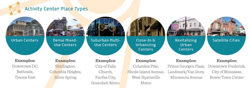
 

Place+Opportunity Place Types

Place+Opportunity Place Types

Read more…

Transit Today, Tomorrow, and Beyond: There’s More to It Than Metrorail

July 6th, 2015 1 comment

In part one of this series, Metro Planners led a session at StreetsCamp  Saturday June 20, 2015 to talk with transit advocates about other possibilities beyond Metrorail to increase transit use, reach, and access.

I want Metro to...

Politicians and citizens always ask for more Metrorail, but why should transit continue to chase land use decisions? Metro Planners Allison Davis and Kristin Haldeman talked to transit advocates and urbanists at StreetsCamp last Saturday to provide approaches that can help the transit we have today reach more people and be more cost-effective without requiring more Metrorail (pdf). The major take-aways for advocates and urbanists were to advocate for:

(1)    Local decision makers to monetize full life‐cycle cost of land use options;

(2)    Access projects that create comfortable (i.e. desirable) paths for pedestrians and bicyclists; and

(3)    Local jurisdictions to add transit signal priority, queue jumps, and bus lanes

Why these three specifically? Read more…

Solving the Region’s Congestion Woes – One Step at a Time (Part 2 of 3)

March 24th, 2014 4 comments

Improving pedestrian connectivity takes cars off the road at a formidable clip – rivaling the power of all of the region’s planned roadway additions and “last mile” transit connections.  Cheaply and quickly. 

This post is part two of a three-part series.

The data is finally in, and we now know that walkable station areas result in fewer motorized trips, fewer miles driven, fewer cars owned, and fewer hours spent traveling. And when we improve the pedestrian and bicycle access and connectivity to Metrorail station areas, ridership goes up, putting a major dent in congestion by taking trips off the roadways. Earlier, we discussed what it means to build walkable station areas and research shows the tremendous benefits to the region of making this a priority.

First, our data confirms that when walking access to transit is improved, transit ridership goes up – way up. In the 2040 Regional Transit System Plan (RTSP), we stress tested TPB’s transportation model to improve walkability to the transit network and saw huge increases in transit linked trips.  These trips go up by about 10% region-wide and we get an increase in transit mode share for all regional trips by 0.5%.  That’s over and above the roughly one percent increase in mode share we anticipate occurring as a result of building the entirety of the CLRP, an impact about half that of constructing all of that transit.

Source: Regional Transit System Plan

Source: Regional Transit System Plan

Read more…

Changing Metro’s Funding Trajectory

February 10th, 2014 2 comments

The Transportation Planning Board (TPB) estimates that without funding commitments from Congress, the District of Columbia, Maryland, and Virginia for Metro’s ongoing maintenance and core capacity improvements, as many as 32,000 future daily transit riders would be pushed onto the roadways instead. 

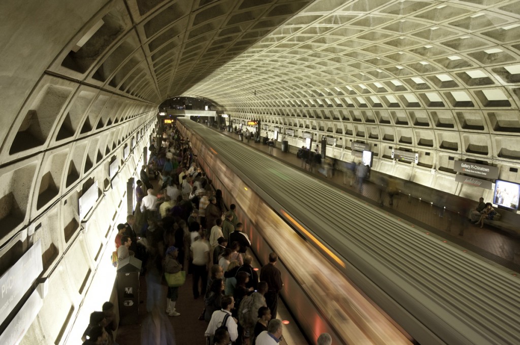
In a recent report, the TPB cites that under the current funding trajectory, Metrorail riders will face significant crowding and experience less service reliability in the future.  Critics often cite low forecasts of future Metrorail ridership from the TPB as a reason to avoid committing robust levels of funding for transit.  What they don’t tell you is that the ridership numbers emerging from the travel demand model are manually “capped” so that there is no ridership growth beyond 2020 – the year beyond which current levels of maintenance funding levels expires.  In other words, because regional leaders have not committed to funding transit, those that forecast travel demand have decided to stop forecasting increases in transit usage.  Were it not for this artificial “cap”, travel demand forecasts would show much higher numbers of future transit use.  We all know that such a “cap” ignores the last 10-15 years of increasing transit usage region-wide (performance analysis of the CLRP Gallery Place pm Rush 042310-2362)

Metro’s strategic plan, known as Momentum, proposes a number of core capacity improvements to handle more riders, and offers a plan of initiatives necessary to remove the so-called “transit constraint” placed on the system in 2000Metro 2025, one of the main components of Momentum, includes:

Read more…

Categories: In The News Tags: , , ,

RTSP Evaluating and Prioritizing Corridors for High Capacity Transit: Dispatch from TAG Meeting #10

October 4th, 2013 1 comment

This is the second post in a two-part series based Logo_WMATA_RTSP_001 blackon content from the tenth meeting with the Regional Transit System Plan (RTSP) Technical Advisory Group (TAG) that was held in July. The first post focused on our analysis of new Metrorail lines in the core and Virginia. This post is about our approach to identify regionally significant corridors for high capacity transit. 

By 2040, multiple regionally significant travel corridors will need high capacity, high frequency transit to connect people and jobs outside of the core.

As part of the RTSP, we will identify regionally significant corridors where transit priority infrastructure is needed to provide high capacity transit. At the TAG meeting, Metro Planning staff presented a methodology to identify, evaluate, and prioritize these regionally significant corridors. The methodology has evolved since the July meeting and is described below. The actual evaluation and prioritization is still in process.

WMATA RTSP II Corridors Segments 082813

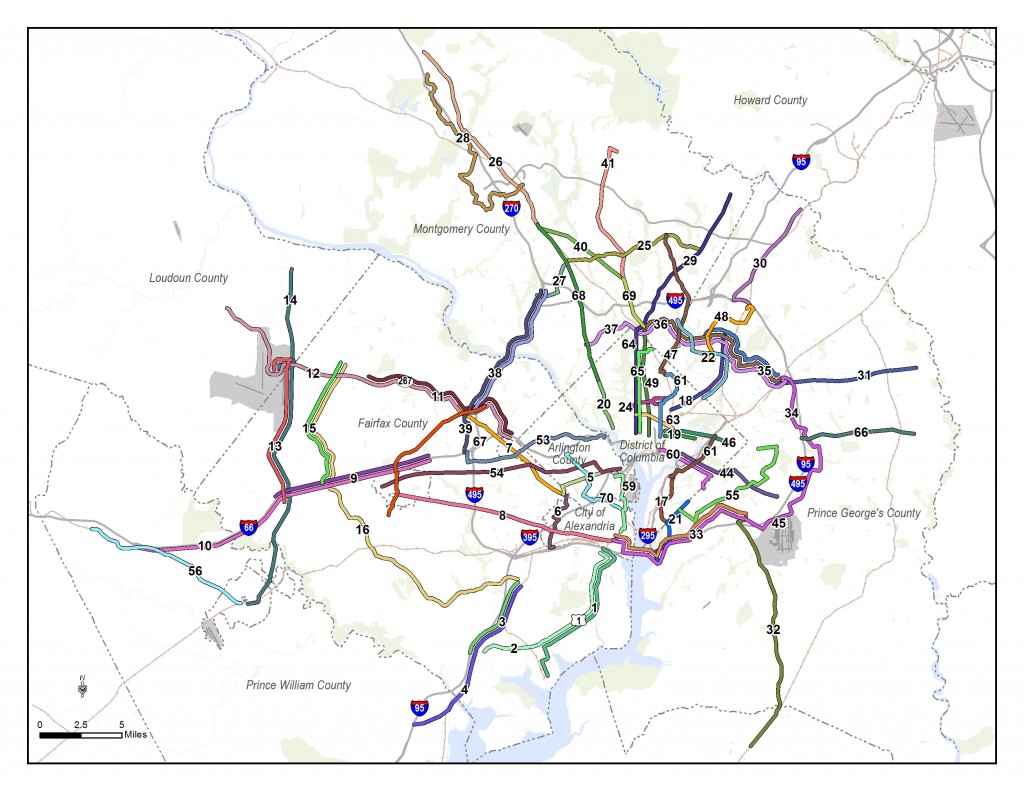
Corridors identified for evaluation for high capacity transit.


Since the TAG meeting, we have also conducted one-on-one meetings with each jurisdiction and agency in the RTSP study area to review and gather feedback on the full set of corridors that will be evaluated. Approximately 70 corridors have been identified from:

Read more…

RTSP Analyzing New Metrorail Lines in the Core and Virginia: Dispatch from TAG Meeting #10

October 3rd, 2013 39 comments

This is the first post in a two-part series based Logo_WMATA_RTSP_001 blackon content from the tenth meeting with the Regional Transit System Plan (RTSP) Technical Advisory Group (TAG) that was held in July. This post will focus on our analysis of Metrorail capacity and crowding, while the second post will focus on identifying and prioritizing regionally significant surface transit corridors.

By 2040, ridership and crowding levels on Metrorail indicate the need for a new Blue Line and new Yellow line in the system’s core and a third line in Virginia.

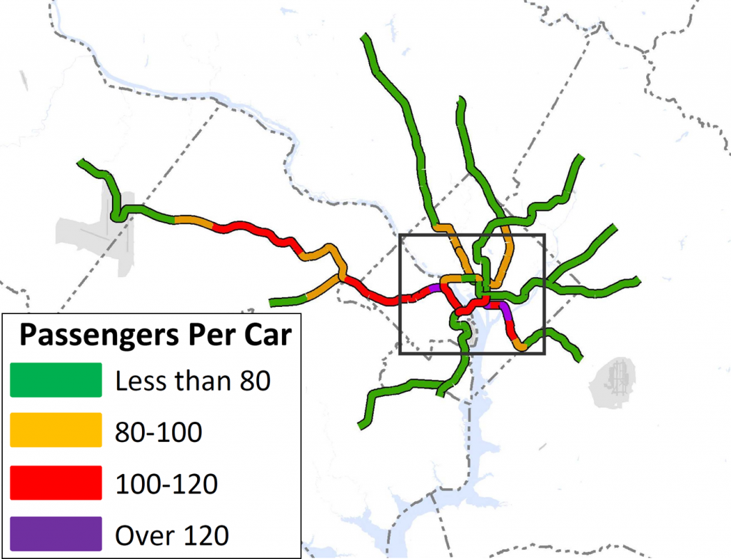
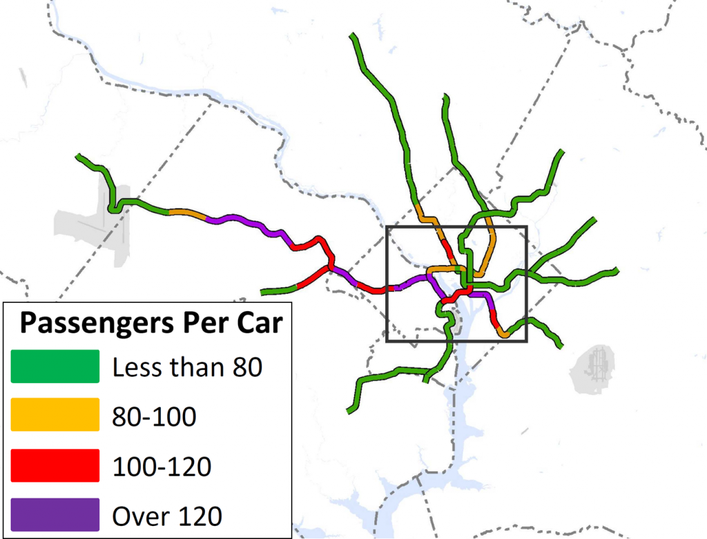
At the time of our last post, we had run an initial round of four scenarios that sought to resolve regional mobility issues. We gathered a lot of information from the results, but realized that we needed to run a second round of scenarios focused almost entirely on Metrorail. Using MWCOG’s Cooperative Forecast Round 8.1 land use, which has been adopted by the region, and MWCOG’s Aspirations land use, which shifts more jobs and households into the regional activity centers, the maps below clearly demonstrate crowded conditions in 2040. The Base Network shown in these maps includes 100 percent eight-car trains and all the CLRP projects. Crowded conditions exist on the Orange Line west of Rosslyn, on the Yellow and Green Lines south of L’Enfant Plaza, and on the Silver Line west of Tysons. Because the results indicated that Metro would be severely crowded EVEN if we run the longest possible trains (eight-car trains), we wanted to explore other long-term solutions.

WMATA-RTSP-II-Baseline-No-Aspirations-Land-Use-Loads-071513-wLEGEND

Crowding on Metrorail by 2040, even with the longest possible (eight-car) trains. Base Network AM Peak, Round 8.1 Cooperative Forecast

WMATA-RTSP-II-Baseline-Aspirations-Land-Use-Loads-071513-wLEGEND

Crowding on Metrorail in 2040 even with the longest possible (eight-car) trains, Base Network AM Peak, Aspirations Land Use

Read more…

Metrobus Priority Corridor Network Evaluation

November 17th, 2010 Comments off

Potential of Improved Running Ways to Increase Bus Ridership, Reduce Bus Operating Costs, and Increase Effective Road Capacity

Buses operating on surface streets in mixed traffic experience delay from a variety of sources, including traffic congestion, bus stops, traffic signals and passenger movements.  As our region continues to grow and economic conditions make bus an ever-more appealing option for travelers of all kinds, Metrobus corridors experience more and more delay.   This delay results in increased costs for bus passengers in terms of travel time,  and increases the cost of providing bus service:  additional buses and operators must be added to maintain desired service frequencies.

One of Metro’s proposed solutions to the increasing costs and continued degradation of bus service is the Priority Corridor Network (PCN).    Metro has identified 23 high ridership corridors to receive priority treatments, which consist of both service adjustments as well as improvements to the bus (street) runningway.  Service adjustments proposed include restructured routes and schedules, skip-stop operations and additional service overlays.  Runningway improvements could include bus lanes, transit signal priority, queue jumpers, bus stop location, and off-board fare payment systems.

Read more…

Categories: Planning Studies Tags: , , ,