Posts Tagged ‘land use’

Marriott’s Headquarters in Bethesda Helps Metro

November 29th, 2016 1 comment

The relocation of Marriott’s headquarters to downtown Bethesda would bring new riders and revenue to Metro, without straining Metro’s capacity. A win-win!

bethesda_aerial

Downtown Bethesda

Marriott last month announced it will move its headquarters to downtown Bethesda, bringing over 3,500 employees to a location that’s now accessible to the Red Line. The move will help Metro by attracting more riders and fare revenue to the Red Line.  Using our S.W.A.R.M. model, we estimate that the new headquarters will bring about 1,200 new boardings/day on Metrorail, and over $1 million per year in new fare revenue.

What’s more, we’ve already got space for these new riders.  Since most of the new riders would be reverse-commuters (towards Bethesda in the morning) or would originate in Montgomery County, they would not strain existing crowding on-board trains at our pinch points, a.k.a. our maximum load points. Bethesda station has sufficient vertical circulation capacity for them as well.  In short, this move is a win-win for Metro, the riders, and our funding partners, and we applaud the decision.

Introducing S.W.A.R.M. – Another Tool For Your TOD Toolkit

August 11th, 2016 1 comment

A new tool helps estimate ridership and revenue from transit-oriented development projects near Metrorail stations.  Download it for yourself!

Waterfront Sta aerial

For months we have been detailing our work that quantifies the relationship between land use and rail ridership. This is important because Metrorail has been experiencing large changes in ridership, and we were interesting interested in understanding why certain station areas – like Navy Yard and NoMa – were showing ridership gains while the system as a whole is experiencing losses in the long arc of ridership growth.

To get to the bottom of this, we worked with researchers from the University of Maryland’s National Center for Smart Growth to analyze how walk ridership at a Metrorail station relates to its surrounding land uses, and create a tool that accurately estimates the likely change in ridership from changes in land uses. This tool, the Station Walk Area Ridership Model (or S.W.A.R.M., for short), helps us estimate the potential impacts of land use changes – new households, new jobs (by type of employment!), and even changes in the station’s walkshed – on ridership and revenue to Metrorail. Read more…

Help Metro Get Smarter: Now Hiring Business Intelligence Analyst

August 4th, 2016 1 comment

If you are great with data and love cities and transit, we have a job for you.

now_hiring-01

We were excited to announce that a job listing for a Business Intelligence Analyst position within Planning’s Applied Planning Intelligence unit has just been posted.  We are looking for a healthy overlap between a data scientist and a transit nerd.  For the full job description, head over to the wmata.com/careers site, scroll down and click on View all jobs.  A short description is posted below.

Currently a team of two, we work to convert Metro’s many data sources into information that can be used to inform plans, policies and procedures.  Many of our projects have been featured here on PlanItMetro, including:

Read more…

Would a Cordon Charge Help Stabilize Metro’s Finances? (Part 4)

July 5th, 2016 2 comments

Adding a London-style cordon charge (or fee) to enter much of the region’s central employment area would increase transit ridership across all modes and also reduce (or eliminate) the subsidy that local governments pay every year to support Metro, meaning lower tax bills for regional residents.*

(This post is part of a multi-part series about ConnectGreaterWashington (CGW) a study that WMATA completed in 2015 and its application of land use and pricing as a transportation strategy.)

Approach for Building Scenario B to make Transit More Cost-Effective

Scenario “B” looked at land use shifts and increasing the price of driving, and how those changes would impact Metro.

Metro asked, “What if the region’s future growth was used to fulfill the expectations of regional plans such as Region Forward and Place + Opportunity? What if transit-supportive policies were implemented across the region? Would WMATA benefit? Would the region?”

Answer: YES!!

*Note that Metro is not proposing that the region adopt a cordon charge, but it was tested as part of an analysis of how smarter land use and more transit-supportive policies could impact transit ridership, our operating subsidy, and other measures that support the region’s growth.

Read more…

Acting Regionally Pays Big Dividends (Part 3)

March 10th, 2016 Comments off

Adding jobs and households in transit-served areas not only increases Metro ridership, but also reduces and may even eliminate the subsidy that local governments pay to support Metro, meaning lower tax bills for regional residents.

(This post is part of a multi-part series* about ConnectGreaterWashington a study that WMATA completed in 2015 and its application of land use as a transportation strategy. The below post and links provide additional detail.)

In December of 2015, public and private leaders issued a call to action for the many jurisdictions in this region to start acting as one.  We’ve actually been thinking about this for some time, and their announcement timed well with our desire to share perspectives on the following questions.

Questions:

  • What if the region’s future actually approached the goals of collaborative regional plans such as Region Forward and Place + Opportunity?
  • Would WMATA and the region benefit?
  • Are there financial, social, quality of life and environmental benefits?

Answers: YES, YES, and YES!

Approach: Metro planners hypothesized that changing local jurisdictions’ and/or the region’s approach to future land use decisions, such as where to guide future jobs and population and expanding transit-supportive policies, could enable the region to better use the transportation system we already have rather than require us to spend tens of billions on new transportation projects.

Planners developed three different scenarios (A, B, and C) that used the transportation system we already have, but modified future growth policies that determine travel patterns. The below post talks only about Scenario A, which had a specific goal to increase ridership on all segments of the Metrorail system, while minimizing the potential for overcrowding on any segment in the system. The image below shows how we built Scenario A and its three iterations (A Prime, A1, A2).


Approach for Building Scenario A to make transit more efficient

Read more…

Right Underneath our Feet – How Planning, Zoning, and Development Influence Metrorail Ridership

January 12th, 2016 4 comments

Metrorail ridership is heavily-determined by station-area land use patterns, so attention to land use as a transportation strategy will be important to sustaining Metrorail’s long-term ridership growth.

There has been a tremendous amount of attention recently paid to Metrorail’s ridership trends.  While history tells us that the current ridership snapshot – which shows that ridership has essentially flatlined – is quite normal given the cyclic nature of ridership growth, Metro’s Office of Planning has been exploring why certain station areas and rail segments have seen ridership gains during the downturn, while other station areas and segments have seen losses.

Passenger Miles Traveled by Trip Origin at Each Metrorail Station, AM Pea, Full-Fare Riders with no Transit Benefits. One of the inputs from this study.

Passenger Miles Traveled by Trip Origin at Each Metrorail Station, AM Pea, Full-Fare Riders with no Transit Benefits. One of the inputs from this study.

The questions we sought answers to included, for instance:

  • Why is it that while system-wide ridership declined last year, we saw ridership gains at stations with lots of transit-oriented development, such as NoMA, Columbia Heights, and Navy Yard-Ballpark?
  • How much of an impact does transit-oriented development have on overall ridership, and can that impact be measured, both in terms of new ridership as well as in terms of net new farebox revenue?
  • With so many ways to get around – including walking and biking and Uber and Lyft – and gas prices at near historic lows, how does a Metorail trip compare to other ways of getting around in terms of overall competitiveness?
  • Does the location of a transit oriented development project matter in terms of how much ridership it generates?  Does that vary by the type of project (i.e. office, retail, residential, etc)

Read more…

First Things First

December 14th, 2015 2 comments

Secretary Foxx has issued his direction that Metro cannot consider any new rail expansion right now, and WMATA agrees!  So much so that we wrote it into our strategic plan back in 2013.  Earlier this fall, the Prince William County’s Board of Supervisors heard from WMATA about the importance of fixing Metro’s core before considering any expansion.

The Silver Line’s Phase 2 extension from Wiehle-Reston East to Dulles Airport and Loudoun County could be the last for decades to come. (photo credit: Ryan Stavely, Flickr)

As the region grows, so does the pressure for extensions of Metrorail.  The requests are frequent and common: “Extend Metro to BWI! to Centreville! to Waldorf! to Fort Belvoir!” We’ve heard and even modeled most of these requests. For a system that’s shaped and contributed tremendous economic value to the region, it only makes sense that communities outside of its immediate reach want improved access to it. WMATA Director of Planning Shyam Kannan recently took the opportunity to discuss the potential for the extension of Metrorail into Prince William County. With 80% of today’s Metrorail trips going to or through the system’s core (PDF), he noted that major core capacity improvements must be made prior to considering any additional rail extensions. While addressing core capacity has been a major part of Momentum, including initiatives like the 8-car train program, core stations, and New Blue Line Connections, the plan remains largely unfunded. With safety and state of good repair needs as Metro’s top priorities and core capacity relief put off indefinitely, any potential extensions (if they happen) are likely decades away from being built.

Read more…

Four Key Questions about Metro’s Future with the Federal Worker (5 of 5)

December 9th, 2015 Comments off

The answers to these four questions will shape the future of Metro’s federal customers, and the region’s transportation future. (Fifth and last in a series of posts on Metro’s Federal customers – see posts 1, 2, 3, and 4)

The ATF headquarters adjacent to NoMa Metrorail station has helped grow ridership there significantly.

1. Will the transit benefit be restored to parity with parking? When Congress cut the transit benefit in half, it hurt Metro riders hard. 42% of Metro’s ridership – around 500,000 rail and bus trips per day – comes from riders who use the Federal Transit Benefit, including private-sector workers. At Metro, 22% of all ridership comes from commuters who spend over $130 per month on transit. Following the changes to the SmartBenefits program, Metro saw ridership losses concentrated on these riders hit the hardest, and federal employees overwhelmingly pay with SmartBenefits.

If Congress restores the maximum transit benefit to parity with parking, it would be a huge boon to Metro’s federal customers and Metro’s bottom line. Read more…

ConnectGreaterWashington – a Vision for a Responsible and Prosperous Future (Part 2)

December 1st, 2015 Comments off

Investing in the region’s activity centers that have high-capacity, high-frequency transit and enhancing them as proposed in the Place+Opportunity report is part and parcel to preserving the economic competitiveness of the region AND creating a financially-sustainable Metrorail system.

(This post is part of a multi-part series about Logo_WMATA_CWG_001 black-01ConnectGreaterWashington and the study’s application of land use as a transportation strategy. Part one of the series discussed why Metro cares about land use and the potential benefits of assessing growth from a regional perspective. Part two below outlines the study’s goals, assumptions, and approach.)

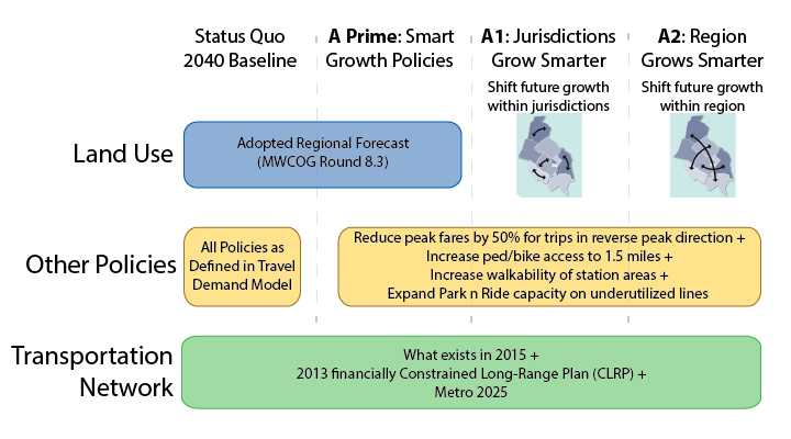
WMATA planners posited that changes to local jurisdictions’ and/or the region’s approach to land use and other policies would enable better use of the transportation system this region already built rather than require it to spend billions on new projects. Money is not falling from trees to expand transit — the region hasn’t even agreed to fund enough rail cars to run all eight car trains! So, if the region can’t (or won’t) invest in transit to keep up with growth, then we need to carefully evaluate how the growth we are forecasting can use the infrastructure we already have. Can the region’s growth, rather than necessitate billions of dollars in new infrastructure, be thoughtfully planned to better utilize the roadway and transit systems we already have? What would that mean to the region, its finances, and to Metro’s operating subsidies that its funding partners pay annually?

We developed an Executive Summary (pdf) that summarizes our approach and findings. These posts are infinitely more detailed, but you can certainly glean the key points from the Executive Summary.

The Basics

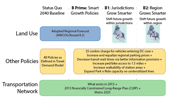
First and foremost, this study did not seek to develop an optimal land use or in any way socially engineer where future population and jobs should go. These are “what if” scenarios to provide context, data, and information to citizens, decision makers, and elected officials as the region grapples with future job and population growth, demand for transit, and development of walkable communities. This study sought to consider where future growth could go, and worked only with the regional growth anticipated to exist in this region in forecasts from 2020 through 2040. The modeling left existing jobs and population exactly where they exist today and was mindful that anything already in the development pipeline was far enough along to be assumed as “in place”.

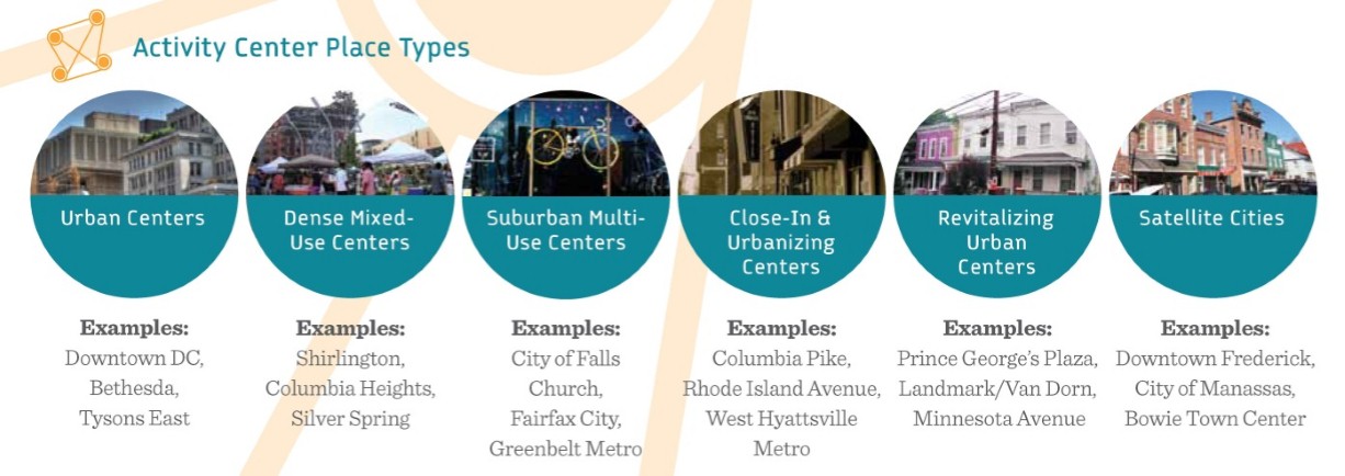
Second, we followed the place types defined in Place+Opportunity as they were identified, developed, and defined by local jurisdictional planning staff and the Metropolitan Washington Council of Governments (MWCOG). Why? Because we wanted this study to be as realistic as possible and remain true to the nature of the activity centers and the jurisdictions that informed their types and densities. Additionally, Place+Opportunity was completed recently (2014) and had significant support and direct input from the jurisdictions and the region.


Place+Opportunity Place Types

Place+Opportunity Place Types

Read more…

Prioritizing Bike and Pedestrian Station Access Projects Near Metrorail, Part 2

November 24th, 2015 Comments off

Other than ridership potential, what are some of the other ways we can rank access projects relative to each other?

In our last post, we discussed how bike and pedestrian access projects relate back to ridership and how that relationship could be used to prioritize projects. In this post, we talk about some of the other criteria we are using to prioritize projects.

Bike and Ped. Fatalities, Sample Data Set

Bike and Pedestrian Fatalities, Sample Data Set

The first is safety. We are pulling together data about bike and pedestrian crashes near our stations that result in injuries or fatalities. We will then link these data in GIS back to the location the project, with the idea being that a new crosswalk or dedicated bike path in an area with a lot of recent crashes should score higher and deserves more attention. A safer path of travel helps not only our customers but all walkers and cyclists in these areas.

We also want to explore some other prioritization criteria. Here is what we have come up with: Read more…