
Proposed 2040 Metrorail Network
Step right up and check out the proposed 2040 core Metrorail configuration with new Blue and Yellow Lines and a third line in Virginia!

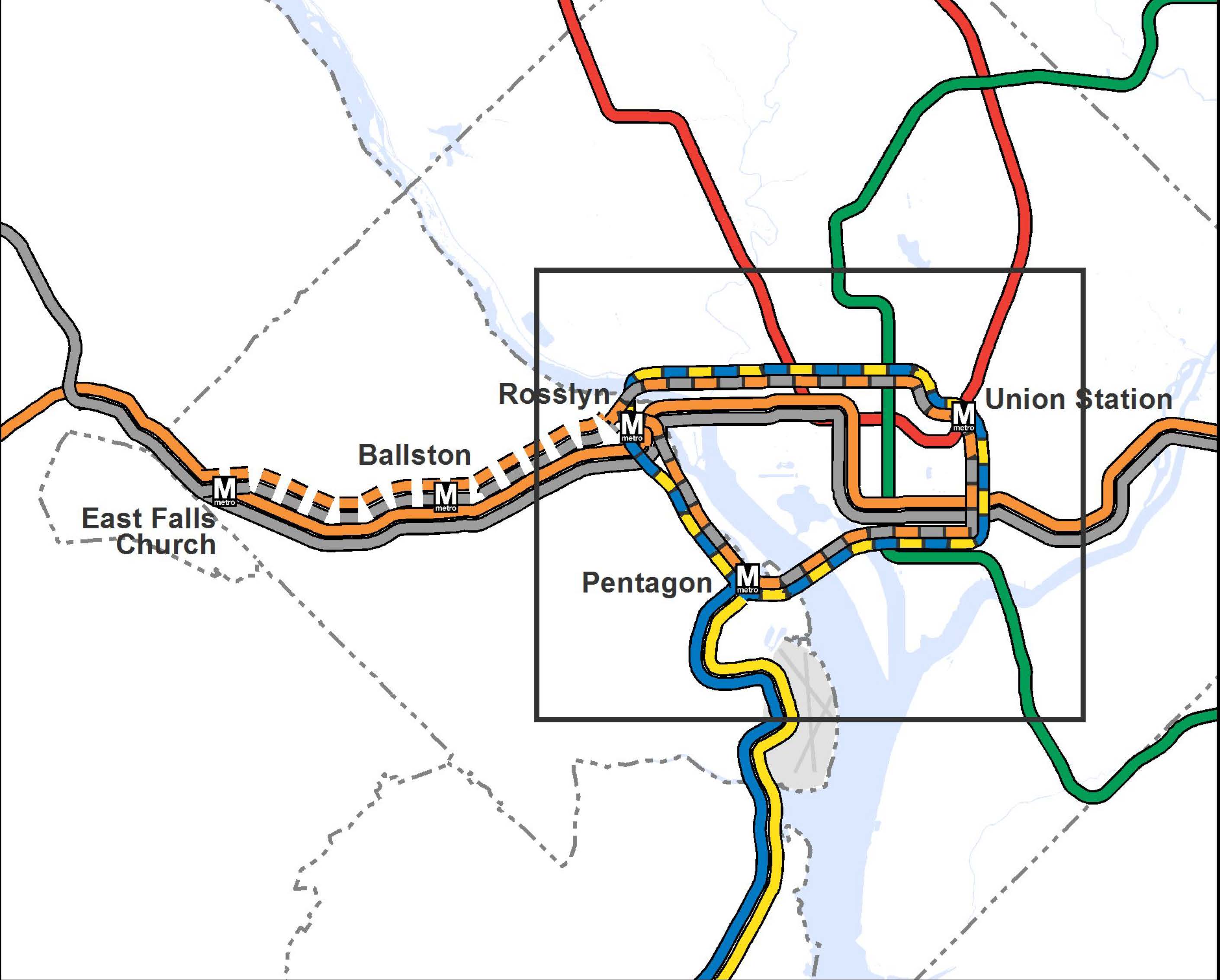
Proposed 2040 Metrorail Core Configuration
Proposed 2040 Metrorail Network
What does this network do? The proposed rail network shown above is expected to reduce future crowding on Metrorail, provide enough capacity for future development, and expand the reach of transit in the region, especially to regional activity centers.
Why are we proposing it? This rail network is part of the 2040 Regional Transit System Plan (RTSP). Its purpose is to develop the rail and surface transit network for 2040 that meets the needs of the growing Washington DC region.
What else have we considered? About a month ago, we posted about some of the possible long-range changes to the Metrorail core that we are considering as part of the RTSP. We analyzed four different core configurations, gathered your comments, and the final configuration for the core is shown above. As many of you commented, it is a combination of two of the scenarios (Scenarios B and C).
Next Steps: The next and final step for the RTSP is to use this configuration, along with the high capacity surface corridors, to conduct a final round of analysis. The output will provide us with information on ridership, mode share, levels of crowding, transfers, etc. and ultimately a final network for 2040.
Let us know what you think!
A few extra notes:
(1) The Metrorail network shown in this post will be layered with an extensive high capacity surface transit network to expand transit and meet the needs of employment and population growth in the region.
(2) For the plan to have validity and acceptability across the region and within the federal planning process, it is based on the region’s adopted cooperative land use forecast for 2040. We used the Aspirations Land Use scenario to stress test the core of the system, but ultimately the plan needs to start with the region’s adopted land use. As follow on work to this plan, we will be testing different land uses to see what else we can learn to improve long-range plans.
(3) All of the lines shown, as well as all of the high capacity surface transit corridors, will need corridor studies, alternatives analyses, and full engineering studies. This cannot be done at a regional level, but would need to happen on a project by project, line by line level. So, while we are showing a new Blue Line on M Street, it very well could be on N or P Streets.

Is there anything in the plan about how this downtown circle line would allow for further extensions in DC east to Capitol Hill and north through underserved areas along Georgia Avenue? The surface transit plan will help some, but areas along Georgia Ave north of the Petworth station could be developed much more densely if they had Metro service in the future.
Also, I can’t say I understand the desire for an “express” line along 66 to East Falls Church. If you connect that express track back up to the existing track in the 66 median between Ballston and East Falls Church, you haven’t added any capacity. If you connect that to the circle line, you will run into the same issue you have now with the Rosslyn tunnel, only the tradeoff will be taking capacity away from the Rosslyn-Ballston corridor to run express trains around to the new Rosslyn station and into DC.
@Matt Dickens
Great points/questions. We tested both the extension of the Blue Line further west along H Street and the Yellow further north along North Capitol. With the proposed land uses, neither showed great ridership potential that merited Metrorail. However, that is not to say that the future wouldn’t be different if the land use changes dramatically from what is proposed. So, in terms of construction, we would not want to preclude the possibility of post-2040 expansion/extension of those lines. But with the 2040 land use, the need for Metrorail just isn’t there.
As for the express line - you are absolutely correct that bringing them together anywhere is limiting. Though it isn’t obvious from the map, we don’t plan on doing that. Therefore, there would need to be more than two tracks for a portion between Ballston and East Falls Church. Again, full corridor analysis would need to happen to determine the feasibility of this and where, exactly a third line in Virginia should be located, but our modeling results show demand on that corridor for a number of reasons. First, the Orange Crush will be somewhat abated by fully running 100% eight-car trains, but by 2040, if not before, our results show it returning. Also, the loop as shown needs to have bi-directional service (e.g. clockwise and counterclockwise). If it were only fed by the Blue and Yellow line from South Arlington and Alexandria, at most, we would only have thirteen trains an hour in either direction. The third line in Virginia would feed the circle line, maximizing the infrastructure investment, as well as providing good frequency of service on that line.
I like the loop for an interim step, but I would like the plan to specifically call out future extension opportunities (as many of the other alternatives discussed).
For examle, while your analysis may not show supportive land uses for extending the Blue line under H St NE between Union Station and River Terrace, this is nevertheless a key link in the network that would be missing under this plan; further studies should not foreclose on adding this link to the network.
The same applies to any northern extensions of the ‘yellow’ part of the loop.
I very much like that this proposal better, which I’m going to call the circle line; It’s a good combination of two of the previous scenarios (Scenarios B and C), taking the best parts of both and creating a new one that not only adds commuter capacity but also opens up some new stations in the core (ex. Georgetown and Capitol stations). It also appears that the new circle line station that connects to Union Station is right under the streetcar platform for Union Station. Kudos for intermodal connections!
That said, there’s more to these things than building more lines and track. Because the map indicates more shared trackage, it’s two steps forward, one step back. The big limitation remains that since lines are sharing trackage, one can’t merely max train capacity by purchasing rolling stock and hiring staff since the the finite number slots for trains are already used up by other lines on the communal track. This sharing of track causes cascading complications when the circle line gets trains from four lines, all that share track with the “regular” versions of the lines.
On each section of track, there is a maximum number of trains that can run per hour, which I believe is about 26 slots. Let’s say you wanted to split the circle line evenly between the Orange/Silver and Blue/Yellow. Thus, you’d have 13 Orange/Silver and 13 Blue/Yellow.
For the Blue/Yellow that means you send 13 trains per hour onto the circle line past pentagon. What about the other 13 train slots on the Arlington Blue/Yellow? Is metro planning to put a pocket track beyond the platform at Pentagon to send the other 13 train slots back to Huntington/Springfield? If not, you can *only* have (26 minus 13 Orange/Silver circle trains) of Blue/Yellow trains at Pentagon. This is because during rush, without a pocket track, there’s no place for trains to turn around quickly, safely enough, which is why Rush Yellow doesn’t go to Fort Totten now. Mt. Vernon has one. (There is a pocket track at National that the other 13 trains could turn around at, but why only go that far?).
Also in this new scenario, regular Orange/Silver share track between just east of West Falls Church to Stadium Armory (For those wondering what happens to Largo, most likely the Blue Line trains here would just become Silver ones, increasing capacity to Tysons). The Orange/Silver and Circle line appear to split at East Falls Church. Want to send those 13 trains east onto the circle line at East Falls? Well that means you’re not sending 13 trains to the current Orange/Silver to Largo/New Carrollton. That would leave 13 trains in the Ballston-New Carrollton/Ballston-Largo Corridor. (There are currently 19 trains per hour in Rush+ Orange) Is metro planning to build a pocket track west of Ballston so they can send more trains out of Largo and New Carrollton? Unlike Blue/Yellow, there’s no pocket track west of Stadium Armory and East of West Falls. Otherwise, this will be a service reduction.
You can fiddle with the numbers of course and perhaps metro wouldn’t max out the circle at first, but it comes down to the fact that with shared trackage, for every train you send down the circle line side of a track split is one train you are not sending down the regular line. That leaves you, just like today with the Yellow Line bridge and the Green/Yellow north of Mt. Vernon, the Arlington Cemetery section, etc with unusable wasted capacity.
@Jared Christian
Thanks Jared - please note my comments above. The circle line would have trains in both directions, being fed by the third line in Virginia and the Yellow/Blue (which in theory could just become one color). Each of those could max out at 26 trains per hour or 52 trains total, 26 clockwise in the loop, 26 counterclockwise in the loop. Therefore you don’t need the turnbacks you mentioned. Additionally, the third line would not lessen what is currently operating on the existing Silver/Orange because there would be more than two tracks west of Ballston. Additionally, building the second Rosslyn station and completely separating the Blue Line from the Orange/Silver Lines would increase the number of trains through the existing Rosslyn/Ballston corridor to max out at the 26 trains/hour.
@Alex B.
I like your “interim step”, Alex. While I definitely get your point and we plan to make note of that, this is a pretty ambitious plan. Three new rail lines plus a significant increase in high capacity surface transit is not nothing and will be a hard sell in the region to begin with. Opportunities for expansion abound, both in the District and from end of line stations, but the land use just isn’t there for this planning horizon.
Also, how would these trains be signed? This will be a conceptual problem for WMATA. WMATA trains are signed by destination. Period. Blue Line goes to Largo/Franconia, Orange to Vienna/New Carrollton, etc. Trains don’t cross. (This is why Rush+ Franconia Trains are Yellow. It would be weird to have two Franconia trains on two platforms and levels at L’enfant)
For example, A blue line circle line train appears to be starting at Franconia going to Pentagon, taking the circle line around to pentagon again, then back to Franconia. Can you get on a Franconia train on both sides of the platform? How will a tourist know which one is quicker? What will the station signage say? Will there have to be differentiation between inbound and outbound trains? If so, will the train sign have to change some time during the journey? (Start as Pentagon/Downtown, then sometime later change to Franconia? Where would it change? (I.e. where does it stop being inbound and start being outbound?) As soon as it enters the circle line? When it leaves? In the middle? Would that be confusing? Would that be jarring to see your 7000-series car change the destination sign on you? Another comment mentioned bi-directional service. How would I know that an inbound train is going clockwise to Rosslyn or counter-clockwise to National Park?
Take this example PIDS using the current signage system with the Arlington Cem station on the circle line.
Track 1 (Clockwise)
LN CAR DEST MIN
BL 8 Franc-Spg 3
OR 8 Vienna 6
YL 8 Huntington 12
SV 8 Rt 772 15
Track 2 (Counter-clockwise)
LN CAR DEST MIN
SV 8 Rt 772 2
YL 8 Huntington 5
BL 8 Franc-Spg 7
OR 8 Vienna 14
PIDS outside fare gates:
LN CAR DEST MIN
SV 8 Rt 772 2
BL 8 Franc-Spg 3
YL 8 Huntington 5
OR 8 Vienna 6
See how that might be confusing? Tho, if by 2040 there’s all eight car trains, then the Car column could be repurposed to help out.
@Jared Christian
And of course, after I put so much effect into that example I posted, I realized I should have gone with the pentagon example I mentioned instead of the Arlington cem one I used. It actually does make sense some sense on the circle stations themselves. Track 1 goes one way track two goes another. It’s the trains that cross on their way to and from the circle line that are completely confusing without a signage concept change. There possible blue line trains at Pentagon.
PIDS outside fare gates at Pentagon:
LN CAR DEST MIN
BL 8 Franc-Sgn-Circle-Clock 3 (Inbound first to Rosslyn)
BL 8 Franc-Spg 5 (Inbound to Franc-Spg)
BL 8 Franc-Spg-Counter-Clock 7 (Inbound first to Nats Park )
Would all the lines travel in both directions around the loop or would, for example, the yellow and orange+ run counterclockwise and the blue and silver+ run clockwise?
@Jared Christian: FWIW, trains headed to Chicago’s Loop are just signed “Loop.” It’s up to you to figure out which way said train circulates around the Loop — which, granted, has half as many stations as this loop.
Although I’m a huge fan of blue line separation in the District, waiting to 2040 to accomplish this is ridiculous when the system is already maxed out. Also, this plan also continues to favor the original hub and spoke system, without really considering changes in land use in the older suburbs that could dramatically benefit from Metrorail’s transit-oriented development (read: R-B corridor type of revitalization and density-driven development). VA still needs a cross-county connector. I’d favor extending the Silver line down Route 7 and then up Columbia Pike, use the bulb out at the Pentagon station to continue it along the Yellow line or another new line in the District. Albeit a connection will be required for many riders, this will eliminate the expensive need for a parallel line through North Arlington while contributing greatly to development along 7 and the Pike.
As for surface transit improvements, that’s all and good, but if we’re talking light-rail/streetcars, the only way to go is separated ROW. Trust me on this. I live in San Francisco where the surface lines crawl in mixed traffic. Sure, trains have more of a visual appeal than buses, but the latter have faster stop/start times and can maneuver through traffic.
Also, by 2040 traffic will be so horrendous in VA given the pro-sprawl, anti-transit development going on in the exurbs.
Overall, the proposal seems rather strange in suggesting the new lines should follow the existing lines way too closely. While I understand the need for a line between Union station and Georgetown parallel to the existing lines (this is a very dense and busy corridor indeed), I don’t see why a new line in Virginia must follow the existing Orange/Silver lines so closely - within half a mile or so!
Also, the circular configuration seems rather questionnable, because all the branching reduces the potential service frequency. The WMATA should think of through lines with a single route in a single corridor (like the existing Red line) instead of all this merging and splitting with multiple routes following the new “circle”. You should already see by now that the idea of trunk routes and branches is not good for a busy metro system like DC’s. Some transfers are unavoidable, and one cannot get a direct ride from any point A to any other point B, so there is no point in trying to save on the core capacity.
Here is an example: take the third (new) line in Virginia, run it through Georgetown and Union Station precisely along the proposed “circle line” and then continue it via the existing metrorail bridge to Pentagon and the current Blue and Yellow lines. This will make it a single through line with no branches (and hence no detriment to the service frequency), i.e. exactly like the Red line, yet it will serve all the same areas and lines without the complications of your circle plan.
Also, one way circles are a very poor idea from the passenger perspective - just study the known examples in other cities, it does not work anywhere. When you can travel one way from A to B, but not the other - this is very confusing and inconvenient for many passengers. It might work for a small loop, but a loop of the size you proposed is almost guaranteed to fail due to this uni-directionality.
In general, this proposal seems like a patching work to fill the existing potholes, but not a master plan for the next 50 years.
Allison, thank you so much for your quick and clear responses! I didn’t even know anyone was listening and I’ve gone back and re-read some posts :)
I think the Corridor Study analysis process can not be stressed enough. While the map above is descriptive, its hard not to get caught up in minutiae of station intersection locations and which streets the track might follow. Though its nice to look at something more real then the broad strokes of sketches past. Thanks!
A first quick thought: why is Metro not using its http://wmata.mindmixer.com/ website anymore? Is there a difference between this site and that site, other than that one not being used anymore? This seems like something that would be a good ‘mind mixer’ topic.
Whew. Where do I begin? I highly agree with two key issues raised already: 1) express tracks in VA really do no good if they end up merging into a new choke point as well as a traveling on a Yellow/Blue/Orange/Silver circle line, with all of the two track issues we currently have; 2) the complexity of signaling to customers where a train is going in this system (a hybrid loop/circle and hub and spoke).
What I like about this proposal is that it keeps the idea of a new M street (or somewhere nearby) line traveling east/west through VA, Georgetown, and hitting Union Station but it also discards the idea of a separate Yellow line paralleling the Green line nearby AND that it locates a new Yellow Line further east in an under served north/south corridor (rather than a few blocks west of the current Yellow/Green line).
I also really like the added connections to southwest and southeast, areas that have great potential for increasing development and density. I also appreciate the effort to fix the current Rosslyn choke point, but the result is a spaghetti dinner of lines merging and diverging and going in all sorts of directions.
At a fundamental level, I’ve previously supported - and continue to support - the idea of a ‘circle line’ in DC. But, in my mind, such a line is ONLY a circle/loop without branches outside DC. Importantly, this loop is separate from any consideration of express tracks in VA heading into DC or a new blue connection into DC via Rosslyn and Georgetown. In my mind, a circle line in DC should be a true ‘subway’ dedicated to moving people around IN DC (not in and out). It would be a line with different hours, service patterns, fares, etc, as well as different expectations for ridership. But it would be a subway and not subway/commuter rail like Metro is currently designed for. Having a loop/circle line like this avoids many of the issues that are being raised with regards to the complexity of a circle that is also a hub and spoke at two different points (Rosslyn and Pentagon). A circle line, like the proposed streetcar network or even the Purple Line, should connect to under served neighborhoods in DC while also connecting to key transfer stations via underground corridors. But overall it should be a separate, non-interstate line.
A circle line is truly what DC needs, so kudos for that. The routing is just a little too close to existing service, though. I would push it further north in the Rock Creek-to-Union Station corridor, further east in the Capitol Hill area, and west of Arlington Cemetary in Virginia. DC needs more cross-town services which connect neighborhoods - I for one value that more than a service which is fundamentally useful for commuters only.
I disagree with having a silver line express. and having two loops, let alone one, will confuse a lot of riders. silver line express just seems like a waste, and as someone else mentioned it’s going back to the same choke area.
why not extend the blue line east beyond union station and have it link with stadium armory? then it can just goes to largo like it always does. I’m sure the H st area would benefit in the future.
This is really great, Allison! These changes will actually contribute to DC having a functional urban rail system. But, wait a second, 2040?! I thought this was the metro system for the capital of the richest country in the history of universe. Right now, there are high-speed intercity lines in Europe and Asia with greater frequency than the blue line runs at most hours of the day. Surely we can accomplish these improvements sooner than 2040 — remember, make no small (or slow) plans!
@James
I agree on this, 2040 is way too far off. why can’t we be more like european/asian countries…
There’s a reason few cities run a circular service, and even better reasons that cities like London have in fact undone their own circle lines.
Here’s a pretty good overview of worldwide systems, and then a direct London comparison:
http://www.londonreconnections.com/2013/uncircling-circle-part-1/
http://www.londonreconnections.com/2013/uncircling-circle-part-2/
In short: a loop poses severe operational difficulties and complexities. You can’t make up time without a terminus station. You certainly can’t gain time that way. You can’t easily add extra trains. You can’t terminate short of the destination. Wheels wear unevenly (an especially large problem given WMATA’s issues with railcar maintenance). Driver relief and shift changes become hard to schedule in.
A loop goes nowhere. This doesn’t set anything up for even longer-term core expansion. It’s so narrowly inward-looking as to have ignored most of the capacity and coverage problems with the system as it stands.
Other than those on the M Street subway (which, granted, is an absolute necessity) and some in the east that are all close enough to existing stations to be transfer points, there are no new stations. The Yellow Line has been separated and then rejoined and no longer separated. In fact, nothing has - interlining seems to be a hallmark of this plan. Why does the Yellow not separate and run further north? Why can’t the new Blue Line head further east and/or north? Why are we doubling-down on the already failed strategy of putting transit in highway medians? Why are we “separating” the Blue Line only to run it concurrently with no less than three additional lines?
Given potential alternative routings, this seems like a wasted opportunity to really think big.
“Let us know what you think!”
I think the shorter version of this article reads: “WMATA to DC residents: Drop Dead”
Overall I like the circle line plans and the extra Rosslyn station. One area I think can be improved on is the Orange/Silver Line express line. I have always thought that having express tracks running on the Orange Line would be helpful. However based on reading other comments and thinking through the potential confusion and overall value of the money spent, I think there may be a better plan for the excess circle line capacity.
Currently we have rail lines for I-66 (Orange Line), Route 1 (Yellow Line), I-95 (Blue Line) and potentially streetcar additions to Columbia Pike. The major corridors that do not have solid transit are the Rt-50, Rt-7 and I-395 corridors. You can say that in a long-term plan, the blue line could shift to I-395 to pick up the commuters to the new Mark Center, Landmark, Skyline, and continuing down through Van Dorn to connect up as the Springfield and I-95 line.
Therefore, it is the Rt-50 and Rt-7 corridors that could truly benefit from having a new Metro rail line. One option could be to use the circle line capacity from the additional Pentagon station shown above and have the line instead head down I-395 (with stops at the Mark Center and at Shirlington) to Rt-7 (with stops at Skyline, at Bailey’s Crossroads/Columbia Pike Streetcar intermodal connection, at Seven Corners/Rt-50, at Falls Church City/Rt 29, at West Falls Church/connection to Orange Line, International Drive in Tyson’s and finally connecting with the Silver Line at Rt-123. This creates additional capacity from DC to Fairfax County via Arlington Country while adding new ridership in major residential and commercial corridors.
Wait, so no existing blue line to the east and over the river? Or is that just not being shown? Sorry for my confusion. Would the silver then extend to serve those former Blue line stations?
Love the new map! Thanks for all the hard work!
@Matt Dickens
I think that’s the idea.
I think that’s the idea. To ease the “orange crush” in Arlington. This bypass with a new “west” Ballston station has been studied since at least the 90s.
@MetroDerp
What is being proposed is not a circle line - it is a loop with termini at the Virginia ends of the Blue/Yellow/Orange/Silver lines. It could also be designed to allow extensions from a point on the loop to other places or even separation of the lines.
2040?! In 2040 I’m hoping robots will carry me around everywhere.
The obvious losers in this are blue/yellow commuters from NoVa heading to downtown, such as L’Enfant or Federal Triangle, etc. Using those examples: To get to L’Enfant they’d have to stop at Waterfront, walk between adjacent platforms, then take the green up to L’Enfant. Currently it’s a straight shot, one station after Pentagon.
Or to get to Federal Triangle: Go 4 stops past the Pentagon, transfer at Capitol South, then go 4 stops towards Federal Triangle. Currently, it’s just one stop past the Pentagon, transfer at L’Enfant, go two stops to Federal Triangle.
Having two lines at Union Station is important though. I also think after Georgetown, the loop could go a few blocks north of M Street before heading back down to Union Station, to provide more service for the areas growing north of the current downtown.
Many thousands of DC residents, including myself, would gain new connections from this loop arrangement. The loop will connect Georgetown, Union Station, much of downtown, and the three neighborhoods (NoMa, Navy Yard, and Southwest) that are becoming part of the high-rise (well, 12-story) downtown. It will also reduce traffic into the city by offering quicker and easier connections to downtown destinations for a wider array of customers — eliminating the need for a lot of the backtracking connections that currently exist.
It’s premature to speculate on the nuances of service patterns and signage, but if generations of Chicagoans can get used to trains running various directions on the Loop (to destinations as far away as Milwaukee, 100 miles away!), then I think we can figure it out here.
No, this isn’t a plan to connect every rowhouse in the city to a subway, because (echoing Allison in #2) it’s not cost-effective to provide multi-billion-dollar subways at such low densities. If more DC residents want more metro lines, more frequent service, more neighborhood amenities, lower taxes, and lower housing prices, they should step up to the plate and welcome properly transit-supportive densities.
DC neighbors will have a cow over one 6-story building one block from Metro. Contrast that to the 33-story apartment towers next to Metro in olde-timey Alexandria, 15-story office towers surrounding the Metro stations in mostly-rural Loudoun County, and heck, 40-story towers proposed along a Beverly Hills subway that’s at least ten years away.
@dcgent: The map shows routes, rather than service patterns — perhaps it could have been shown without colors. The Largo line will continue to be served by Orange or Silver trains.
@rider: Then we’d have to pay their tax levels: a gallon of gas costs $6 in Tokyo, $8 in Madrid, $9.50 in Oslo.
I’m confused about what this map is showing.
(1) Would the orange and silver lines be exclusively traveling clockwise on the “inner loop,” and blue/yellow counterclockwise on the inner loop? Or are you just showing the dashed lines to avoid showing four lines at once? It’s not obvious.
(2) Why would the express orange/silver lines go on the loop, but not the non-express service?
(3) If blue/yellow lines could go either direction when they reach the loop, how on Earth would you signal that?
@PCC
The El in Chicago does not go to Milwaukee.
@Sandy: it once did.
@PCC
Nope, that line’s northern terminus was in Evanston, from where it connected to the El trains to the Loop. http://en.wikipedia.org/wiki/Chicago_North_Shore_and_Milwaukee_Railroad
Hi - from these illustrations, it’s not clear whether the 2040 vision is planning to use the existing Yellow line bridge over the Potomac, or a new connection (or, I suppose, both and have two bridges?). The drawn lines + proposed station in East Potomac Park are clearly well south and on a different alignment than the current bridge. Can you clarify?
Also, it’s not fully clear what the blue connection lines mean between stations. One assumes these represent underground pedestrian passageways to make these transfer stations. However, it could signify an out-of-system transfer similar to today’s Farragut Crossing, I imagine. Can you clarify this, as well?
I’d also suggest that the transfer between the Green Line and the “Loop” route should be at a new station exactly where the lines cross in SW DC (somewhere in the vicinity of 7th, I, and Maine Avenue), and not at today’s Waterfront or Navy Yard stations. I Street SW and M Street SW are 1,000 feet apart - that’s a *really* long walk to accomplish a transfer.
I love the idea. It solves today’s problem, but won’t be running for 30 years. I caution planners to project 30 years out and anticipate the problem then. Please consider extending the route east to 11th street or even 8th street. Those areas are the fastest growing density without metro access in the city. From what I read they are adding the most condo units increasing the population density except for the have yard which is served by a metro station.
Any plans to add a station at Alexandria’s Potomac Yards area? Huge development there over the last few years and it’s still growing!
This expansion is making the same mistake in the original 1960s design and assumes people live in the suburbs and work only in the city core. Major employment centers are expanding in Tysons, Gaithersburg, and other areas around the city inside and outside the beltway. This expansion still depends on a hub-and-spoke design that requires commuters going between the ends of lines to go all the way into the city and back out again. A line approximating the beltway would connect communities where people live, work, and shop and would alleviate volume in the center. Development would likely follow the system so there would be less demand in the downtown areas.
@Sandy : Per your own link, from 1919-1963, North Shore trains had third rails and went over the “L”; plenty of photos of NSL trains inside Chicago here.
Point is, in 1940 trains operated from the Chicago Loop to *14* different terminals. People managed to figure all of that out, even without smartphones. This loop only contemplates 3-4 different terminals.
@elizabeth : Yes.
@Gray : the particulars of service patterns have not been set, but suffice to say that some lines will run clockwise and some counterclockwise. (If I had made this map, I’d just show everything without line colors, so that people wouldn’t be confused.) Only the express trains would use the loop; connecting the existing “local” tunnels to the loop would require even more expensive construction.
Thanks God, the orange line remains untouched. The majority of the crowd all the way from Vienna travels to downtown around Farragut and Metro Center; having all of them changing lines would create a chaos. With the current plan it is avoided!
Looks like in this plan, the Metro Center of the Universe shifts from being the space between Metro Center and Gallery Place/Chinatown to the almost-one-station confluence of Farragut West, Farragut North, and whatever the new station would be (“Farragut Norther?”).
Just a thought — if there are enough express trains for the loop, it might be nice to run every other Yellow line train through its current route to Fort Totten, at least outside rush hour.
Very interesting proposal. One shortfall I see is the possible decrease in service quality and headways for the residential areas of Ward 4 currently served by the yellow and green lines. You’ll no longer get a one-seat ride between DC and VA which can be a major detractor in folks’ decision making (whether where to live or how to travel). I wonder if there is a possible option to keep a yellow line connection up the green line corridor?
@elizabeth
The City of Alexandria is currently undertaking the environmental impact analysis for a station at Potomac Yard. Here’s all the information on where that project stands and who you can contact for more information/providing feedback. http://potomacyardmetro.com/ Note, the City has included it in the region’s financially constrained long range plan (CLRP), with a completion date of 2017. http://www.mwcog.org/clrp/projects/transithov.asp
@Rob Mandle
Thanks Rob. We did consider a split of the Yellow Line - both running some trains in the existing corridor, while also having the new tunnel with a connection to Union Station. However, one of the issues that we are trying to resolve is relieving choke points such as at L’Enfant Plaza where the Green and Yellow merge. By removing that merge, we can maximize the number of trains on both the Yellow and the Green Lines. By keeping the merge, the number of trains on each line is reduced and the frequency on each line is also reduced.
As for the one seat ride, I always wonder why that is a baseline expectation in DC. I know that transferring is not positively viewed, but people do it in many other cities all of the time. If we transfers were less onerous (perceived or in reality), do you think that it would make it better?
Yes people in cities (and in Washington) transfer, but I think the point is that less people will do so than in a one seat scenario. The best example is off peak you can double your transit time with each transfer when you are looking at 20 minute headways.
Naturally these large-scale changes to the system are needed and will transform the geography of the region in positive ways but I think we need to also see and understand where the changes affect people negatively - especially when service is being reduced for a subset of the population. In this case, folks living along the yellow line with expectations to travel to job centers at the Pentagon, Pentagon City, Crystal City, and beyond would be in this subset (Full disclosure - I’m also in that subset).
I see this as the primary lesson of the Silver Line and the impact it had on a subset (albeit a proportionally small) subset of blue line riders.
At any rate, having the conversation and forums like this are an excellent way to capture those concerns! Kudos to that!
@Allison
People want a one seat ride because headways on metro can be so ridiculously long. So yes, if transfers were less onerous, I think the desire for a one seat ride wouldn’t be as big an issue. For instance, I rarely, if ever, ride the metro on the weekend if my trip requires a transfer because I don’t want to risk the possibility of waiting 20 minutes after already having waited however long (up to 20 minutes) for my first train. WMATA should strive for 10 minute headways, ideally 5.
So metro failed to take into account the New bills to study the yellow line to Woodbridge
and blue line to Potomac mills mall.
If done correctly it could complete another southern loop of the yellow/blue were it meets at Lorton assuming the blue line would make use of the CSX right of way which would be cheaper. It would also allow better travel flow aka coming from blue line Potomac mills and switching at woodbridge to a yellow or blue if its a loop to get to mt Vernon or fort belvoir instead of traveling all the way to king street then back south.
I second 7r3y3r’s point - the issue with a one seat ride vs the ‘downgrade’ to a two-seat ride is the horrible Metro headway and the fact that people miss their connection all of the time because Metro’s system is not smart enough to hold trains for people to transfer from train A to B. In Paris, for example, the trains come every 2-4 minutes(!). So taking a train and making 3 connections is no problem because waiting for 3 transfers in Paris can STILL be shorter than waiting for one bloody Metro transfer on a weekend with 20 minute headway.
@zombiexm
We did actually look at extensions on both of the lines, as well as extensions from every end of line stations since they’ve all been discussed at some point by someone. However, the ridership, surrounding land uses, and connectivity between/among regional activity centers just isn’t there, even in 2040, to merit heavy rail on the two you suggested or any of the others. That said, heavy rail isn’t the only option for high capacity transit on these corridors and some of them did meet the thresholds for other modes such as bus rapid transit, light rail, or other express bus. Additionally, and perhaps more importantly, we cannot continue to expand the rail system outward without addressing the basic capacity issues in the core. Expanding capacity in the core, as proposed through the loop and the third line in Virginia, will enable the region to extend outward, if desired, but expanding the core absolutely has to happen first.
@Arlingtron
Interestingly, we did test a Metrorail Beltway Loop that didn’t perform well overall. However, some sections did - primarily those that crossed the American Legion Bridge and the Woodrow Wilson Bridge. However, just like the end of line extensions, the ridership and surrounding land uses weren’t good enough to merit Metrorail, but did meet the thresholds for high capacity transit such as BRT or LRT.
Really appreciate all the comments from everyone! Though it has made me realize that I need to add a few more posts, so keep commenting. In the next few days, I’ll write one that highlights everything we tested as well as one that identifies the surface corridors that we have identified as regionally significant for high capacity transit.
@Bryan
Thanks for the questions, Bryan.
(1) Please keep in mind that this was not an engineering study and there are no design elements here, so don’t get too wrapped up in exactly where the line on the map is or is not. The purpose of this project/plan was to identify where we need to expand to meet the needs of 2040 growth expectations. We show lines on a map, because we had to make assumptions to model the new lines, but corridor analysis, engineering design, etc. would need to be done to identify the exact street and station locations. As of now, there would be no need to create another crossing across the Potomac on the 14th Street side of the city, though as you correctly point out, changes would have to be made not far into the District from the bridge.
(2) The teal lines do represent underground pedestrian tunnels to enable underground transfers, not the “virtual tunnel” that we have today. It’s worth noting that Momentum calls for true underground pedestrian passageways between Metro Center and Gallery Place and between Farragut North/West.
@Allison
Echoing what everyone else has already said, the poor headways WMATA offers are a major deterrent to off-peak trips and any trips involving a transfer. Going from, say, U Street to Brookland on a Saturday - a total of 4 stops - can easily take well over an hour with the 40 minutes of waiting that such a trip is likely to involve. And the poor pedestrian flows at the interchange stations are also major impediments to changing trains.
@Allison
Thanks Allison - appreciate the reply. Definitely helps clarify that, at this point, the map is showing a bit of “deliberate ambiguity” since it’s not depicting an engineering-level analysis.
I still think that’s a pretty long set of walkways in SW/SE! But yes, I know Momentum is calling for better underground connections in central DC - I definitely see those as welcome improvements/ideas.
As a transportation planner, and a Tyson’s Corner area resident, I like this plan. Orange Line users have always wanted express service that bypasses the inner Arlington stations.
I’m particularly interested to see how the “loop” service works operationally. Does B/Y line run counterclockwise, and O/S line run clockwise? Or some arrangement like that? I imagine it would be somewhat similar to what Chicago has in the Loop, where some lines run counterclockwise and others run clockwise. Engineering studies will figure this one out I suppose.
@Michael Rodriguez: I asked exactly that above, and the response seems to be that no operational details have been considered at all yet. Seems odd to consider new lines without any consideration of how you’d actually run trains on them, but I guess that’s WMATA’s planning strategy.
@Mark
Mark, I get your frustration about how long it takes to build infrastructure. And that duration is why our Momentum plan includes 100% eight-car trains and station improvements, among other things, that will maximize the existing system and buy us time to get through the planning, environmental, design, and construction work that is needed to build new subway lines in the US and elsewhere.
The high capacity surface transit connections get exactly to your point about providing connections between the spokes of the Metrorail system. This plan is based on the cooperative forecast, which is developed by the Council of Governments in conjunction with each jurisdiction’s planning offices. However, you are spot on when you say that the high capacity transit needs significant priority and in many places, dedicated right of way, if it is ever going to provide high quality, reliable, fast service.
Allison - What are your thoughts on this proposal posted today on GGW? http://greatergreaterwashington.org/post/21096/can-metro-add-capacity-without-a-downtown-loop/
How would the numbers look if you run that sort of simulation versus the loop? Is the author correct that it achieves similar improvements? I prefer the idea of less interlining and less merging, which he tries to maximize. The lack of a loop also seems to be much easier to understand.
@JDC
I acknowledge, however, his proposal does not solve the Union Station issue.
I will quote one of the members of the original 1962-63 design team for the current system - it is a waste of money.
Massive spending that does NOT add significant new ridership. Operationally, it will add costs without enough new revenue to offset the increased costs of operation.
Our goal, in our design effort, is to increase ridership, increase TOD, reduce cascading delays and reduce the annual WMATA operating subsidy. Our plans will do this - this loop will not.
@JDC
The proposal on GGW (http://greatergreaterwashington.org/post/21096/can-metro-add-capacity-without-a-downtown-loop/) is interesting. However making those changes to the existing system while still operating what we have would be expensive, disruptive, and not as easy as it would seem. Additionally, capacity at Union Station is not entirely resolved in this proposal. We tested bringing the Blue Line down into the monumental core, but the ridership just isn’t there and I think we can all agree that redevelopment there is pretty unlikely. Lastly, development in the Navy Yard area is slated to be very significant - hence why the loop heads through SE/SW and provides additional capacity to that area.
@Allison
Another unhappy Yellow Line rider here. Looking at the map, I’m not even sure how I’d easily get from Crystal City to Archives. What is now a 10-minute ride is what? The map isn’t clear on how I’d transfer to Green-unless I go all the around to Mt Vernon Sq and then head south. Thankfully, there’s a lot of time before 2040 to iron things out.
Building new separate blue and yellow line tunnels is clearly not ideal because they would be running at half-capacity. The loop is a sensible attempt to try to fill that tunnel to full-capacity, which is certainly the desired outcome.
However, the biggest problem is I can’t look at it without making my head hurt. The current network is rather simple; five colors, 3 lines downtown. In contrast, the proposed loop is so complex that there is no operational scheme for it that can be illustrated in an understandable way on a map. And imagine actually trying to navigate the system: suppose I want to go from Capitol South to Rosslyn; which color of train should I take? What should its destination sign say? Which platform should I be standing on?
I think WMATA is looking at the problem the wrong way. Rather than jamming lots of lines into the new downtown tunnels in order to fill them, why not untangle the system to remove the interlining? That would allow all lines to run at capacity for their entire length, including through the new downtown tunnels.
I believe Alex Barclay has the right idea: http://greatergreaterwashington.org/post/21096/can-metro-add-capacity-without-a-downtown-loop/
It may be easier to just add additional capacity on the current lines by building additional track for express service. Much in the way NYC subway system can accommodate the additional capacity on their older system by providing express service on certain lines and minimizing wait time transfers. In the core you could create a third track on the Green/Yellow lines between U-Street and Chinatown, on the Blue/Orange line between Foggy Bottom and McPherson as well as between L’Enfant Plaza and Stadium, and on the Red line between Fort Totten and Union Station. Outside the core you could create three track express train service as follows:
Green Line: Greenbelt to Columbia Heights (All Stop Stations at Greenbelt, College Park, Fort Totten, Columbia Heights), Branch Ave to Anacostia (All Stop Stations at Branch Ave and Anacostia)
Yellow/Blue Line: Pentagon to King Street (All Stop Stations at Pentagon, Airport, and King Street)
Blue/Orange Line: Rosslyn to Metro Center (All Stop Stations at Rosslyn and Metro Center), Capitol South to Stadium (All Stop Stations at Capitol South and Stadium)
Orange Line: Court House to East Falls Church (All Stop Stations at Court House and East Falls Church)
Red Line: Grosvenor-Strathmore to Farragut North (All Stop Stations at Grosvenor, Medical Center, Bethesda, and Farragut North), Silver Spring to Fort Totten (All Stop Stations at Fort Totten and Silver Spring)
Express trains can run in one direction during rush hour and will provide a decreased commute time. Trains can operate as a local after completing the express routes during rush as they can not travel on the third track due to opposing traffic. Obviously in order to eliminate this problem a 4th track would have to be build but that can be planned for as it would cost prohibitive at this point.
It looks to me that the Yellow Line doesn’t have any representation on the Metro Board. Already, some Yellow trains are diverted to Blue at King Street, which is a travesty. This plan looks like another raid on the Yellow Line’s capacity and its through service.
No improvements on the Metro inner core should be made until the Yellow Line has been completed through to Fort Belvoir.
I would also suggest that a north-south line should built to connect Franconia-Springfield with Skyline, 7 Corners and East Falls before they spend more money on the inner core, which already has plenty of stations.
Finally, all lines should be modified by the addition of by-passes so that express trains can be run, passing locals on the way. If, for example, you ran express trains from Vienna to Balston and Metro Center, a whole lot of folks would be happy.
1) CLARITY
The discussion and graphic aren’t clear about how this helps the thousands of Pentagon workers who live in Virginia near either the Orange or Silver line but are crushed by the station change at Rosslyn to the Blue line. The Pentagon is the largest employer in the region. Most of its workers live in Virginia. Please try to clarify this aspect of the proposal.
2) SEPARATION
Might it not make sense to separate the Orange and Silver lines with the new plan, one running on the new (dashed) northerly east-west route in Arlington, and the other running on the existing (solid) southerly east-west route in Arlington ?
@McLean OldTimer
Thanks for your comments MOT! On your first point, trains from both the Orange/Silver Express and the Blue/Yellow from Alexandria/South Arlington will run clockwise, while others will run counterclockwise. So, those customers on the Orange/Silver Express trains that run counterclockwise would be able to get a one-seat ride to the Pentagon. Those on the existing Orange/Silver line will still have to transfer as would those on the clockwise Orange/Silver. This approach also helps those heading out to Tysons.
As for your second point, we actually tested your example - with all Orange trains on the existing Orange track and Silver trains on the express track. Unfortunately, it didn’t test as well as the mix of Orange and Silver on both the local and express. Will we need a way to translate that to our customers? Absolutely. But this study was about demand - where it is and how to best meet it. How it operates (and therefore how it is explained to our customers) comes after we know exactly where the lines/stops/etc. will be.
I agree with what others have said: Metro’s long headways make transfers painful. I would add that interlining (such as in this plan) only exacerbates the problems with long headways, so Metro needs to move away from interlining wherever possible. This plan does the opposite.
As an example, because of RushPlus, scheduling for four lines—green/yellow/blue/orange—all must coordinate with each other; a delay on one line cascades to lines it doesn’t directly interact with. Personally, it seems whenever I’m trying to catch a yellow line train to Alexandria, the trains come scheduled in pairs, with two trains heading over the yellow line bridge followed by two green line trains heading to Anacostia. As a result, the real wait time between trains can be as much as 9 or 10 minutes (when it should only be 5 or 6 minutes at rush hour). Indeed, the ‘Poisson paradox’ describes how waiting times are long because you’re more likely to arrive during the longer intervals between trains.
Metro’s future priorities must try to avoid interlining. Where possible, we need to separate existing combined lines. Where we are building new capacity, we must avoid adding new interlining. I understand that Alex Barclay’s idea may be too disruptive and/or expensive to accomplish, but he sets a clear goal of making each line be independent and successful. Metro needs to make a similarly clear goal in all of its future planning.
Here’s how to build all of the loop tunnels WMATA has while also reducing interlining and running everything at 26 TPH:
1. Run Yellow from Franconia/Huntington to Dulles, via the new downtown tunnel and the Arlington Express tracks.
2. Run Silver from Vienna to Pentagon
3. Run Blue from Pentagon to Largo
This requires a 5-way station and interlocking at Rosslyn and a new pair of platforms at Pentagon, but WMATA would be building them anyway to make the loop concept work.
But unlike the loop, this has the advantage of detangling most of the lines while still filling the tunnels to capacity. It also allows for future expansion south of Pentagon; either a pair of express tracks to Reagan National Airport and King St, or along another route such as Columbia Pike
the obvious hole in the plan is of course connecting the Green/yellow accross the potomac near Wilson bridge (which was built to exclude metro)
Bob
don’t be fooled by BRT, it is a hoax, no where in the USA has it been a success, Cleveland was planned as light rail, LA orange line is a mess and screaming for light rail, Otawa likes theirs so much they are replacing it with light rail. even the Brazilians are building light rail. it is a bus with lipstick and nothing more, to get brt to light rail capacities involves exclusive right of ways off the streets and then it actually costs as much or more than light rail.
all the proponents quote low end prices but high priced ridership, look behind the curtain and see what is really brt, a waste of money
Metro struggles to keep up with EXISTING demand in 2013. After 25 more years of regional growth, Metro really thinks that this is all the change necessary to accomodate new volume? This loop?
It’s like you guys aren’t even trying.
The most notoriously jacked-up part of the system is the Red Line. Anybody who has visited on a weekend or ever read a newspaper knows that. And what changes are proposed to the Great Red Disaster? What is proposed within this Great 25 Year Plan?
Nothing. NOTHING.
It’s time to clean house in your office. None of you should have jobs with Metro in 2014.
@Andrew
maybe it is time for the red and green lines to be melded with the red west end going East on Green to Greebelt via gallery place, and Red East going South on Green.
or similar, red appears most overloaded and green least utilized, maybe some thru trains for one seat rides
The technical merits of the plan aside, this is a recipe for rider confusion. Getting on downtown and wondering if you’re on the “right” orange or silver train, or vice versa out in Virginia.
Applying this pattern to a future DC where some trains go thru to Maryland while others circle the district, keep the colors, but number the variants. So Line 1 (orange) goes crosstown to Md while Line 2 (orange) is circle line train. Ditto for silver (lines 3&4). To make the whole system consistent, assign individual numbers to blue, yellow, red & green (e.g., lines 5 thru 8), and now you’ve got a cohesive system that remains consistent with the colors that DC knows, yet makes it easy to distinguish individual lines on a map.
A couple of thoughts:
(i) WMATA trains and bus lines are already in 2014 incredibly over-crowded and under-supplied/resourced. Buses don’t even stop in peak hour because they are too full. What are people supposed to do? The 2025 plan isn’t really going to fill the gaps and so waiting until 2040 for these ideas is irresponsible. The new lines are needed for 2025 not 2040! I think WMATA is hallucinating, and paying their advisors to indulge the hallucinations. At the current rate, the lack of adequate and functioning transport infrastructure in Metropolitan DC area will absolutely hold back the District’s economic development because the commute situation and mobility across town are poor.
(ii) The new DC east-west rail links proposed across the Potomac from Rosslyn into Georgetown and beyond is a great idea - definitely needed - but the proposed map tracks the existing 2014 train lines - it does not change anything. The proposed map for the new lines is not visionary at all. The proposed new lines need to run further east, through Shaw, NOMA, Capitol Hill and east into the H Street Corridor and out across into MD. I simply DO NOT believe the statement from WMATA somewhere above that ridership stats indicate insufficient ridership demand further into the eastern suburbs beyond Capitol Hill. You’ve already got the costly H Street streetcar project, which will only clog up the traffic more (it will NOT be the solution) - if there had been greater vision 20 years ago, H Street NE and beyond might have had some stations on the red line today. I am astounded that WMATA wants to repeat that error and leave the eastern suburbs of DC off the proposed train lines…
I live within a block of Archives and would be very disappointed to lose Yellow line service to VA. As part of the long range plan have you looked into running a shuttle between National Airport and Mt. Vernon Square via L’Enfant Plaza and Gallery Place by using the pocket tracks at both ends? A one-way trip takes 15 minutes, and most of the stations served are major traffic generators for WMATA.
Overall, I like the proposed 2040 plan, but I think it does not adequately address passengers coming from the south. The scenario 3 plan from earlier split off the Yellow line into a separate platform at “L’enfant West” and continuing north, allowing full usage of the existing Yellow/Green line by the Green line. This plan dumps northbound yellow line passengers back onto full Green line trains. I also don’t think it really considers how the expansion will be built in many stages - it seems like it has to get mostly finished before you see a lot of improvement, other than a lot of new stations to draw in customers.
Suggestion: Keep what is in the plan, but fork off the Yellow line, meeting the new “north of Pentagon station” at a right angle to the loop, build a second set of tracks across or under the Potomac and terminate at a new L’enfant platform. If this busts the budget, call it the 2045 plan.
I think if you do this, it allows more modularity. Try this concept for stages of construction:
1. Fork off the Yellow line before merge with Green, and build a a new L’enfant East platform. Terminate yellow there, and double the number of Green line trains.
2. Build the 2nd Rosslyn platform, and terminate the Blue Line at Rosslyn. This lets you run all Orange and Silver through the heart of the district, and eliminate that no one wants to get onto Blue westbound trains out of the district because they will have to get onto full trains at Rosslyn.
3. Build the loop around the southeast side as far as the interection with the Silver- Orange track, and start the loop Orange/Silver loop route on existing Blue track in Virginia from Rosslyn, then share the Yellow track across into the district, branching off to the East.
4. Build the northern half of the loop across to Rosslyn. (Probably several stages)
5. Build the express tracks from Rosslyn to East Falls Church, and start the full Orange/Silver loop train.
6. Now that you have completed all the trackage in the original 2040 plan, build a second Potomac crossing to give the Yellow train a separate set of tracks, and let the Blue line loop and the Orange/Silver Loop both operate on the loop track.
This would seem to me to give more congestion relief earlier than with the current 2040 plan, and you need to eventually have a way to give more capacity coming from the south.
As background, I live in Atlanta and travel to Washington about once a month. I have commented on a lot of transportation projects here in Atlanta, but it is frustrating because no one here will put any significant money into non-road projects.
Here are some suggestions for simpler ways to operate the same loop tunnels without the complexity of loop operations.
Complete recommendation with many possible maps: http://goo.gl/XwXBgM
A selection of possible maps:
Simplest option: terminate Silver at Pentagon, run Yellow from Franconia/Springfield to Vienna/Fairfax: http://goo.gl/uVqqxs
Interlining at Pentagon and East Falls Church: http://goo.gl/P0lHw4
Interlining at Pentagon and Rosslyn: http://goo.gl/hUXIvx
Interlining at L’Enfant Plaza and Eastern Market: http://goo.gl/Trl3Rp
Interlining at L’Enfant Plaza and Eastern Market, wye at Pentagon: http://goo.gl/JkFi2M
I also have a recommendation for how to extend (rather than replace) Rosslyn station, which allows for full capacity on all lines while simplifying transfers and allowing trains to easily switch between lines. Both tracks in the current station would be repurposed for northeast-bound trains, with the upper level for Foggy Bottom and the lower level for the new loop through Georgetown. A new corresponding 2-level pair of platforms could be built perpendicularly for westbound trains (Vienna, Dulles) and another set of platforms built below both for southbound trains (Pentagon, Franconia, Huntington). http://goo.gl/TpihRc
Thoughts?
Everything about this setup is a disaster. I think the general criticisms about circle lines, mentioned by others, ring true. But even if that were not the case, this plan is far too limited and would be realized much too late. Congestion is the biggest threat to our region’s growth, and it’s pretty clear that Metro plans to do nothing more than sit by and watch.
Why not start off by asking which areas will actually use Metro the most? Metro will get the most bang for its buck by filling gaps in the fastest-growing and most underserved areas where transit is an essential part of everyday living rather than simply a means to commute. No plan will be complete without including stations in Georgetown, Adams Morgan, Logan Circle, and on H Street NE. With the development at Capitol Crossing and McMillan and the revitalization of Bloomingdale and Eckington, North Capitol Street is going to grow very quickly in the next 10 years and is in dire need of rapid transit - yet it’s not included in any of Metro’s plans or in the streetcar plans. Finally, there’s tremendous potential for further development along Rhode Island Avenue all the way from Logan Circle to South Dakota Avenue - but even bus service there is unreliable, and the traffic that already exist on the corridor make the idea of putting a streetcar there laughable.
It’s clear that DC will never reach its potential until we have people at WMATA who understand that vigorous expansion of Metro is necessary to ensure the area’s economic survival.
We need rail service that cuts through Adams Morgan! We need something that connects Columbia Heights/Mt. Pleasant/Petworth with the other lines, more quickly than the green/yellow currently does. Columbia heights is growing so quickly and yet it’s really a pain to use metro if you want to head SW or SE without going straight South and transferring, first.
A drastically better loop plan for downtown DC would resemble my “Skyline” Metro line proposal, because it address the needs of region citizens to build a proper downtown in DC, with a smaller, faster, and much more reliable Metro rail loop.
Skip reading my lengthy list of concerns repeated here, and use this link to my “Skyline” Metro line proposal and my draft article explaining my proposal.
MAP LINK “SKYLINE” METRO LINE PROPOSAL
http://tnereports.blog.com/2012/05/05/proposal-for-a-new-dc-subway-line-and-skyscrappers/
mirrored map link alone:
https://www.flickr.com/photos/65540798@N08/6603236315/
DC ACCESS TO ORANGE LINE STATIONS AND BACK UP FOR ORANGE LINE DISRUPTION
My plan identifies the serious problem with the current DC Metro design in DC, which is that all Red, Green, and Yellow line passengers have to transfer to the existing Orange line to reach most employment in the downtown, only served by Orange line Metro service. My “Skyline” Metro line plan provides single seat Metro commutes for many DC citizens in NW DC and Montgomery County Maryland, to these downtown Orange line stops, providing equal access to the widest number of citizens to these major Orange line employment magnet station. Also by duplicating the service on the Orange line, the “Skyline” creates massive capacity increases for Orange line daily riders, as well as creating emergency back up Metro rail route, to commute to or from work, even if the Orange line is disrupted by maintenance, accident, and possibly terrorism.
SPOKES OF THE SKYLINE METRO TO NW DC AND MONTGOMERY COUNTY
The spokes of my “Skyline” Metro rail line proposal serves large areas of North West DC, which are not properly served by Metro rail today, such as Georgia Ave, the south east of Adams Morgan, Georgetown, Cathedral, American University (AU), Nebraska and Connecticut Ave (Politics and Prose bookstore area), as well as Lincoln Park which east of the Capitol Hill complex. These are gridded street neighborhoods with row house, but I also attempted to better serve any Metro inaccessible group of apartment towers. These spoke lines of my “Skyline” Metro rail proposal would eventually serve Montgomery County, building up the those under-served areas, such as out to Kensington MARC station and White Oak.
DC UNION STATION AND L’ENFANT PLAZA HUBS
My “Skyline” proposal serves most of downtown and the two more residential spokes with a single seat journey to both intercity heavy rail hubs, DC Union Station and L’Enfant Plaza.
The DC Union Station rail hub has the Red Line, and some intercity buses, both VRE and MARC commuter rail services on their 5 spokes, and all Amtrak trains serving the DC region, and any future Premium Airport Express Rail such as to BWI Airport terminal, and likely eventually IAD airport (even though IAD airport premium Airport Express rail requires building a completely new super express rail corridor from west of Burke VA north to IAD Airport, to serve super express trains from DC and as far away as NYC for fast “green” rail to shorten distance fuel intensive flights, while building up high speed rail. This IAD intercity rail corridor would likely also extended to Dickerson MD to also provide north-south freight bypass of the downtown, as well as extending Amtrak Acela from DC not just to IAD but towards Chicago via Dickerson MD, and further extend the IAD bypass of DC by branching via Rockville MD to pave the way for super express tracks bypassing DC on the north side of DC, crossing from the MARC Penn Line, across the MARC Camden line, to the MARC Brunswick line (via Rockville), so super express rail and some freight rail can eventually some future generation, also bypass downtown DC as needed east-west).
L’Enfant Plaza has VRE Commuter Rail and Orange and Yellow/Green Metro lines. In future, Amtrak and any premium Airport Express train service should be extended to L’Enfant Plaza. If all the fastest and premium intercity heavy rail were extended to L’Enfant Plaza, all MARC commuter rail trains should also extended to L’Enfant Plaza, without disrupting VRE, or any of the premium intercity rail, likely requiring several very substantial rail tunnels from DC Union Station, through Capitol Hill area, despite the official PlanitMetro.com plan to misuse one of the best corridors for subway.
SKYLINE TO PERMIT ALL FUTURE INTERCITY RAIL TUNNELS ON SHORTEST ROUTE FROM UNION STATION TO L’ENFANT PLAZA
“Skyline” both tries to avoid any and all streets on Capitol Hill, corridors likely to be used by future generations of Americans for new very large intercity rail tunnel corridors for Amtrak style intercity rail from DC Union Station to L’Enfant Plaza. The Planitmetro.com official loop plan unfortunately uses one of the most important streets for digging such intercity rail tunnels. My Skyline proposal gravitates eastward to the planned streetcar lines on 8th Street NE and SE, as well as bringing Metro rail to underserved neighborhood of Lincoln Park and its many spokes streets both grid and diagonal, creating a very big walkshed for this stop.
CLOSEST CITIZENS TO DOWNTOWN
My “Skyline” proposal serves the closest citizens to downtown, citizens with best multimodal fall back to Metro and Metro complementing transit choices, such as walking, bikes, streetcars, buses, taxis, and cars, without need for more expensive and mandatory route bottle neck bridges and tunnels across the Potomac river, and Anacostia River.
“SKYLINE” PROPOSAL MAP STATIONS
There are many station marked on my proposal map. Each has profound logic, especially many sited to support interconnection with planned DC streetcar lines. To reach the many Orange line station, many of these stations appear very close each other on the Skyline line. If any stations were removed
DOWNTOWN METRO LOOP WITHOUT POTOMAC RIVER FLOODING
A downtown DC only Metro rail loop first, without tunnels under the Potomac, is both cheaper to build, and drastically less prone to catastrophic flooding disasters. It also much faster for people to go between employment focused Metro stations and line (or travel mode) transfer Metro stations in DC.
VIRGINA LARGER LOOP CONCERNS
AMTRAK MARC AND VRE TUNNELS THROUGH CAPITOL HILL?
The Virginia loop as planned in this Planitmetro Article directly blocks building large diameter intercity rail tunnels through Capitol Hill, which therefore would help block extending all North East Corridor Amtrak service to Virginia, DCA Airport, and IAD Airport. The official loop plan would help block extending all MARC trains to L’Enfant Plaza. The official loop plan would help block establishing Premium Airport Express trains from DC (as well as Airport Super Express trains from Baltimore, Philadelphia, and NYC regions), reaching DCA and IAD airports, via downtown DC.
Virginia definitely needs more Metro rail tunnels and bridges into downtown DC, but the initial and primary downtown DC Metro rail loop of DC should never go into Virginia. A secondary larger Metro loop of downtown DC that includes Virginia might eventually make sense, after building a DC only Metro rail loop, but that Virginia including Metro loop should be even larger than the proposed Virginia loop in the official WMATA Metro rail loop proposal in this Planitmetro.com article, because the Virginia loop should not go via Arlington National Cemetery, instead going west of the Arlington National Cemetery along S. Washington Blvd VA Rt-27, and US Rt-50, with two new Metro stops to serve Columbia Pike (future Virginia streetcar line?), and US Rt-50, capturing bus and car passengers into the Metro rail system, as well as walking distance homes and employers such as Ft. Meyer.
SECONDARY BIGGER VIRGINIA INCLUSIVE LOOP OF DOWNTOWN DC VIA CRYSTAL CITY
Any Virginia inclusive Metro rail loop should go via Crystal City, where a rail service and future people mover to DCA Airport is likely to be eventually built from the VRE Commuter Rail platform area to DCA National Airport. This commuter rail platform is also a likely future Amtrak station, and Premium Airport Express rail station. The DCA - Crystal City people mover would logically be for VRE riders, downstate Virginia Amtrak riders going to DCA airport, and eventually Airport Super Express trains from regions of Baltimore, Philadelphia, and NYC, using trains to each stop only at BWI, DCA, and IAD, providing the most flexibility in choice of airports and flights, as well as fall back airports if any of these airport is disrupted in any fashion at any time, such as runway maintenance or accident, and choice of airlines and ticket price. This Airport Super Express concept would drastically expand numbers of high speed rail trains per day, and investment in North East Corridor highest speed rail. IAD airport alone has 7 times as many passengers as Amtrak Acela.
BETTER VIRGINIA METRO STATION LISTS
This suggests that the secondary larger Metro loop of downtown and including Virginia, should serve the Pentagon, Crystal City, Pentagon City, Columbia Pike, Rt-50, (Arlington) Court House, and Rosslyn, skipping the DCA Airport Metro station, but eventually serving DCA with a people mover from Crystal City.
VIRGINIA TOWERS NOT AT RAIL HUBS, DC TOWERS AT RAIL HUBS, AND VIRGINIA TOWERS POTENTIALLY DISRUPTING DCA AIRPORT SAFETY
The most profound problem with the Metro rail loop serving Virginia, is that larger loop further encourages tallest towers being built in the path of jet planes, something that should be more carefully considered, but would also be greatly delayed if the building tallest towers in DC, in carefully considered locations, were decriminalize by the US Congress, who criminalized such construction the first place, resulting in DC having shorter tallest usable buildings than than any suburb of DC has built at the borders of DC, and DC has shorter tallest usable buildings than apparently any US State. The most valuable and profitable alternative for the region’s rail riders, is building tallest possible safe height towers in NOMA and L’Enfant Plaza, in DC, creating the most efficient and highest paying employment zone in the region’s unifying downtown in DC proper, where all the region’s rail spokes are anchored and terminate.
DC TOWERS AND THE TAX BASE
For DC, there are no likely border changes which could expand the DC tax base geographically. The only future for growing the DC economy, and regions economy, is with smart growth, making best use of multimodal transport with unifying markets for each transport mode at the rail hubs and rail stations in the city and region, and building tallest safe height towers. The tall buildings expand the useful square footage of the city, expanding the tax base of DC without changing tax rates. To maximize the value of Metro rail for the region, and its expansion, requires tallest towers as the destination for transport, and in some case for residential living. Otherwise the growth will happen in highly balkanized ways that undermine the opportunity, economic growth rate, and economic value of the DC region.
POPULATION DOUBLING IN THE US AND DC
US population has always doubled. Currently the next doubling in US population will happen in 55 to 80 years. This may be slower than it used to double, but none the less it will double. The next three population doublings, presumably taking about 240 years, the US population will be 8 times larger than it is today.
We in the DC region have to master plan N-Stage smart growth for that future, instead of piece meal. DC has lets say 600,000 people today (but suggested be a little higher than that). If DC were as densely populated as Brooklyn is today, it would have around 2.2 million people in DC. If DC were as densely populated as Manhattan, a city which copied DC’s 1801 street grid, ten years after DC planned its own, in the 1811 (NYC) Commisioner’s Plan, but NYC kept full voting rights so could legally invest in smart growth, DC would have about 4.4 million people. If DC were densely populated as Friendship Village, Maryland, directly abutting the border of DC on Wisconsin Ave NW, it would have a population of about 5.2 million people. These population numbers strongly suggests that DC has major N-Stage planning to do, to handle the obvious potential population growth of the city’s population.
N-STAGE SMART GROWTH PLANNING
The region needs a clear multimodal master plan for N-Stage growth, encompassing the many priorities the future will require. It must include deepest ships such as hospital ships in emergencies, and fuel tankers, and bulk commodities removal, and perhaps grain ships and grain storage, and so forth. The plan must include all barge traffic to also move bulk materials, such as construction inputs, and waste removal, tunnel spoil, road salt, bulk recycle, etc. It needs to include all intercity rail solutions, such as premium Airport Express trains, Air Cargo on High Speed Rail (e.g. EuroCarex), through trains from the North east to Virginia and its airports, nonstop super express trains competing with airplanes, intercity trains, commuter rail maximization, unifying rail tunnels through downtown, and future fall back lines to bypass aspects of the downtown, and routes to bypass the center of this region. The plan needs to address Metro rail maximization, and streetcars lines, to best serve to unify the region. The plan must incorporate all new bridges and tunnels bottleneck locations. The plan must incorporate all interstates through DC required to feed and sustain such a large population.
BLUE LINE REROUTING
The reason why this official Planitmetro.com plan has so much pressure to be completed, is that the silver line extension to Tyson’s Corner is nearing completion, creating urgency to create capacity by removing Metro Blue line trains from the Orange line downtown. The Blue line needs to be relocated, and all the alternatives alignments must be considered. The region needs the clear multimodal master plan for N-Stage growth, (see above) encompassing the many priorities our future will require. An M Street corridor across the city might be a better solution than a Virginia loop if it can be made to cooperate with my Skyline Metro line proposal’s better thinking (even if the Skyline preliminary plan requires tweaking for reasons not apparent to me, either specific technical (such as existing tunnels I don’t have maps for, such as steam or national security infrastructure), or because I have not completed the N-Stage master planning.
CONCLUSION
Do multimodal master planning of DC, to assure thoughtful N-Stage growth, and then for the Metro rail portion of development. Plan both a DC only inner Metro rail loop, and Blue line rerouting that minimizes negative consequences to the region, and maximizes the potential of the region and the customers it will serve, because sensible multimodal transportation planning offers the smartest growth, smart growth required for the forever future of the DC region.
Sir: It is disheartening that Metro is not considering immediate low cost solutions to decongest the downtown Blue/Orange/Silver line route. Why not build a Rosslyn bypass between Court House and Arlington Cemetary to divert some Silver trains to National Airport and beyond. This would provide a direct, transferless link between Dulles and National Airports. Second, how about a second link track between McPherson Square and Farragut North stations? A single non-revenue link track already exists. This way some Blue and Orange line trains could be routed to Grosvenor/Shady Grove via Farragut North. To make way for these, the number of Red line trains could be reduced in this sector. Rolland
@Rolland - the interline connection/bypass that you reference in the first part of your comment has been considered. It was actually part of our Metro 2025 plan (https://planitmetro.com/2013/07/12/new-blue-line-connections/). Further study on the two alternatives indicated that the interline connection is not feasible (https://planitmetro.com/2014/07/03/new-blue-line-connections-revisited/). Additionally, Rosslyn is a large job center and to provide service that bypasses this station may not be best for the region. It is also worth noting that neither of the options would be immediate or low cost, though I guess it is all relative!
As far as the second track between McPherson and Farragut North, similar challenges would exist as noted above. Additionally, all of this work would have to be done underground, while connecting a new tunnel to an existing tunnel, which is an extremely challenging (and expensive) engineering proposition. Our proposed solution is to create the underground walkway between Farragut North and Farragut West (https://planitmetro.com/2013/06/28/improving-core-metrorail-stations/).
With the Arlington County Board not going forward with the Streetcar plan along Columbia Pike, does WMATA have a any long-range plans for mass transit along Columbia Pike.
Personally, I think a Metro line there would make a lot of sense.
A Columbia Pike segment of WMATA Metro line would be a good idea, serving the Pentagon area, Bailey’s Cross Road, and Annondale VA, and the Beltway, with clear westward extension plans to the VRE Burke rail station, and eventually the Fairfax County Parkway car catcher to Metro stop, but it would have to go somewhere downtown beyond terminating Pentagon area, such as to or through DC to connect to as many commuter rail and Metro lines as possible, or looping to Rosslyn to connect with only the WMATA Metro Orange/Blue/Silver lines. Single seat rides to downtown are by far the best solution to fund as much of the possible Metro line with long term fairbox ridership. This extension eastward would best be L’Enfant Plaza in DC, to connect reliably to many other Metro lines and VRE commuter rail, provided there is a sufficient space at L’Enfant Plaza to separate in future the Green and Yellow lines with new parallel tunnels to increase Metro traffic on those line to and through downtown for both those existing (Yellow and Green) lines.
Further the new line would have to not conflict with any other future Metro line through downtown DC, requiring sensible but complex master planning.
If the Blue line could be realigned, from the Pentagon to Rosslyn, on to the west side of the Arlington National Cemetery, adding several key car catcher Metro stops with many neighbors in walking distance, both homes and Federal offices, that would have to be planned for in any master plan for the Columbia Pike Metro corridor, so both Metro corridors could be built.
@Mike R - Thanks for your question, Mike. As part of our long-range planning process, we have been working with local and state Departments of Transportation, including Arlington. To date, we have always included streetcar on Columbia Pike, as well as the existing 16 line bus service in our assumptions of what would be on the ground and in operation by 2040.
However, we also conducted some background research and examined Columbia Pike and other corridors that the region expected to be funded and completed by 2040 (e.g. those in the CLRP) as part of our assessment and prioritization of the most regionally significant corridors that merit future transit improvements. (https://planitmetro.com/2013/12/19/more-than-metrorail-the-regions-most-important-high-capacity-surface-transit-corridors/)
Metro staff continues to believe that Columbia Pike remains a strong candidate for additional transit capacity. As we move forward on our regional plan for 2040, we will continue to work with Arlington (and other jurisdictions) to incorporate changes that occur to their local projects such that the full plan puts forth a comprehensive regional transit network.
Lastly, while many people talk about Metrorail here, there, and everywhere, there needs to be an understanding of what modes fit with what needs and the overall costs (capital and operating) associated with the different modes. Please see the following post for a comparison of different modes: https://planitmetro.com/2014/05/14/how-do-different-modes-compare/.
@Jared Christian
Exactly what Peyton Chung said - inbound trains would simply say “Downtown Circle” or “Downtown DC” or something similar, like how Chicago signs all inbound trains as “Loop.” Signs would flip to their outbound terminus as soon as they enter the loop, as they do in Chicago. People standing at downtown stations wouldn’t notice anything because the direction and sign would already tell them where the train was going and which way it was going around the loop. People onboard the trains would get used to it after a short while.
In short - get out more and visit Chicago (or Sydney or any other system with a downtown loop) and observe how it works there. Metro isn’t reinventing the wheel (or downtown loop) here.
@Dave S
Dave, I like your points, but being from Chicago, that’s not quite true. The trains marked “Loop” actually terminate - or reverse course - in the loop. For example, the Brown line trains run from Kimball Terminal to the Loop, then run around the loop and back to Kimball. Meanwhile, through services, such as those on Metro, are on the CTA’s Red, Green, and Blue Lines, where trains run between two ends, via the Loop. Green trains will always travel to either “Harlem” or “Cottage Grove” or “Ashland/63”, Blue Line trains will run from “Ohare” to “Forest Park” (sometimes short-turning at “UIC-Halsted” and Red Line trains run from “Howard” to “95th”, sometimes short-turning at Roosevelt. If you are travelling on one of these lines, you want the end destination listed, in case you are travelling past the downtown area. As such, If I am going from Eastern Market to Tysons, I don’t want the train to show a destination of “Downtown DC” as I won’t know if it is indeed going to Tysons. Perhaps will electronic signs and tech, we can have trains that show a destination and “via Downtown” or “Via Metro Center”/”Via Gallery Place”/”Via L’enfant Plaza”, dropping that moniker once reaching a predetermined point. This is how the Northern Line (which splits and rejoins) is marked in the Tube in London.
If Metro wants to build an underground loop, where all branches enter, circle, and depart, I would be all for that (better balance of trains for demand) but it’s probably not the best use of limited funds. However, I haven’t done a study on that (yet).
I went looking for Metro’s future plans, looking to see when something would be done to address the absolutely horrid commute between Tyson’s and Bethesda, as evidenced daily on the American Legion Bridge. Perhaps I’m blind, but I don’t even see anything by 2040!
I commute daily from Bethesda to Reston and was so pleased to see the Reston line come into play. But going through Metro Center and back out is a non-starter — it’s far longer (1 hour:12 minutes from Medical Center to Metro Center to Wiehle Reston East) than just driving, thus we all drive. I’d love to take the Metro, but it’s not even vaguely feasible without a Bethesda to Tyson’s route. There must be reasonable Metro links between the job centers for the system to work.
Glad to see a continued level of interest in our long-range work. Brian, you are absolutely correct in highlighting the need for transit service between Bethesda/White Flint and Tysons/Dunn Loring. I am curious though - why do you feel it needs to be Metrorail?
Our long-range plan for 2040 incorporates all modes and all operators. Metrorail was assessed in this corridor as part of a Beltway loop and while this section provided decent ridership in comparison to the rest of the line, the corresponding densities and ridership did not meet what would be needed for Metrorail (post: http://bit.ly/1BZuxQI). There are a variety of transit modes that are available (post: http://bit.ly/1zctDkb) - Metrorail is not and cannot be the only transit answer in the region. Therefore, incorporated in the plan is also a network of regionally significant corridors (post: http://bit.ly/1EE7FKe) that merit high-frequency, high-capacity surface transit by 2040. It is through this network that we could meet the transit needs of the Bethesda/White Flint - Tysons/Dunn Loring trip. What do you think?
@Brian Sullivan The two best ways for the region to link Betheda to downtown DC faster, the smart low cost choice of a MARC Bethesda line, Bethesda - Silver Spring - Ft Totten (infill) - DC Union Station - L’Enfant Plaza, or the very expensive parallel express subway tunnels option like NYC Subway by digging a Red Line Metro Express line, skipping Tenley, Cleveland Park, Woodley Park, Judiciary Sq, etc.
Clearly digging the new express subway tunnels would be massively if not prohibitively expensive, but in the very far future a useful addition. The smart choice is building MARC Bethesda, to provide express trains during rush hours, reducing commutes by perhaps 10 minutes or more each way, so saving about 5 days of paid vacation per year from commute time saved over a 250 day work year. Unfortunately the Purple line commuter rail, which appears to be the best proposal east of Silver Spring is unhelpfully being extended west to Bethesda, miss using the amazingly valuable heavy rail line.
As for faster Reston - DC commute, using express metro or commuter rail, there are three planning options, express metro from silver/orange fork to downtown DC, or Premium Airport Express Rail from DC to IAD airport via Burke VA (on the VRE Manassas line) being built and the new right of way shared with VRE branch to the IAD area (which includes Reston), or the third option of a VRE Old Dominion (OD) line from DCA to IAD but destroys both the bike trail, and creates utter chaos for the all the bridges and related infrastructure. The PAER being built and shared with a VRE branch makes by far the most sense.
Hell will freeze over before anyone builds a mass transit rail service from Bethesda to Northern Virgina, because there isn’t the demand, because hopeless suburban sprawl in those two places means only the downtown DC market has the draw to even build rail out to such suburbs, and yet operate financially. Rail from suburb to suburb via downtown is your only option, forever.
Georgetown already has its own Metro Station — Foggy Bottom.