
Why isn’t Metro looking at a line to [insert address here]?
[Editor’s note: this will be our last post of 2013. We look forward to seeing you again in early January.]
You name it and we tested it as part of our analysis and development of the Regional Transit System Plan (RTSP). Here’s the comprehensive list of what was analyzed.
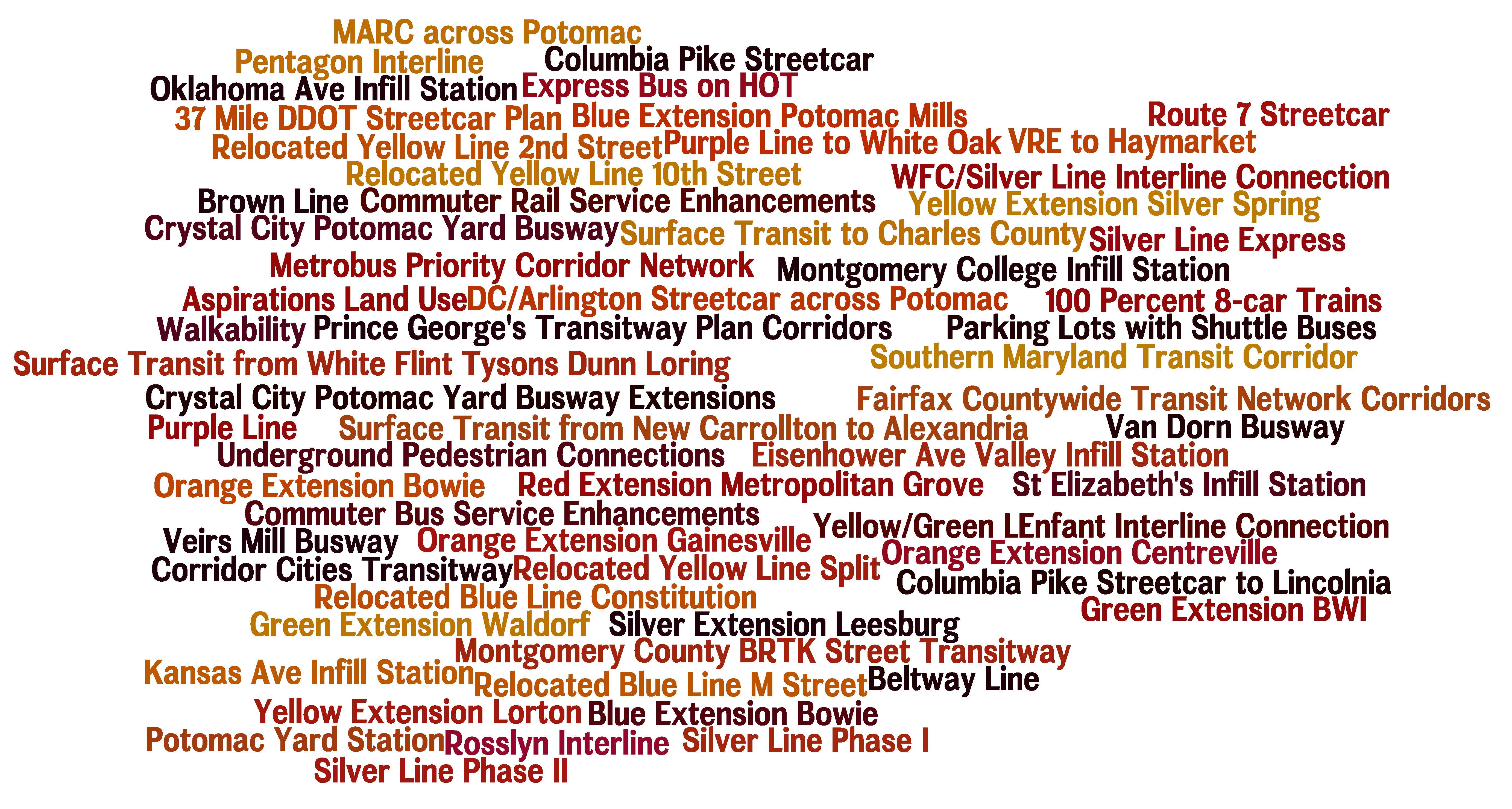
List of Transit Corridors, Projects, and Plans Analyzed as Part of RTSP
We have received tons of great comments on the proposed 2040 network of Metrorail and high capacity surface transit corridors. Many of you have said that we missed <insert corridor here> or have asked why we don’t have a line to <insert address here>. As part of this plan, we have analyzed almost every corridor or mode that you have identified. However, we recognize that most of it was behind the scenes and is buried deep in our posted presentations to the Technical Advisory Group (TAG).
Above is a list of what was analyzed before we unveiled the proposed 2040 Metrorail Network and regionally significant high capacity corridors. Better yet, here is a document that shows the Metrorail lines and other surface transit plans, projects, and strategies that were tested over the course of the project. Everything is listed and where possible, maps and graphics are provided to illustrate what was tested. All tested items were measured against a comprehensive set of measures of effectiveness (MOE). The MOEs assessed ridership, impact on core capacity, transfers, reduction in vehicle miles traveled (VMT), mode share, etc.
To wet your whistle, below, check out the Beltway Line that was tested. Only the segments that crossed the American Legion Bridge (between White Flint and Dunn Loring) and the Woodrow Wilson Bridge (between Branch Avenue and Eisenhower Avenue) had some promise and therefore, they continued on in the analysis, though as surface transit not Metrorail. The other segments did not provide good ridership, primarily due to the low densities within a walkable distance from the Beltway, and had little impact on Metrorail core capacity.
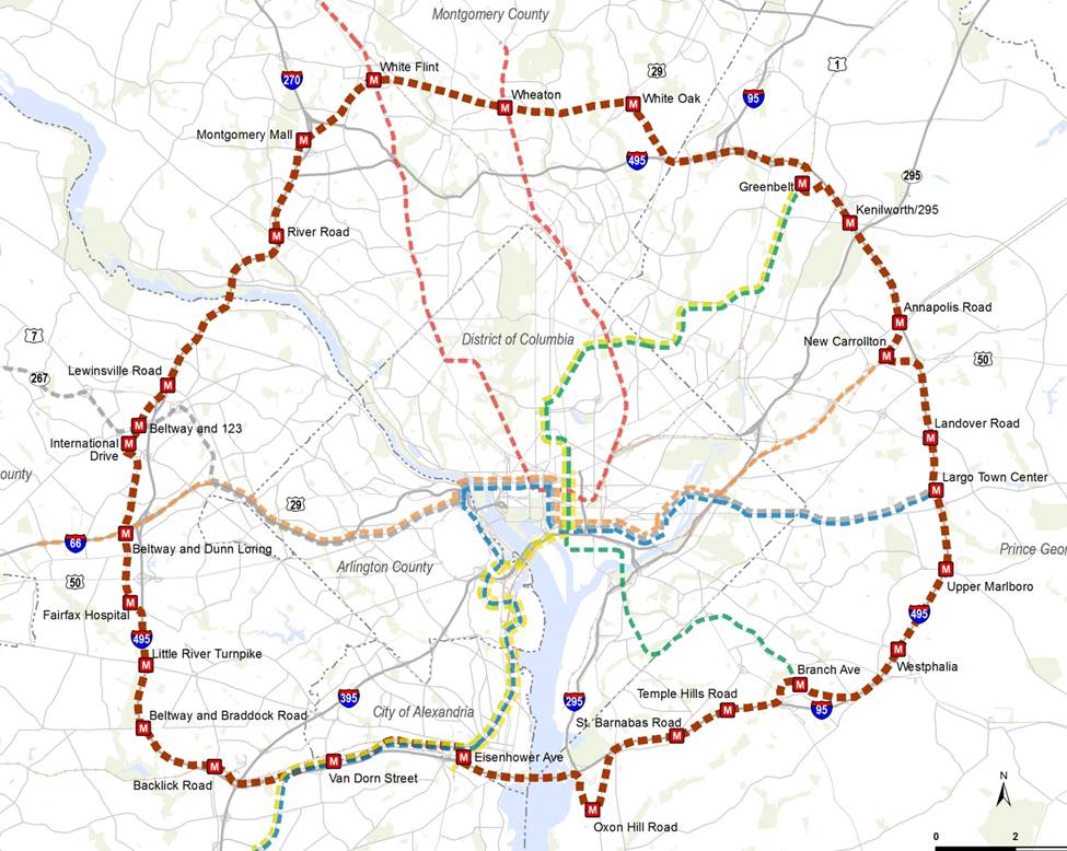
Alignment of a Beltway Line that was tested in the RTSP
Let us know what you think!

Makes sense. Who knows maybe in 50 years Metro will rethink a beltline but I can’t see the cost benefit analysis working out now. A rapid connection from Montgomery County to Fairfax would make a lot of sense. Priority bus corridor maybe? Also the planned purple line should provide a lot of the inner suburb mobility that a beltway line would be meant to improve.
An extension of the Orange Line to Fair Oaks Mall needs to be reviewed. The extension is mainly needed to improve traffic flow entering and leaving the end of the line station. Vienna is a terrible end of the line station. The road infrastructure cannot handle the traffic flow.
Fair Oaks Mall Metro will increase reverse flow Metro traffic on the orange line because it is already a commercial center and can be built with an inline highway BRT station below the metro platform.
@MCS
It has been! We looked at an extension of the Orange Line to Centreville and one to Haymarket (listed 10 lines from the bottom of the word cloud). The one to Centreville is one of our regionally significant high-capacity surface transit corridors - https://planitmetro.com/2013/12/19/more-than-metrorail-the-regions-most-important-high-capacity-surface-transit-corridors/.
@Ab
Thanks for thinking it makes sense, Ab. The Montgomery County - Fairfax County connection is one of our regionally significant high-capacity surface transit corridors - https://planitmetro.com/2013/12/19/more-than-metrorail-the-regions-most-important-high-capacity-surface-transit-corridors/.
Thanks for looking into an Eisenhower Valley infill station. There is a lot of room between Eisenhower and van Dorn that is, sadly, wholly underutilized at present. This area, however, could be one for huge growth opportunities because of its location: it’s on a good roadway with Fairfax to west and City of Alexandria to east; its on Blue line and Yellow is nearby; its right off the beltway. If all of the low rise commercial was upgraded and if the industrial uses were moved, this could be an explosive corridor for future City of Alexandria growth, although I recognize that’s focused on Potomac Yards right now.
It would be great to see the Greenline (Branch Avenue) extended thru Charles County on Route 5. It has been congested for years and with the addition of the Brandywine Crossing and several housing developments all along Route 5; it mean even more congestion and accidents. The long stretch from the District line to the Charles County line on Branch Avenue is only to lanes. What should be a seven (7) minute drive from Coventry Way (Rte 5 cross street) to the Southern Maryland Hospital can take up to 45 minutes with an accident. Thanks.
@shirley clay I AGREE. Green line needs to run into Clinton, and down into Charles County( acokeek,indian head).
Can you explain why the proposed “Brown Line” (from Friendship Heights to Cherry Hill Road isn’t getting more consideration? It seems like it would hit all of your requirements such as providing more core capacity for other lines, hitting areas with high (or relatively high) densities, and most importantly - reduction in vehicular traffic.
Thanks!
Well its already been stated the method which metro uses to figure out ridership is flawed.
EVERYone wants the metro to at least woodbridge.
Look at the traffic on I95 North, and the toll lanes ARE NOT going to fix it nor will BRT its all Bandaids.
The fact we have the ability to bring the yellow line down route one threw lorton to meet the blue line going on the csx right away to the VRE woodbridge state area would make the are much more better. IT would bring more people to this area, and more ridership.
A connection to allow trains to go to Springfield from the yellow line south and blueline to turn north onto the yellow without going to the final woodbridge stop would even allow even more service options.
Im currently making up a pdf to send to Prince william county and fairfax along with the local reps.
I have a hard time understanding this argument against building a Beltway-line: “The other segments did not provide good ridership, primarily due to the low densities within a walkable distance from the Beltway, and had little impact on Metrorail core capacity.” I can understand that it does little for the Core, but what it does do is provide suburb-to-suburb capabilities. It is possible someone from New Carrolton would like to get to Rockville without going through the city. Rockville is (relatively) high-density, and New Carrolton isn’t, but it’s easy to see someone driving there and parking. All the places that are low-density, that you don’t think would “provide good ridership,” would be drive-to metro stations, taking people to job centers in the dense centers in NoVA and MontCo.
I’d really like to see the methodology used to determine this plan isn’t worth pursuing.