
RTSP Evaluating and Prioritizing Corridors for High Capacity Transit: Dispatch from TAG Meeting #10
This is the second post in a two-part series based ![]() on content from the tenth meeting with the Regional Transit System Plan (RTSP) Technical Advisory Group (TAG) that was held in July. The first post focused on our analysis of new Metrorail lines in the core and Virginia. This post is about our approach to identify regionally significant corridors for high capacity transit.
on content from the tenth meeting with the Regional Transit System Plan (RTSP) Technical Advisory Group (TAG) that was held in July. The first post focused on our analysis of new Metrorail lines in the core and Virginia. This post is about our approach to identify regionally significant corridors for high capacity transit.
By 2040, multiple regionally significant travel corridors will need high capacity, high frequency transit to connect people and jobs outside of the core.
As part of the RTSP, we will identify regionally significant corridors where transit priority infrastructure is needed to provide high capacity transit. At the TAG meeting, Metro Planning staff presented a methodology to identify, evaluate, and prioritize these regionally significant corridors. The methodology has evolved since the July meeting and is described below. The actual evaluation and prioritization is still in process.
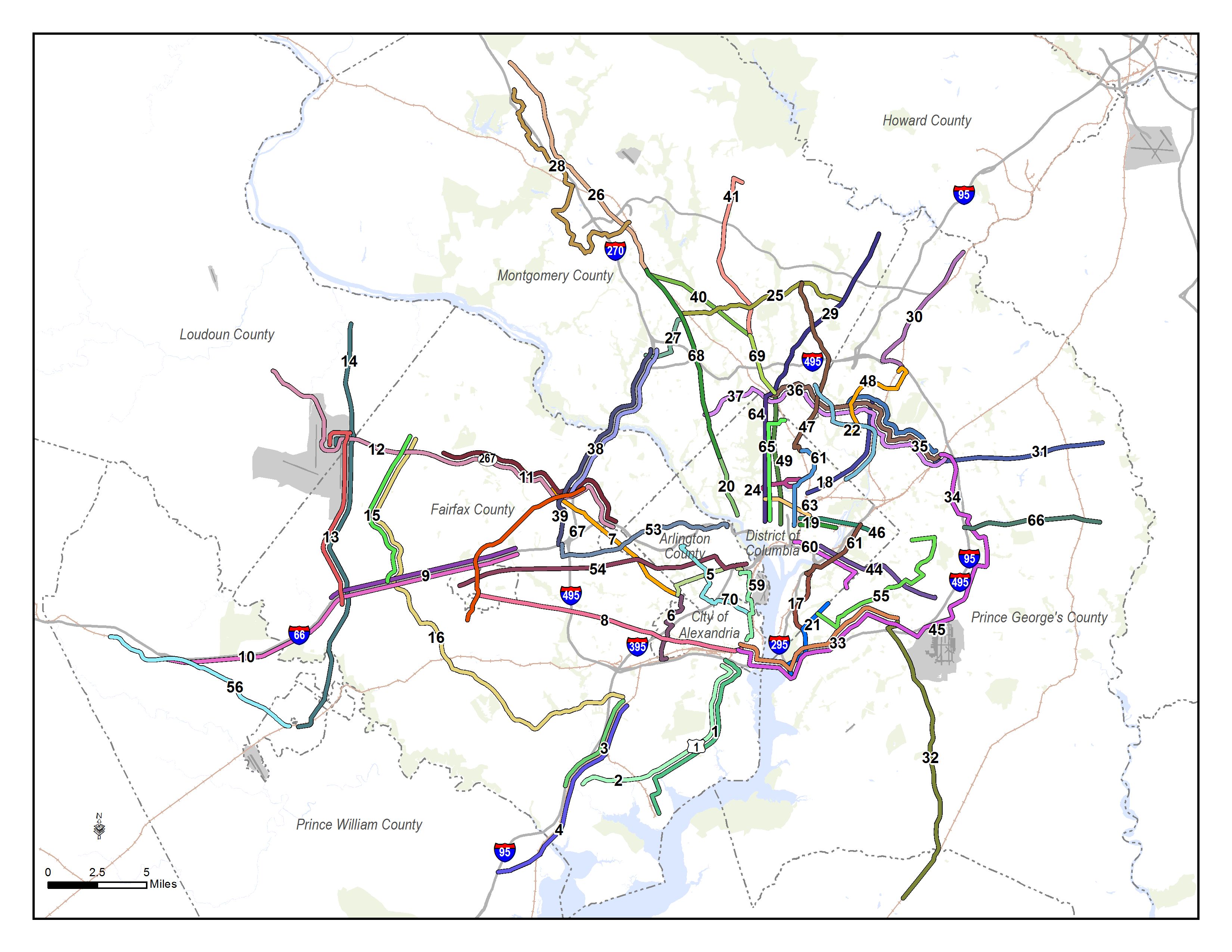
Corridors identified for evaluation for high capacity transit.
Since the TAG meeting, we have also conducted one-on-one meetings with each jurisdiction and agency in the RTSP study area to review and gather feedback on the full set of corridors that will be evaluated. Approximately 70 corridors have been identified from:
- The region’s Constrained Long Range Plan,
- Metro’s own Priority Corridor Network,
- Local jurisdictions’ long range plans,
- Extensions from end-of-line Metro stations, and
- New connections that Metro’s planners felt were not included in the above.
These corridors will be evaluated based on the following elements:
- 2040 employment forecasts within a ½ mile buffer of the corridor
- 2040 household forecasts within a ½ mile buffer of the corridor
- Boardings per mile from the scenarios
- Number of regional activity centers per mile
Based on the evaluation, the corridors will be prioritized into three tiers. The tiers are defined as follows:
- Tier 1: CLRP and PCN corridors, which the region has indicated are the most viable for high capacity transit implementation in the near to mid-term
- Tier 2: Corridors where projected land use and ridership potential demonstrate their regional significance and opportunity for transit priority, but are unfunded for capital improvements to ensure high-capacity transit operations.
- Tier 3: Corridors where projected land use and ridership do not indicate that they would be supportive of high capacity transit by 2040. However, in the future, they may be viable if supportive planning and policy actions are implemented.
Tier 1 and Tier 2 corridors will be identified in the 2040 network as high-capacity transit corridors, while those in Tier 3 will continue to be modeled with local or enhance bus service, unless a locally preferred alternative has been identified. These corridors, along with the proposed Metrorail network outlined in the previous post, will be combined to create the 2040 regional transit network.
For more information on scenario descriptions, measured results, and key findings download meeting materials: TAG 10 Presentation.

How does this plan coordinate with the Baltimore area? In what plan are the corridors between Northern PG & Montgomery to Baltimore?