Author Archive

Bike and Pedestrian Infrastructure – Quantifying the Return on Investment

September 26th, 2016 Comments off

Sometimes small investments yield large returns. Building sidewalks and bike lanes to Metrorail stations increases safety and pays off two to one.

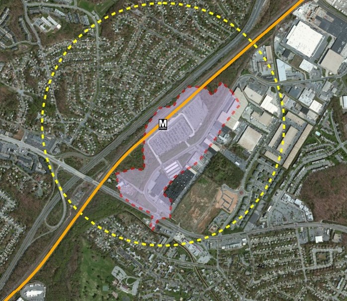
To close the loop on the last post that described our station area bike/ped project selection and evaluation process, we’ve posted the summary report online for your reading pleasure.   To skip right to the bottom line, though, we’ve been able to tie dollar amounts to certain project benefits and have calculated a total return on investment that’s nothing to sneeze at.   In short, we’ve estimated that a $13 M investment in some of the 394 top pedestrian projects leads to a $24M discounted revenue impact for Metro and its funders of the course of these projects’ useful life, a net positive benefit of $11M.  BAM!

MSIS Report Cover

In addition to the monetary returns, there are a number of other benefits that tend are challenging to quantify financially but have great value to customers and society at large.   For example:

  • New pathways shortens someone’s travel time, making Metro a more attractive option for the trip they are making;
  • New sidewalks may open up the station to an ADA customer who had to rely paratransit before to get to where s/he was going; and
  • New bike lanes provides a separation between both moving and parked cars, and the bicyclist, making her safer.

These projects are valuable indeed and the task before us (the royal ‘us’) is to ensure that they are built, thereby contributing to a more efficient use of the Metro system by maximizing the accessibility of stations.  So, let’s get cracking!

Since we collected projects from planning documents going back a few years, we anticipated that some of them might already have been built or might no longer work in the current context.  Therefore, we asked staff from our local transportation departments and planning agencies to help us “ground-truth” or update project status.  Out of the 394 top projects, we removed 194 that were already completed, no longer under consideration or that have already been funded, leaving 200 to focus on.

Not bad for a day’s work!

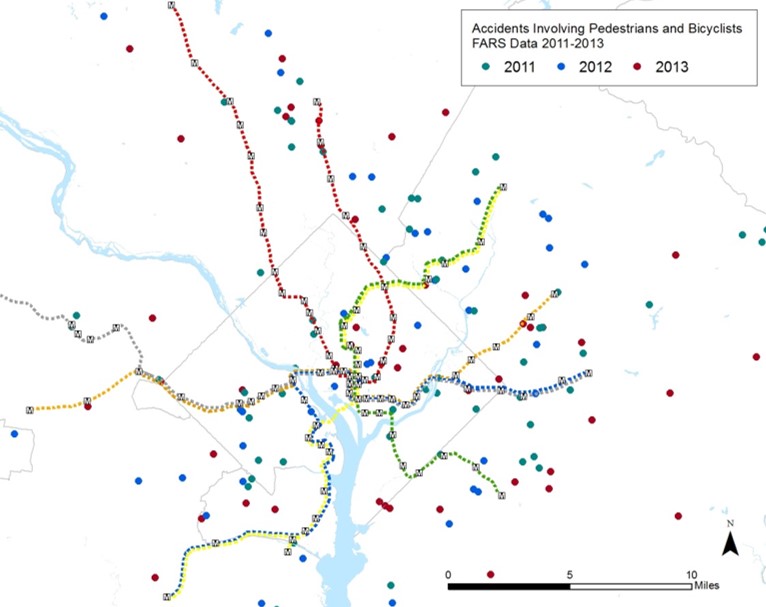
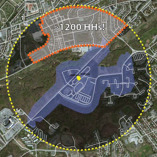
The summary report includes maps showing where the most-needed projects are located, as well as a “scorecard” detailing each project’s potential benefits as calculated in the prioritization process.  These include the safety measure defined by frequency of crashes proximate to the project, the potential ridership generated for certain projects, community facilities served, whether or not the project is located in a low income area (and, if so, how much of it falls in that area), the Walkscore, estimated cost, and a number of other useful indicators.

Read more…

Pledge to Go “Car Free” on September 22!

September 19th, 2016 Comments off

Planning to Walk, Bike, Telework or Take Metro on September 22?  Then take the pledge to go Car Free.

Car Free Day is this Thursday, September 22.  Any of us who live or work in the Washington region can pledge to go Car Free or “Car Lite” (meaning some access to a car or van pool) to help raise awareness  about alternative modes of travel relative to driving alone.  In addition to showing your support for a good cause, you might even win a prize.

Interest in Car Free Day is widespread, from folks who don’t even own cars (see our post from a few years ago) to folks who typically drive alone to work and may need a little encouragement to try something else.  Last year, more than 3,500 people pledged to go car free in the region.  About 38% said they would bike, 22% would take rail, and 17% said they would use a bus as their primary mode of transportation.  As with Bike to Work Day, events like Car Free Day can have a lasting impact beyond the one-day event by leading people to make changes in the ways they choose to get around.  So help bring up this year’s number of pledges by signing up today.

Prioritizing Bike and Pedestrian Station Access Projects Near Metrorail, Part 2

November 24th, 2015 Comments off

Other than ridership potential, what are some of the other ways we can rank access projects relative to each other?

In our last post, we discussed how bike and pedestrian access projects relate back to ridership and how that relationship could be used to prioritize projects. In this post, we talk about some of the other criteria we are using to prioritize projects.

Bike and Ped. Fatalities, Sample Data Set

Bike and Pedestrian Fatalities, Sample Data Set

The first is safety. We are pulling together data about bike and pedestrian crashes near our stations that result in injuries or fatalities. We will then link these data in GIS back to the location the project, with the idea being that a new crosswalk or dedicated bike path in an area with a lot of recent crashes should score higher and deserves more attention. A safer path of travel helps not only our customers but all walkers and cyclists in these areas.

We also want to explore some other prioritization criteria. Here is what we have come up with: Read more…

Prioritizing Bike and Pedestrian Station Access Projects Near Metrorail

November 1st, 2015 Comments off

We all know improving station access is good.  But, how do we rank access projects relative to each other?   Step 1: Ridership

In our recent post, we gave you an overview of our Station Access Investment Strategy project.  We’ve identified 1,000s of recommendations for new pedestrian and bicycle infrastructure near our Metrorail stations and need a way to prioritize them.  After some thought, we’ve come up with a number of potential criteria.  In this post, we’ll discuss those that deal with ridership.

July 2014 Post on Ridership Potential from New Ped./ Bike Projects

Map of the Southern Ave walk shed from July 2014 Post on Ridership Potential from New Ped./ Bike Projects

Once again, one of key concepts we’ve been telling you about in recent months is that by improving access to stations we can grow ridership.  For stations with relatively small walk sheds, we’ll conduct a detailed analysis of what happens to the walk shed when the proposed projects are built.  For example, add a sidewalk at Cheverly and the walk shed will grow by X%.  We will then look at the amount of households and jobs in the newly connected area and, using some methods we’ve shown you in other posts, calculate the potential ridership gained by the new project.  The higher the potential ridership gain, the better the project scores.

But, we also want to understand the value of a new project to a part of the station that is already connected to the network and how this could relate back to ridership.  To do this, we’ve come up some other metrics.  They include: Read more…

Metro Studying Ways to Improve Bike/Ped Access to Stations

October 7th, 2015 Comments off

Improving walk and bike access is a cost effective way to increase ridership and improve the efficiency of the Metrorail network.   Where are these improvements needed and how should we (as a region) prioritize them?

Landover Walkshed

What projects might increase the size of the walk shed of the Landover Metrorail station?

In a number of earlier posts starting last summer, we’ve discussed the concept of walk sheds and explored the relationship between walkability, land use, and Metrorail ridership.  One conclusion of this effort:  grow the size of the walk shed and you’ll grow ridership.

Generally, we only have control over what happens on our own property.  While we have made great strides in identifying and prioritizing bike/ped access improvements on our own property, increasing the size of the walk sheds requires coordination with state or local agencies who own, plan, design and construct roads, sidewalks and pathways near our stations.  We know that in order to have a larger impact on walk and bike access, we need to cast a wider net and identify projects that are up to one mile from our station entrance.  We have created a plan — the Station Access Investment Strategy — to highlight some of these projects as priorities for our local partners to use as they develop their capital improvement plans. Read more…

REMINDER: Go Car-Free Tomorrow! (and maybe the rest of the week, for that matter)

September 21st, 2015 Comments off

Pledge to go car free this week!

Tomorrow, Tuesday, September 22, marks the 8th year International Car-Free Day has been celebrated here in this region. If you haven’t taken the pledge to leave the car at home tomorrow, there’s still time!  Sign yourself up for the car-free mode of your choice.  Not only will you save some carbon (find out how much using our Greenhouse Gas Calculator), but you also just might win yourself a nifty prize.

Car Free Day PosterCar Free Day banner 2

Further, given that the Papal visit will occur from Tuesday through Thursday this week, you may want to sign up mentally for another few days of a car-free lifestyle and avoid major congestion around town.

Let us know how you’re going car-free in the comments.

Survey Analysis Details Non-Work Trips on Metrorail

December 17th, 2013 10 comments

Almost one in five trips on Metrorail are NOT work-related. Who is making these trips, and where and why are they making them?

Woodley Park-Zoo 042511-131

Metrorail is how many of us in the region get to work.  But, as we will illustrate below, many of us also use it to do other things.

Using data from the 2012 Metrorail Passenger Survey, we were able to determine that about 125,000 or 17% trips on an average weekday do not involve travel either to or from ones’ place of work.   This is virtually identical to the results from the 2007 survey.  In order to understand how people use the system for non-work trips, we sorted out everyone who is either going to or coming from work from everyone else.    For example, a trip stopping off at the store after work would not be counted; however, a trip starting out at home and traveling to school would be counted.  In terms of where these non-work trips are going, most are returning home followed by “personal trip” and “shopping or meal.”  

Work-Non-Work-Pies-01

Read more…

Next Generation Communications

July 19th, 2013 Comments off

A next generation communications PIDSsystem would expand current communications infrastructure to provide an integrated one-stop communications hub for the region’s transit customers. Proposed improvements will capitalize on efforts already underway to improve the functionality of the rail control software. They include the next generation of the Passenger Information Display System (PIDS), new public address systems, improved station signage, and equipping station managers with mobile devices. Bus and train information will also be integrated, with real-time information displays to well-used bus stops.

Read more…

Come Learn About the Silver Line

March 4th, 2013 8 comments

Come learn about the new Silver Line next week

Come learn about the new Silver Line this week and next

Join us for a series of community events to learn about service improvements to bus and rail coming along with the new Silver Line service to Tysons Corner and Reston.  We will be on-hand to discuss what the new service means to you, including changes to the Orange and Blue Lines, and local buses.

The “main event” will be three Open Houses which will feature informational exhibits on rail and bus service, a table where we will be collecting public feedback, a section for children’s activities as well as a “WMATA tools section” where folks can learn about Next Bus, sign-up for e-Alerts and get other useful information. Here’s the schedule and locations:

–      Tuesday, March 12, 5-8p at Faith Temple #2 Baptist Church, 211 Maryland Park Drive, Capitol Hgts., MD 20743 (walk from Capitol Heights Metrorail station, Metrobus 96 or 97)

–      Thursday, March 14, 5-8p at the Reston Community Center Hunters Woods, 2310 Colts Neck Road, Reston, VA 20191 (Fairfax Connector: RIBS 1/3, RIBS 2 & Route 551)

–      Saturday, March 16, 11a-4p at the Sheraton Crystal City, 1800 Jefferson Davis Highway, Arlington, VA  22202 (walk from Crystal City Metrorail station, Metrobus 9A, 9E, 9S, 10A, 10E)

Prior to the Open Houses, we will host a series of smaller events or “Pop-Ups” this week in the community.   At each of these, we’ll be stationed at a table to answer your questions, provide information and give you a chance to provide us your feedback.  Here’s the schedule and locations for these events:

–      March 5, 4-6p at Largo Town Center Metro

–      March 7, 4-6p at West Falls Church Metro

–      March 8, 10a-2p at Tysons Corner Center Mall I (on the first floor near Barnes & Noble)

–      March  8, 4-6p at Pentagon City Metro

–      March 9, 10a-2p at the Eden Center (6751 Wilson Blvd, Falls Church, VA 22044)

The public comment period will run from February 28 through March 18, 2013.  You may submit your comments at the events or online on the project’s website, wmata.com/silverline.

Identifying & Funding Pedestrian and Bicycle Project Needs

December 22nd, 2011 7 comments

Back in August, we posted information about our latest endeavors to improve bike and walk access to Metrorail.  We have since completed our field work and now have a laundry list of more than 3,000 individual projects throughout the Metrorail system that we identified through that effort.  The projects range from the small and simple (e.g., Vienna racks) to the larger and more complex (e.g. additional Bike & Rides).  Metro’s Pedestrian and Bicycle Element of 2012-2017 Capital Improvement Program (1.1 MB, PDF) summarizes the findings by category, and provides an overview of the methodologies we employed to prioritize projects, as we identified a larger need than is currently funded.

And, although the  primary goal of this project is to provide a list of needed bike and pedestrian access projects to be funded through Metro’s Capital Improvement Program (CIP),  the list of needs developed in the inventory also will help better inform our partnerships on transit oriented development (TOD) and other projects near our stations.  Many of the projects improve the links from our station property to that of other property owners and will be instructive as stations undergo development transformations.

Project Highlights

Field teams were out evaluating conditions all over the system.  They highlighted desire lines to stations, bike parking needs, sidewalk & pathway improvements, intersection improvements and other pedestrian and bike needs.  Below are some high level summaries to give you a flavor of what we found out there:

Sidewalks and paths: Our field work identified hundreds of small sidewalk and pathway projects typically on Metro property that will improve access to our stations.  Each project tends to be small, say 200 to 500 feet long, but added together from end to end, they would stretch 10 miles.  Most of these projects are at suburban stations, where our entrances tend not to be directly located on the street network.

Intersection improvements: We looked at the intersections that serve our stations for places where new crosswalks, curb ramps, crossing islands or other improvements were needed and found 700 locations for such improvements.  Many of these are located off of our property on adjoining streets, so we plan to work with the local jurisdictions to address these.

Bike parking: More than 400 potential locations for future bike parking were identified, including the type and expected capacity of parking.  The field survey explored potential locations for additional Bike & Ride parking facilities and covers for bike racks.  Our plan is to build or reserve space for bike parking in the amounts needed to help us reach our mode share goals of 2.1% by 2020 and 3.5% by 2030.  To make these numbers work, we’ll continue to work with our local bike/ped planning partners to improve the on- and off-street connections to our stations so we can fill this bike parking.

Prioritizing Projects

So, 3000+ is a lot of projects.  We’d love to be able to do them all.  However, our funding is currently constrained.  So, what do we do? – we prioritize.  And, how do we do that?  We look to our Agency goals.  At the top of the list is safety & security, delivering quality service and using resources wisely.   We took a look at how our projects stacked up against these goals and created an action plan to complete the projects that best achieved them.  There are more details about the process in the attached document, but let it suffice to say we think we’ll make some real headway in meeting these goals and their accompanying objectives as we improve access to our stations.  In the meantime, if other funding opportunities crop up – say TIGER IV, or V, or XXXII – we’ll be ready to go.

Follow Along with Us

We have already begun work on the projects identified, and planning for more projects is underway.  As we complete projects we’ll continue to post them here.  Please let us know what you think.  Have they helped?  Are there other projects you see out there?

Update January 18, 2012: Maps of all project needs at by individual Metrorail station are available below. Due to the size of the files, we’ve posted them as 8 separate documents in alphabetical order by station name. They should be readable with Adobe Acrobat 6.0 or later:

  1. Addison Road-Seat Pleasant to Capitol South (PDF, 2.2 MB)
  2. Cheverly to Dunn Loring-Merrifield (PDF, 2.2 MB)
  3. Dupont Circle to Gallery Pl-Chinatown (PDF, 2.5 MB)
  4. Georgia Ave-Petworth to King Street (PDF, 6.0 MB)
  5. Landover to Metro Center (PDF, 1.2 MB)
  6. Minnesota Ave to New York Ave-Florida Ave-Gallaudet U (PDF, 7.0 MB)
  7. Pentagon City to Twinbrook (PDF, 3.2 MB)
  8. U St/African-Amer Civil War Memorial/Cardozo to Woodley Park-Zoo/Adams Morgan (PDF, 2.4 MB)