December 16th, 2015
Shyam

WMATA is excited to be part of “Friends with Transit”, Lyft‘s initiative to provide first and last mile connections to transit systems across the nation, and a coupon code.
Metro covers a lot of ground – 1,500 square miles or so! But not everyone is within convenient walking or biking distance to transit, and that makes us less convenient than we would like to be for our customers! We’ve profiled here how we would like to close that first-mile/last-mile gap for our customers through enhanced pedestrian and bicycle connections, and now we have yet another option to get you where you need to go. Read more…
Secretary Foxx has issued his direction that Metro cannot consider any new rail expansion right now, and WMATA agrees! So much so that we wrote it into our strategic plan back in 2013. Earlier this fall, the Prince William County’s Board of Supervisors heard from WMATA about the importance of fixing Metro’s core before considering any expansion.

The Silver Line’s Phase 2 extension from Wiehle-Reston East to Dulles Airport and Loudoun County could be the last for decades to come. (photo credit: Ryan Stavely, Flickr)
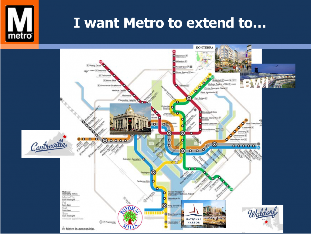
As the region grows, so does the pressure for extensions of Metrorail. The requests are frequent and common: “Extend Metro to BWI! to Centreville! to Waldorf! to Fort Belvoir!” We’ve heard and even modeled most of these requests. For a system that’s shaped and contributed tremendous economic value to the region, it only makes sense that communities outside of its immediate reach want improved access to it. WMATA Director of Planning Shyam Kannan recently took the opportunity to discuss the potential for the extension of Metrorail into Prince William County. With 80% of today’s Metrorail trips going to or through the system’s core (PDF), he noted that major core capacity improvements must be made prior to considering any additional rail extensions. While addressing core capacity has been a major part of Momentum, including initiatives like the 8-car train program, core stations, and New Blue Line Connections, the plan remains largely unfunded. With safety and state of good repair needs as Metro’s top priorities and core capacity relief put off indefinitely, any potential extensions (if they happen) are likely decades away from being built.
Read more…
Categories: Strategies Tags: BRT, commuter rail, core capacity, corridors, expansion, land use, LRT, Metro 2025, Metrorail, Momentum, policy, Streetcar, tod, transit-oriented development
The answers to these four questions will shape the future of Metro’s federal customers, and the region’s transportation future. (Fifth and last in a series of posts on Metro’s Federal customers – see posts 1, 2, 3, and 4)

The ATF headquarters adjacent to NoMa Metrorail station has helped grow ridership there significantly.
1. Will the transit benefit be restored to parity with parking? When Congress cut the transit benefit in half, it hurt Metro riders hard. 42% of Metro’s ridership – around 500,000 rail and bus trips per day – comes from riders who use the Federal Transit Benefit, including private-sector workers. At Metro, 22% of all ridership comes from commuters who spend over $130 per month on transit. Following the changes to the SmartBenefits program, Metro saw ridership losses concentrated on these riders hit the hardest, and federal employees overwhelmingly pay with SmartBenefits.
If Congress restores the maximum transit benefit to parity with parking, it would be a huge boon to Metro’s federal customers and Metro’s bottom line. Read more…
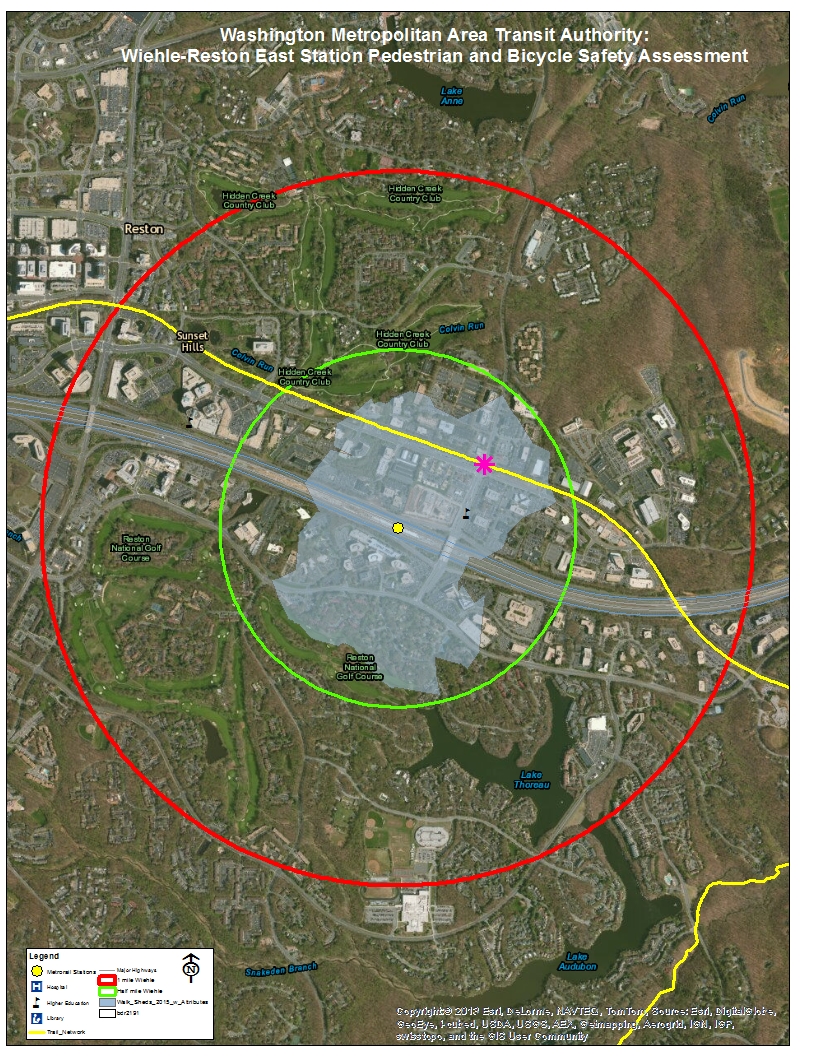
On May 12, 2015, the Federal Transit Administration (FTA) convened an event to bring together Federal, State, regional, and local transportation officials and local stakeholders for an on-the-ground bike-ped safety assessment at the Wiehle-Reston East Metrorail station.

Wiehle-Reston East: one mile bikeshed and 1/2 mile walkshed
The assessment was one of 50+ that have been occurring around the nation as part of U.S. Department of Transportation Secretary Anthony Foxx’s “Safer People Safer Streets” campaign to improve bike-ped safety across the country. These assessments have been led by many of the US DOT agencies and operating administrations, namely: Federal Highway Administration (FHWA), National Highway Traffic Safety Administration (NHTSA), Federal Transit Administration (FTA), Federal Motor Carriers Safety Administration (FMCSA), and the Federal Railroad Administration (FRA). Each of these agencies is participating in the effort to improve bicycling and pedestrian safety, and each has particular roles and responsibilities in this effort.
The primary goal of these assessments is to:
- facilitate relationship-building between employees of different jurisdictions who share responsibility for creating safer streets;
- engage practitioners who typically focus on pedestrian and bicycle safety, as well as those who do not; and
- focus on locations that have non-motorized safety challenges.
The assessment kicked-off with remarks from Deputy Secretary, Victor Mendez, who stressed the importance of agency coordination in ensuring bicycle and pedestrian safety on America’s streets, later blogging about the event on US DOT’s FastLane blog. Metro’s Director of Planning, Shyam Kannan, also gave remarks that highlighted the importance of station connectivity for increasing Metrorail ridership. Other VIPs from Fairfax County, Virginia Department of Transportation (VDOT) and local community/advocacy groups spoke to the participants as well about the importance of the day’s events to keeping our residents safe as they travel. Read more…
In part one of this series, Metro Planners led a session at StreetsCamp Saturday June 20, 2015 to talk with transit advocates about other possibilities beyond Metrorail to increase transit use, reach, and access.
Politicians and citizens always ask for more Metrorail, but why should transit continue to chase land use decisions? Metro Planners Allison Davis and Kristin Haldeman talked to transit advocates and urbanists at StreetsCamp last Saturday to provide approaches that can help the transit we have today reach more people and be more cost-effective without requiring more Metrorail (pdf). The major take-aways for advocates and urbanists were to advocate for:
(1) Local decision makers to monetize full life‐cycle cost of land use options;
(2) Access projects that create comfortable (i.e. desirable) paths for pedestrians and bicyclists; and
(3) Local jurisdictions to add transit signal priority, queue jumps, and bus lanes
Why these three specifically? Read more…
Categories: In The News Tags: access, benefits, bus, business case, capacity, Metrobus, Metrorail, pedestrian, planning, plans, presentations, streetscamp, studies
Fairfax County seeks input from bike-and-ride commuters.
 As we have discussed previously, safe and convenient pedestrian and bicycle access is critical to Metro’s success, and WMATA works closely with local jurisdictions to find ways to improve conditions for customers arriving on foot or bike. Compared with the high expense of building more parking garages for park-and-ride customers, investing in better walking and biking infrastructure is an incredibly cost-effective way of attracting Metro customers. On Metro station property, WMATA is making investments such as bike parking and path improvements. On the public streets beyond, our local and state partners are installing their own new facilities for people walking/biking to the station. Read more…
Metro’s planners provide tips on avoiding crowds this Cherry Blossom season.
After this long and trying Washington winter, locals and visitors alike are marking their calendars for the 2015 Cherry Blossom Festival. While everyone knows that Metro is the best way to reach the blossoms, PlanItMetro has been digging into the data to help you minimize the crowd crush and maximize your enjoyment of this treasured DC celebration.
What happens to Metro ridership? As we showed last year, the Cherry Blossoms always bring a major bump to Metrorail ridership, especially on weekends and at Smithsonian station. Metro is ready for the increased demand: track work is cancelled, service levels are increased, and our customer ambassadors are out in the field to help with the needs of visitors. So how do savvy Washingtonians avoid the thickest crowds?
Tip #1: Avoid Smithsonian station

On weekends during Cherry Blossoms, the number of customers exiting Metro at Smithsonian dwarfs every other station during daylight hours
Read more…
Making every Metrorail station area walkable could reduce regional congestion without breaking the bank.
This is part three of a three-part series.
In the previous two posts we’ve laid out a case for making all transit stations walkable as quickly as possible.
- Increasing walkability and density at station areas has huge impacts on transit mode share and can take tens of thousands of cars of the road every single day.
- At a regional level, walkable station areas have an equivalent impact on congestion as a quarter trillion dollars in “last mile” infrastructure (see pages 37, 38, 43, 48).
Maximizing the capacity of the existing transit network while intelligently investing in station area connectivity would combat regional congestion just as effectively as trying to “build our way out of the problem”. And unlike many potential interventions, the market actually wants to do this for us.
Perhaps it is time to harness these market forces to make the areas around our transit network walkable and implement this low-cost congestion-busting paradigm. As for where to begin – well, we have a few suggestions…
Existing Walkability Near Metrorail Stations
The map below shows the range of existing walkability conditions near the Metrorail network and helps answer the question of how much of a half-mile radius of each station a person can walk to. The higher the percentage, the better the pedestrian network coverage. As shown, many of the station areas are under performing relative to their potential walkability. If walkability = connectivity and connectivity = mode share, then just imagine the impact on the region’s roads if we could focus on taking station areas with low accessibility and invest in some relatively easy, short-term solutions like sidewalks, pedestrian bridges, crosswalks, and smart, transit-oriented development to take maximum advantage of the existing Metrorail system and take tens of thousands of cars off the road each day.
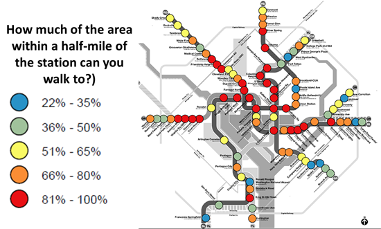
How much of the area within a half-mile of our Metrorail stations can you walk to?
Read more…
Improving pedestrian connectivity takes cars off the road at a formidable clip – rivaling the power of all of the region’s planned roadway additions and “last mile” transit connections. Cheaply and quickly.
This post is part two of a three-part series.
The data is finally in, and we now know that walkable station areas result in fewer motorized trips, fewer miles driven, fewer cars owned, and fewer hours spent traveling. And when we improve the pedestrian and bicycle access and connectivity to Metrorail station areas, ridership goes up, putting a major dent in congestion by taking trips off the roadways. Earlier, we discussed what it means to build walkable station areas and research shows the tremendous benefits to the region of making this a priority.
First, our data confirms that when walking access to transit is improved, transit ridership goes up – way up. In the 2040 Regional Transit System Plan (RTSP), we stress tested TPB’s transportation model to improve walkability to the transit network and saw huge increases in transit linked trips. These trips go up by about 10% region-wide and we get an increase in transit mode share for all regional trips by 0.5%. That’s over and above the roughly one percent increase in mode share we anticipate occurring as a result of building the entirety of the CLRP, an impact about half that of constructing all of that transit.
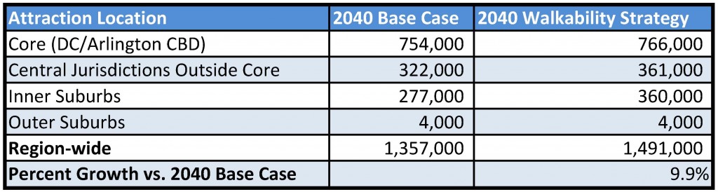
Source: Regional Transit System Plan
Read more…
When it comes to impacting weekday Metro ridership, meteorologists are three times more powerful than the federal government.
Many factors influence Metrorail ridership, including the weather and the status of the federal government. As this assessment shows, extreme weather has a much bigger impact on Metrorail usage than the federal government closure for budget reasons.
In the past few months, the federal workforce was instructed to stay home for two different reasons. The first was the failed budget negotiation that resulted in the federal government shutdown in October of 2013. (We’ll call this “shutdown closure.”) The second was the winter weather forecast that closed federal offices in the Washington region. (Let’s call this “snow closure.”) These two separate government closures have had different impacts on Metrorail ridership.
First, take ridership by time of day. The graph below shows ridership by fifteen-minute interval for three days. The tallest, green line is the average of weekday entries. The other two are days that the federal government was closed due to the shutdown (Oct 8, 2013) and snow (Dec 10, 2013). Now, the purple line illustrates the ridership due to the budgetary shutdown in October 2013 and the blue line shows ridership on a federal snow day in December 2013. The purple line (budget shutdown) is not dissimilar to the green (average), but the purple line (snow shutdown) illustrates a huge ridership drop. Why would this be?
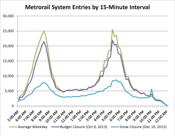
Metrorail ridership on an average day and two days the federal government was shut down. October 8, 2013 was part of the budget shutdown. December 10 2013 the fed was closed due to snow.
We can think of a few reasons for this difference.
- The budget shutdown only impacted SOME federal workers, i.e. those not deemed essential. Snow, however, impacts just about everyone.
- On snow days, area schools are often closed. Parents who have the luxury to do so sometimes stay home to look after their children who would otherwise be in school. Critically, parents who may be limited in child care options – many of whom are our customers – are especially vulnerable and often are forced to stay home because of the school closures.
- Washington is gradually evolving from a federal “company town” into a “boom town of the new economy,” a new economy less reliant on the federal government. Many of the businesses of the “new economy” were unaffected by the budget shutdown, but during extreme weather events take their cue from the federal government and give their employees the day off. According to Dr. Stephen Fuller of GMU’s Center for Regional Analysis, the Washington region is and will be “increasingly less dependent on federal spending as the driver of job growth and income generation in the local economy.”
Next, let’s look at change in ridership by station. Below are maps showing the change in ridership between a regular day and one of the government shutdown days: first budget shutdown and then snow shutdown. Read more…


Recent Comments