Posts Tagged ‘Connecting Communities’

Partnering to Go the Extra Mile (and every mile in between!)

December 16th, 2015 Comments off

WMATA is excited to be part of “Friends with Transit”, Lyft‘s initiative to provide first and last mile connections to transit systems across the nation, and a coupon code.

Metro covers a lot of ground – 1,500 square miles or so!  But not everyone is within convenient walking or biking distance to transit, and that makes us less convenient than we would like to be for our customers!  We’ve profiled here how we would like to close that first-mile/last-mile gap for our customers through enhanced pedestrian and bicycle connections, and now we have yet another option to get you where you need to go. Read more…

Transit Walk Sheds and Ridership

August 11th, 2014 11 comments

Metro cares about transit walk sheds because more households accessible to transit by walking translates directly into more ridership.

We’ve been focusing a lot on transit walk sheds lately. We’ve shown that the size of a transit walk shed depends heavily on the roadway network and pedestrian infrastructure, and that these sizes vary dramatically by Metrorail station. We’ve also demonstrated that expanding the walkable area can make hundreds of households walkable to transit.

But why do we care so much about walk sheds? Because larger walk sheds mean more households in the walk shed, and that means ridership. For example, we’d be hard pressed to find many households in Landover’s small walk shed, so it’s no surprise that walk ridership at that station is low. On the other hand, thousands of households are within a reasonable walk to Takoma’s larger walk shed, and walk ridership there is much higher.

In other words, the more people can walk to transit, the more people do walk to transit – and data across Metrorail stations prove it:

Correlation between Households in the half-mile walk shed, and AM Peak ridership, by WMATA Metrorail station entrance

More households in the walkable area around a Metrorail station means higher ridership

Read more…

What’s the Ideal Size for a Transit Walkshed?

July 8th, 2014 2 comments

Large transit walksheds are great, but how big is big enough?

In other posts, we have described what a transit walkshed is, and how changes can be made to the pedestrian network to increase the walkshed area.  Here, we explore how big is big enough.

The diagram below shows a half-mile circle around a transit station.  If the station were located in a field of grass or on a massive parking lot, the walkable area of the circle would be the circle itself, 100% of the half-mile buffer around the station would be accessible by foot.  Unfortunately, that wouldn’t bode well for transit use, since there wouldn’t be any origins or destinations within that walking distance.

Ideal Walkshed Diagram
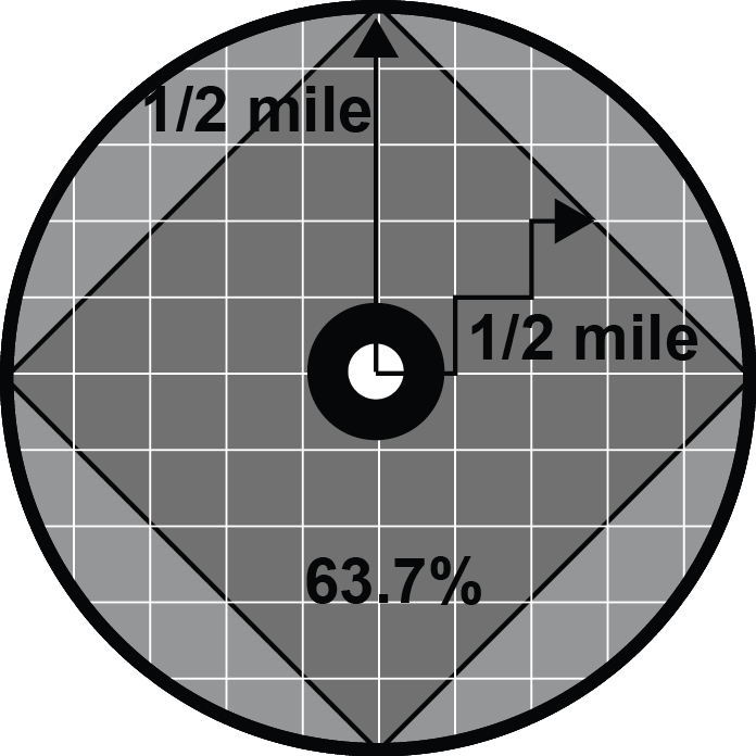
Now, let’s lay a perfect grid of streets across that half-mile buffer.  The street area is where people can walk, and the remaining area contains houses, shops, mixed-use development, etc.  The resulting walkshed for the station begins to look like a diamond inscribed inside the circle.   The smaller the blocks (the closer the streets are to one another) the more the walkshed resembles a perfect diamond that has a diagonal distance equal to the diameter of the circle.  If you take the area of the diamond and that of the circle and compare them, you find the walkshed (square) covers 63.7% of the circular station area buffer.

So if you have a perfect grid and get 63.7% coverage, how can you get any better?  For one, diagonal streets can increase the coverage: if two diagonal streets were added to the grid, intersecting in the center of the circle at the transit station, the square walkshed would turn into an eight-pointed star, increasing coverage even more, but not by much.

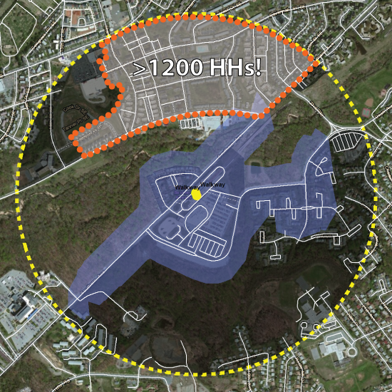
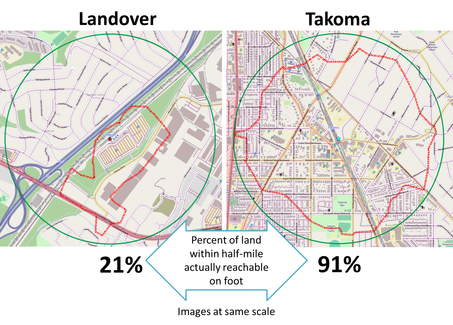
An good example of a walkshed greater than 63.7% is that of the Takoma station.  Featured in a previous post, we recently calculated a 91% coverage for Takoma.

It is difficult to pick an ideal size for a transit walkshed.    A larger percentage could be beneficial, but the additional roadway network needed to expand the coverage beyond 63.7% may result in less area dedicated to potential transit origins and destinations.  (Remember the station in the parking lot?)

What Metrorail stations do you feel have good walkshed coverage?  In  your opinion, where can we improve?


How Can The Coverage of Transit Walk Sheds Be Increased?

July 1st, 2014 2 comments

Pedestrian infrastructure can cost-effectively increase coverage of transit walk sheds.

The roadway networks of most station areas are mostly unchangeable.  Existing structures on private property create unmovable barriers and  usually prevent new roads from being added to the network.  However, there is still opportunity to add pedestrian facilities that would increase a station’s walk shed in a relatively cost-effective way.

Take the example of Southern Ave Metrorail station.  We previously noted how a large number of customers drive to the station from between one and three miles away.  We discussed several reasons for this tendency to drive to Southern Ave, including the proximity to parks on both sides of the station.  The map below shows the transit walk shed of Southern Ave station.

Current walkshed of Southern Ave station.  The area with the orange dotted border contains over 1,200 households that could be within a half mile of Metrorail if a direct pedestrian connection were built.

Current walkshed of Southern Ave station. The area with the orange dotted border contains over 1,200 households that could be within a half mile of Metrorail if a direct pedestrian connection were built.


But what if a pedestrian path could be built to connect the station to the neighborhood to the north?

If a well lit, safe pedestrian path were constructed between the station and the orange-dotted area on the map, it could expand the walkshed to include up to 1,200 additional households in DC.  This new connection would likely increase ridership at Southern Ave. and might even generate enough additional fare revenue to fund the construction of the trail.

Metro’s Office of Planning is currently evaluating the walk sheds of our rail transit stations.  What other opportunities do you see for cost-effectively increasing the walk sheds around Metrorail stations?

What’s a Transit “Walk Shed”?

June 10th, 2014 6 comments

Metro will soon be measuring how much growth happens in places that are walkable to transit. Here’s an in-depth look at how we define “walkable” to Metrorail stations and Metrobus stops.

Quarter-mile walk (by the network) for regional Metrobus stops and Metrorail stations

Areas reachable on foot from regional Metrobus stops and Metrorail stations

Metro’s new Connecting Communities metric will measure annual household growth in our region that occurs within the “transit shed” – the catchment area around transit service that generates walk ridership. And improving walkability can be an incredibly cost-effective way to reduce congestion and increase transit ridership.  Let’s take a closer look at how we defined what’s “walkable to transit.”

How Far is Walkable? First, we defined walking distance as a half-mile from Metrorail, and a quarter-mile from Metrobus, for a number of reasons:

  1. Of all the passengers who walk to Metrorail each morning, the median walking distance is just under a half-mile (0.35 miles, actually).  Riders walk farther to some stations than others, but the systemwide average is just shy of a half-mile.  Since rail riders are on average willing to walk a little under a half-mile today, it is reasonable to use a half-mile as an upper limit for walking in the future. (We don’t have similar survey data on Metrobus – yet.)
  2. The land use within a quarter- and half-mile is where we see the strongest effects on ridership on Metro today. More on this below.
  3. Academic literature supports the half-mile radius from rail transit as no better than any other distance, particularly for the link between households and ridership.
  4. Practically, setting the distance any farther than 0.50 and 0.25 miles increases overlap with other nearby stations and bus stops, which increases computational complexity. Read more…