Posts Tagged ‘studies’

DC’s H and I Streets NW Bus Lane Study

August 3rd, 2012 5 comments

Metrobuses in congested traffic on Eye Street NW during the PM Peak

The Washington, D.C. region continuously ranks as one of the most congested metropolitan areas in the nation.  Metrobus plays an important role in connecting residents to activity centers and alleviating traffic on arterials.  However since Metrobus vehicles operate within mixed traffic, Metrobus service experiences delays and reduced travel speed on a daily basis.

To improve the effectiveness and reliability of bus service, WMATA and DDOT recently initiated an operational analysis to explore bus-only lanes along  H and I Streets NW, one of the busiest bus corridors in downtown Washington, DC.  The study team recently completed the existing corridor conditions assessment and applied VisSim, a multi-modal traffic simulation tool, to identify and quantify the congestion impacts on buses as well as other roadway users, including pedestrians, bicyclists and private vehicles.

Read more…

TAG Meeting #8: Regional Transit System Plan Phase I Review

March 12th, 2012 2 comments

Metro is developing the Regional Transit System Plan (RTSP), a vision of a sustainable, integrated, multimodal, regional transit network for 2040.  Metro staff have recently completed the first phase, and presented a summary to the Technical Advisory Group (TAG) in January.  Phase II is underway, and the proposed approach and initial scenarios to evaluate were also presented to the TAG.

During the initial phase, Metro staff assessed future growth trends and travel-demand patterns throughout the region for the forecast year 2040.  Regional growth, reported by MWCOG Cooperative Forecasts Round 7.2a, shows significant population, household, and employment growth over the next several decades.  This growth has a direct impact on travel patterns around the region.  As a part of Phase I work, Metro staff identified the implications this has for transit.

Forecasts show that with the implementation of the projects included in the 2009 financially constrained long-range plan (CLRP) regional transit trips will grow by 30% by 2040.  Although the regional program of projects in the CLRP results in a transit mode share remaining at only 4% of total person trips, the region will see more than 350,000 new weekday transit trips.  Given the anticipated growth and dispersion of travel, the RTSP focuses on the following long-range issues:

  • Increasing the capacity of the system to serve the region’s employment core;
  • Improving multimodal access to high quality transit;
  • Improving the efficiency and interoperability of the region’s surface transit;
  • Improving connections to Regional Activity Centers;

Read more…

Notice for Super NoVa Transit/Transportation Demand Management (TDM) Vision Plan Public Meetings

February 2nd, 2012 Comments off


Metro is working with the Virginia Department of Rail and Public Transportation (DRPT) on the Super NoVa project to identify travel needs, evaluate current gaps in transit and TDM programs, and identify a vision to improve mobility. DRPT will be hosting a set of four public meetings through northern Virginia to gather your comments/ideas on bus, rail, carpooling, and vanpooling. The Super NoVa region considers the needs of commuters in northern Virginia as well as those from Washington D.C., Maryland, and West Virginia.

Citizens are invited to learn more about the study and provide feedback by attending any one of the following identical meetings. For special assistance or information, call 804-786-4440 or TDD 711 at least 48 hours in advance of the meeting date.

Monday, February 13, 2012
6:30 p.m. to 8:30 p.m. Ida Lee Recreation Center
60 Ida Lee Drive
Leesburg, VA 20175

Snow date: 2/20/12

Tuesday, February 14, 2012
11:30 a.m. to 1:30 p.m. Shops at 1750 Crystal Drive
1671 Crystal Square Arcade (Underground, near Rite Aid)
Arlington, VA 22202

Snow date: 2/21/12
(No presentation at this location)

Wednesday, February 15, 2012
6:30 p.m. to 8:30 p.m. Warrenton Community Center
430 E. Shirley Avenue
Warrenton, VA 20186

Snow date: 2/22/12

Thursday, February 16, 2012
6:30 p.m. to 8:30 p.m. Spotswood Baptist Church
4009 Lafayette Boulevard
Fredericksburg, VA 22408

Snow date: 2/23/12

Other mechanisms to participate include:

Website Online Survey Facebook Twitter

Written comments also may be sent to: Super NoVa Transit/TDM Vision Plan, 11400 Commerce Park Drive, Suite 400, Reston, VA 20191.

Si usted necesita servicios de traducción a participar, por favor manda un email: espanol@kimley-horn.com

What Does the State of the Commute Survey Tell Us?

January 11th, 2012 1 comment

State of the Commute Survey Results

Last summer, the Metropolitan Washington Council of Governments (MWCOG) posted the results from the 2010 State of the Commute (SOC) Survey. Metro planners are reviewing the results now in support of our Regional Transit System Plan, which is looking to better connect areas of concentrated growth, such as the regional activity centers, and increase core capacity through 2040. The survey is conducted every three years to help MWCOG’s Transportation Planning Board better understand commuting trends and evaluate the effectiveness of its Commuter Connections program, which provides information about and benefits for commuting by transit and carpooling instead of single-occupancy vehicles (SOV).

Read more…

What Does Transit Do For Regional Mobility?

December 16th, 2011 1 comment

This study measured transit's impact on congestion, roads, and parking in the Washington region.

One of the best ways to understand the value of something is to take it away, and measure the difference. So, as part of our “Business Case” for transit study, we tried taking away transit to see what happened to the Washington DC region, using MWCOG’s Regional Travel Demand Model. This model represents people’s origins and destinations, and all the different options for getting around, including detailed transit and highway capacity information. What does that model predict would happen without transit?


Read more…

What Value Does Metrorail Bring to Land Markets?

December 13th, 2011 4 comments

To measure Metro's impact on land markets, we analyzed property value assessment records across the region. Shown above is a sample from the District of Columbia.

A Metrorail station can make the land surrounding the station much easier to get to and from. Especially if traffic is bad and parking is costly, as often happens in our region, a Metrorail station can offer a good alternative means of getting to and from an area, which gives the area near rail an advantage over areas farther from rail. Businesses can locate near a Metrorail station and reach workers around the region, more people can live in the neighborhood and get around by transit, and customers can shop or run errands there.  Economic theory tells us that the value of land around rail stations should reflect the value transit brings, as often does the density of development.  Economists would say that the accessibility value of transit is capitalized into the land value.

But what is this effect around Metrorail stations, and how much is it worth?  How much land value is associated with Metrorail, and how much property tax revenue does this generate for Metro’s jurisdictions?

To answer, we analyzed parcel-level property assessment values across the WMATA Compact jurisdiction as part of our “Business Case” for transit study.  We analyzed all properties, including residential, commercial, and federal office buildings.  The data show that:

  • Metro enables value-creating activity: $235 billion of property value sits within a half-mile of Metrorail station
  • About 80% of this value is from commercial properties (multi-family residential, office, retail, and other)
  • 28% of the Compact Area‘s property tax base sits on 4% of its land within a half-mile of Metrorail
  • The land within a half-mile of Metrorail stations generate $3.1 billion in property taxes per year for our funding partners

New York Avenue station has helped enable valuable development. Photo courtesy of NCPPP, click for context.

This does not mean that Metro caused all of this development, but it does show that Metro serves the value-creating parts of our region. Some of this development existed before Metrorail, and influenced the decision of where to build stations.  So, we ran a number of hedonic analyses (a statistical regression technique) to isolate the effect on property values uniquely from Metrorail proximity alone, or the “rail premium.”  After all, property values can be influenced by a variety of factors, including proximity to other infrastructure, desirability of the neighborhood, etc.  Controlling for all other factors, we found that within the Compact area:

  • Metrorail boosts property values, adding 6.8% more value to residential, 9.4% to multi-family, and 8.9% to commercial office properties within a half-mile of a Metrorail station – all other things being equal
  • Property becomes even more valuable as a property gets closer to Metro stations

Others have shown too that new Metrorail stations can attract and spur economic development, by tracing the history of development around stations, such as New York Avenue and the Rosslyn-Ballston corridor.

These findings show that Metro plays a significant role in our region’s land markets: not only is valuable development and economic activity clustered around Metrorail, but the benefits of Metrorail can be seen in actual property assessments.  Our regions’ land markets recognize and have responded to the value that Metro brings.  This helps make the case that Metro is vital to the region’s economy, and is a good investment of public funds.

Read the study’s Final Report (pdf).

Cross-posted at Region Forward.

Metro’s “Business Case” for Transit

December 6th, 2011 Comments off

Busy Metrorail station

Metro is wrapping up a study on the “business case” for transit that tries to answer the question, “how does the region benefit from Metro?”

The Purpose of the Study:  The goal of the project is to tell the story of Metro’s critical role in the development of the greater Washington region.  We undertook the study to identify all the ways that Metro impacts the broader regional economy, and measure those impacts in terms of real estate value, economic competitiveness, avoided roadway infrastructure, and others.

Why this Study? At WMATA’s 35th anniversary, and as we plan for the future, it’s important to understand what has happened since we decided to grow and sustain our transit system. Metro often measures our performance in short-term transportation terms – ridership, service frequency and reliability, and costs. And we will continue to do so. But transportation is not an end to itself, it is a means to an end. Metro impacts the region in much broader ways – changing the real estate market, altering people’s choices about where to live and work, and impacting our economic livelihood.  This study tries to shed light on those longer-term impacts as well.

In addition, Metro is frequently in the public sphere with regards to our costs: our operating budget, fares, or capital program.  As we talk about costs, it’s important to talk about the benefits we provide, too.


This study began with a long list of ways to measure transit benefits, and then narrowed to a subset of quantifiable results.

What the Study Is: We try to evaluate transit by imagining a region without transit, and measuring the differences from today. One of the best ways to understand the value of something is to take it away. A Washington without transit is, of course, a hypothetical situation. Without transit, the region would look very different  – but that difference is exactly the effect that this report tries to measure. By imagining the region without transit, it is possible to understand its role and value in the economy of the Washington area.

What the Study Is Not:  This study is not a formal cost-benefit analysis of Metro. It does not add up all the benefits and compare benefits to costs, because some of the measures of benefits overlap other measures. For example, we quantify the road infrastructure not needed because of transit, and also the amount of congestion avoided, but these are in large part mutually exclusive. Instead, we try to describe the benefits of Metro in as many ways possible, to give people an idea of the magnitude of Metro’s impact.

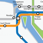
What Can We Take Credit For? The study quantifies benefits, but doesn’t claim that the result is entirely due to Metro alone.  For example, Arlington County highlights its economic success in the Rosslyn-Ballston corridor along the Orange Line, but transit is only one part of this success, along with zoning, development decisions, long-term policies, and other factors.  So, in this study we measure the benefits where transit is either a precondition for, or an integral part of, an impact.

Results: We’ll be publishing a few posts in this space shortly to explain the major findings of the study.  Stay tuned!  In the meantime, read the Final Report (pdf).

Cross-posted at Region Forward.

Gallery Pl-Chinatown Capacity Improvements Study Underway

September 22nd, 2011 13 comments

Ridership growth at the Gallery Place-Chinatown Metrorail station from 1977 – 2011.

The Gallery Pl-Chinatown Station is the third-busiest station in the Metrorail system, with an average of 26,000 daily passenger boardings in May 2011.  Combined with the Metro Center Station less than 1,000 feet away, these two stations facilitate downtown transfers on all five Metrorail lines, with the Yellow, Green and Red Lines at Gallery Place and the Orange, Blue and Red Lines at Metro Center. The Gallery Place Station consists of two side platforms that serve the Red Line on the upper level and one center platform that serves the Green and Yellow Lines on the lower level.

Redevelopment in the station area catalyzed by the opening of the Verizon Center in late 1997 has drastically increased the demand at this station, resulting in crowded conditions during the peak travel times throughout the station, including mezzanines, platforms and escalators.  Weekday ridership has increased from an average of 6,500 boardings in 1997 to an average of 26,000 in 2011. Although ridership has stabilized over the past few years, more growth is expected in the near future with new CityCenterDC development currently under construction at the old convention center site at 10th Street and H Street NW.

Metro’s planners are currently undertaking the Gallery Place Station Access and Capacity Improvement study, with the purpose of identifying capacity constraints and developing improvement alternatives at the station.  Similar to the Union Station Access Study, this study will provide simulations of the projected pedestrian environment on the platform at key milestone years, and will measure the effectiveness of the proposed capacity improvements.
Read more…

The Bicycle and Pedestrian Capital Improvement Program

August 18th, 2011 3 comments

Back in December, we told you about the Metrorail Bicycle and Pedestrian Access Improvements Study, which recommended ways for enhancing bicycle and pedestrian access in and around Metrorail stations.  Since then, Metro has been developing a capital program aimed at implementing some of these recommendations.  Here is an update on our progress and some discussion on what’s next:

Recent Highlights

In February, Metro’s Board of Directors adopted a goal to increase bike mode share from 0.7% to 2.1% by 2020 and 3.5% by 2030.  Around the same time, we made improvements to the bicycle section on Metro’s website.   This spring, we surveyed use and capacity of bike racks at Metrorail stations and conducted an inventory of unmet bike and pedestrian needs at Metrorail stations.
Read more…

What About a Faster Transit Route Between Dulles and the Core?

March 31st, 2011 39 comments

The planned Metrorail Line to Dulles Airport will provide a high-frequency, high-capacity link between the airport and the region’s core, and will enable travel between all Metrorail stations and the airport, without requiring rail-to-bus transfers.  Concerns have been expressed about the likely Metrorail travel times between the airport and the core, and the capacity of the Metrorail system, as trains converge through Rosslyn and pass under the Potomac River.  Could there be improvements that would provide faster service, expand the capacity, and also provide for greater flexibility for routing trains when service is disrupted, because of either incidents or planned major maintenance?

To attract riders, transit travel times need to “be competitive with” other travel options, yet setting that competitive bar at the level of auto travel times doesn’t seem to be necessary (nor is it readily achievable.)  Reagan National Airport attracts many transit trips, even though driving times to the airport are generally shorter than by rail.    While travel times need to be competitive, and a faster travel time would be more appealing and attract some more ridership, Metrorail to Dulles Airport will result in considerable transit usage by airport patrons and employees, not only to and from the core, but to Tysons Corner and other locations served by the Metrorail network.

Read more…

Categories: Strategies Tags: ,