Posts Tagged ‘studies’

Transit-Oriented Development around Metrorail Generates Local Tax Revenues

July 9th, 2013 1 comment

Proximity to transit, especially high-quality, frequent, high-capacity rail, increases property values, attracts development and provides mobility choices. Property values are higher near Metro’s high-quality, high-frequency, high-capacity services, and deliver an incremental increase in total tax revenue to the Compact jurisdictions.

  • Property taxes on land around Metrorail stations generate $3.1 billion annually in revenues to the jurisdictions.
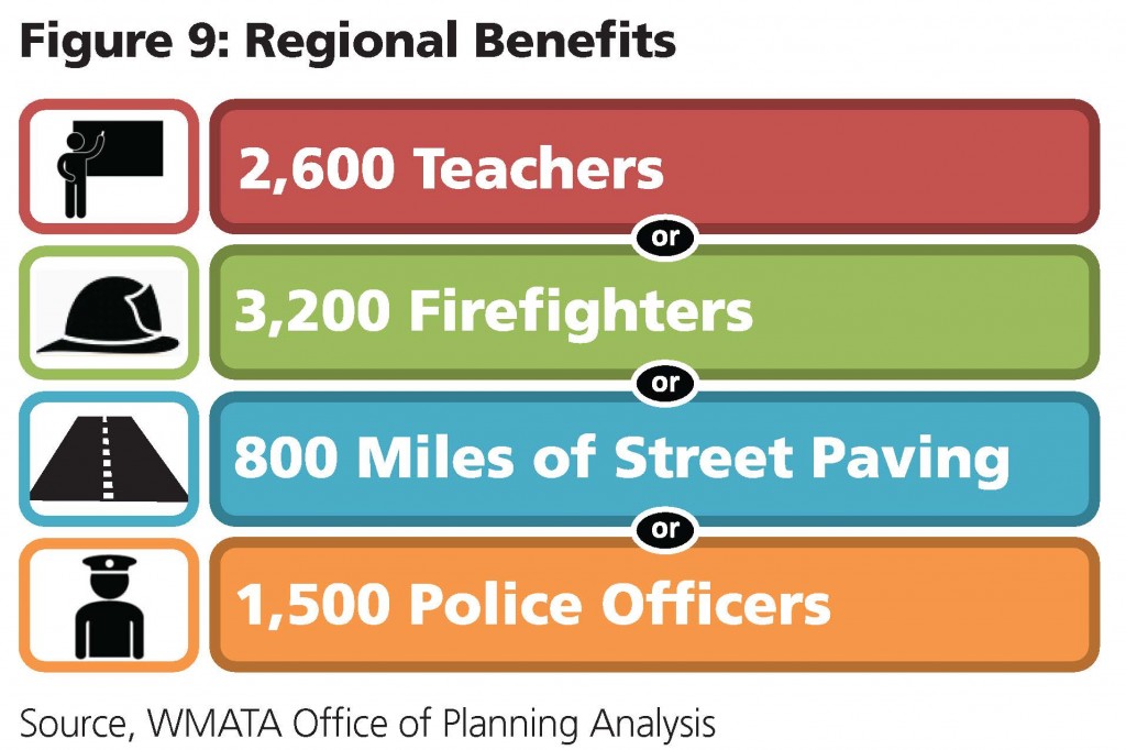
  • Of these revenues, $224 million is extra value that would not exist without Metro. This amount is equivalent to providing the following public services.

Regional Benefits - Police Firefighters

Read more…

Metrobus Route 80 Key Issues and Recommendations

July 2nd, 2013 7 comments

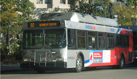
Photo-Metrobus-80-kennedy-centerMetrobus planning staff recently hosted the final public meeting on Metrobus Route 80, the “North Capitol Street Line.”  The purpose of this meeting was to share with the public a summary of the issues experienced by Route 80 riders and discuss possible recommendations for restructuring service, stops and route alignments to help alleviate crowding, reduce delay and increase service frequency.

The presentation boards are available for download.  (PDF, 15MB)  The key issues and a summary of preliminary recommendations are listed below. Read more…

Categories: Metrobus Studies Tags: ,

North Capitol Street Line (Metrobus 80) Final Public Meeting

May 16th, 2013 Comments off

80 Bus PictureThe final public meeting for the study of Metrobus Route 80 (The North Capitol Street Line) will take place next week!

You’re invited to come see and comment on the draft recommendations for improvements. The study team hopes to submit the final recommendations to the Metro Board this summer for approval.

The meeting is open to the public and will take place on:

Wednesday, May 22, 2013
Anytime between 5:30 pm and 7:00 pm
St. Anthony’s School
12th & Lawrence Streets NE
Cafeteria entrance at 3400 12th Street NE, ground floor

Read more…

Metro Studying Opportunities for Coordination of Regional LRT and Streetcar Systems

February 21st, 2013 1 comment

Streetcar and LRT Map

This map shows the corridors being studied by the region for potential light rail, streetcar, or bus rapid transit lines. Click the image for a larger version.

The Washington, DC metropolitan region may be the home of a light rail line and several streetcar lines in the near future according to regional plans.  The state of Maryland is in the preliminary engineering phase of the Purple Line, a 16-mile light rail line that is proposed to run between Bethesda in Montgomery County to New Carrollton in Prince George’s County.  The District of Columbia has almost completed construction of the H Street-Benning Road streetcar line, with scheduled revenue operation expected to begin later this year, and has also planned an expanded streetcar network.  Meanwhile, Arlington and Fairfax Counties have submitted an application for federal Small Starts funding to begin project development for the Columbia Pike Streetcar line, running almost five miles from Pentagon City in Arlington to Bailey’s Crossroads in Fairfax County.  Arlington County is also advancing planning for its Crystal City Streetcar project, which would run from Pentagon City, through Crystal City, to the southern Arlington County line in Potomac Yard.   (The Crystal City Streetcar project can be considered a follow-up to the Crystal City Transitway project currently under construction.)

Recognizing that Metro isn’t the sponsor or funding agent for these LRT and streetcar systems, and that key decisions made early in the process on the Columbia Pike and H Street streetcar lines have the potential to affect other systems for years to come, Metro has been coordinating with the sponsors since 2010 through the LRT and Streetcar Interoperability Study.  A briefing on this study was presented to the Metro Board in early 2011. Read more…

L’Enfant Plaza Station Capacity Improvements Study

December 6th, 2012 Comments off

The L’Enfant Plaza Station is one of busiest stations in the Metrorail system and handles thousands of passenger transfers on four of the five Metrorail lines.  It ranks third among all stations in absolute ridership growth over the last five years.

Earlier this year, Metro initiated a station capacity improvements study, similar to previous studies that evaluated the feasibility of station access and capacity improvements and station circulation enhancements at Gallery Pl-Chinatown and Union Stations.  The purpose of this study is to identify and address the physical and operational internal capacity constraints of L’Enfant Plaza Station.  Both short-term and long-term capacity enhancement solutions will be sought with operational improvements and constructability in mind.
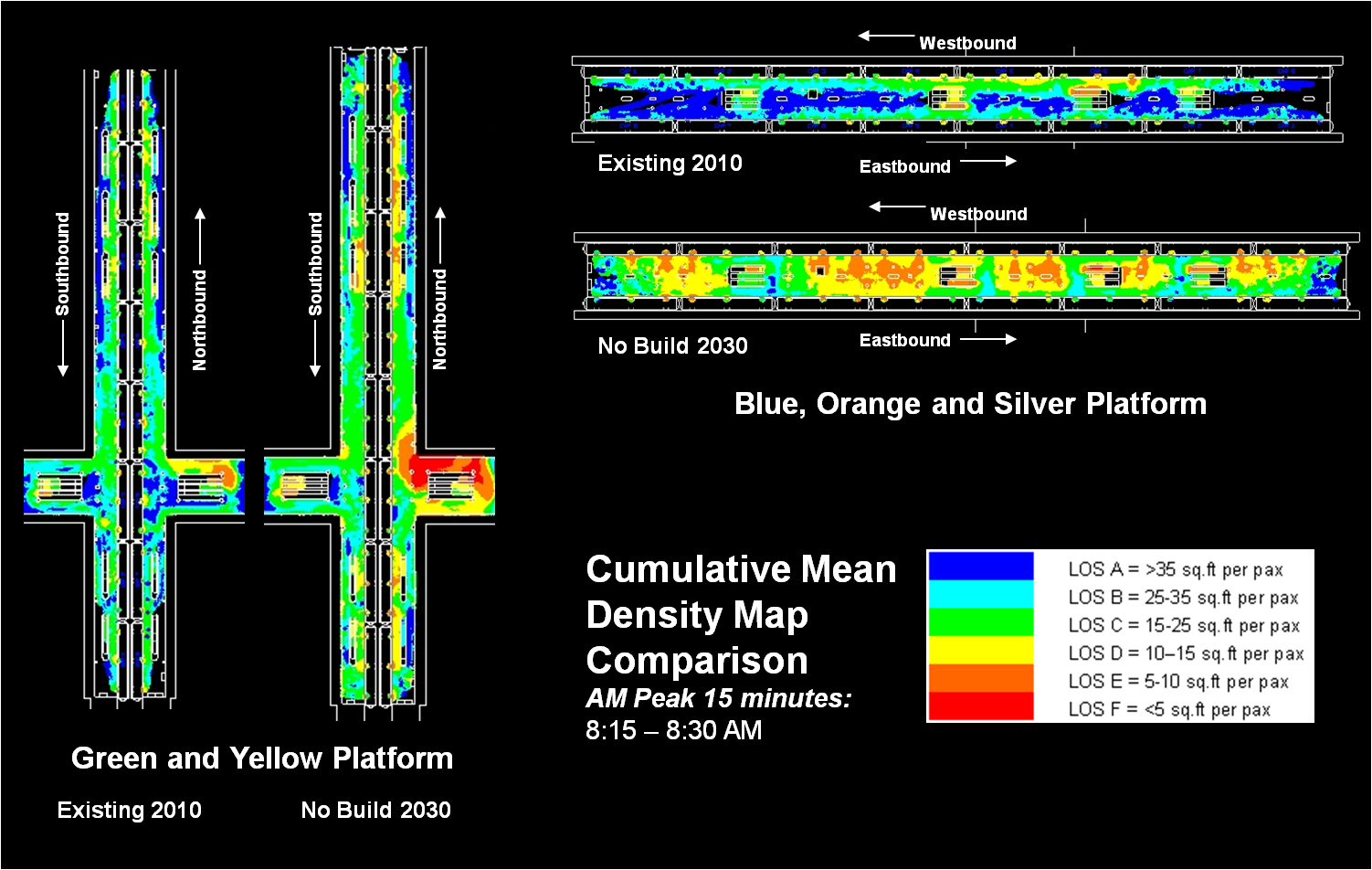
Current and Future “Hot-Spots” at L’Enfant Plaza Station Platforms during the AM Peak

In order to assess the current and future conditions within L’Enfant station, Metro has used a pedestrian simulation tool that enables the quantification of crowded conditions.  The maps included here show existing and future condition profiles of the upper and lower level platforms within the station.  Future conditions were estimated using MWCOG/TPB travel demand model, Metrorail ridership growth forecasts and Metro origin-destination data sources.  Cumulative mean density maps help to identify “hot-spots” within the station – areas where high levels of crowding are sustained.

Analysis of current pedestrian activity during the AM peak 15-minute interval showed that the station currently operates at safe levels on both platforms in the morning peak hour, and identified a large volume of transfers between the northbound upper platform where Green and Yellow lines run and the westbound lower platform where Orange and Blue lines operate.   By year 2030, however, these conditions are expected to worsen with growth of transfers.  The levels of crowding in the transfer areas leading to the lower platform intensify due to increased passenger flows and space restrictions adjacent to escalators.  Also, high passenger densities are shown to occur at the westbound Orange and Blue platform during the morning rush hours.

A reversed pattern of crowding is shown between the eastbound lower platform and the southbound upper platform for the returning passengers during the PM peak 15-minute interval.  As expected, conditions worsen with increased passenger flows and transfer activity forecast for 2030 on the southbound upper platform.
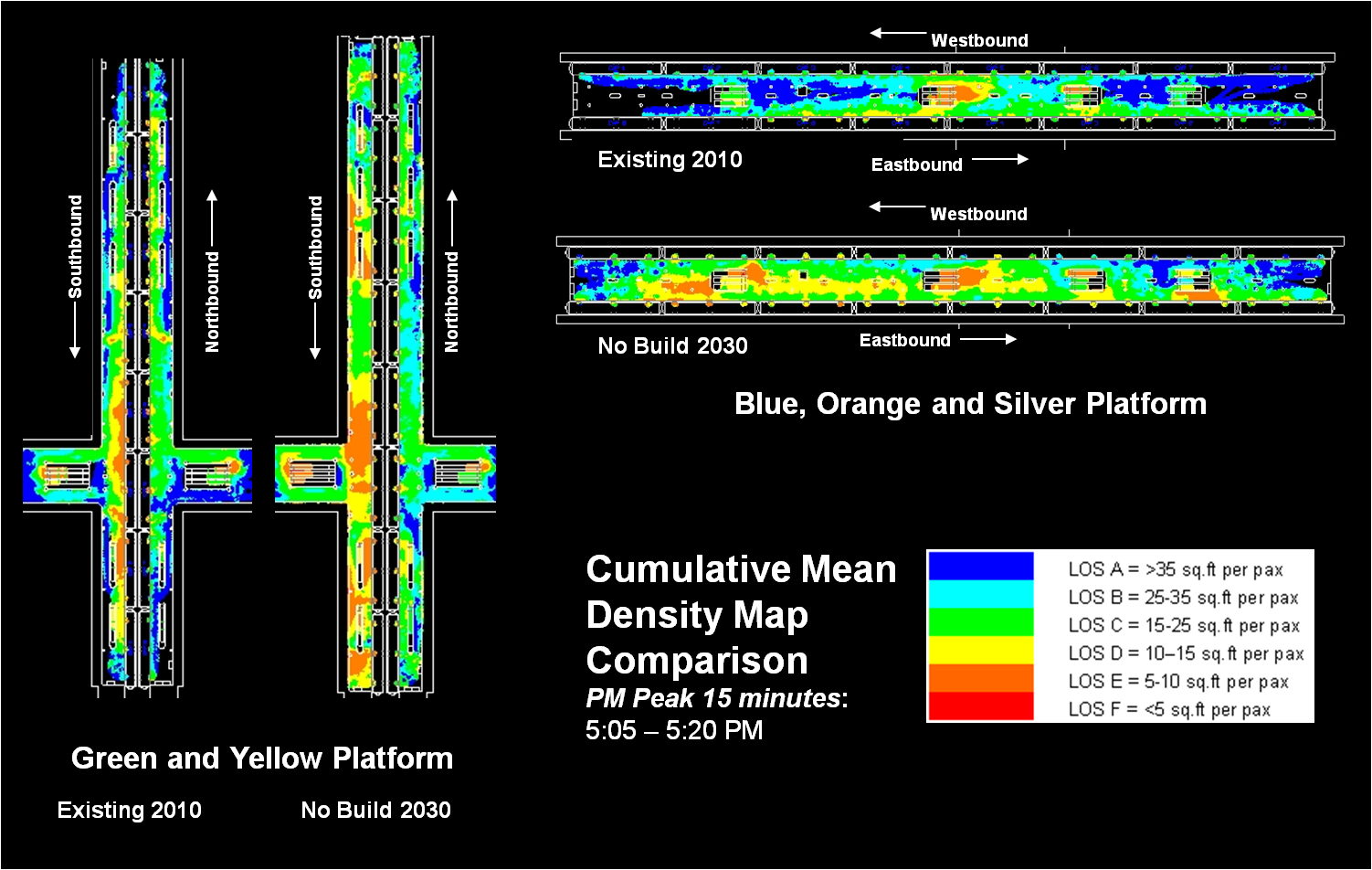
Current and Future “Hot-Spots” at L’Enfant Plaza Station Platforms during the PM Peak

Given the existing and future “no-build” scenarios presented here, Metro is currently working to develop short and long-term design alternatives for detailed evaluation.  Stay posted for additional simulation and conceptual design results as they become available.

MindMixer – What Happens to All Your Comments and Ideas

November 21st, 2012 Comments off

Since Metro’s MindMixer site opened on September 27th, the response has been overwhelming. To date, we’ve had over 425 participants provide more than 1900 votes, 450 comments, and115 ideason a range of topics. The first round of questions generated over 150 pages of comments alone! The site is expected to continue through the end of the year at a minimum, so please continue to join the conversation.

Metro is using MindMixer to start a conversation with our customers about how they envision the next generation of Metro. A quick review of the site shows a wide range of comments and ideas, some that are short-term and many that are very far in the future.

All comments and ideas are being reviewed as part of Momentum: The Next Generation of Metro, the agency’s strategic plan. Metro staff is responding to some of the comments and ideas as they are posted. Often this is to direct a participant to work that is already underway or to provide short responses or explanations of current policies. Other ideas have created discussions between participants, which is one of the main purposes for the site. The vast majority of ideas and comments require further study, more discussion of what is possible within Metro’s environment, and/or prioritization among other needs at Metro. Many of the ideas also require substantial resources to implement.

As the site continues, we are collating and summarizing your comments and ideas based on themes, such as core capacity, information provision, and non-Metro expansion.  This high level summary will be used to support Momentum, our strategic plan, as it provides an indication of the elements that are most important to you, our riders. We will also be taking comments directly from MindMixer to incorporate in the strategic plan document. As part of this blog, we will be further developing some of the ideas and comments to form the basis for a Metro 101 section on PlanItMetro. These posts will help increase the level of understanding of transit in this region. Lastly, for those ideas that require further study, they will be compiled and when MindMixer concludes, this information will be circulated to the respective Metro departments. This will help ensure that decision makers throughout the organization review the thoughtful ideas that have been provided on MindMixer.

Veirs Mill Road BRT Study Underway

November 21st, 2012 Comments off

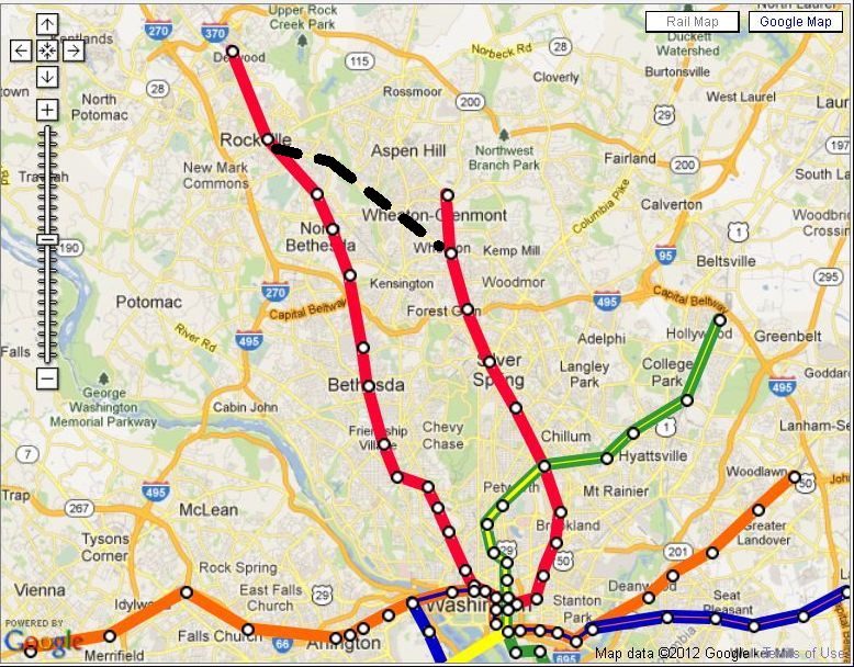
While Montgomery County’s Bus Rapid Transit (BRT) plan moves forward through the master plan update process, the county has prioritized some of these corridors for more detailed study.  One of these is the Veirs Mill Road corridor, generally stretching between the Rockville and Wheaton Metrorail Stations.  Managing the effort on behalf of the county is the Maryland Department of Transportation (MDOT) through the State Highway Administration (SHA) and the Maryland Transit Administration (MTA).  SHA, MTA, and Montgomery County hosted an open house in May to introduce the study to local residents and solicit feedback on some of the issues present along the corridor.  You can view the study’s webpage for more information, where you can access the May 2012 Open House material.

Strategic Importance

Why is the county advancing the study of this corridor?  One reason is apparent with a quick look at the area’s geography and relationship to major transportation corridors.

Veirs Mill Road (highlighted in black) in context

Read more…

Metro and the Region’s (Expanding) Transit Network

November 20th, 2012 1 comment

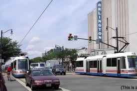
Conceptual rendering of the Columbia Pike Streetcar.

While many area residents think of Metro as the only regional transit provider, many transit projects under development in the region are being sponsored by Metro’s partner agencies. For example, the Silver Line is currently being managed by the Metropolitan Washington Airports Authority, and the Purple Line by the Maryland Transit Administration.

That doesn’t mean that Metro doesn’t have an important role to play in these projects. In fact, sometimes the project sponsors request that Metro – using its resources and expertise as the fourth-busiest transit system in the nation – manage aspects of the project development process.

For Arlington and Fairfax Counties, Metro managed the study of the Columbia Pike streetcar project. The study, which ended this past October, included an alternatives analysis/environmental assessment, conceptual plans and an application to enter the Small Starts program of the Federal Transit Administration.  Many of these documents are available online.  Arlington County continues the project’s development, soon to enter preliminary engineering.

For the District of Columbia, Metro has managed the feasibility study of the Benning Road streetcar extension. The study, which will end shortly, includes alignment alternatives and evaluation of bridge structures.

Metro is also coordinating the interoperability of the multiple streetcar lines.View the press release and the board presentation (PDF) about this study. Metro will be addressing Metrobus service and Metrobus fare transactions on streetcar lines.

Metro is proud to play a large and important role in the planning and coordination of transit projects around the region and is using its strategic planning process, Momentum, to explore ways that it can best serve the region’s transit coordination, operation, and development needs.

Categories: Planning Studies Tags: ,

TAG Meeting #9: RTSP Phase II: Review of Round 1 Scenario Results

November 2nd, 2012 4 comments

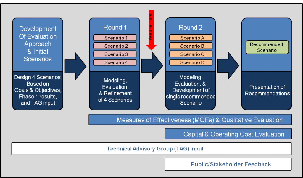
In September, we presented to the TAG the results of the first round of scenarios modeled in the second phase of the RTSP study.  Scenarios are defined by a collection of strategies or projects identified in the initial phase of the RTSP.  The four scenarios tested focused on maximizing the existing infrastructure, expanding surface transit, expanding transit in the core, and expanding transit system wide.  The performance of each scenario was evaluated against a set of measures to determine the relative effectiveness of each compared to the baseline scenario, defined by the regional list of projects in the currently adopted Constrained Long Range Plan, and MWCOG Cooperative Forecasts Round 8.0 land use.

Phase II Process Overview: Click to Enlarge

Regional measures such as total transit trips, mode share, vehicle miles traveled, households and jobs within a half-mile of transit, travel time savings, and transit congestion were evaluated to not only determine how well the scenarios performed against each other over the baseline, but to assess how well each satisfied the goals and objectives of the RTSP.  In addition to these broad-based regional measures, the first round of scenario modeling focused on how well each scenario addressed the need to expand capacity within the system core.  Peak period Metrorail link capacity and transfer activity at key core stations were measured against the baseline scenario to determine if the potential build scenarios could provide sufficient capacity to serve future demand, and how well such added capacity could be utilized.

For more information on scenario descriptions, measured results, and key findings download meeting materials: TAG 9 Presentation of Results

Read more…

Categories: TAG Tags: , , ,

Developing Metrorail Service Standards

September 5th, 2012 16 comments

Just as Metro has standards guiding major policy decisions for its bus services, we are now taking the first steps in establishing a similar framework for its rail service. Service standards are important to define service quality and quantity as well as future capital investment needs, such as increasing core capacity and adding more service. As with any standard, there are constraints. Physical constraints include equipment, system capacity and tunnel throughput. In addition to physical limitations, there are budget constraints for staff, to make system investments or to purchase more rail cars. To begin the formalization of service standards, Metro is starting with three, simple key standards:hours of service, rush hour headway and rush hour capacity. Establishing the foundation for rail service standards now will allow us to add more quality standards in the future. Additionally, these service standards will provide a base for further discussions to come in Board’s strategic planning effort. To ensure we’re heading in the right direction, we’d like your input. Watch this video and then please provide your comments.