Posts Tagged ‘access’

Chart of the Week: “Hotspots” for Pedestrian and Bike Access to Rail Stations
December 17th, 2012 11 comments

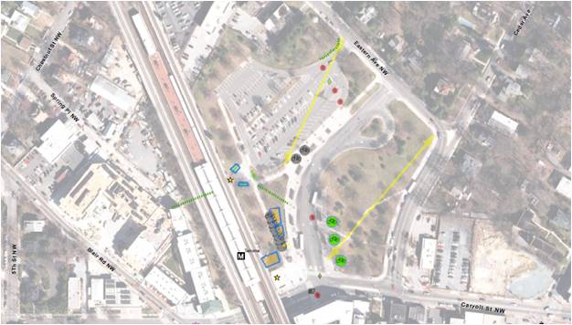
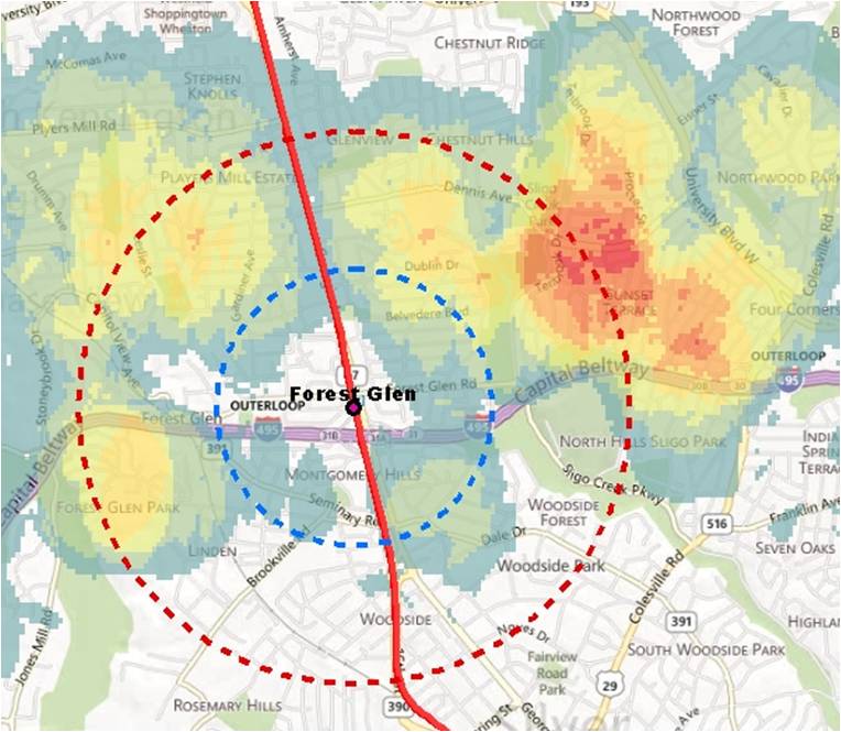
Heat map showing short-distance parking access at Forest Glen station, which indicates good opportunities for pedestrian and bicycle access (click for full map)

In our effort to improve safety, access and sustainability, Metro is expanding our understanding of bike and pedestrian barriers faced in commuting to our Metrorail stations. Over the past several years, we have focused our bike and pedestrian project planning and implementation efforts on improvements we can make to our station areas such as, installing bike racks or constructing pedestrian improvements. Now, we’d like to expand the envelope and develop a list of access needs beyond our own boundaries and work with our jurisdictional partners to make needed improvements.

One way we are doing this is by gaining a better understanding of where auto commuters come from when they drive to our stations, and zeroing in on areas where we see a good deal of auto access to determine if there are barriers to walking or biking to the station.

The map at right (full version) shows auto-to-station “hot spots” around the Forest Glen station, to pick one example, locations from which clusters of customers drive and park at Metro. According to the 2007 Metrorail Passenger Survey data, many customers drive from within a 1-3 mile radius; some are even closer. So why are so many people from this area driving? In our 2010 Bicycle and Pedestrian Master Plan, we teased out some of the more broad-based reasons why people drive rather than walk or bike – now we’d like to explore each station’s local conditions and see what can be done to improve walk and bike access.

The Forest Glen station is located north of the Capital Beltway and west of Georgia Avenue. More commuters to Forest Glen are from north of the Beltway and east of Georgia Avenue. There is pedestrian overpass over the Capital Beltway which helps facilitate foot traffic:  Is crossing Georgia Ave then a barrier?  There are four Metro rail stations located within a 2-mile radius of Forest Glen which draw away commuters farther from the station. This could help to explain the highly localized nature of the parking shed.

There are many factors not considered here such as demographics, bus usage, and average driving trends. Further research into parking and commuting trends is in the works.

If you commute from this area, can you comment about what you experience on your commute? Do you drive?  If so, what factors influence you to drive instead of walk or bike? Would you like to walk or bike, but the infrastructure isn’t there or the traffic is too daunting? Or do you see something else from this data? We want to hear from you and appreciate any feedback you have that can make our system more accessible to pedestrians and cyclists.

New Pedestrian Paths at College Park Station

June 6th, 2012 3 comments

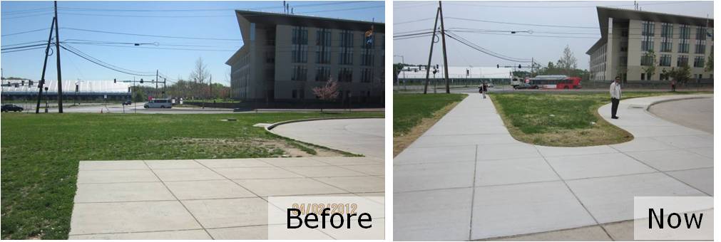
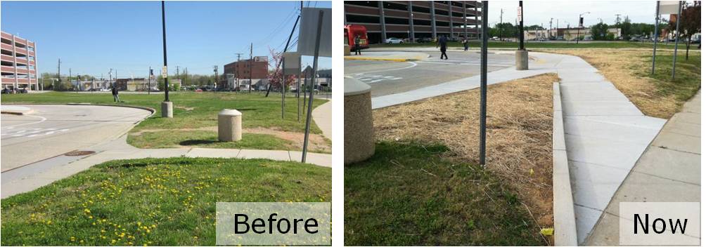
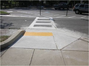
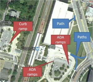
In conjunction with the Bike & Ride facility, Metro recently constructed multiple sidewalks on the east side of College Park – U of MD station to provide easier and safer pedestrian and bicycle access to the station and the Bike & Ride.  One of the sidewalks provides direct access to Paint Branch Parkway which leads to the Northeast Branch Trail less than ½ mile away.  In addition to the sidewalks, we installed curb ramps to meet ADA standards, and established a safer pedestrian route across the bus loop to the station entrance.

We undertook this work as part of Metro’s Pedestrian and Bicycle Element of 2012-2017 Capital Improvement Program.  We will be making bike, pedestrian, ADA and sidewalk improvements next at Cheverly, Landover, New Carrollton, Glenmont, Shady Grove, Brookland-CUA, Huntington, W. Falls Church, Vienna and Van Dorn.  What key bike and pedestrian connections at stations do you recommend be made?

Before and after pictures are shown below:

New pedestrian and bicycle improvements at College Park station.


Grand Opening: College Park Bike & Ride

May 14th, 2012 3 comments

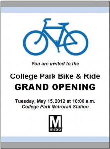
Metro will hold the grand opening event to launch its first “Bike & Ride” tomorrow – Tuesday, May 15 at 10:00am at the College Park-U of MD Metrorail station.  You are invited to join us that morning, where you can hear a few words from some elected officials and Metro leaders, take a few photos, and tour the facility.

Ready to get started? Sign up now for a $20 BikeLink card, read the brochure, and you’re on your way to secure bike parking.

Already tried out the facility? This first Bike & Ride is a pilot project to try a new kind of bike parking, so let us know what you think!  With the facility, Metro hopes to attract more bike commuters to rail by offering customers convenient, flexible, and secure bike parking.  Metro’s Parking Office will operate the facility, with help from BikeLink.  Metro hopes to learn from the design and continue to expand commuters’ access options as part of the Pedestrian and Bicycle Element of the Capital Investment Program. So, let BikeLink and us know what you think of the facility!

What Does the State of the Commute Survey Tell Us?

January 11th, 2012 1 comment

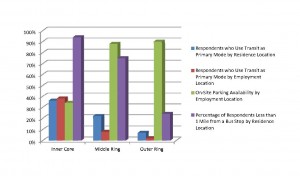
State of the Commute Survey Results

Last summer, the Metropolitan Washington Council of Governments (MWCOG) posted the results from the 2010 State of the Commute (SOC) Survey. Metro planners are reviewing the results now in support of our Regional Transit System Plan, which is looking to better connect areas of concentrated growth, such as the regional activity centers, and increase core capacity through 2040. The survey is conducted every three years to help MWCOG’s Transportation Planning Board better understand commuting trends and evaluate the effectiveness of its Commuter Connections program, which provides information about and benefits for commuting by transit and carpooling instead of single-occupancy vehicles (SOV).

Read more…

Identifying & Funding Pedestrian and Bicycle Project Needs

December 22nd, 2011 7 comments

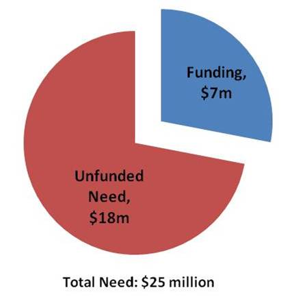
Back in August, we posted information about our latest endeavors to improve bike and walk access to Metrorail.  We have since completed our field work and now have a laundry list of more than 3,000 individual projects throughout the Metrorail system that we identified through that effort.  The projects range from the small and simple (e.g., Vienna racks) to the larger and more complex (e.g. additional Bike & Rides).  Metro’s Pedestrian and Bicycle Element of 2012-2017 Capital Improvement Program (1.1 MB, PDF) summarizes the findings by category, and provides an overview of the methodologies we employed to prioritize projects, as we identified a larger need than is currently funded.

And, although the  primary goal of this project is to provide a list of needed bike and pedestrian access projects to be funded through Metro’s Capital Improvement Program (CIP),  the list of needs developed in the inventory also will help better inform our partnerships on transit oriented development (TOD) and other projects near our stations.  Many of the projects improve the links from our station property to that of other property owners and will be instructive as stations undergo development transformations.

Project Highlights

Field teams were out evaluating conditions all over the system.  They highlighted desire lines to stations, bike parking needs, sidewalk & pathway improvements, intersection improvements and other pedestrian and bike needs.  Below are some high level summaries to give you a flavor of what we found out there:

Sidewalks and paths: Our field work identified hundreds of small sidewalk and pathway projects typically on Metro property that will improve access to our stations.  Each project tends to be small, say 200 to 500 feet long, but added together from end to end, they would stretch 10 miles.  Most of these projects are at suburban stations, where our entrances tend not to be directly located on the street network.

Intersection improvements: We looked at the intersections that serve our stations for places where new crosswalks, curb ramps, crossing islands or other improvements were needed and found 700 locations for such improvements.  Many of these are located off of our property on adjoining streets, so we plan to work with the local jurisdictions to address these.

Bike parking: More than 400 potential locations for future bike parking were identified, including the type and expected capacity of parking.  The field survey explored potential locations for additional Bike & Ride parking facilities and covers for bike racks.  Our plan is to build or reserve space for bike parking in the amounts needed to help us reach our mode share goals of 2.1% by 2020 and 3.5% by 2030.  To make these numbers work, we’ll continue to work with our local bike/ped planning partners to improve the on- and off-street connections to our stations so we can fill this bike parking.

Prioritizing Projects

So, 3000+ is a lot of projects.  We’d love to be able to do them all.  However, our funding is currently constrained.  So, what do we do? – we prioritize.  And, how do we do that?  We look to our Agency goals.  At the top of the list is safety & security, delivering quality service and using resources wisely.   We took a look at how our projects stacked up against these goals and created an action plan to complete the projects that best achieved them.  There are more details about the process in the attached document, but let it suffice to say we think we’ll make some real headway in meeting these goals and their accompanying objectives as we improve access to our stations.  In the meantime, if other funding opportunities crop up – say TIGER IV, or V, or XXXII – we’ll be ready to go.

Follow Along with Us

We have already begun work on the projects identified, and planning for more projects is underway.  As we complete projects we’ll continue to post them here.  Please let us know what you think.  Have they helped?  Are there other projects you see out there?

Update January 18, 2012: Maps of all project needs at by individual Metrorail station are available below. Due to the size of the files, we’ve posted them as 8 separate documents in alphabetical order by station name. They should be readable with Adobe Acrobat 6.0 or later:

  1. Addison Road-Seat Pleasant to Capitol South (PDF, 2.2 MB)
  2. Cheverly to Dunn Loring-Merrifield (PDF, 2.2 MB)
  3. Dupont Circle to Gallery Pl-Chinatown (PDF, 2.5 MB)
  4. Georgia Ave-Petworth to King Street (PDF, 6.0 MB)
  5. Landover to Metro Center (PDF, 1.2 MB)
  6. Minnesota Ave to New York Ave-Florida Ave-Gallaudet U (PDF, 7.0 MB)
  7. Pentagon City to Twinbrook (PDF, 3.2 MB)
  8. U St/African-Amer Civil War Memorial/Cardozo to Woodley Park-Zoo/Adams Morgan (PDF, 2.4 MB)


Balancing Transit Mode of Access with Urban Design in Suburban Settings: A Comparative Assessment of Four European Transit Systems

May 27th, 2011 1 comment

Metro’s early experience with promoting TOD took place at below-ground rail stations in established urban settings that did not require the provision of transit access facilities beyond connections from sidewalks to the stations below. More recently, WMATA’s opportunities to develop its land to support TOD have been predominantly in suburban rail stations that include extensive parking lots, bus bays, and facilities for taxis, bicycles, customer pick-up and drop-off, and ADA patrons.

The default agency policy in recent years has been to replace existing facilities with a like amount and kind of facilities on a reduced footprint, and to emphasize transit operational functionality over urban design issues.  For example, this approach has tended to favor placing parking structures and bus bays adjacent to the station in lieu of pedestrian facilities, public spaces and mixed-use development.  However, public feedback has prompted WMATA to reassess the appropriateness of this default approach, and there is a need for new thinking about how future patrons should arrive at suburban stations; how transit operations should function in TOD contexts; and how to better meet local development policy objectives.

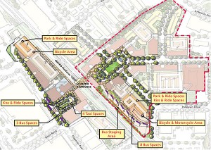
Development plan for Twinbrook Metrorail station.

Development plan for Twinbrook Metrorail station. Click the image for more information.

Over the past five years, WMATA has made a number of significant policy and program changes to recognize the changing development environment at suburban rail stations. For example, in 2008 WMATA adopted a new set of real estate development guidelines (1.91 MB PDF), and the first real estate projects implementing those guidelines were initiated in the summer and fall of 2010. While the evolution of WMATA’s planning and land development practice is underway, it is far from complete. WMATA’s most recently-launched TOD projects confront the agency with the immediate challenge of replacing first-generation, auto-oriented transit access facilities with a new generation of facilities that supports transit access, transit operations, and TOD.

Read more…