Posts Tagged ‘access’

Solving the Region’s Congestion Woes – One Step at a Time

March 17th, 2014 1 comment

One solution to the region’s crippling congestion could be right under our feet – literally.

This post is part one of a three-part series.

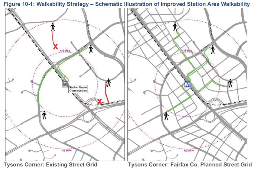
Illustration of possible walkability improvements that could occur in/around Tysons Corner. From Regional Transit System Plan


The region is abuzz with $220B of planned new transportation investments – the Purple Line, HOT Lanes, new streetcar lines, and additional roadways. Though there is not one dollar currently pledged to add capacity to Metro, these other investments may help the region chart a course away from leading the country in congestion (pdf).

However, for a quarter trillion dollars, one would expect that collectively these projects would have significant impacts on the region’s congestion. While there are some benefits – vehicle miles traveled (VMT) per capita are expected to decline and  transit mode share may increase by one percent – overall increases in VMT are expected to outpace road construction, leading to a 38% increase in the number of lane miles of congestion (pdf). But is there another way to get more bang for our buck?

Make station areas walkable. Every one of them. Now.

Read more…

moveDC Public Workshop Announcement – Comment on DC’s long-range transporation plan!

October 18th, 2013 Comments off

moveDCThe District Department of Transportation (DDOT) is hosting its third and final round of public workshops in October to discuss moveDC, DDOT’s initiative to develop a strategic, multimodal long range transportation plan for the District.  The public is encouraged to attend a workshop to review the draft plan and help prioritize the transportation options. The October workshops will enable you to:

  • Share your ideas and observations on future plans for transportation;
  • Learn how three approaches to a future DC transportation system perform;
  • Review the results of our survey research;
  • Provide input into the draft transportation plan; and
  • Learn more about the moveDC local bus study.

Online Survey

Throughout October, you are also invited to participate in a survey to comment on and critique three approaches that have the potential to transform the way people travel in the District.

Public Meeting Dates and Locations

Monday, October 21

7:00 a.m. to 6:00 p.m.

Union Station

625 First St NE

Tuesday, October 22

6:30 p.m. – 8:30 p.m., with a formal presentation 7 p.m.

Dorothy I. Height/Benning Neighborhood Library

3935 Benning Road, NE

Saturday, October 26

1:00 p.m. – 4:00 p.m.

DCUSA Retail Center, 2nd Floor, between Target and Best Buy

3100 14th St. NW

Wednesday, October 30

6:30 p.m. – 8:30 p.m., with a formal presentation 7 p.m.

Petworth Neighborhood Library

4200 Kansas Ave., NW

Web Meetings

Visit www.wemoveDC.org for more details and to sign up.

October 24, noon – 1:00 p.m.

October 28, 7:00 p.m. – 8:00 p.m.


How Do Metrorail Riders Get to Their Station in the Morning?

September 30th, 2013 3 comments

Peds_CrystalCityTwo-thirds of Metrorail riders take transit, walk, or bike to Metrorail for their morning commute.

Every morning, thousands of people walk through the faregates and into Metrorail. Did you ever wonder how they get to their station? Our 2012 Metrorail Passenger Survey tells us the answer to this question, for the morning rush:

  • More than a third (38%) of Metrorail riders get to the station in the morning by walking or biking.
  • Another quarter arrive by bus – Metrobus, as well as other bus operators in the region.
  • Another third arrive by car – most by parking at or near the station, but some by getting dropped off.
  • Finally, about 4% of riders arrive via commuter rail – mostly at Union Station.

Of the 25,000 or so daily riders who access rail by “Other Bus,” the top three contributors are Fairfax Connector (6,700), Montgomery County’s RideOn (5,700), and private shuttles (4,900). Of those who parked at their station, one-third were driving from less three miles away. Carpooling to Metrorail is very low – we estimate average vehicle occupancy at 1.03 passengers per parked car.

Systemwide_Metrorail_AccessMode_May2012

The map below shows how the answer to “How Did They Get to the Station?” varies dramatically station to station. (For the sake of legibility on this map, I’ve simplified the access modes into 4 groups). Read more…

Bicycle Access to Metrorail On the Rise

August 26th, 2013 2 comments

The number of Metrorail customers riding their bike to the train station increased by 50% over the last 5 years, as Metro makes progress towards its 2020 goal to attract more bicyclists.

More cyclists are accessing Metrorail by bike than ever before.  According to results from the 2012 Metrorail Passenger Survey, the number of riders bicycling to Metrorail in the morning rush hour increased from around 1,550 to over 2,380 per day between 2007 and 2012. Bike access to Metrorail now accounts for 1% of entries each morning, which moves us closer to our Board-adopted goal of over 2% (over 7,000 bicycles!) by 2020.

Bike Access to Rail 2012

In this survey, riders who access rail by bicycle in the morning peak could be taking Capital Bikeshare to the station, riding and parking their own bike at the station, or bringing a folding bike on-board.  The Passenger Survey is one way we measure bicycle access. We see a similar pattern in our annual count of bike racks at stations each spring (currently nearing completion for 2013, stay tuned).

The growth in bike access has happened at the same time as bicycling is increasing generally in the region, and as Metro has added more bike racks at stations to accommodate and encourage bicycling, including a secure Bike & Ride parking prototype facility at College Park station.

Categories: In The News Tags: , , ,

Time for Those Walking Shoes, Part 2

August 1st, 2013 5 comments

Walk access to Metrorail has increased 15% over the last 5 years, especially from those living within a half-mile of the station.  

So more rail riders are choosing to walk to their Metrorail station, according to the 2012 Metrorail Passenger Survey. But who are these pedestrians?

Around 40% of Metrorail customers in the AM peak walk to the station.  The survey found that younger people are much more likely to walk, with those under 35 were nearly twice as likely to walk to the train as those over 35:

Walk_Access_to_Metrorail_2012_by_OverUnder35However, younger Metrorail riders are also more likely to live within walking distance of their Metrorail station. Half of all riders under 35 live within a half-mile Metrorail, while 22% of those over 35 do.  Younger people in our region generally are slightly more likely to live near Metrorail –  15% of everyone under 35 in the region lives within a half-mile of Metrorail, 12% for those over 35. The chart below shows how younger riders tend to live closer to Metrorail: Read more…

Time for Those Walking Shoes, Part 1

July 30th, 2013 7 comments

Walk access to Metrorail has increased 15% over the last 5 years, especially from those living within a half-mile of the station.  

More and more Metrorail riders are lacing up their walking shoes and taking a short walk to their rail station these days.  According to results from the 2012 Metrorail Passenger Survey,  the number of passengers walking to Metrorail each morning grew by 15% between 2007 and 2012, from 78,500 to 89,900 in the AM peak period – far outpacing overall growth in ridership in the same period.

Where are all the new pedestrians coming from?  From stations all over the network, but the growth is strongest among those walking a half-mile or less.  Those walking from less than a half-mile rose by over 20% – faster than the overall growth in walk access.

Walk access to Metrorail has increased 15% over the last 5 years, especially from pedestrians walking a half-mile or less.

Walk access to Metrorail has increased 15% over the last 5 years, especially from those living within a half-mile of the station.

Read more…

Categories: Engage Tags: , , , ,

Huntington Station Auto Access “Hotspots”

July 25th, 2013 2 comments

Heat map showing parking access within 1 mile and 3 miles at Huntington station, which may indicate good opportunities for pedestrian and bicycle improvements  (click for full map)

Heat map showing parking access within 1 mile and 3 miles at Huntington station, which may indicate good opportunities for pedestrian and bicycle improvements (click for full map)

We continue to explore barriers to pedestrian and bicycle access to Metrorail stations with a look at Huntington station. Previous posts in this series explored Forest Glen and Southern Avenue stations.  All stations profiled share similar characteristics in that they have a high percentage of short-distance (less than three miles) parking access, and low bicycle use.  By looking at street layout, customer distribution and gathering your comments we are working to better understand barriers facing pedestrians and bicyclists and improve safety.

The map on the right (full version) shows auto access “hotspots” for Huntington station. Huntington is located in Alexandria Virginia less than a mile south of interstate 495, the Capital Beltway.

The station serves as a park and ride option for commuters from south of the DC metropolitan area as it is the last station on the southern end of the Yellow Line and is easily accessible from the interstate. Still, roughly half of the 3,600 daily parking customers originate from the many residential areas within three miles of the station.

Short distance parking customers almost exclusively originate from south and west of the station. The Potomac River, Capital Beltway, and proximity to Eisenhower Ave, Kings Street, and Braddock Road stations also along the Yellow Line seem to influence this. Read more…

Goal 3 – Improve Regional Mobility and Connect Communities

July 18th, 2013 Comments off

Metro will be the region’s transit planner, providing leadership for the transit map of the future. 

The region’s public transit needs are great, Regional Weeday Ridershipand the current multi-party approach has flaws that threaten the overall viability of the network. Metro is the only entity that is capable of and chartered to provide regional transit leadership.

Metro has and will continue to make these and other investments, but it should be noted that jurisdictional partners will also have to do their part in order to ensure that these investments result in significant improvements. This means cooperating on mobility policies, coordinating on capital investments such as traffic signal prioritization, and making land use decisions that support transit usage and ridership gains, especially in areas where Metro has underutilized existing capacity.

Read more…

MetroAccess – Serving the Region’s Disabled Community

July 1st, 2013 Comments off

Metro is the nation’s most MetroAccess Average Annual Ridershipaccessible large transit system. All 86 Metrorail stations have elevators and the new 7000-series rail cars are designed to maximize accessibility. Metrobus operates 1,100 fully accessible buses, most of which are low-floor and ramp-equipped and all of which have automated stop announcements. Numerous other changes have been made by Metro to maximize usability so that many customers with disabilities are able to use Metrobus and Metrorail for some of their travel. However, inadequacies such as the lack of curb cuts, sidewalks and traffic signals impact disabled customers’ ability to use Metrorail and Metrobus. MetroAccess serves these trips and others and presently provides about two million trips per year.

Read more…

Southern Ave Station Auto Access “Hotspots”

May 13th, 2013 8 comments

Heat map showing short-distance parking access at Forest Glen station, which will be incorporated into the next rail to bike planning effort (click for full map)

Heat map showing parking access within 1 mile and 3 miles at Southern Ave. station, which may indicate good opportunities for pedestrian and bicycle improvements  (click for full map)

Last December we looked at the Forest Glen station and asked you for insights on why people coming from so close (less than three miles) would drive to the station. In the upcoming weeks we are taking a look at five additional stations that also have a high percent of short-distance parking access and low bicycle use: Southern Ave, Glenmont, Largo Town Center, and Grosvenor-Strathmore. For each, we will explore the station’s local conditions and we ask you to share your insights about what can be done to improve walking and biking access to these stations.

The map on the right (full version) shows auto access “hotspots” around Southern Ave station. The Southern Ave station is located just southeast of the boundary between the District of Columbia and Prince George’s County.

Many residential neighborhoods are located within the three-mile radius of the station, and a large concentration of parking users residing within one mile of the station.

However, many possible barriers could inhibit non-motorized travel to Metro:

  • Southern Ave SE is a fast-moving, four-lane road that is uninviting to pedestrians, despite traffic signals, sidewalks and streetlights.
    • WalkScore.com gives the Southern Ave Metrorail station a walk score of 52 out of a possible 100.
  • The station has no direct connectivity to the surrounding residential neighborhoods.  All access to the station must occur via Southern Ave SE.  As such, many neighbors of the station must travel long and circuitous routes to access Metrorail.  See the image below.
  • The station nestled into a corner of Oxon Run Park, further limiting station access routes for nearby residents.

Read more…