‘Strategic Planning’

What Metro 2025 Means for the District of Columbia

March 13th, 2014 Comments off

Metro 2025 would bring significant benefits to the District of Columbia, allowing the city to thrive economically while preserving neighborhoods and downtown vitality.

Metro’s Momentum plan calls for seven Metro 2025 initiatives – from eight-car trains to bus-only lanes, which will bring dramatic improvements to the quality of life and transportation in the District.


Benefits Icons_Expansion

Supports D.C. Transit Projects

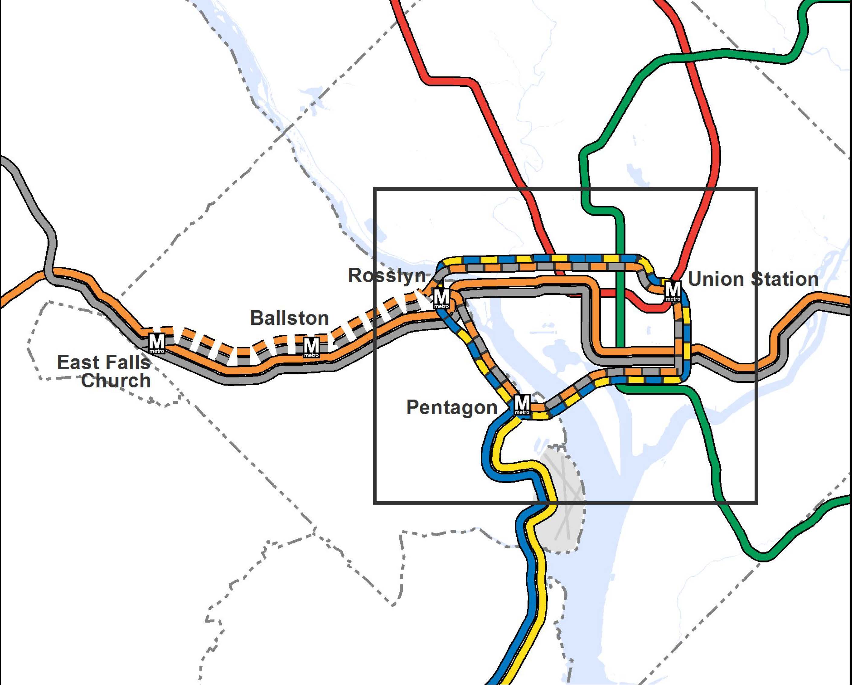
The District has committed to a 50% market share for public transportation, and is building a Streetcar and expanded Circulator network that will depend on robust Metrorail and Metrobus services. Metro concurs that the Streetcar and Circulator are worthwhile ventures, but they will always rely on the supporting regional “backbone” of Metrorail and Metrobus in order to deliver their intended results.  Consider that every single planned D.C. Streetcar line in the 22-mile system begins, ends, or connects with a Metrorail station, and the importance of sufficient capacity on Metrorail becomes quite clear.

Today, more than 100,000 people a month transfer between Metro and the Circulator.  By 2040, even the first few lines of the D.C. Streetcar (those funded in the CLRP, not even counting the full 22-mile system) are projected to generate thousands of additional transfers to Metrorail and Metrobus each day.

DC-CLRP-Projects

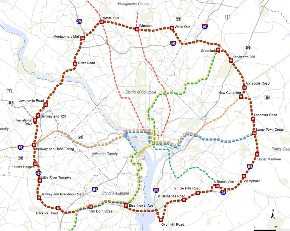
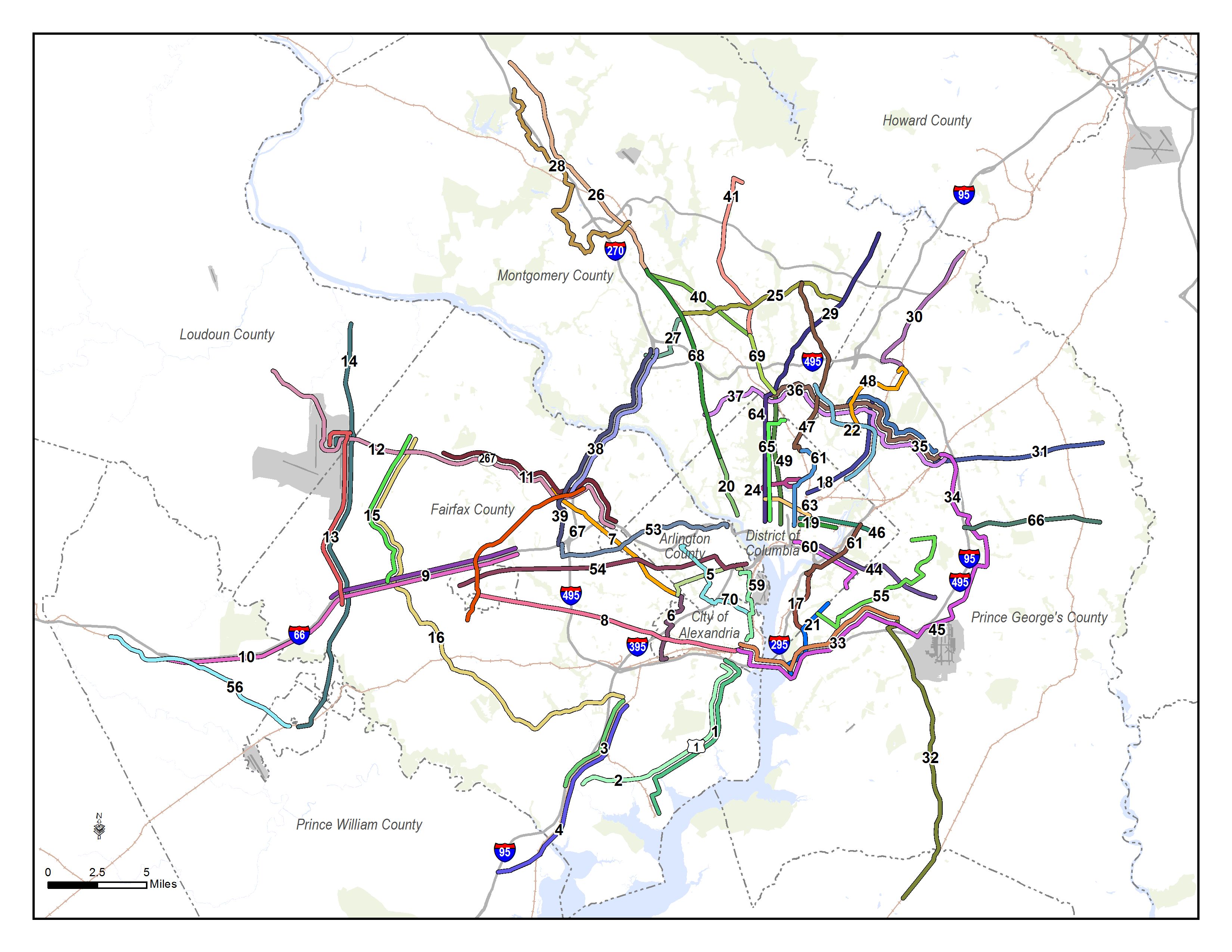
D.C. Streetcar projects funded in the CLRP. The planned 22-mile system would construct even more lines.

By ensuring that Metro services can keep pace with congestion and demand, Metro 2025 is critical to making D.C.’s transit projects a success, and critical to helping D.C. reach it’s transportation goals.


Benefits Icons_Support Growth

Supports D.C.’s Growing Population and Economy

The District of Columbia’s population is surging, and its economic and population growth is only projected to grow. With that growth comes significant transportation needs, and Metro 2025 is critical to Metro’s success in meeting that growth.

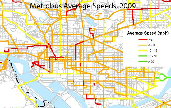
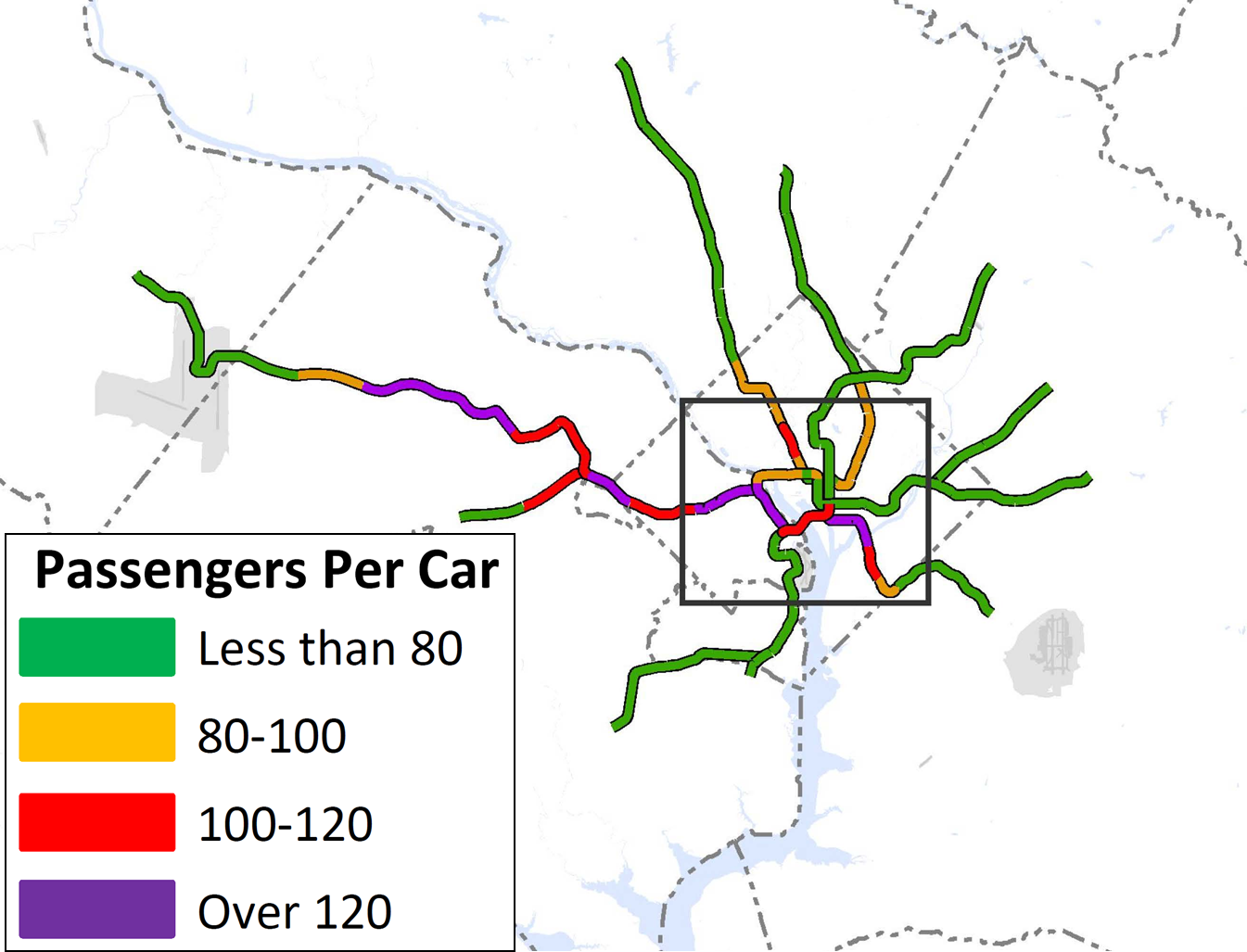
To handle this growth, D.C. needs the rail and bus system that Metro 2025 would deliver: 8-car trains capable of moving the equivalent of 16-18 lanes of highways into the District, superior bus service, and more. For example, Metrobus is helping the 16th Street NW corridor to grow – ridership has surged by over 5,000 trips per day, and today buses are 3% of the vehicles but move 50% of the people on that road. Read more…

Metro 2025: Why Now?

March 11th, 2014 1 comment

Four reasons why we need to begin the Metro 2025 investments now.

1. Because Metro 2025 is critical for growth. For the last three decades, the Washington region has grown in lockstep with an expanding transit system.  Since Metrorail opened in the late 1970s, the system has grown steadily, and in 2014 Metro provides two to three times more service (rail and bus vehicle-miles) than it once did.

For decades, this region has grown in lockstep with Metro.

Today, no significant new Metro service is planned beyond the Silver Line, yet MWCOG estimates that the region will continue to grow at a steady clip for years to come.  The only transit expansion projects that are planned complement and depend on connections to Metro, such as the Corridor Cities Transitway or Columbia Pike Streetcar, and may even increase the strain on Metrorail’s core.

2. Because we could lose jobs.  Without investment in the region’s transit backbone, economic growth and prosperity is threatened. In fact, studies have shown a clear link between growing congestion and declines in job growth. Without Metro 2025, this region could stand to lose nearly 133,000 jobs by 2040.

3. Because Metrorail is crowded, and it will get worse without Metro 2025. Today, Metrorail is reaching its capacity in many places. On the Blue and Orange lines for instance, Metro is running trains every 2.5 minutes, which is the most the infrastructure can handle, but even so, many trains are too full to board, or experience uncomfortable levels of crowding. Lines form at many stations to get through escalators, elevators, and fare gates.

Without eight-car trains and fixing station bottlenecks, crowding and congestion on Metrorail will continue. The map below shows our projections of crowding (passengers per car) into the future, if we don’t undertake Metro 2025:

Crowding on Metrorail will worsen without the investments in Metro2025.

Crowding on Metrorail will worsen without the investments in Metro 2025. (Animated.)


4. Because Metrobus is stuck in traffic and needs relief. Metro’s buses are frequently caught in street traffic, which increases travel times, degrades reliability, and increases Metro’s operating costs just to maintain frequencies.

Bus-Speeds

Illustration of Metrobus speeds from 2009. The red is 5 MPH or less. Click for full version.

In fact, numerous Metrobus corridors operate at speeds of less than 10 MPH, and several showed speeds of under 5 MPH.  On many corridors, buses operate at a brisk walking pace even though they are carrying many more passengers than the traffic around them.  On H and I Streets NW, buses carry 40% of the passengers but are only 2% of the vehicles. On 16th Street NW, buses carry 50% of the passengers, despite using just 3% of the vehicles.

To increase bus service, speeds, and reliability, we need to invest in bus-only lanes, bus priority at traffic signals, and additional buses.


What Are the “Metro 2025” Projects in Momentum?

March 6th, 2014 1 comment

Metro’s Momentum plan calls for seven medium-term capital initiatives – known collectively as Metro 2025.  And last week, Metro applauded a funding agreement from Maryland, Virginia, and the District of Columbia for $75 million as a “down payment”  to begin work on Metro 2025.  This is welcome news, indeed, and allows Metro to prepare to begin work on much-needed capacity increases to support the region’s growth.

Those of you who are less familiar with Momentum may be wondering: “What exactly are these projects?”

In a nutshell, the Metro 2025 initiatives are:

M25 Icons_All 8s

Eight-Car Trains

Today, most Metrorail trains have only six cars, and that means crowding  – which is only projected to worsen.  This project would enable Metro to run all eight-car trains in the peak period, which are the longest possible in our stations, and add 35% additional capacity to the rail network. It would expand the rail fleet and yards, and improve the power and signal infrastructure to handle the load.

M25 Icons_PCN-01

Core Station Improvements

If we lengthen the trains, we need to expand key stations as well! Since-eight car trains add capacity for 35,000 more trips per hour, 80% of rail customers transfer or alight in the core, and most of these core stations are already over capacity, we need more core station capacity. This project would enlarge platforms, and add escalators, elevators, stairs, and pedestrian passageways to 15 stations.

M25 Icons_Bus Fleet

Bus Priority Corridors and Fleet Expansion

The Priority Corridor Network would construct bus-only lanes, give buses priority at traffic lights, and bring service similar to MetroExtra to 24 lines throughout the region. The PCN will take tens of thousands of cars off the road, add 100,000 riders, moving buses 50% faster, and cut fuel costs.

In addition, this project would expand Metro’s bus fleet by around 400 buses, allowing us to increase frequencies.

M25 Icons_New Blue Line Options

New Blue Line Connections

Metro faces a bottleneck at Rosslyn station, where three lines (Orange, Silver, Blue) converge. This major project would try to fix this bottleneck, and restore six-minute Blue Line frequencies between Pentagon and Rosslyn stations. We are analyzing the feasibility of a few options, including a second Rosslyn Station that would enable underground transfers between the two stations.

M25 Icons_NexGen Communications

Next Generation Communications

This program would expand our current communications infrastructure to provide an integrated one-stop communication hub for the regions’ transit customers. Improvements would include: radio system upgrades, real-time bus information at bus stops, and new public address system at stations.

M25 Icons_Pocket Tracks

Pocket Tracks and Crossovers

This project would add special trackwork at key locations in the rail network to give us more flexibility with Metro’s two-track system. These new tracks would allow us to turn trains around, add system flexibility to Metro’s two-track system, and store trains at important locations.

Categories: Metro 2025 Tags: , ,

Why isn’t Metro looking at a line to [insert address here]?

December 20th, 2013 10 comments

[Editor’s note: this will be our last post of 2013.  We look forward to seeing you again in early January.]

You name it and we tested it as part of our analysis and development of the Regional Transit System Plan (RTSP). Here’s the comprehensive list of what was analyzed.

List of Transit Corridors, Projects, and Plans Analyzed as Part of RTSP

List of Transit Corridors, Projects, and Plans Analyzed as Part of RTSP

We have received tons of great comments on the proposed 2040 network of Metrorail and high capacity surface transit corridors. Many of you have said that we missed <insert corridor here> or have asked why we don’t have a line to <insert address here>. As part of this plan, we have analyzed almost every corridor or mode that you have identified. However, we recognize that most of it was behind the scenes and is buried deep in our posted presentations to the Technical Advisory Group (TAG).

Above is a list of what was analyzed before we unveiled the proposed 2040 Metrorail Network and regionally significant high capacity corridors. Better yet, here is a document that shows the Metrorail lines and other surface transit plans, projects, and strategies that were tested over the course of the project. Everything is listed and where possible, maps and graphics are provided to illustrate what was tested. All tested items were measured against a comprehensive set of measures of effectiveness (MOE). The MOEs assessed ridership, impact on core capacity, transfers, reduction in vehicle miles traveled (VMT), mode share, etc.

To wet your whistle, below, check out the Beltway Line that was tested. Only the segments that crossed the American Legion Bridge (between White Flint and Dunn Loring) and the Woodrow Wilson Bridge (between Branch Avenue and Eisenhower Avenue) had some promise and therefore, they continued on in the analysis, though as surface transit not Metrorail. The other segments did not provide good ridership, primarily due to the low densities within a walkable distance from the Beltway, and had little impact on Metrorail core capacity.

Alignment of a Beltway Line that was tested in the RTSP

Alignment of a Beltway Line that was tested in the RTSP

Let us know what you think!

More than Metrorail: The Region’s Most Important High-Capacity Surface Transit Corridors

December 19th, 2013 14 comments

In parallel with the proposed 2040 Metrorail network, we have identified 25 regionally significant corridors that merit high-capacity surface transit by 2040. Depending on the corridor, high-capacity surface transit can be provided more efficiently and effectively by modes other than Metrorail.

The best transit systems in the world are comprised of large networks served by multiple modes. In the National Capital Region, due to the growth and dispersal of activity centers, the high demand placed on Metrorail, and the realities of transit funding, expanding the transit network needs to occur by expanding transit on the region’s roads and highways not just by Metrorail. Metrorail is not and cannot be the best mode for every corridor because the vast majority of corridors do not have the land use, density and ridership to support it.

But don’t despair! There are plenty of other high-capacity modes such as bus rapid transit (BRT), light rail (LRT), streetcar, and enhanced bus that can provide:

  • high-frequency;
  • all day service;
  • large, comfortable vehicles; and
  • lower capital and operating costs than Metrorail.

Regionally Significant High Capacity Surface Transit Corridors as part of 2040 Regional Transit System Plan

Regionally Significant High-Capacity Surface Transit Corridors as part of 2040 Regional Transit System Plan

Read more…

Proposed 2040 Metrorail Network

December 5th, 2013 91 comments

Step right up and check out the proposed 2040 core Metrorail configuration with new Blue and Yellow Lines and a third line in Virginia!

Proposed 2040 Metrorail Core Configuration

Proposed 2040 Metrorail Core Configuration

Proposed 2040 Metrorail Network

Proposed 2040 Metrorail Network

What does this network do? The proposed rail network shown above is expected to reduce future crowding on Metrorail, provide enough capacity for future development, and expand the reach of transit in the region, especially to regional activity centers.

Why are we proposing it? This rail network is part of the 2040 Regional Transit System Plan (RTSP). Its purpose is to develop the rail and surface transit network for 2040 that meets the needs of the growing Washington DC region.

What else have we considered? About a month ago, we posted about some of the possible long-range changes to the Metrorail core that we are considering as part of the RTSP. We analyzed four different core configurations, gathered your comments, and the final configuration for the core is shown above. As many of you commented, it is a combination of two of the scenarios (Scenarios B and C).

Next Steps: The next and final step for the RTSP is to use this configuration, along with the high capacity surface corridors, to conduct a final round of analysis. The output will provide us with information on ridership, mode share, levels of crowding, transfers, etc. and ultimately a final network for 2040.

Let us know what you think!

A few extra notes:

(1) The Metrorail network shown in this post will be layered with an extensive high capacity surface transit network to expand transit and meet the needs of employment and population growth in the region.

(2) For the plan to have validity and acceptability across the region and within the federal planning process, it is based on the region’s adopted cooperative land use forecast for 2040. We used the Aspirations Land Use scenario to stress test the core of the system, but ultimately the plan needs to start with the region’s adopted land use. As follow on work to this plan, we will be testing different land uses to see what else we can learn to improve long-range plans.

(3) All of the lines shown, as well as all of the high capacity surface transit corridors, will need corridor studies, alternatives analyses, and full engineering studies. This cannot be done at a regional level, but would need to happen on a project by project, line by line level. So, while we are showing a new Blue Line on M Street, it very well could be on N or P Streets.

Q&A with Mary Hynes: WMATA and Arlington County Board Member

October 21st, 2013 Comments off

Picture1

Mary Hynes, a Metro Board Member, sat down with the Region Forward team to answer a few questions about the region’s biggest challenges, how Metro can help the region meet the goals in Region Forward, and how citizens can get involved. In addition to her role at Metro, Ms. Hynes is an Arlington County Board Member and the Chair of the Council of Governments’ Region Forward Coalition, the public-private group leading the effort to implement COG’s vision for the region’s future.

Q: What do you think are the regions biggest challenges?

Mary Hynes: “The economy is a big challenge. We are still figuring out ‘the new normal’ with the federal government. The issues of housing and how people move efficiently around the region are also critical. It’s critical that we understand how housing and multimodal transportation options fit into the bigger picture of achieving a thriving region built of individual vibrant communities – one that is also attuned and committed to meeting the social equity requirements of our diverse, sustainable region.”

Q: How does Metro help us meet our Region Forward goals?

Mary Hynes: “The Metro Board made a decision when considering how to frame its new strategic plan to key off of Region Forward. We – my colleagues on the Metro Board and Metro’s professional staff – looked at what regional leaders had done with Region Forward—the goals they had set—and said “Metro can be the catalyst that enhances regional mobility and convenes stakeholders to ensure a successful, integrated regional multi-modal system”. We worked with the Transportation Planning Board at COG to make sure Momentum and the TPB’s Priorities Plan are aligned.  It wasn’t hard because, in fact, there is regional consensus on the next set of transportation moves the region needs to make.

It’s an exciting time to be participating with COG and Metro. It’s a remarkable moment because people share the same vision. Leaders across the region have learned the same lessons. So the time is right!  Just as regional leaders did 50 years ago when planning Metro, we all must lock our arms, commit to a funding plan, and move forward together.”

Read the full interview!

Momentum and ConnectGreaterWashington: What’s the Difference?

October 7th, 2013 Comments off

Momentum is just one component of Metro’s vision for the future of transit in the Washington region.

We know that there are many questions about the relationship between Momentum, Metro’s strategic plan, and ConnectGreaterWashington, Metro’s long-range Regional Transit System Plan. These are two really ambitious, visionary plans that put forth a vision both for the Authority itself, as well as the transit map of the future. So below is a handy reference guide that compares the two plans across a variety of factors. This FAQ is a work in progress, so please add questions below and we will modify the table with other key details.

Momentum

ConnectGreater
Washington


Momentum 


Logo_WMATA_RTSP_001 black 

Purpose
  • Develop actions that Metro can take to meet the mission, vision and goals adopted by WMATA’s Board.
  • Identify key infrastructure initiatives, defined as Metro 2025, that Metro can implement to maximize the existing system without expanding it.
  • Develop the future transit map that the region needs to meet its projected population and employment growth.
  • Note the plan is being developed without specific operators in mind, especially for the high capacity surface transit corridors. However, a subset of the overall plan will come under Metro’s purview, build on Metro 2025, and ultimately become Metro 2040.

Read more…

RTSP Evaluating and Prioritizing Corridors for High Capacity Transit: Dispatch from TAG Meeting #10

October 4th, 2013 1 comment

This is the second post in a two-part series based Logo_WMATA_RTSP_001 blackon content from the tenth meeting with the Regional Transit System Plan (RTSP) Technical Advisory Group (TAG) that was held in July. The first post focused on our analysis of new Metrorail lines in the core and Virginia. This post is about our approach to identify regionally significant corridors for high capacity transit. 

By 2040, multiple regionally significant travel corridors will need high capacity, high frequency transit to connect people and jobs outside of the core.

As part of the RTSP, we will identify regionally significant corridors where transit priority infrastructure is needed to provide high capacity transit. At the TAG meeting, Metro Planning staff presented a methodology to identify, evaluate, and prioritize these regionally significant corridors. The methodology has evolved since the July meeting and is described below. The actual evaluation and prioritization is still in process.

WMATA RTSP II Corridors Segments 082813

Corridors identified for evaluation for high capacity transit.


Since the TAG meeting, we have also conducted one-on-one meetings with each jurisdiction and agency in the RTSP study area to review and gather feedback on the full set of corridors that will be evaluated. Approximately 70 corridors have been identified from:

Read more…

RTSP Analyzing New Metrorail Lines in the Core and Virginia: Dispatch from TAG Meeting #10

October 3rd, 2013 39 comments

This is the first post in a two-part series based Logo_WMATA_RTSP_001 blackon content from the tenth meeting with the Regional Transit System Plan (RTSP) Technical Advisory Group (TAG) that was held in July. This post will focus on our analysis of Metrorail capacity and crowding, while the second post will focus on identifying and prioritizing regionally significant surface transit corridors.

By 2040, ridership and crowding levels on Metrorail indicate the need for a new Blue Line and new Yellow line in the system’s core and a third line in Virginia.

At the time of our last post, we had run an initial round of four scenarios that sought to resolve regional mobility issues. We gathered a lot of information from the results, but realized that we needed to run a second round of scenarios focused almost entirely on Metrorail. Using MWCOG’s Cooperative Forecast Round 8.1 land use, which has been adopted by the region, and MWCOG’s Aspirations land use, which shifts more jobs and households into the regional activity centers, the maps below clearly demonstrate crowded conditions in 2040. The Base Network shown in these maps includes 100 percent eight-car trains and all the CLRP projects. Crowded conditions exist on the Orange Line west of Rosslyn, on the Yellow and Green Lines south of L’Enfant Plaza, and on the Silver Line west of Tysons. Because the results indicated that Metro would be severely crowded EVEN if we run the longest possible trains (eight-car trains), we wanted to explore other long-term solutions.

WMATA-RTSP-II-Baseline-No-Aspirations-Land-Use-Loads-071513-wLEGEND

Crowding on Metrorail by 2040, even with the longest possible (eight-car) trains. Base Network AM Peak, Round 8.1 Cooperative Forecast

WMATA-RTSP-II-Baseline-Aspirations-Land-Use-Loads-071513-wLEGEND

Crowding on Metrorail in 2040 even with the longest possible (eight-car) trains, Base Network AM Peak, Aspirations Land Use

Read more…