
More than Metrorail: The Region’s Most Important High-Capacity Surface Transit Corridors
In parallel with the proposed 2040 Metrorail network, we have identified 25 regionally significant corridors that merit high-capacity surface transit by 2040. Depending on the corridor, high-capacity surface transit can be provided more efficiently and effectively by modes other than Metrorail.
The best transit systems in the world are comprised of large networks served by multiple modes. In the National Capital Region, due to the growth and dispersal of activity centers, the high demand placed on Metrorail, and the realities of transit funding, expanding the transit network needs to occur by expanding transit on the region’s roads and highways not just by Metrorail. Metrorail is not and cannot be the best mode for every corridor because the vast majority of corridors do not have the land use, density and ridership to support it.
But don’t despair! There are plenty of other high-capacity modes such as bus rapid transit (BRT), light rail (LRT), streetcar, and enhanced bus that can provide:
- high-frequency;
- all day service;
- large, comfortable vehicles; and
- lower capital and operating costs than Metrorail.

Regionally Significant High-Capacity Surface Transit Corridors as part of 2040 Regional Transit System Plan
As part of the 2040 Regional Transit System Plan (RTSP), over 70 corridors were evaluated and prioritized. Most of these corridors are not new and probably are not surprising - they were identified in partnership with local jurisdictions and state agencies and many of them are part of ongoing planning studies. Some corridors may have a mode identified, such as those included in Montgomery County’s BRT Plan, while others such as Fairfax County’s Proposed High Quality Transit Network have not.
25 were identified as regionally significant and these are shown on the map above. By regionally significant, we mean that these are:
- key corridors from a regional perspective;
- show high transit ridership;
- provide transit-supportive household and/or employment densities; and
- connect multiple regional activity centers.
These corridors would have transit service implemented with transit priority, such that transit can bypass traffic congestion and provide fast, reliable service. Because this project is focused on moving people and meeting future demand, we have not identified specific modes for each corridor - this would come with more detailed corridor-level alternatives analysis. Instead, we identified origins and destinations between which high-capacity transit is needed in the future and prioritized the most important regional corridors as part of the network. All the remaining corridors will still have local transit, but those on the map are the corridors where funding and priority should be placed. These high-capacity transit corridors, along with the projects in the financially constrained long-range plan, 2040 proposed Metrorail network and local bus system will create a robust, comprehensive, multi-modal transit network that meets the needs of the growing region.
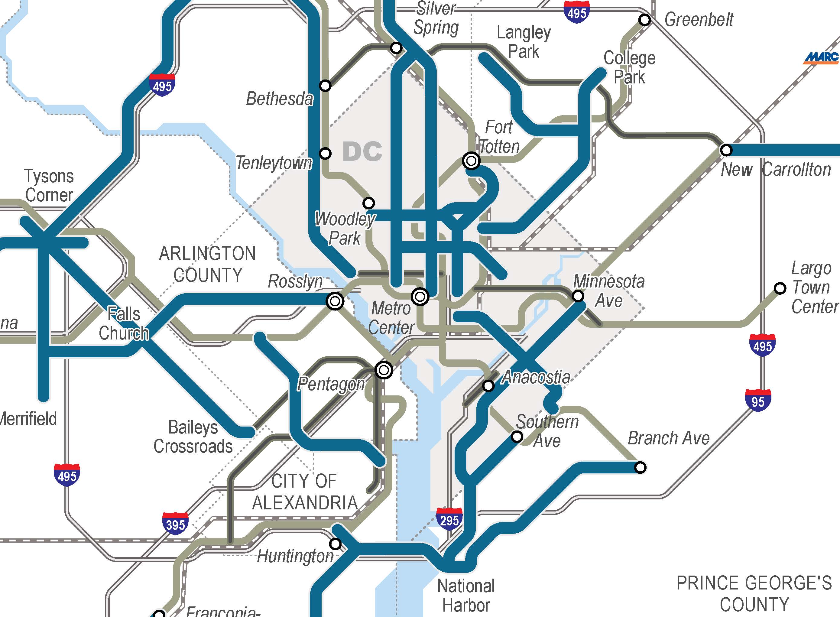
Regionally Significant High Capacity Surface Transit Corridors Inside the Beltway
Let us know what you think!

So apparently the US 29 corridor (Colesville Road/Columbia Pike) doesn’t merit consideration? But Glebe Road, and three separate lightly used routes into National Harbor do?
@Joe in SS
Joe - it was considered, but did not meet the thresholds for employment and household density, ridership, and connection to regional activity centers. The purpose of these regional corridors is to try to identify the key corridors for regional investment. We have limited funds and cannot spend them on every single corridor - otherwise we spread resources across too many corridors and get little in return. If densities increase on that corridor (or any of the others), we can certainly reassess. However, what is planned in the region’s adopted cooperative land use for 2040 for that corridor did not meet the thresholds.
For your reference, here’s the map of everything that was considered: https://planitmetro.com/2013/10/04/rtsp-evaluating-and-prioritizing-corridors-for-high-capacity-transit-dispatch-from-tag-meeting-10/
@Allison While I appreciate that explanation and all of the hard work that went into this plan, it really doesn’t seem fair that Montgomery and Prince George’s counties appear to have many fewer corridors in this document than DC or Virginia. Metrobus ridership in Maryland is nearly twice as high as in Virginia. There are five bus lines in Maryland that have more riders than the highest-ridership line in Virginia. Shouldn’t existing ridership should justify more investments in transit?
I understand that transit and land use are closely tied, but Montgomery County especially has been very serious about encouraging higher-density land use throughout the county, not just on 355 and Georgia Avenue. We’re planning the new White Oak Science Gateway around the Food and Drug Administration at the junction of Route 29 and New Hampshire Avenue, already two well-used Metrobus corridors, but neither of them are considered “regionally significant”?
If we’re going to have a transit system that provides a serious alternative to driving, and tackles the regional jobs-housing imbalance, only investing in new transit on the west side of the region won’t solve the problem. I hope Metro is willing to reconsider these corridors and properly ensure that all parts of the DC area have access to high-quality surface transit.
@dan reed!
Thanks Dan. I totally understand where you are coming from. A couple of other things to point out - this is not a Metrobus/rail only plan. This takes into account ALL transit operators in the region - local bus (RideOn, ART, TheBus, Fairfax County Connector, etc.) so while the numbers on Metrobus are higher in MD, the overall picture may not be the same when totaling all of the operators.
We know that it is an important corridor for Montgomery County and are not saying that shouldn’t remain that way. What we are trying to do with this plan is identify what are the key corridors across the entire region. Every corridor that every county identifies as important cannot be regionally significant for the region as a whole. For your reference, in Montgomery County, in addition to the CCT and Veirs Mill Busway that are included in our 2040 base network, below are the MontCo BRT corridors that our analysis identified as regionally significant based on the 2040 Cooperative Land Use:
• MD 187/Old Georgetown Rd
• 355 South Corridor
• GA Ave South
• MD 355 (North to Clarksburg)
I have to agree with Joe and Dan above, not having the US 29 corridor in MD is short sighted and tells me that only existing land uses were studied in this analysis, and little thought was given to plans a jurisdiction has to revitalize an area. The County Council for Montgomery County has a draft of the White Oak science gateway plan headed to their desks to add the zoning to allow tens of thousands of new jobs and thousands of new residential units. A plan that requires BRT to connect the area to Silver Spring and beyond to built. This is not just a dead end corridor to White Oak either. This corridor connects to the ICC, near the eastern terminus that connects in to Laurel and the planned Knoterra Town Center, and this corridor becomes the main highway of Howard County. So often people in the DC area ignore Howard County, when much of the growth of the past 10 years there is attributed to the expanding Washington DC influence - that’s not all Baltimore economy going on up there. With plans to transform downtown Columbia, I think sending a transit arm via bus to Columbia may be worth the regions while if we can route them all the way out to central Loudoun and Prince William Counties! This in conjunction with this new ‘loop’ of Blue and Yellow lines in the core of downtown DC, one can’t help but think some serious favoritism is being played to Virginia by WMATA, which is ironic because at the State level, that government is still not the most progressive or transit friendly.
Joe, Dan, and Gull are right. By what possible standard does Bowie-New Carrollton rank as more important than US-29? Existing ridership is lower, land-use patterns are less dense, and plans for future development are not nearly as far along.
The exclusion of the Upper Georgia Avenue corridor, between Glenmont and Olney, is also a glaring omission. It’s one of Maryland’s highest-ridership routes, with a lot more development potential than, say, the Potomac Yards-Ballston route.
In the near future, there are several plans to implement and study bus service improvements in Montgomery County. Effective December 29th, WMATA will implement an extension of the MetroExtra Route K9 limited stop service on New Hampshire Avenue from the Northwest Park Apartments up to White Oak at the Food and Drug Administration Campus. Early next year, a Priority Corridor study of the Metrobus Z routes in the Colesville Road-Route 29 corridor will be initiated.
Remember, WMATA will not be making the final determinations on these routes, even less than on the metrorail changes. This will depend on the jurisdictions and what they are willing to fund. Fairfax has expressed strong commitment to adding frequent transit on key arterials (this map does not include Braddock road west of the beltway, where FFX is looking at adding a deicated bus lane). If MoCo, Howard, and Md want a line up rte 29 that will be quite possible, and the mapping of lines on Glebe road in Arlington, or other parts of NoVa, will not be an obstacle.
I’m quite shocked that the Southern Maryland Light Rail plan has been left off this map. I understand people’s concern over Route 29 not getting shown as a major corridor, that should have been included, though MDOT doesn’t have strong plans to add additional high capacity transit in this corridor yet.
Southern Maryland light rail has been on the books fora while now and is marked as a significant corridor in other places, in fact it’s the next rail transit system in line to receive funding after the Purple Line and Baltimore red lines are finished. Points south from Branch Avenue to Charles County are clamoring for a transit line of some sort and are starting to secure right of way for this Route 5 corridor.
For Reference:
“Light rail gets boost with transit study”
http://www.somdnews.com/article/20130710/NEWS/130719766/1103/jefferson-patterson-park-group-sews-costumes-for-war-of-1812-re/Light-rail-gets-boost-with-transit-study&template=southernMaryland
“Southern Maryland Commuter Rail Service Feasibility Study”
http://www.mdot.maryland.gov/Office_of_Planning_and_Capital_Programming/Southern_Maryland/Documents/Southern_Maryland_Commuter_Service_Technical_Memorandum_07282009.pdf
“Light Rail Remains Top Transportation Goal”
http://www.thebaynet.com/news/index.cfm/fa/viewstory/story_ID/26543
“Infrastructure Investment: Charles County’s Light Rail Strategy”
http://www.charlescountymd.gov/sites/default/files/ed/Gary%20Hodge%20CCED%20Summit.pdf
1) It seems strange that the blue line only runs as far as Lorton when it should at least be going to Dumfries.
2) The Leesburg pike Corridor should be connected with the Van Dorn Corridor instead of stopping at Bailey’s Crossroads. It’s only another mile about and it connects Bailey’s and especially Pentagon to the behemoth BRAC building at Mark Center.
3) What about 236? Perhaps BRT Connecting Fairfax City to Old Town.
4) Also Prince William and FFX County will probably consider a BRT or a priority Bus service from Woodbridge/Dumfries to Mannassas to Centreville to finally Herndon/Reston.
A major error is the statement that other modes have lower operating costs than MetroRail. NOT SO. The National Transit Data Base for largerf cities in 2011 reote that Rapid Rail (MetroRail) cost onl40 cents per passenger-mile to move its riders, but Rrgional Rail like MARC and VRE cost 45 cenys per and Light rail cost 70 cdnys per. Urban buses were over a dollar per passenger-mile, more than double Rapid Rail. (This assumes modes are put in heir proper climate). Also, thde csa be no econkc justifucatio for Bjs Rp\apid Transit. In Pittsburgh wwith three excliusive BusWays, bjs riding is down 47 %. Our Shirel Hihwa Busway lost 67 % of its Route 17 and 18 riders between 1982 and 1996. Blue Metro Rail attracted 500 % more. Ottawa is replacing BRT with Light Rail to cure bad problems. Overthe pas 30 years, records show urban bises gained on,h 3 % in ridin but Rapid Rail gained 65 ^, Regional Rail 70 % and Light Rail 400 %. Los Sngels has had ver similar experience except tha wit no Light rail until 1990, there can be no incessdcalcuatde from a zero base.
@Ed. L. Tennyson, P.E.
Ed Tennyson’s comments should be heard loud and clear. the typos can be blamed on him being in his 90’s but he built one of the first busways in Pittsburg as a management person on thier transit system, and formerly asst director of Penn dept of transportation. his spelling isn’t that great, but his numbers are rarely wrong, he is still sharp as a tack.
ignoring Ed is at your own peril
Bob
not related but have worked with him and known him for over 25yrs
@Andrew
Andrew, the Southern Maryland Transit Corridor from Branch Avenue to Waldorf was studied. See corridor #32 on this map: https://planitmetro.com/2013/10/04/rtsp-evaluating-and-prioritizing-corridors-for-high-capacity-transit-dispatch-from-tag-meeting-10/. However, it just doesn’t have comparable the density and ridership, nor does it connect that many regional activity centers. It may be on the books, just like all the other corridors that we analyzed are on the books somewhere, but with this region’s limited funds, the question is really what is the subset of all of those corridors that need to be prioritized.