‘In The News’

Metro Planning Director to be Featured on Dr. Gridlock Chat Monday

July 26th, 2013 5 comments

The Director of Metro’s Office of Planning, Shyam Kannan, will be the guest on The Washington Post Live‘s Dr. Gridlock lunchtime chat this coming Monday, July 29, at noon.

You can submit questions online now or during the chat itself.

Shyam will be answering your questions about planning for the future of Metro, including Metro’s strategic plan, Momentum.

Categories: In The News Tags:

Board Member Mary Hynes Discusses Momentum on Comcast Newsmakers

July 11th, 2013 Comments off

Mary Hynes — Board Member with Arlington County and WMATA Board of Directors Member — was recently featured by Comcast Newsmakers, discussing sustainability efforts as well as Metro’s strategic plan, Momentum.

Ms. Hynes describes Metro’s “Big Ideas” for 2025, including: the need for “all 8-car trains” during rush hour; additional crossovers and pocket tracks to provide more flexibility during peak period operations, emergencies and trackwork; and priority for Metrobus on city streets and highways.

Check out the video below and let us know your thoughts in the comments.


Categories: In The News, Momentum Tags: , ,

Metrobus Service Improvement Changes Take Effect on June 30

June 27th, 2013 Comments off

New Metrobus schedules and service improvements take effect Sunday, June 30.  More trips and schedule adjustments will reduce crowding and improve reliability.

Pick up a copy of the Metrobus Service Changes brochuregrab a new timetable on-board your bus, or look it up online!

DISTRICT OF COLUMBIA

More trips on the following lines:

  • Route 32 Pennsylvania Avenue  – weekday mornings
  • Route 63 Takoma – Petworth – weekday mornings and afternoons
  • Route K2 Takoma – Fort Totten – school days
  • Route W4 Deanwood – Alabama Avenue – weekday evenings and weekends

Schedule adjustments:

  • Routes 42,43 Mount Pleasant – every day
  • Route 63 Takoma – Petworth – weekdays
  • Route 94 Stanton Road – weekdays
  • Routes 96, 97 East Capitol Street – Cardozo – every day
  • Route D5 MacArthur Blvd. – Georgetown – weekdays
  • Routes U5,U6 Mayfair – Marshall Heights – every day
  • Route W4 Deanwood – Alabama Avenue – weekends

MARYLAND

Schedule adjustments :

  • Routes C2,C4 Greenbelt – Twinbrook – weekends
  • Route P12 Eastover – Addison Road – weekends
  • Routes B21, B22 Bowie State University and Route C28 Pointer Ridge
  • Route 89M Laurel and Routes G12, G14 Greenbelt – New Carrollton
  • K6 New Hampshire Avenue and K9 New Hampshire Avenue Limited during the weekday PM peak period

The following lines will have earlier weekday service:

  • Route F13 Cheverly – Washington Business Park
  • Route R1 Riggs Road

The following line will have later service:

  • Route C27 Central Avenue from Six Flags Park.

 VIRGINIA

  • Service to Landmark Mall will be discontinued and new service to Braddock Road and Hampton Drive will be added on Routes 7A,E,F,Y Lincolnia – North Fairlington.
  • Service on Route 8W will be modified and service on 8X will be eliminated and replaced with additional 8W trips on Routes 8S,W,X,Z Foxchase – Seminary Valley.
  • Later weekday evening service to Culmore on MetroExtra Route 16X Columbia Pike – Federal Triangle.
  • MetroExtra designated stops will be added at Columbia Pike and Oakland Street to serve Routes 16X and 16Y.

For more information or assistance, call Metro Customer Information at 202-637-7000 [TTY 202-638-3780] or look for your new timetable online

Categories: In The News Tags: ,

Blast from the Past: Metro Here and Now

June 5th, 2013 10 comments

We were made aware of this video entitled, “Metro: Here and Now.” Take a look:

The video contains footage on the initial operating segment of the Metrorail Red Line from Rhode Island Avenue-Brentwood to Farragut North, with a strip map including Dupont Circle as well as several shots of Metro CenterSo we can surmise that Given some of the points made in the comments, the video probably dates from 1976 sometime in the period from 1975 – 1977, around the time that first rail segment opened in 1976. Aside from the interesting clothing and hairstyles of the time, one of the things that stands out is the operation of 2-car trains. This is difficult to imagine today, when 6-car and 8-car trains are the norm during all operating periods, and plans are being developed as a part of Metro’s Momentum Plan to operate 100% 8-car trains during peak periods.

Another interesting feature of the video is the landscape surrounding some of the stations. While the properties near Judiciary Square, with the DC courthouses, the National Building Museum, and Metro’s Jackson Graham Building appear mostly unchanged today, other station areas look different. At 8:44 in the video, you can see a train pulling into the (temporary) terminal station at Rhode Island Avenue. At 8:50, you can see the surface parking lots to the east of the line where a recently built joint development project now sits.

What else do you notice from the video?

Categories: In The News Tags: ,

BART’s Core Capacity Challenge

May 14th, 2013 2 comments

Regular readers of this site know that Metro is developing a Strategic Plan, Momentum, which makes the case for additional major capital investments we’ll need to accommodate the region’s growth by 2025.  For those of you unfamiliar with the details of Momentum, one of the driving factors behind many of the initiatives is the need for improved core capacity to boost Metro’s ability to carry more riders in the system’s core.

BART System

Read more…

Categories: In The News Tags: , , ,

Bike to Metro, and Metro to Work, on Bike-to-Work-Day May 17

May 8th, 2013 2 comments

Bike_to_Metro_and_Metro_to_Work_forweb

Join Metro at pitstops at Cheverly and West Hyattsville Metrorail stations on Bike to Work Day, May 17. Register now for your free T-shirt!

Bike to Work Day is coming soon – and biking to Metro counts too, especially for your free T-Shirt!  If riding all the way to work sounds a little daunting, have no fear. Nearly every Metrorail station has bike racks where you can lock up your bike, and continue your commute by rail.  And every Metrobus has a bike rack on the front with space for your bike, too.

So bike to Metro on Friday May 17 and pick up free stuff, too! There will be over 70 pitstops that morning, including many right near Metro stations.

This year, join Metro for Bike to Work Day pitstops at West Hyattsville and Cheverly stations for:

  • Giveaways and maps
  • Safety and transit tips
  • Bus bike rack demonstration, with a bus on hand

Register now at biketoworkmetrodc.org, and enter pitstop West Hyattsville or Cheverly Metro stations.

West Hyattsville station is directly accessible to the Anacostia Northwest Branch trail and the Sligo Creek trail. Cheverly station has good bike access to the neighborhood of Cheverly to the north, and signs will guide bicyclists from Cheverly Ave. and Columbia Park Rd. We’ll have plenty of bike parking on hand for the day!

More about Bikes and Metro:

Categories: In The News Tags:

Updated Draft Silver Line Metrorail Map for Review

May 2nd, 2013 73 comments

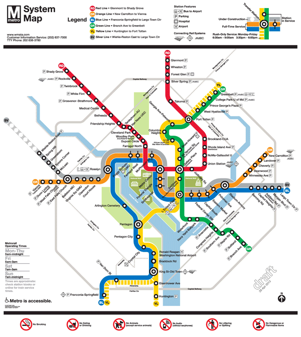
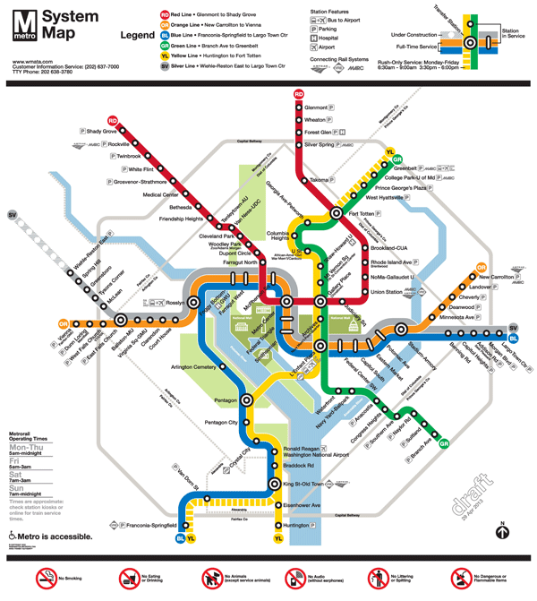
The Silver Line is coming soon, so Metro and original Metrorail map designer Lance Wyman are updating the current map.  Based on extensive customer feedback from the last map revision, we made some general improvements such as making street abbreviations consistent and improving the geographic accuracy of the stations where possible.  Cross streets will remain on the large version of the maps in stations and on trains, where it is most useful for customers as they are traveling on Metro. But in the interest of readability and streamlining, we will keep cross streets off smaller versions of the map often found online and in printed materials.

The first draft of the map (Map 1) also featured 14 percent thinner lines to help readability, now that the Silver Line will travel through DC, and a new station icon with lines that extended across all three rail colors.  This version also included the new Silver Line station names for Phase 1.

When we asked for feedback on the draft earlier this year, here’s what you told us: try even thinner lines, explore other station dot options, and “Center” and “Heights” should not be abbreviated.

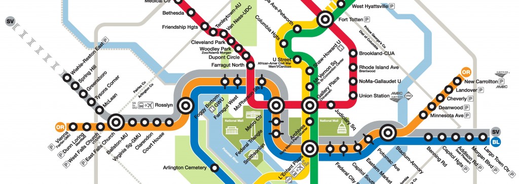
So here are two new maps for your review.  In both maps, “Center” and “Heights” are no longer abbreviated.  Map 1 below is an update of the previous draft, with slightly longer “whiskers”.  Map 2 incorporates some additional changes:

  • 24 percent thinner lines, and
  • the use of a capsule-shaped station icon.

Please compare the two maps, visible below, and let us know which one you prefer.

To compare the maps, slide the vertical bar across the image to show the differences between Map 1  and Map 2.  Further below you will find a zoom-in of both maps, also with the vertical slider bar for easy comparison.

All comments welcome!  Please comment below or on our  MindMixer site.  Also, check out Greater Greater Washington’s coverage of the updated map.  Thank you for your input.


2FinalTestMaps-04-29-13-12FinalTestMaps-04-29-13-2


Read more…

Categories: In The News Tags: , ,

What Will Happen to the Buses with the Silver Line?

March 18th, 2013 17 comments

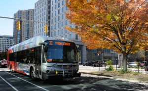
Some bus routes will change when the Silver Line arrives late this year.

Some bus routes will change when the Silver Line arrives late this year.

When the Silver Line opens, many bus lines will be reorganized – to serve the five new Metrorail stations, change routes that will become redundant, and to ensure an integrated approach to the overall bus and rail network.

The Metro Board of Directors approved the Metrobus service changes in December (details). Exact schedules are not yet  finalized but will become available as we get closer to the Silver Line opening at the end of the year.

60 bus routes serve the areas affected by the Silver Line, 13 of which are Metrobus routes. Metro has been working closely with Fairfax Connector, Loudoun County, and other operators to be sure all the changes work together and make sense. Generally, here’s what to expect:

  • All 5 new Silver Line stations will have bus service
  • Many Metrobus routes will be re-routed to serve the Tysons Corner area. Affected routes include the 1C, 2A, 2B, 2C, 2G, 2T, 3A-E, 3T, 15K, 15L, 15M, 23A, 23C, 24T, 28A, 28T, and 28X.  (See the more detailed Metrobus proposal).
  • A circulator bus system will serve the Tysons area, including the new Silver Line stations in Tysons
  • Many Fairfax Connector buses connecting Reston and Herndon to West Falls Church station will now serve the Wiehle Avenue Silver Line station
  • 7 Loudoun County buses will move from West Falls Church to Wiehle Avenue station
  • 3 Prince William County buses will move to Tysons Corner station
  • Going to Dulles Airport? Metrobus 5A will remain unchanged, and the express Washington Flyer buses will move from West Falls Church to Wiehle Avenue station.

When does all this happen? All bus changes will need to take effect by the first day of Silver Line operations!

For more information on Fairfax County bus changes in particular, visit their extensive website on the Silver Line changes.

Categories: In The News Tags: , ,

What Will Happen to the rail schedules with the Silver Line?

March 12th, 2013 25 comments

DullesMap.02.05.13+v4+-+cropped

When the Silver Line opens, Metro will adjust the rail schedule to accommodate increased service. What will change, and how will it affect you?

The Silver Line, which will run from Reston and Tyson’s Corner to Largo Town Center, will bring a net increase in rail service. But exactly how will it affect you? That depends on when you travel.

At peak times, Metro will need to make a few adjustments to make room for the Silver Line. The map below shows where the number of trains goes up, down, or stays the same. Metro’s main constraint is at Rosslyn, where three lines – Orange, Blue, and Silver – come together. At Rosslyn and into downtown, Metro can handle a maximum of 26 trains per hour, or a train every 2 minutes and 20 seconds or so.  (To keep things simple, this blog post uses the AM peak hour to illustrate peak rail changes).  In a nutshell, the Silver Line rail operating plan will:

  • Add Silver Line trains every 6 minutes,
  • Redirect 2 more Blue Line trains per hour onto the Yellow Line,
  • Convert some Orange Line trains from Vienna to Silver Line trains,
  • Discontinue some one-way Orange Line trains we currently run (called “trippers”) because they will be replaced by Silver Line trains.

As a result, service will increase in several places, shown in green below: Read more…

Categories: In The News Tags: , ,

What is the Silver Line, and Where Will it Go?

March 11th, 2013 7 comments

New Silver Line stations opening around the end of 2013. (Click for full map)

New Silver Line stations (Click for full map)

You may have heard about the Silver Line – but what is it, and where will it go? What’s nearby the new stations? To go along with the open houses on the Silver Line this week, here’s a primer on some Silver Line basics:

What is the Silver Line? A new Metrorail extension in Virginia serving Tysons Corner and Reston.  Phase 1 is nearing completion now and will open around December 2013. Phase 2 is just beginning construction, and will serve Dulles International Airport and beyond. Because the line serves the Dulles corridor and will eventually serve the Airport, the Silver Line is sometimes called the “Dulles Corridor Metrorail Extension.”

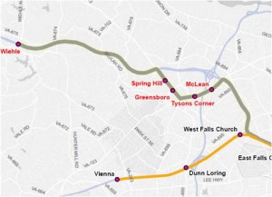
Where will the Silver Line go? The new tracks will branch off from the Orange Line between East Falls Church and West Falls Church. There will be five new stations in Phase 1 – four clustered around Tysons Corner, and one farther west at Wiehle Avenue in Reston. Phase 2 will reach Dulles Airport and beyond in several years.

Read more…

Categories: In The News Tags: ,