Posts Tagged ‘planning’

Transit Today, Tomorrow, and Beyond: There’s More to It Than Metrorail

July 6th, 2015 1 comment

In part one of this series, Metro Planners led a session at StreetsCamp  Saturday June 20, 2015 to talk with transit advocates about other possibilities beyond Metrorail to increase transit use, reach, and access.

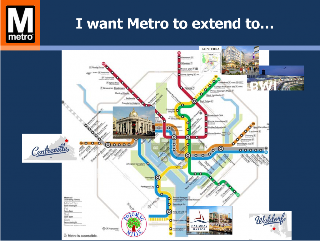
I want Metro to...

Politicians and citizens always ask for more Metrorail, but why should transit continue to chase land use decisions? Metro Planners Allison Davis and Kristin Haldeman talked to transit advocates and urbanists at StreetsCamp last Saturday to provide approaches that can help the transit we have today reach more people and be more cost-effective without requiring more Metrorail (pdf). The major take-aways for advocates and urbanists were to advocate for:

(1)    Local decision makers to monetize full life‐cycle cost of land use options;

(2)    Access projects that create comfortable (i.e. desirable) paths for pedestrians and bicyclists; and

(3)    Local jurisdictions to add transit signal priority, queue jumps, and bus lanes

Why these three specifically? Read more…

Metrobus U and V Lines Changes in Effect June 21

June 15th, 2015 Comments off

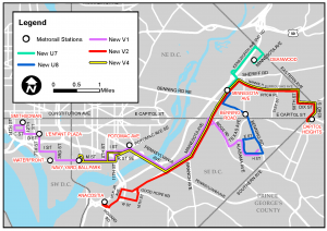
The U and V Lines have been overhauled as part of Metrobus’ June 21 service changes. Here’s what you need to know about the new and eliminated U and V routes.

In April 2014, Metrobus Planning staff directed a study of the U and V lines. The routes (U2, U4, U5, U6, U8, V7, V8, and V9), operate primarily in the District of Columbia, connecting the Minnesota Avenue Metrorail station with nearby neighborhoods. The study assessed the lines in detail, identified traffic issues and crowding concerns, and recommended service changes. As a result of the 2014 study, we have restructured the U and V lines to make them clearer and more reliable.

U_V_All_Lines_Final_June_2015_Brochure

The following changes are effective Sunday, June 21, 2015:

  • the elimination of Routes U2, V7, and V8,
  • the shortening of Route U8,
  • the restructuring of Route V9 as the new Route V1, and
  • the addition of new routes U7, V1, V2, and V4.

Take a look at our detailed U and V Line brochure and the new timetables (U7U8V1, and V2,4) and let us know what you think of the new service.

There are no changes to the other U and V routes (U4, U5, U6, and V5).

This post is Part 2 of 4 in a series spotlighting major changes from Metrobus’ June 2015 Service Change. 

Categories: Service Changes Tags: , , , , , , , , , , , ,

Quarterly Metrobus Service Change Takes Effect June 21

June 12th, 2015 1 comment

Metro’s bus planners always aim to provide you with a Better Bus, and on June 21, timetables are changing for over 40 bus routes. Here’s what you need to know, starting with a closer look at the NH1,  NH3 line.

This post is Part 1 of 4 in a series spotlighting major changes from Metrobus’ June 2015 Service Change. Stay tuned for details on the revised E Line, U and V Lines, and 22 and 25 Lines.

Metrobus planners are constantly reviewing bus service and routes and bringing changes four times a year. Regular assessments including daily weekday passenger boardings and passengers per revenue trip, along with data from customer participation and feedback from our Metrobus operators, point out routes that need attention. Sometimes the resulting changes are small, such as adjusting trip times to more evenly space trips and better accommodate passenger loads or adjusting to traffic patterns. Other changes have a bigger impact, perhaps influenced by passenger demand, construction detours, budget constraints, or political pressures. No matter the reason, Metro Bus Planning is always working for a Better Bus.

Here’s what’s happening with the June 2015 service changes (detailed future timetables are available too): Read more…

Planning Tool Update Sheds Light on Rail Car Crowding Distribution

May 18th, 2015 19 comments

Latest version of Line Load tool will feature modeled car-crowding numbers.

Many factors influence which car number of a Metrorail train a customer rides.  Infrequent riders may wait for the train near the escalator and board the nearest rail car. Savvier customers may prefer to ensure they are the first to exit at their destination station or have an shorter walk at a transfer station.  Others may board cars based on understanding where seats are more likely to be available.  All of this activity can result in uneven loading of Metrorail cars across a given train, with some rail cars crowded and others near empty.

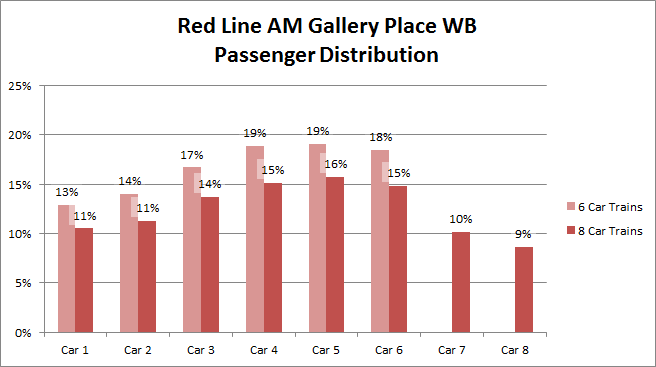
As we mentioned in 2013, the Office of Planning has an in-house tool that allows planners to estimate how crowded trains are based on origin-destination ridership data. Currently we are in the midst of a few updates, which will include the Silver Line that opened last year.  Another of the new features that we are excited about is a rail car crowding analysis for the system’s most critical segments.  Based on over six months of rail car-crowding data that was collected at selected stations by rail passenger “checkers,” the train-based ridership data will be distributed across the cars so we can estimate what kind of crowding we have by car number, at the peak load points. The following graph illustrates the observed car crowding variations at Gallery Place.

carcrowding

Customers may experience crowded conditions even when the average rail passenger per car (PPC) numbers (PDF) would indicate otherwise. This new feature is an important addition that will help Metro planners better understand the customer experience.  The car crowding analysis will begin to identify which cars of a train tend to be crowded in the peak hours, and which are less crowded.  This information will the be used as a starting point for devising strategies for better spreading customers across all cars of a train.

How do you choose which rail car you ride in?  Other than berthing trains at the center of the platform (see this informative article over at Greater Greater Washington on that topic), what strategies might Metro consider to better balance customers across rail cars?


Do You Bike to Metro in Fairfax County? Your input is needed!

April 28th, 2015 Comments off

Fairfax County seeks input from bike-and-ride commuters.

Bike FairfaxAs we have discussed previously, safe and convenient pedestrian and bicycle access is critical to Metro’s success, and WMATA works closely with local jurisdictions to find ways to improve conditions for customers arriving on foot or bike. Compared with the high expense of building more parking garages for park-and-ride customers, investing in better walking and biking infrastructure is an incredibly cost-effective way of attracting Metro customers. On Metro station property, WMATA is making investments such as bike parking and path improvements.  On the public streets beyond, our local and state partners are installing their own new facilities for people walking/biking to the station. Read more…

Metrorail: A Long-Term Solution

April 20th, 2015 12 comments

Metrorail has had a huge impact on the region, but as we’ve seen with the Silver Line, it can take decades to get from concept to execution.

One of the questions I hear most often as a planner for Metro is When will a Metro station open in xyz neighborhood, “in Georgetown”, or “at BWI”? It was the first question at the March Citizens Association of Georgetown meeting. My response — “Decades” — often elicits audible groans.

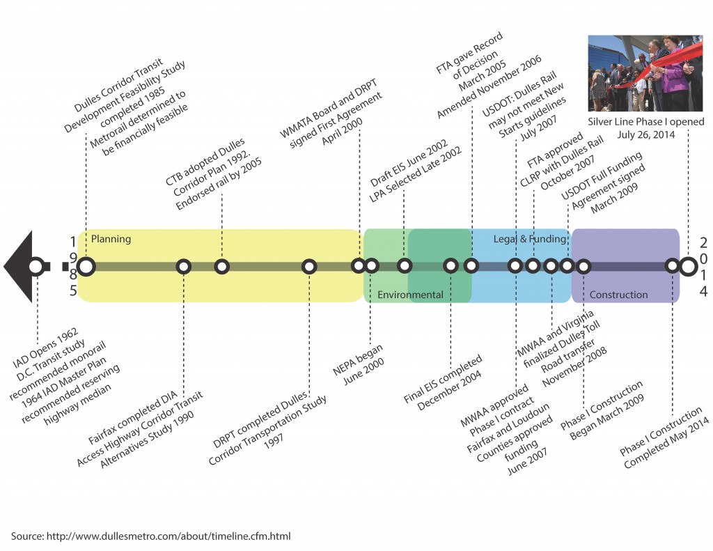
Given last summer’s opening of the Silver Line, we have a case study that can provide insight on how long it takes to plan, fund, and construct large infrastructure projects. The Dulles Corridor Metrorail Project has done a phenomenal job of maintaining a project timeline. Since the region has many recent newcomers, it is helpful to revisit many of the key milestones, as shown below. It is also helpful to remind readers that the Metropolitan Washington Airports Authority (MWAA) was the ultimate developer of the Silver Line (both Phases I and II) and that the project “only” required cooperation among the Commonwealth of Virginia, MWAA, Metro, the federal government, and Fairfax and Loudoun Counties. While just one example, the Silver Line’s long story is not vastly different from other mega-projects happening in the region and across the country.

Timeline for Planning, Environmental Process, Legal and Financing, and Constructing the Silver Line

Read more…

Metro’s Public Participation Plan Wins Planning Award

December 3rd, 2014 Comments off

Major Award!

Major Award!

Over the last 18 months, Metro has been developing a Public Participation Plan (PPP) (.pdf, 4MB) to help us tailor our outreach strategies to the many diverse groups in our service area to ensure there are opportunities for all groups to be meaningfully engaged in Metro’s planning and programming activities.  It was quite the effort, but resulted in a plan we can be very proud of and are ready to implement!  It turns out the National Capital Area Chapter of the American Planning Association thinks so too, as our PPP received their 2014 Award for Distinction in Community Outreach and Engagement.  We feel very honored to have been chosen from applicants throughout the National Capital Area.

Read more…

Why isn’t Metro looking at a line to [insert address here]?

December 20th, 2013 10 comments

[Editor’s note: this will be our last post of 2013.  We look forward to seeing you again in early January.]

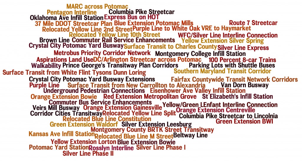
You name it and we tested it as part of our analysis and development of the Regional Transit System Plan (RTSP). Here’s the comprehensive list of what was analyzed.

List of Transit Corridors, Projects, and Plans Analyzed as Part of RTSP

List of Transit Corridors, Projects, and Plans Analyzed as Part of RTSP

We have received tons of great comments on the proposed 2040 network of Metrorail and high capacity surface transit corridors. Many of you have said that we missed <insert corridor here> or have asked why we don’t have a line to <insert address here>. As part of this plan, we have analyzed almost every corridor or mode that you have identified. However, we recognize that most of it was behind the scenes and is buried deep in our posted presentations to the Technical Advisory Group (TAG).

Above is a list of what was analyzed before we unveiled the proposed 2040 Metrorail Network and regionally significant high capacity corridors. Better yet, here is a document that shows the Metrorail lines and other surface transit plans, projects, and strategies that were tested over the course of the project. Everything is listed and where possible, maps and graphics are provided to illustrate what was tested. All tested items were measured against a comprehensive set of measures of effectiveness (MOE). The MOEs assessed ridership, impact on core capacity, transfers, reduction in vehicle miles traveled (VMT), mode share, etc.

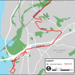
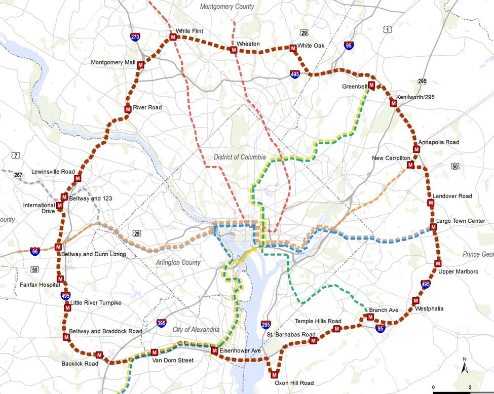
To wet your whistle, below, check out the Beltway Line that was tested. Only the segments that crossed the American Legion Bridge (between White Flint and Dunn Loring) and the Woodrow Wilson Bridge (between Branch Avenue and Eisenhower Avenue) had some promise and therefore, they continued on in the analysis, though as surface transit not Metrorail. The other segments did not provide good ridership, primarily due to the low densities within a walkable distance from the Beltway, and had little impact on Metrorail core capacity.

Alignment of a Beltway Line that was tested in the RTSP

Alignment of a Beltway Line that was tested in the RTSP

Let us know what you think!

More than Metrorail: The Region’s Most Important High-Capacity Surface Transit Corridors

December 19th, 2013 14 comments

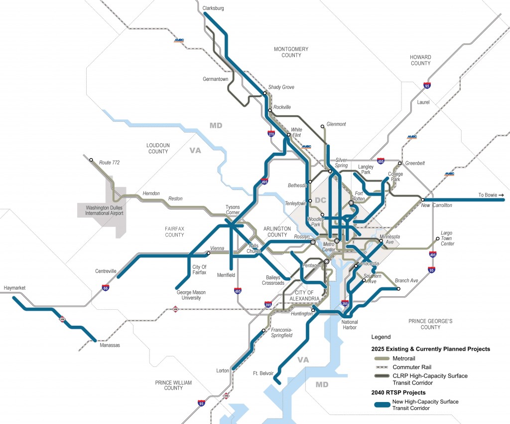
In parallel with the proposed 2040 Metrorail network, we have identified 25 regionally significant corridors that merit high-capacity surface transit by 2040. Depending on the corridor, high-capacity surface transit can be provided more efficiently and effectively by modes other than Metrorail.

The best transit systems in the world are comprised of large networks served by multiple modes. In the National Capital Region, due to the growth and dispersal of activity centers, the high demand placed on Metrorail, and the realities of transit funding, expanding the transit network needs to occur by expanding transit on the region’s roads and highways not just by Metrorail. Metrorail is not and cannot be the best mode for every corridor because the vast majority of corridors do not have the land use, density and ridership to support it.

But don’t despair! There are plenty of other high-capacity modes such as bus rapid transit (BRT), light rail (LRT), streetcar, and enhanced bus that can provide:

  • high-frequency;
  • all day service;
  • large, comfortable vehicles; and
  • lower capital and operating costs than Metrorail.

Regionally Significant High Capacity Surface Transit Corridors as part of 2040 Regional Transit System Plan

Regionally Significant High-Capacity Surface Transit Corridors as part of 2040 Regional Transit System Plan

Read more…

Proposed 2040 Metrorail Network

December 5th, 2013 91 comments

Step right up and check out the proposed 2040 core Metrorail configuration with new Blue and Yellow Lines and a third line in Virginia!
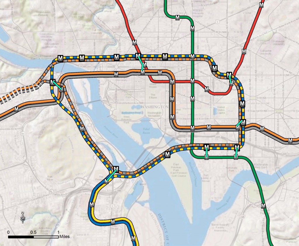
Proposed 2040 Metrorail Core Configuration
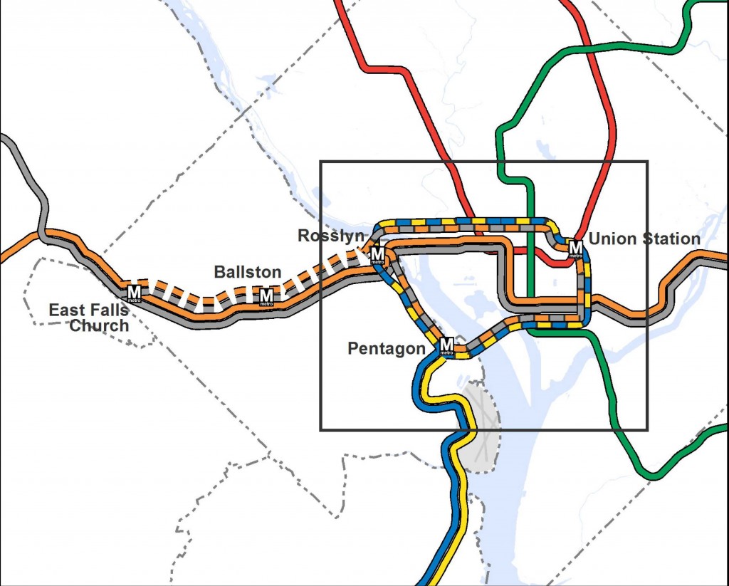
Proposed 2040 Metrorail Core Configuration

Proposed 2040 Metrorail Network

Proposed 2040 Metrorail Network

What does this network do? The proposed rail network shown above is expected to reduce future crowding on Metrorail, provide enough capacity for future development, and expand the reach of transit in the region, especially to regional activity centers.

Why are we proposing it? This rail network is part of the 2040 Regional Transit System Plan (RTSP). Its purpose is to develop the rail and surface transit network for 2040 that meets the needs of the growing Washington DC region.

What else have we considered? About a month ago, we posted about some of the possible long-range changes to the Metrorail core that we are considering as part of the RTSP. We analyzed four different core configurations, gathered your comments, and the final configuration for the core is shown above. As many of you commented, it is a combination of two of the scenarios (Scenarios B and C).

Next Steps: The next and final step for the RTSP is to use this configuration, along with the high capacity surface corridors, to conduct a final round of analysis. The output will provide us with information on ridership, mode share, levels of crowding, transfers, etc. and ultimately a final network for 2040.

Let us know what you think!

A few extra notes:

(1) The Metrorail network shown in this post will be layered with an extensive high capacity surface transit network to expand transit and meet the needs of employment and population growth in the region.

(2) For the plan to have validity and acceptability across the region and within the federal planning process, it is based on the region’s adopted cooperative land use forecast for 2040. We used the Aspirations Land Use scenario to stress test the core of the system, but ultimately the plan needs to start with the region’s adopted land use. As follow on work to this plan, we will be testing different land uses to see what else we can learn to improve long-range plans.

(3) All of the lines shown, as well as all of the high capacity surface transit corridors, will need corridor studies, alternatives analyses, and full engineering studies. This cannot be done at a regional level, but would need to happen on a project by project, line by line level. So, while we are showing a new Blue Line on M Street, it very well could be on N or P Streets.