Posts Tagged ‘planning’

Sneak Peak of Metro Activities at the 95th TRB Annual Meeting

January 7th, 2016 No comments

The 95th Transportation Research Board (TRB) annual meeting is coming to town!  This annual meeting will host 12,000 transportation professionals from around the world and more than 5,000 presentations covering all transportation modes, including public transportation. At the 2016 annual meeting, Metro staff will be sharing Metro’s experience and best practices on a number of transit development and planning initiatives.

Jordan from the Office of Performance will introduce the development of a new performance measure of travel time reliability (Event 823: Where is My Ride?).  This new measure can be used by customers to better plan their trips and by Metro to optimize rail operations. Read more…

Monitoring Passengers Loads on Metrorail – Using New Tools to Examine the Data

January 5th, 2016 8 comments

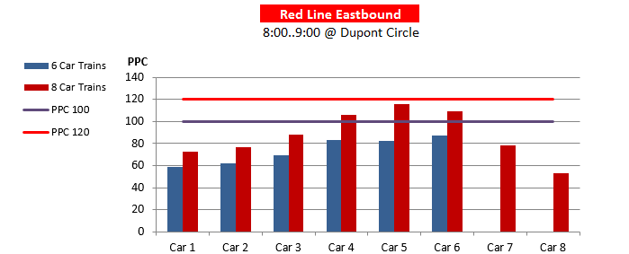
The new version of the Line Load Application now models passengers into trains by cars. Let’s take a look at this new feature!

Remember in May when we said an updated version of the Line Load Application was coming that would include passenger distribution data at max load locations? Well it’s here now!

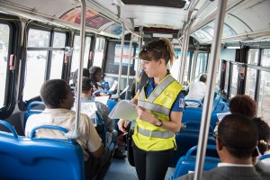
If you’ve seen Metro employees with clipboards out during rush hour at major stations, then chances are you’ve seen the Metro load checkers. These individuals mark down the loads of these trains. They also mark down any people who didn’t board. Last but not least, they are also doing this by car, and with that information Metro has been keeping track of the spread of the loads on the cars at the max load stations.

carloads

Average Car Loads in the AM Peak Hour – October 2014 Weekdays – Modeled Distribution of Passengers at Dupont Circle **The estimated railcar crowding is based on the scheduled Red Line service.

Read more…

Squaring Circles: De-Mystifying Metro’s Budget and Funding Sources (Part One of Three)

January 4th, 2016 Comments off

One of the most critical issues facing public transportation is how to pay for it. In a short series of blog posts, we’ll try to explain Metro’s finances and give you tools to engage in budget discussions. 

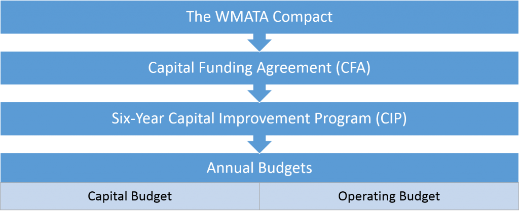
No matter where you stand on the question of supporting or using public transportation, one of the loudest and most constant debates is how to pay for it. It’s a complicated question that combines values, politics, resources, and legal obligations. It also revolves around the technicalities of multiple funding sources (fares, grants, taxes) and how those sources can be spent (allowable types of projects, legal requirements, matching funds, etc.). Most people probably know Metro operates under a yearly budget. However, that annual budget and Metro’s ability to raise and spend funds is shaped by a larger policy and planning framework. This initial post focuses on three pillars of that policy framework: the WMATA Compact, the Capital Funding Agreement (CFA), and the six-year Capital Improvement Program (CIP). It also summarizes the annual budget planning process.

Funding policy context

WMATA’s funding policy framework

Read more…

ConnectGreaterWashington – a Vision for a Responsible and Prosperous Future (Part 2)

December 1st, 2015 Comments off

Investing in the region’s activity centers that have high-capacity, high-frequency transit and enhancing them as proposed in the Place+Opportunity report is part and parcel to preserving the economic competitiveness of the region AND creating a financially-sustainable Metrorail system.

(This post is part of a multi-part series about Logo_WMATA_CWG_001 black-01ConnectGreaterWashington and the study’s application of land use as a transportation strategy. Part one of the series discussed why Metro cares about land use and the potential benefits of assessing growth from a regional perspective. Part two below outlines the study’s goals, assumptions, and approach.)
WMATA planners posited that changes to local jurisdictions’ and/or the region’s approach to land use and other policies would enable better use of the transportation system this region already built rather than require it to spend billions on new projects. Money is not falling from trees to expand transit — the region hasn’t even agreed to fund enough rail cars to run all eight car trains! So, if the region can’t (or won’t) invest in transit to keep up with growth, then we need to carefully evaluate how the growth we are forecasting can use the infrastructure we already have. Can the region’s growth, rather than necessitate billions of dollars in new infrastructure, be thoughtfully planned to better utilize the roadway and transit systems we already have? What would that mean to the region, its finances, and to Metro’s operating subsidies that its funding partners pay annually?

We developed an Executive Summary (pdf) that summarizes our approach and findings. These posts are infinitely more detailed, but you can certainly glean the key points from the Executive Summary.

The Basics

First and foremost, this study did not seek to develop an optimal land use or in any way socially engineer where future population and jobs should go. These are “what if” scenarios to provide context, data, and information to citizens, decision makers, and elected officials as the region grapples with future job and population growth, demand for transit, and development of walkable communities. This study sought to consider where future growth could go, and worked only with the regional growth anticipated to exist in this region in forecasts from 2020 through 2040. The modeling left existing jobs and population exactly where they exist today and was mindful that anything already in the development pipeline was far enough along to be assumed as “in place”.

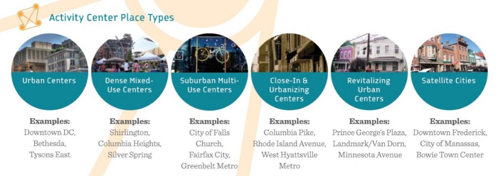
Second, we followed the place types defined in Place+Opportunity as they were identified, developed, and defined by local jurisdictional planning staff and the Metropolitan Washington Council of Governments (MWCOG). Why? Because we wanted this study to be as realistic as possible and remain true to the nature of the activity centers and the jurisdictions that informed their types and densities. Additionally, Place+Opportunity was completed recently (2014) and had significant support and direct input from the jurisdictions and the region.
 

Place+Opportunity Place Types

Place+Opportunity Place Types

Read more…

Board Approves 2015 Bus SOGO

November 20th, 2015 Comments off

State of Good Operations (SOGO) changes coming to a Metrobus route near you.

Metrobus planning presented the annual 2015 Bus State of Good Operations recommendations (PDF) to the Board on November 19. The package was approved and customers will see some changes starting in December. The remainder of the changes will roll out with Metrobus’ March and June schedule changes. 

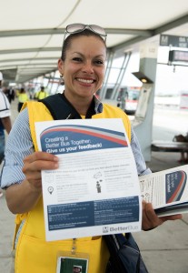
Staff provided SOGO proposal information at outreach events and pop ups, including at the Pentagon Transit Center

Staff provided SOGO proposal information at outreach events and pop ups, including at the Pentagon Transit Center, photo by WMATA

The annual SOGO process seeks board approval for changes to Metrobus service. Every year,  planners put together a comprehensive list of Metrobus routes they want to improve in the coming year. Any major service change must be approved by the board. A major Metrobus service change is defined as

  • Change in span of service on a line of more than one hour in a single fiscal year,
  • Change in revenue miles on a line of more than 20% in a single fiscal year,
  • Change in route miles on a line of 15% in a single fiscal year, or
  • Projected change of 10% of the riders on a line in a single fiscal year.

This year, planners were tasked with improving service, reliability, travel time, and crowding while keeping the proposals budget and cost neutral.  The recommendations must not have a disparate impact on minority populations or a disproportionate burden on low income populations. Read more…

Beyond Borders – Acting Regionally to Create a Financially-Sustainable Transit System (Part One)

November 9th, 2015 Comments off

What if taxpayers could avoid spending hundreds of millions of dollars annually on Metro’s operating subsidy? Better yet – what if Metro could pay for itself and have enough left over to fund local transportation projects? What if better using the transit system we already have could help us achieve this?  This isn’t just wishful thinking – it is possible.

Logo_WMATA_CWG_001 black-01(This is the first post in a series of posts that assess applying land use as a transportation strategy)
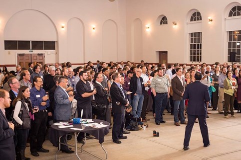
Recently some of the Washington region’s prominent leaders issued a call to action for this region to cease competing against itself if it is to secure its economic future.  Their courageous statement coincided with findings from WMATA’s Office of Planning that actually put a price tag on that promise.  And it’s a doozy.  In case you missed it, at the Coalition for Smarter Growth‘s Smart Growth Social recently, Shyam Kannan, Metro’s Managing Director of Planning, gave a presentation on the impact of regional cooperation on the region’s finances and specifically, what this could mean for Metro and its ridership, operating subsidy, funding partners, and taxpayers.

What he presented is the second half of ConnectGreaterWashington (CGW).  As a reminder, the first part of CGW was a long range plan that identified infrastructure expansion needs across all transit operators in the region. It assumed that we would grow as the local jurisdictions have estimated in the cooperative forecast. This second part asks a different question.  It challenges us to make do with the transportation system we have already built. Can the region’s growth, rather than necessitate billions of dollars in new infrastructure, be distributed differently to better utilize the roadway and transit systems we already have? What would that mean to the region, its finances, and to Metro’s operating subsidies that its funding partners pay annually?

So the study contemplates, compares, and contrasts two distinct paths.  Grow the way we have been growing and build our way out of congestion.  Or choose to grow around our existing infrastructure and use it to its maximum capacity.  In the coming weeks, we will be posting the detailed analysis here on PlanItMetro. It’s lengthy and wonky, so be prepared for a series of in-depth posts. Read more…

In Case You Missed It – Presentation from Last Week’s Smart Growth Social

October 22nd, 2015 Comments off

We’ve published online the WMATA presentation from last week’s Smart Growth Social.

Last week the Coalition for Smarter Growth held their annual Smart Growth Social. Over 200 people were in attendance that evening and WMATA was honored to have the opportunity to share with the audience a preview of some ground-breaking research the Office of Planning has been conducting into the impact of Smart Growth practices on the region’s finances. On behalf of everyone who works towards a more sustainable and prosperous region, thank you for listening.


We’ve gotten a ton of requests for copies of the presentation, which we have made available online. If you want to get more information on how smarter land use planning can and should be this region’s top transportation strategy, feel free to use the presentation or email us (planning@wmata.com) to stay informed as we release more information on ConnectGreaterWashington later this year.

Metrobus is Collecting Your Input for Annual Bus Service Adjustments

September 15th, 2015 3 comments

Time is running out to provide your input on proposed Metrobus changes.

Every year, Metrobus planners propose service changes to maintain a Bus State of Good Operations (SOGO). This year’s official public participation period went live on Saturday, August 15 and will close at 5:00pm on Wednesday, September 23.  That’s less than two weeks away!

Halfway through the public comment period, we thought we would give you sense of the process so far.

  • More than 3,000 online surveys have been completed.  Two-thirds of these returns are from direct email outreach to customers using affected routes. If you are interested in receiving invitations to similar online surveys in the future, please register your SmarTrip card.

    Bus SOGO outreach 2015

    Bus SOGO outreach 2015

  • With more than 20 outreach events completed or scheduled, we are collecting feedback by going straight to the customer.  Metro staff is out riding buses and showing up at bus stops and rail stations.  We understand not everyone can go online so we are coming to them.  Look for us and help us improve your bus experience.
  • These outreach activities have resulted in more than 2,000 written comments from customers all over the region.
  • At the time of this writing, the elimination of the 5A is not being well received nor is the elimination of the segment between McPherson Square and Kennedy Center on the Route 80.  Many in the District are giving favorable marks to the free transfer between Capitol Heights/Addison Road Metrorail stations for select routes.  Maryland customers are also excited for the Q Line free transfer to and from the Metrorail Red Line between Wheaton and Silver Spring.
  • In addition to English-language replies, we have received completed surveys from Spanish, Vietnamese, and Amharic speakers.  Customers from all economic and ethnic groups are chiming in as well.

We want to hear more from our customers to see how these changes would affect your travel choices. Let us know how major service changes would impact you. Join the conversation by reading the official docket and submitting your thoughts online or in person.

-Email your comments to writtentestimony@wmata.com
-Talk to Metro staff at a pop-up event
Take an online survey
-Attend the public hearing on Thursday, September 17 at WMATA HQ (600 5th St NW, Washington, DC 20001).

Since Time is Money, Metro Wants a Business Partner to Help Metrobus Go More and Stop Less

September 11th, 2015 3 comments

Metro is exploring opportunities to partner with a private company or investor to pilot off-board SmarTrip® loading to help improve customer travel times and lower our operating costs.

Metrobus speeds have steadily decreased over time as the region grew and traffic worsened. This not only negatively impacts Metro customers, but also increases our operating costs. As traffic congestion erodes bus speeds, we need to deploy more vehicles and operators on the busiest routes in order to maintain service frequencies. We know that behind the statistics stand legions of bus riders who want faster service, as well as counties and cities that want lower bills for that service.

Crowded boarding and long dwell times

Crowded boarding and long dwell times

Off-Board Fare Payment and Transit Prioritization

There is no silver bullet to speed up transit. Instead, agencies can use a combination of technology and on-street treatments to increase bus speeds and move more passengers. One of the few prioritization strategies Metro can undertake on its own is allowing off-board fare loading, moving all SmarTrip® value loading from the farebox to kiosks near bus stops. This would reduce the amount of time it takes for passengers to board buses and pay fares, in turn speeding up bus trips.  We have looked into this in the past and have recently revisited this important concept. Read more…

How Smarter Urban Planning Can Help the Chesapeake Bay

July 20th, 2015 Comments off

Better urban planning can help save our rivers and the Chesapeake Bay—by reducing this region’s future impervious surfaces by 20%. Here’s why.

As many Washingtonians know, the Chesapeake Bay needs help. Dead zones and algae blooms appear every summer which destroy aquatic life in the Bay and threaten  fishing, swimming, and economic health.  A major contributor to this problem is rainwater runoff from paved roads, parking lots, and roofs.  These are called “impermeable surfaces”.  In contrast, permeable (or pervious) surface is one through which liquids are able to pass.

Grassy fields, woodlands and farmlands are excellent examples of this: rainwater or snowmelt soaks into the ground, pollutants in the water are filtered naturally, and excess water travels underground to streams and eventually (in the Washington region) the Chesapeake Bay.Rainfall that falls on impervious surfaces like paved roads, parking lots and roofs “runs off” unfiltered making its way to the Chesapeake Bay—along with nitrogen and sulfur oxides from vehicle emissions, motor oil, and road salt residue.  


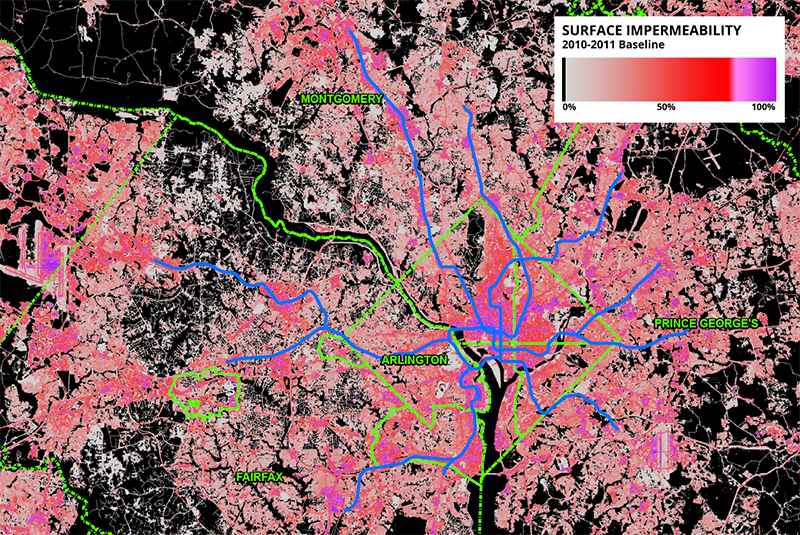
Figure 1 – Map of impermeability throughout the region with overlaid jurisdictional boundaries and Metrorail system for reference. Note the concentrations of highly-impermeable surfaces in central DC and at Dulles.

Figure 1 – Map of impermeability throughout the region with overlaid jurisdictional boundaries and Metrorail system for reference. Note the concentrations of highly-impermeable surfaces in central D.C., and at other activity centers like Dulles.

Read more…