Posts Tagged ‘Metrorail’

What Metro 2025 Means to Virginia

March 20th, 2014 1 comment

Metro 2025 would bring significant benefits to northern Virginia, allowing the region to thrive economically while preserving regional vitality.

Think Metro’s Momentum plan is all about “downtown?” Think again! Our seven Metro 2025 initiatives – from eight-car trains to bus-only lanes will bring dramatic improvements to the quality of life and transportation to northern Virginia.


Benefits Icons_Expansion

Supports Virginia Transit Projects

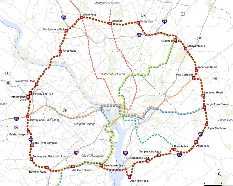
Virginia is planning big for transit, which is great – but all of the planned projects rely on a robust Metrorail and Metrobus “backbone” to succeed:

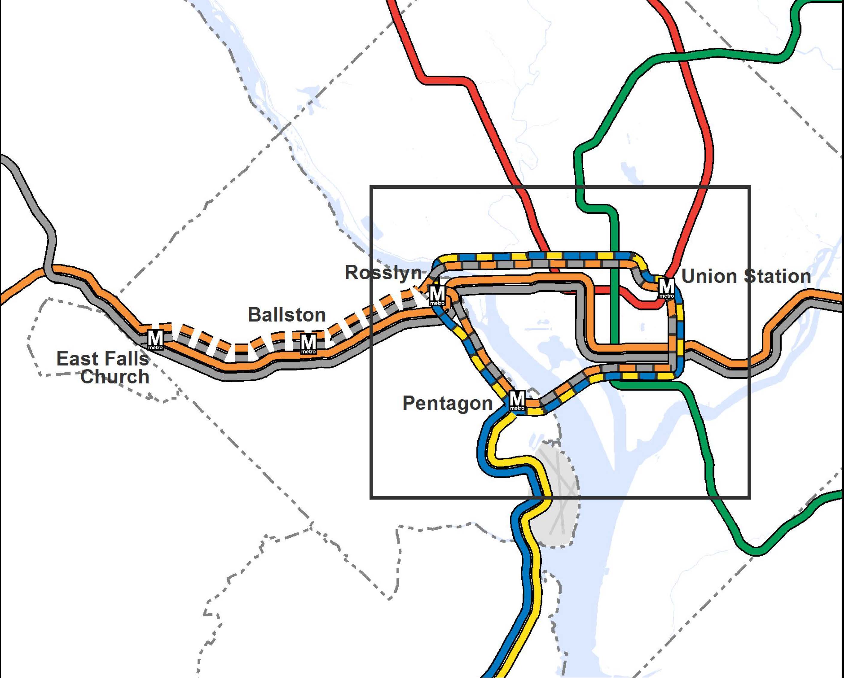
  • The Silver Line extends Metrorail by over 20 miles, and will generate tens of thousands of new riders per day when Phase II opens – many of whom will travel into Metrorail’s already congested core.
  • The Columbia Pike Streetcar will transfer 32,000 riders per day to and from Metrorail at Pentagon City – at a point in the system that is already maxxed out.
  • Two other planned busways (Crystal City/Potomac Yard, and Van Dorn/Beauregard) also connect with Metrorail stations.

All major transit projects funded in the CLRP in Northern Virginia depend on the "backbone" of Metrorail and Metrobus.

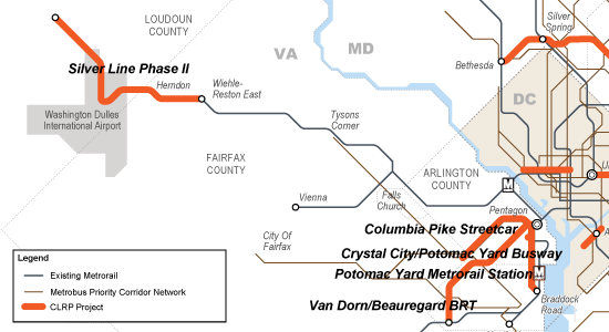
All major transit projects funded in the CLRP in Northern Virginia depend on the “backbone” of Metrorail and Metrobus.

By ensuring that Metro services can keep pace with congestion and demand, Metro 2025 is critical to making Virginia’s transit projects a success, and critical to helping the region and the state reach its transportation goals. Read more…

What Metro 2025 Means to Maryland

March 18th, 2014 1 comment

Metro 2025 would bring significant benefits to Maryland, supporting its economic growth and ensuring its future vitality.

Metro’s Momentum plan calls for seven Metro 2025 initiatives – from eight-car trains to bus-only lanes, which will bring dramatic improvements to the quality of life and transportation to Maryland.


Benefits Icons_Expansion

Ensures the Success of Maryland Transit Projects

Maryland has great plans for transit.  The Corridor Cities Transitway, the Purple Line, and the Viers Mill Rd Busway are all included in the CLRP with a reasonable expectation for funding, and the Federal Transit Administration announced recently that the Purple Line would receive $100 million in Obama’s latest FY15 budget.  Additionally, Montgomery County is developing plans for a county-wide BRT system.

These projects are worthwhile ventures, but they will always rely on the supporting regional “backbone” of Metrorail and Metrobus to deliver their intended results. At the very least, these three important projects would not connect to each other if not for Metrorail and Metrobus.  And at the very worst, if these projects are built and connect to a system that is already over capacity, they may struggle to live up to their mobility goals.

  • The Corridor Cities Transitway will function as a BRT extension of the Red Line: 1,500 people per peak hour will transfer to Metrorail at Shady Grove by 2030. (For context, about 3,000 riders per peak hour enter Shady Grove in the peak hour today.)
  • The Viers Mill Rd Busway will connect to three Metrorail stations. The current Metrobus Q-Line, a part of the Priority Corridor Network (PCN), currently provides over 8,800 trips per day, including approximately 800 transfers a day to Metrorail.
  • 10,000 Purple Line riders per day will come to and from Metrorail, where the Purple Line connects to the Red, Green, and Orange lines. Many of these passengers will further strain the over-congested lines of the rail network.

x

Funded Maryland transit projects, in the CLRP.

By ensuring that Metro services can keep pace with congestion and demand, Metro 2025 is critical to making Maryland’s transit projects a success, and critical to helping the region and the state reach its transportation goals.


Benefits Icons_Support Growth

Supports Maryland’s Growth Prospects

Maryland’s population in the Compact region is growing steadily and projected to continue growing. This growth is crucial to the economy of the state – 40% of Maryland’s state economic output came from the Washington region’s suburbs in 2012.  With that growth comes significant transportation needs, and Metro 2025 is critical to meeting that growth.

When congestion goes up, job growth goes down, and if Maryland wants to see growth potential turn into actual jobs, it needs to tame congestion.  Simply, Maryland needs the mobility that Metro 2025 would deliver: 8-car trains capable of moving the equivalent of 16-18 lanes of highways (in each direction) and connect Maryland to other regional job centers, superior bus service that can create much-needed east-west connections that bypass snarling congestion, and more. Read more…

What Metro 2025 Means for the District of Columbia

March 13th, 2014 Comments off

Metro 2025 would bring significant benefits to the District of Columbia, allowing the city to thrive economically while preserving neighborhoods and downtown vitality.

Metro’s Momentum plan calls for seven Metro 2025 initiatives – from eight-car trains to bus-only lanes, which will bring dramatic improvements to the quality of life and transportation in the District.


Benefits Icons_Expansion

Supports D.C. Transit Projects

The District has committed to a 50% market share for public transportation, and is building a Streetcar and expanded Circulator network that will depend on robust Metrorail and Metrobus services. Metro concurs that the Streetcar and Circulator are worthwhile ventures, but they will always rely on the supporting regional “backbone” of Metrorail and Metrobus in order to deliver their intended results.  Consider that every single planned D.C. Streetcar line in the 22-mile system begins, ends, or connects with a Metrorail station, and the importance of sufficient capacity on Metrorail becomes quite clear.

Today, more than 100,000 people a month transfer between Metro and the Circulator.  By 2040, even the first few lines of the D.C. Streetcar (those funded in the CLRP, not even counting the full 22-mile system) are projected to generate thousands of additional transfers to Metrorail and Metrobus each day.

DC-CLRP-Projects

D.C. Streetcar projects funded in the CLRP. The planned 22-mile system would construct even more lines.

By ensuring that Metro services can keep pace with congestion and demand, Metro 2025 is critical to making D.C.’s transit projects a success, and critical to helping D.C. reach it’s transportation goals.


Benefits Icons_Support Growth

Supports D.C.’s Growing Population and Economy

The District of Columbia’s population is surging, and its economic and population growth is only projected to grow. With that growth comes significant transportation needs, and Metro 2025 is critical to Metro’s success in meeting that growth.

To handle this growth, D.C. needs the rail and bus system that Metro 2025 would deliver: 8-car trains capable of moving the equivalent of 16-18 lanes of highways into the District, superior bus service, and more. For example, Metrobus is helping the 16th Street NW corridor to grow – ridership has surged by over 5,000 trips per day, and today buses are 3% of the vehicles but move 50% of the people on that road. Read more…

Yesterday’s Metrorail Ridership: Recovering from a Snowstorm

March 5th, 2014 3 comments

Yesterday, as everyone recovered from a snowstorm, here’s what happened to Metrorail ridership.

After Monday’s snowstorm, yesterday the federal government in the Washington region issued a two-hour delayed opening, and many schools opened with a delay or remained closed. Metrobus began the morning operating on a snow emergency plan, but by afternoon had restored full service.  Here’s what that meant to Metrorail ridership:

Metrorail ridership on Tuesday, when the federal government and many schools opened with a 2-hour delay.

Metrorail ridership on Tuesday, when the federal government and many schools opened with a 2-hour delay.

Note: the prior Thursday (Feb. 27, 2014) stands in as a typical weekday above, for comparison.

It looks as if the apex of the AM peak period occurred 15 minutes later than usual.  Many riders appeared to delay travel in the morning, resulting in a much more gradual end to the morning peak.

How was your commute different on March 4?

This data is available for download (.xlsx, 13kb).

Categories: Impact Tags: , , , ,

Gut Check – Funding Metro 2025

February 24th, 2014 1 comment

Counting on the Feds alone to fund Metro ignores a long tradition of local jurisdiction funding support – and a ticking clock.

hands-pulling-dollar-bill-puzzle

Image borrowed from eRationalmarketing.com. Click for original.

As the region grapples with mounting infrastructure needs (DC, MD and VA) regional leaders are experiencing a bit of sticker shock. That’s because this region has been enjoying the benefits of massive infrastructure capacity increases in transportation, water/sewer, and power that were built in the 1970s and were designed to keep up with growth for half a century.

Those fifty years have almost run out, as has our ability to grow into the capacity built by the previous generation of leaders. And if this region is going to continue its growth trajectory into the middle of this century, we’re going to need to invest in the supporting infrastructure capacities – including funding transit capacity increases via Metro 2025.

Some have argued that funding Metro improvements is primarily responsibility of the Federal government, or at least that the Federal government should lead this effort. That line of argument syncs up neither with the past, present or future – in reality, local jurisdictions have always played a significant role in funding Metro. Let’s lay out the facts about role of local jurisdictions in funding Metro.

Those that monitor the Federal government know well that funding sources for major capital projects are in decline, and there are no guarantees to the legislative process.  Just take a look at this graphic, from the U.S. Department of Transportation’s Highway Trust Fund TickerRead more…

Transfers: Part of Every Rail Transit System

February 6th, 2014 5 comments

About a third of Metrorail customers transfer between lines to complete their trip, and this is not too far off many of our peer transit agencies.

Everyone would prefer a “one-seat ride” (aka “transfer-free ride”) from origin to destination, but for many, transfers are a necessary part of commuting life. In fact, transfers may be even beneficial. Transfers are a part of nearly every large rail transit system with multiple lines, including Metro.  As the chart below shows, 35% of Metrorail passengers change trains at some point during their journey, and that’s slightly higher – but not wildly different from – many of our peer transit systems in the U.S.

(same scale for all images) City Customers Transferring *
cities__0002_Layer-5

New York City Subway

pct-01
 cities__0003_Layer-4

WMATA Metrorail

pct-02
cities__0000_Layer-2

Boston MBTA, Subway

pct-03
 cities__0001_Layer-6

Philadelphia, SEPTA

(excl. Regional Rail)

pct-04
cities__0004_Layer-3

Chicago Transit Authority, Rail

pct-05
* Estimated rail-to-rail transfers per boarding. Data from NTD and agencies. Maps from Fake Is The New Real.

Read more…

Why isn’t Metro looking at a line to [insert address here]?

December 20th, 2013 10 comments

[Editor’s note: this will be our last post of 2013.  We look forward to seeing you again in early January.]

You name it and we tested it as part of our analysis and development of the Regional Transit System Plan (RTSP). Here’s the comprehensive list of what was analyzed.

List of Transit Corridors, Projects, and Plans Analyzed as Part of RTSP

List of Transit Corridors, Projects, and Plans Analyzed as Part of RTSP

We have received tons of great comments on the proposed 2040 network of Metrorail and high capacity surface transit corridors. Many of you have said that we missed <insert corridor here> or have asked why we don’t have a line to <insert address here>. As part of this plan, we have analyzed almost every corridor or mode that you have identified. However, we recognize that most of it was behind the scenes and is buried deep in our posted presentations to the Technical Advisory Group (TAG).

Above is a list of what was analyzed before we unveiled the proposed 2040 Metrorail Network and regionally significant high capacity corridors. Better yet, here is a document that shows the Metrorail lines and other surface transit plans, projects, and strategies that were tested over the course of the project. Everything is listed and where possible, maps and graphics are provided to illustrate what was tested. All tested items were measured against a comprehensive set of measures of effectiveness (MOE). The MOEs assessed ridership, impact on core capacity, transfers, reduction in vehicle miles traveled (VMT), mode share, etc.

To wet your whistle, below, check out the Beltway Line that was tested. Only the segments that crossed the American Legion Bridge (between White Flint and Dunn Loring) and the Woodrow Wilson Bridge (between Branch Avenue and Eisenhower Avenue) had some promise and therefore, they continued on in the analysis, though as surface transit not Metrorail. The other segments did not provide good ridership, primarily due to the low densities within a walkable distance from the Beltway, and had little impact on Metrorail core capacity.

Alignment of a Beltway Line that was tested in the RTSP

Alignment of a Beltway Line that was tested in the RTSP

Let us know what you think!

More than Metrorail: The Region’s Most Important High-Capacity Surface Transit Corridors

December 19th, 2013 14 comments

In parallel with the proposed 2040 Metrorail network, we have identified 25 regionally significant corridors that merit high-capacity surface transit by 2040. Depending on the corridor, high-capacity surface transit can be provided more efficiently and effectively by modes other than Metrorail.

The best transit systems in the world are comprised of large networks served by multiple modes. In the National Capital Region, due to the growth and dispersal of activity centers, the high demand placed on Metrorail, and the realities of transit funding, expanding the transit network needs to occur by expanding transit on the region’s roads and highways not just by Metrorail. Metrorail is not and cannot be the best mode for every corridor because the vast majority of corridors do not have the land use, density and ridership to support it.

But don’t despair! There are plenty of other high-capacity modes such as bus rapid transit (BRT), light rail (LRT), streetcar, and enhanced bus that can provide:

  • high-frequency;
  • all day service;
  • large, comfortable vehicles; and
  • lower capital and operating costs than Metrorail.

Regionally Significant High Capacity Surface Transit Corridors as part of 2040 Regional Transit System Plan

Regionally Significant High-Capacity Surface Transit Corridors as part of 2040 Regional Transit System Plan

Read more…

Proposed 2040 Metrorail Network

December 5th, 2013 91 comments

Step right up and check out the proposed 2040 core Metrorail configuration with new Blue and Yellow Lines and a third line in Virginia!

Proposed 2040 Metrorail Core Configuration

Proposed 2040 Metrorail Core Configuration

Proposed 2040 Metrorail Network

Proposed 2040 Metrorail Network

What does this network do? The proposed rail network shown above is expected to reduce future crowding on Metrorail, provide enough capacity for future development, and expand the reach of transit in the region, especially to regional activity centers.

Why are we proposing it? This rail network is part of the 2040 Regional Transit System Plan (RTSP). Its purpose is to develop the rail and surface transit network for 2040 that meets the needs of the growing Washington DC region.

What else have we considered? About a month ago, we posted about some of the possible long-range changes to the Metrorail core that we are considering as part of the RTSP. We analyzed four different core configurations, gathered your comments, and the final configuration for the core is shown above. As many of you commented, it is a combination of two of the scenarios (Scenarios B and C).

Next Steps: The next and final step for the RTSP is to use this configuration, along with the high capacity surface corridors, to conduct a final round of analysis. The output will provide us with information on ridership, mode share, levels of crowding, transfers, etc. and ultimately a final network for 2040.

Let us know what you think!

A few extra notes:

(1) The Metrorail network shown in this post will be layered with an extensive high capacity surface transit network to expand transit and meet the needs of employment and population growth in the region.

(2) For the plan to have validity and acceptability across the region and within the federal planning process, it is based on the region’s adopted cooperative land use forecast for 2040. We used the Aspirations Land Use scenario to stress test the core of the system, but ultimately the plan needs to start with the region’s adopted land use. As follow on work to this plan, we will be testing different land uses to see what else we can learn to improve long-range plans.

(3) All of the lines shown, as well as all of the high capacity surface transit corridors, will need corridor studies, alternatives analyses, and full engineering studies. This cannot be done at a regional level, but would need to happen on a project by project, line by line level. So, while we are showing a new Blue Line on M Street, it very well could be on N or P Streets.

NPR Story on Arlington County’s Successes and Importance of Metro

October 25th, 2013 2 comments

NPR’s Morning Edition yesterday highlighted Arlington County‘s success in tackling commuting challenges, particularly as a result of the decision to bring Metrorail and transit-oriented development to the Rosslyn-Ballston corridor.  

When the Metrorail system was initially designed in the early 1960s, the plan proposed running the Orange Line in the median of what would ultimately become Interstate 66. Arlington County officials lobbied hard and put forward county funds to bring the Orange Line to its existing home, under Wilson Boulevard. They foresaw the benefits of high capacity transit IN the neighborhoods, as opposed to adjacent to the neighborhoods. They also set forth zoning, planning, and other policies to ensure that the county would maximize the benefits from that decision. The NPR story talks about the results of those decisions, the shift from a post-World War II auto-dependent suburb to a vibrant, mixed-use community that has become the gold standard for many cities across the world.

Orange Line - Proposed and Actual Alignments

Orange Line – Proposed and Actual Alignments

For more background on the history, growth, and experience with transit-oriented development in the corridor, check out this powerpoint from the Arlington County Department of Community Planning, Housing and Development. Not only does it provide additional information, it has some terrific before and after photos of the different Arlington neighborhoods and how they have changed. Parkington, anyone?

If you’d like to contribute to the NPR series, you can share your commuting experience with Morning Edition – #NPRcommute.

Yesterday’s NPR story was the first in a multi-part series on how communities are tackling commuting challenges.