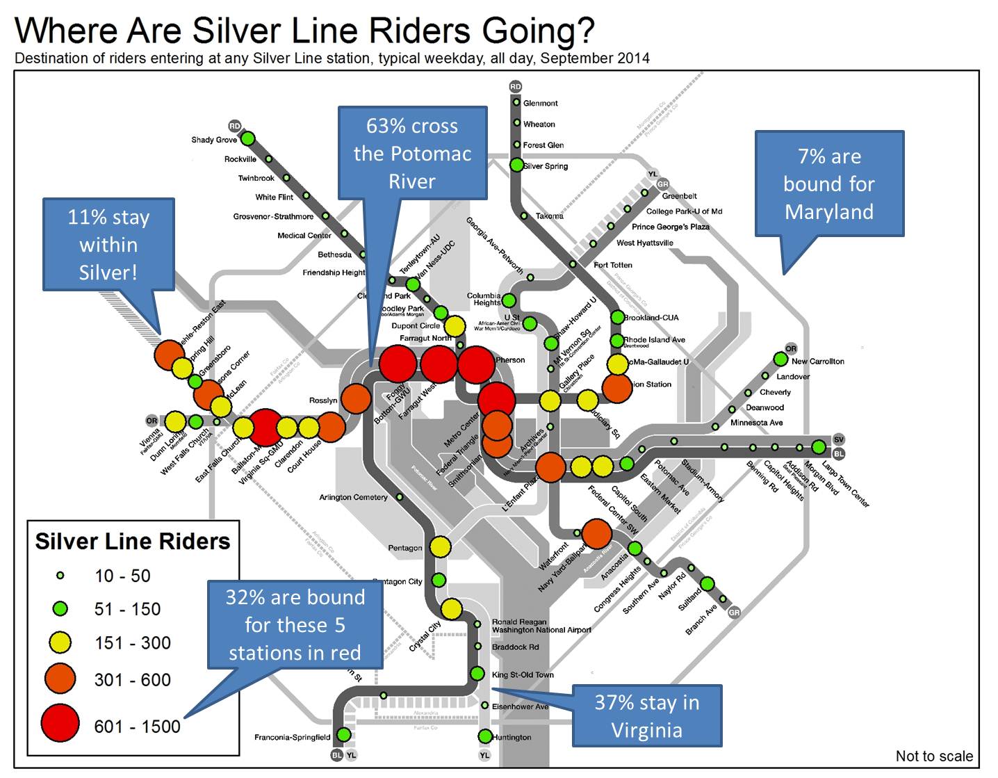
Ridership patterns on the Silver Line show that Metro’s new line is serving a truly regional market.
Now that school is back in session, the new Silver Line just completed its first full week where “normal” travel patterns are beginning to emerge. Ridership is strong, but where are these new passengers going? The diagram below shows destinations of all riders entering a Silver Line station in the week of September 8-12, 2014.

Some observations emerge from this: Read more…
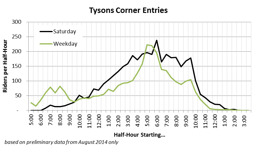
Even though Tysons Corner station on the Silver Line is only two months old, off-peak ridership is particularly strong. Saturdays are busier than weekdays, and the station stays busy past 10:00pm.
Tysons Corner station is already serving a solid reverse commute market, but ridership is also strong during midday hours, and reaches its peak during the afternoon rush and evening hours.
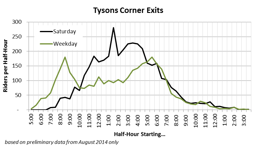
Ridership is fairly well balanced throughout the day, relative to other Metrorail stations. There’s a clear reverse commute market exiting the station during morning rush and re-entering in the evening. In the evening, however, nearly just as many people are exiting the station as are entering the stations, suggesting the commuters are mixing with other riders bound for the malls or other activities. Read more…
 May 2013 and 2014 Metrorail ridership data is available: what patterns do you see?
Following up on our last data download of rail ridership from May 2012, 2013 and 2014 are now available. These data now represent three “snapshots” in time of rail ridership, at a very fine level of detail. This data can help answer questions, such as: where is ridership growth the strongest? Which destinations are becoming more or less popular? How has off-peak vs. peak ridership changed?
May 2013 Metrorail Ridership by Origin, Destination, TimePeriod, DayOfWeek (.xlsx, 3.3 MB)
May 2014 Metrorail Ridership by Origin, Destination, TimePeriod, DayOfWeek (.xlsx, 3.4 MB)
We invite you to tell us what you see, in the comments.
Technical notes on the data are the same as the last post. This time, Saturdays and Sundays are shown in the same worksheet as weekdays.
New sustainable water treatment systems used to cool underground Metrorail Stations are projected to save Metro millions of gallons of water and hundreds of thousands of dollars annually.
This month, Metro completed one of its first Sustainability Lab pilot projects – the installation of state-of-the-art water treatment systems at seven (7) chiller plants on the Metrorail system. The project will result in an estimated 400,000 gallons of water savings per location annually.

Metro’s Station Cooling and Water Tower System
Read more…
Metro planner captures some smiles of excited Silver Line customers on camera opening weekend.

Baby’s first Metrorail trip on SV’s first day.
I offered up my Saturday on a recent weekend to participate in something really cool, the opening of the new Metrorail Silver Line. Metro has a program where employees can help out during special events or scheduled trackwork to guide customers through the fare vending machines or navigate bus bridges. I took advantage of this opportunity because I knew it would be something special.
During my six-hour shift at McLean, I saw a lot of happy people excited to be among the first to ride the new rail line. There were only a few times that I was moved enough to capture the moment on camera. The first is the picture above, a one-month baby with his Silver Line commemorative SmarTrip card, taking his first trip on Metro. Let’s hope it will be the first of many to come. Read more…
Here’s a map showing the walkable area around the nearest Metrorail station.
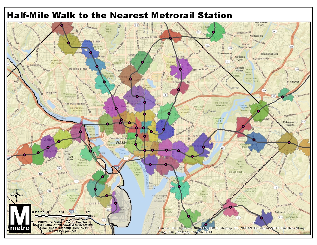
Did you ever wonder which Metrorail station is closest? Where’s the breakeven point between two stations? This map shows the areas you can actually reach within a half-mile walk along the roadway network, as we described previously. The twist this time is that I disallowed “overlap” within the GIS network analysis, so land is allotted to the closest station only, calculated by network walk distance.
What do you see in this map? Here’s a regional view with all stations, as well.
Update 9/2/2014: the GIS source file for this map is now available for download, in geodatabase (.gdb) format.
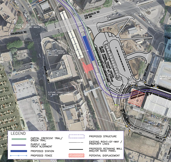
To handle future ridership demand, Silver Spring may need a new mezzanine to connect Metrorail to the planned Purple Line light rail station.
Last year, we began a study looking at potential station capacity issues at Silver Spring. The assessment determined that the demand at the Silver Spring Metrorail station (entries and exits) is adequately served by the existing station infrastructure. Since then, the study has assessed the future conditions that will be impacted both by ridership growth due to growth of jobs and households in the station area, but also the arrival of the Purple Line light rail to Silver Spring.
The Purple Line station at Silver Spring is planned as an elevated platform and mezzanine, with the mezzanine connecting to the top floor of Silver Spring Transit Center, Metropolitan Branch Trail, and Ripley Street to the south. The elevated light rail platform will be approximately 80 feet above the street, about the height of the current MARC pedestrian bridge. The MTA design team envisioned a possible direct connection between Metrorail and the Purple Line, as illustrated in the red shape in the center of the above image. Without such a connection, riders transferring between Metrorail and the Purple Line at Silver Spring would have to descend those 80 feet to the ground level, enter an existing Metrorail mezzanine, and then ascend again to the Red Line platform. Read more…
Recent and upcoming Metrorail service changes to accommodate the Silver Line have been in the works for over a decade, and are better for Blue Line riders than originally planned.
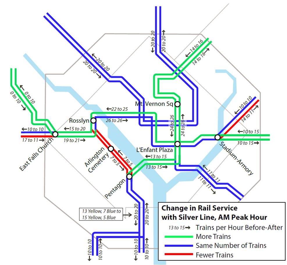
Metrorail Service Changes with the Silver Line Opening on July 26, 2014
Read more…
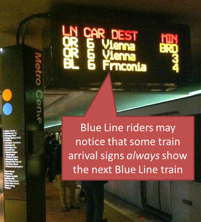
 Some train arrival signs now always show the next Blue Line train, and it’s helping Blue Line riders determine their best route.
At rush times, Blue Line riders know they can sometimes see two or three Yellow or Orange Line trains go by before a Blue Line train arrives. For some riders, knowing just how far away the next Blue Line train is can help them decide: is it worth waiting, or should I get on the next train and transfer at L’Enfant Plaza?
To help Blue Line riders, Metro changed the arrival signs to always show the time until the next Blue Line train arrives, even if it’s more than three trains away. That means that riders can always tell how far away a Blue Line train is, and decide whether to wait for it, or use the Yellow Line instead. Read more…
The region either already has or is planning for a variety of different modes. How do they compare?  The Silver Line will soon open as a Metrorail line. Later this year, a streetcar will be operating on H Street, NE with others planned for Columbia Pike in Arlington and the District. Arlington and Alexandria are jointly building a bus rapid transit (BRT) line between Crystal City and Potomac Yard. Once funding is finalized, Maryland will build the Purple Line and light rail transit (LRT) will connect New Carrollton and Bethesda. This is all in addition to the region’s existing commuter rail, commuter bus, Metrorail, Metrobus, and MetroExtra services. The region is not only expanding transit services, but it also expanding the types of transit modes that will operate. At long last, instead of talking about Portland (streetcar), Jersey City (light rail), or Cleveland (bus rapid transit), we’ll be able to point directly to services and infrastructure in our backyard or take a trip and experience the pros and cons of these modes for ourselves.
So how do the different modes compare? What kind of purposes does each serve? There are many external factors and trade-offs that influence how agencies and jurisdictions select which mode to implement. As we see from the ongoing debates in jurisdictions across the region between LRT and BRT or streetcar and enhanced bus, there is not always one perfect choice. However, an array of transit and land use measures can provide context to the conversation. As part of ConnectGreaterWashington: The 2040 Regional Transit System Plan, we developed the below table to compare commuter rail, commuter bus, heavy rail, light rail, streetcar, bus rapid transit, and enhanced bus across land use intensity (households and employment), vehicle capacity, stop spacing, trip length, and capital and operating costs.
What do you think? Does this information better inform the rail vs bus debate? What other information would provide more clarity on what modes work where?
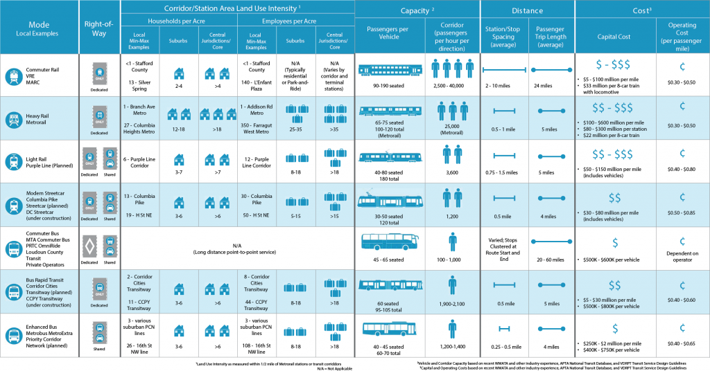
Comparison of High-Capacity Transit Modes


Recent Comments