Posts Tagged ‘bike’

What Does the State of the Commute Survey Tell Us?

January 11th, 2012 1 comment

State of the Commute Survey Results

Last summer, the Metropolitan Washington Council of Governments (MWCOG) posted the results from the 2010 State of the Commute (SOC) Survey. Metro planners are reviewing the results now in support of our Regional Transit System Plan, which is looking to better connect areas of concentrated growth, such as the regional activity centers, and increase core capacity through 2040. The survey is conducted every three years to help MWCOG’s Transportation Planning Board better understand commuting trends and evaluate the effectiveness of its Commuter Connections program, which provides information about and benefits for commuting by transit and carpooling instead of single-occupancy vehicles (SOV).

Read more…

New Bike Racks Rolling Out…

January 5th, 2012 10 comments

In December, Metro installed new bike racks for over 100 additional bicycles at Metro stations, and more are on the way.  We are trying to install racks where demand is high, space is available, and/or where we can fit bike parking under existing overhangs or shelters for weather protection. These actions represent initial steps under “Implementation Strategy 1” in Metro’s Pedestrian and Bicycle Element of 2012-2017 Capital Improvement Program, and have been taken up by Metro’s Plant Maintenance team (PLNT). PLNT has energetically taken on the role of installing these bike racks, which are in addition to their normal duties of grass mowing, snow removal, cleaning and painting, etc.  Their work is a real support to the bicycle and pedestrian program!

So far we’ve installed at Benning Road, Silver Spring, Shaw-Howard U, West Hyattsville, and L’Enfant Plaza, and have scheduled more for January.  We’ve been taking photos along the way:


Categories: Planning Studies Tags: ,

Identifying & Funding Pedestrian and Bicycle Project Needs

December 22nd, 2011 7 comments

Back in August, we posted information about our latest endeavors to improve bike and walk access to Metrorail.  We have since completed our field work and now have a laundry list of more than 3,000 individual projects throughout the Metrorail system that we identified through that effort.  The projects range from the small and simple (e.g., Vienna racks) to the larger and more complex (e.g. additional Bike & Rides).  Metro’s Pedestrian and Bicycle Element of 2012-2017 Capital Improvement Program (1.1 MB, PDF) summarizes the findings by category, and provides an overview of the methodologies we employed to prioritize projects, as we identified a larger need than is currently funded.

And, although the  primary goal of this project is to provide a list of needed bike and pedestrian access projects to be funded through Metro’s Capital Improvement Program (CIP),  the list of needs developed in the inventory also will help better inform our partnerships on transit oriented development (TOD) and other projects near our stations.  Many of the projects improve the links from our station property to that of other property owners and will be instructive as stations undergo development transformations.

Project Highlights

Field teams were out evaluating conditions all over the system.  They highlighted desire lines to stations, bike parking needs, sidewalk & pathway improvements, intersection improvements and other pedestrian and bike needs.  Below are some high level summaries to give you a flavor of what we found out there:

Sidewalks and paths: Our field work identified hundreds of small sidewalk and pathway projects typically on Metro property that will improve access to our stations.  Each project tends to be small, say 200 to 500 feet long, but added together from end to end, they would stretch 10 miles.  Most of these projects are at suburban stations, where our entrances tend not to be directly located on the street network.

Intersection improvements: We looked at the intersections that serve our stations for places where new crosswalks, curb ramps, crossing islands or other improvements were needed and found 700 locations for such improvements.  Many of these are located off of our property on adjoining streets, so we plan to work with the local jurisdictions to address these.

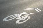
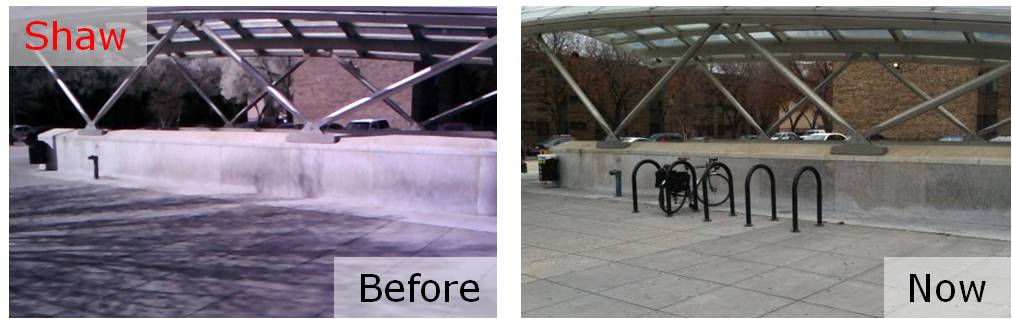
Bike parking: More than 400 potential locations for future bike parking were identified, including the type and expected capacity of parking.  The field survey explored potential locations for additional Bike & Ride parking facilities and covers for bike racks.  Our plan is to build or reserve space for bike parking in the amounts needed to help us reach our mode share goals of 2.1% by 2020 and 3.5% by 2030.  To make these numbers work, we’ll continue to work with our local bike/ped planning partners to improve the on- and off-street connections to our stations so we can fill this bike parking.

Prioritizing Projects

So, 3000+ is a lot of projects.  We’d love to be able to do them all.  However, our funding is currently constrained.  So, what do we do? – we prioritize.  And, how do we do that?  We look to our Agency goals.  At the top of the list is safety & security, delivering quality service and using resources wisely.   We took a look at how our projects stacked up against these goals and created an action plan to complete the projects that best achieved them.  There are more details about the process in the attached document, but let it suffice to say we think we’ll make some real headway in meeting these goals and their accompanying objectives as we improve access to our stations.  In the meantime, if other funding opportunities crop up – say TIGER IV, or V, or XXXII – we’ll be ready to go.

Follow Along with Us

We have already begun work on the projects identified, and planning for more projects is underway.  As we complete projects we’ll continue to post them here.  Please let us know what you think.  Have they helped?  Are there other projects you see out there?

Update January 18, 2012: Maps of all project needs at by individual Metrorail station are available below. Due to the size of the files, we’ve posted them as 8 separate documents in alphabetical order by station name. They should be readable with Adobe Acrobat 6.0 or later:

  1. Addison Road-Seat Pleasant to Capitol South (PDF, 2.2 MB)
  2. Cheverly to Dunn Loring-Merrifield (PDF, 2.2 MB)
  3. Dupont Circle to Gallery Pl-Chinatown (PDF, 2.5 MB)
  4. Georgia Ave-Petworth to King Street (PDF, 6.0 MB)
  5. Landover to Metro Center (PDF, 1.2 MB)
  6. Minnesota Ave to New York Ave-Florida Ave-Gallaudet U (PDF, 7.0 MB)
  7. Pentagon City to Twinbrook (PDF, 3.2 MB)
  8. U St/African-Amer Civil War Memorial/Cardozo to Woodley Park-Zoo/Adams Morgan (PDF, 2.4 MB)


New Bike Racks Installed at Vienna Station

November 21st, 2011 3 comments

Last week, Metro installed 32 new “U-Rack” bicycle racks at Vienna station, providing parking space for 64 additional bicyclists, nearly doubling bike parking capacity.  The new racks are located on the north side of the station, in the direction of the parking garage.  The installation is the latest in Metro’s overall Bicycle and Pedestrian Capital Improvement Program.

New bicycle racks at Vienna Metrorail station, with new space for 64 bikes. The existing racks at Vienna were often full or overflowing.

Read more…

College Park Bike & Ride Under Construction

October 6th, 2011 Comments off

Construction has begun for a Bike & Ride at College Park garage

This week, Metro’s contractor began constructing our first secure bicycle parking facility at the College Park garage.  In the spirit of our “Park & Ride” facilities for vehicles, this facility will be called a “Bike & Ride.”

Temporary fencing is up around the site now while a new concrete slab is poured.  Steel walls are being fabricated and will be installed over the coming weeks, along with new lighting, cameras,  doors, and of course bike racks.  We should be finished with construction this winter – unfortunately just as cold weather begins to discourage many cyclists, but the timing will allow us to work out any kinks before the spring.  As with any pilot project, this will be a learning process for us and you, so bear with us as we work through the logistics. Read more…

Categories: Planning Studies Tags: , ,

The Bicycle and Pedestrian Capital Improvement Program

August 18th, 2011 3 comments

Back in December, we told you about the Metrorail Bicycle and Pedestrian Access Improvements Study, which recommended ways for enhancing bicycle and pedestrian access in and around Metrorail stations.  Since then, Metro has been developing a capital program aimed at implementing some of these recommendations.  Here is an update on our progress and some discussion on what’s next:

Recent Highlights

In February, Metro’s Board of Directors adopted a goal to increase bike mode share from 0.7% to 2.1% by 2020 and 3.5% by 2030.  Around the same time, we made improvements to the bicycle section on Metro’s website.   This spring, we surveyed use and capacity of bike racks at Metrorail stations and conducted an inventory of unmet bike and pedestrian needs at Metrorail stations.
Read more…

Bicycle Parking Census at Metrorail Stations

August 3rd, 2011 1 comment

Bicycle access is a key long-term access strategy to Metro’s services, and we are currently trying to triple the number of bicyclists accessing our network by 2020.  As we develop plans for capital investment in bicycle and pedestrian facilities, we need good data on bicycle parking demand to tailor new facilities to each station.  Our most recent bike parking counts were from 2006-2007, but a lot has happened since then.

So, taking a cue from from trail count data, we counted bikes and racks at rail stations over a six-week window of peak usage from May 1 to June 15 for a “bike parking census.”  Each station was counted on a sunny, warm day typically between 9:30am and 3:00pm. We wanted to learn about the general availability of and demand for bike parking in station areas. For these counts, we specifically excluded bike lockers and the Union Station Bikestation, and focused just on racks. We wanted to know how easy it would be for a new bike-to-rail customer to easily find bike parking near a station.  We counted each U-Rack as space for 2 bikes, and used our best judgment for wave, grid, post-and-ring, and other racks.

Read more…

Categories: Planning Studies Tags: , ,

Help Wanted: Pedestrian/Bicycle Project Manager

August 1st, 2011 Comments off

We are looking for a Project Manager, who will be located in our Office of Parking – which has taken on a broader mantle to include non-auto parking management (i.e., bicycles) – to coordinate bicycle and auto-related parking projects, as well as pedestrian access projects here at Metro.  The project manager will coordinate all aspects of implementation – design and engineering review, environmental review, and construction coordination.  The project manager’s project portfolio will be heavily influenced by the projects identified in the Planning Office’s recent bicycle & pedestrian access needs inventory.  This is a great opportunity to make a solid impact on bike, pedestrian, and transit infrastructure in our region. To see the full job description and apply, please go to our careers website, and see posting 110834.

Applicants will need to register with our on-line system to apply.  The posting is open through August 5.

Balancing Transit Mode of Access with Urban Design in Suburban Settings: A Comparative Assessment of Four European Transit Systems

May 27th, 2011 1 comment

Metro’s early experience with promoting TOD took place at below-ground rail stations in established urban settings that did not require the provision of transit access facilities beyond connections from sidewalks to the stations below. More recently, WMATA’s opportunities to develop its land to support TOD have been predominantly in suburban rail stations that include extensive parking lots, bus bays, and facilities for taxis, bicycles, customer pick-up and drop-off, and ADA patrons.

The default agency policy in recent years has been to replace existing facilities with a like amount and kind of facilities on a reduced footprint, and to emphasize transit operational functionality over urban design issues.  For example, this approach has tended to favor placing parking structures and bus bays adjacent to the station in lieu of pedestrian facilities, public spaces and mixed-use development.  However, public feedback has prompted WMATA to reassess the appropriateness of this default approach, and there is a need for new thinking about how future patrons should arrive at suburban stations; how transit operations should function in TOD contexts; and how to better meet local development policy objectives.

Development plan for Twinbrook Metrorail station.

Development plan for Twinbrook Metrorail station. Click the image for more information.

Over the past five years, WMATA has made a number of significant policy and program changes to recognize the changing development environment at suburban rail stations. For example, in 2008 WMATA adopted a new set of real estate development guidelines (1.91 MB PDF), and the first real estate projects implementing those guidelines were initiated in the summer and fall of 2010. While the evolution of WMATA’s planning and land development practice is underway, it is far from complete. WMATA’s most recently-launched TOD projects confront the agency with the immediate challenge of replacing first-generation, auto-oriented transit access facilities with a new generation of facilities that supports transit access, transit operations, and TOD.

Read more…

Learning About Bicycle Commuters

May 13th, 2011 18 comments

Metro is trying to triple the number of bicyclists accessing our transit services by 2020.  Our Bicycle & Pedestrian Access Improvements Study showed that although bicycling represents a small portion of station access now, this mode has very strong potential for growth.  For example, many of our parking customers live less than 3 miles from their rail station, and many parking facilities fill up between 7:45 and 8:30 am.

Custis Trail in-ground counter

As part of this campaign, we are trying to learn more about the travel patterns of bicyclists so that we can better plan facilities and services for them.  For example, how strong is the “seasonal” effect in biking?  What time of day do cyclists ride?  How does bicycling demand patterns compare to our rail and bus networks?

One source of data for these questions is the automatic bicycle counters that Arlington County has installed on the Custis Trail, a major trail for bicyclists between downtown, Arlington, and points west. This counter can sense the difference between a bicyclist and a pedestrian, and has been silently counting both since October 2009.  The counter is located at the top of the hill between Rosslyn and Courthouse (map).  Previous analyses of this data are available online.

While Custis Trail users certainly don’t necessarily represent current or potential bike-to-rail customers, they do provide some data-driven insight into the travel demand of bicyclists, whom we hope will be a key part to Metro’s long-term strategies for rail access.  So, the rest of this post analyzes bicycle counts by 15-minute intervals between October 2009 and February 2011.

Read more…