Momentum is just one component of Metro’s vision for the future of transit in the Washington region.
We know that there are many questions about the relationship between Momentum, Metro’s strategic plan, and ConnectGreaterWashington, Metro’s long-range Regional Transit System Plan. These are two really ambitious, visionary plans that put forth a vision both for the Authority itself, as well as the transit map of the future. So below is a handy reference guide that compares the two plans across a variety of factors. This FAQ is a work in progress, so please add questions below and we will modify the table with other key details.
|
Momentum
|
ConnectGreater
Washington
|
|

|

|
| Purpose |
- Develop actions that Metro can take to meet the mission, vision and goals adopted by WMATA’s Board.
- Identify key infrastructure initiatives, defined as Metro 2025, that Metro can implement to maximize the existing system without expanding it.
|
- Develop the future transit map that the region needs to meet its projected population and employment growth.
- Note the plan is being developed without specific operators in mind, especially for the high capacity surface transit corridors. However, a subset of the overall plan will come under Metro’s purview, build on Metro 2025, and ultimately become Metro 2040.
Read more… |
This is the second post in a two-part series based  on content from the tenth meeting with the Regional Transit System Plan (RTSP) Technical Advisory Group (TAG) that was held in July. The first post focused on our analysis of new Metrorail lines in the core and Virginia. This post is about our approach to identify regionally significant corridors for high capacity transit.
By 2040, multiple regionally significant travel corridors will need high capacity, high frequency transit to connect people and jobs outside of the core.
As part of the RTSP, we will identify regionally significant corridors where transit priority infrastructure is needed to provide high capacity transit. At the TAG meeting, Metro Planning staff presented a methodology to identify, evaluate, and prioritize these regionally significant corridors. The methodology has evolved since the July meeting and is described below. The actual evaluation and prioritization is still in process.
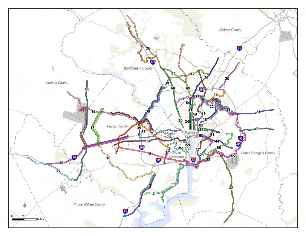
Corridors identified for evaluation for high capacity transit.
Since the TAG meeting, we have also conducted one-on-one meetings with each jurisdiction and agency in the RTSP study area to review and gather feedback on the full set of corridors that will be evaluated. Approximately 70 corridors have been identified from:
Read more…
This is the first post in a two-part series based  on content from the tenth meeting with the Regional Transit System Plan (RTSP) Technical Advisory Group (TAG) that was held in July. This post will focus on our analysis of Metrorail capacity and crowding, while the second post will focus on identifying and prioritizing regionally significant surface transit corridors.
By 2040, ridership and crowding levels on Metrorail indicate the need for a new Blue Line and new Yellow line in the system’s core and a third line in Virginia.
At the time of our last post, we had run an initial round of four scenarios that sought to resolve regional mobility issues. We gathered a lot of information from the results, but realized that we needed to run a second round of scenarios focused almost entirely on Metrorail. Using MWCOG’s Cooperative Forecast Round 8.1 land use, which has been adopted by the region, and MWCOG’s Aspirations land use, which shifts more jobs and households into the regional activity centers, the maps below clearly demonstrate crowded conditions in 2040. The Base Network shown in these maps includes 100 percent eight-car trains and all the CLRP projects. Crowded conditions exist on the Orange Line west of Rosslyn, on the Yellow and Green Lines south of L’Enfant Plaza, and on the Silver Line west of Tysons. Because the results indicated that Metro would be severely crowded EVEN if we run the longest possible trains (eight-car trains), we wanted to explore other long-term solutions.
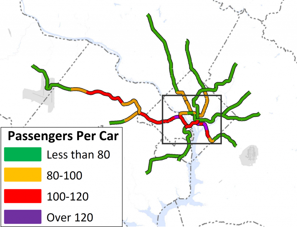
Crowding on Metrorail by 2040, even with the longest possible (eight-car) trains. Base Network AM Peak, Round 8.1 Cooperative Forecast
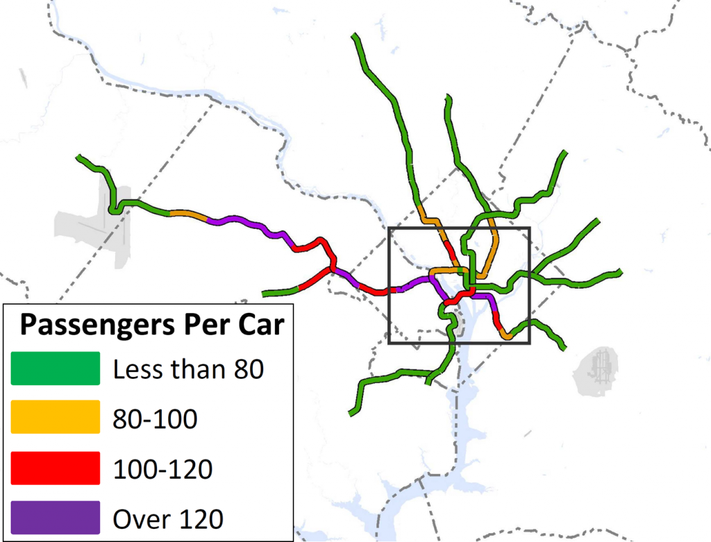
Crowding on Metrorail in 2040 even with the longest possible (eight-car) trains, Base Network AM Peak, Aspirations Land Use
Read more…
The year 2040 may seem distant  and removed, but in the context of transit planning, it is right around the corner. Metro’s Office of Planning is in the process of developing the 2040 Regional Transit System Plan (RTSP), which will outline a comprehensive regional transit network to prepare the region’s transit system for continued growth.
The RTSP, along with other elements that may be identified in the future, will need to be evaluated as necessary to meet the demands in the future. The plan includes a combination of core system improvements, which are included as part of Metro 2025 above, as well as system connectivity and expansion projects. Most importantly, it combines all modes in the region’s transit system, whether or not Metro will build or operate them. The strategies in the plan are designed to both serve existing areas better and provide service to new areas, helping to realize Region Forward’s vision of regional activity centers with transit options that improve regional mobility, enhance commerce and competitiveness, and have environmental and health benefits for generations to come.
Read more…
Momentum builds upon and advances  a number of regionally significant planning studies that are either recently completed – or underway. They include:
- Region Forward: A vision for the DC region created by the MWCOG. It addresses the interrelated challenges of population growth, aging infrastructure, traffic congestion, energy costs, environmental impacts, affordable housing and sustainable development, as well as disparities in education, economics and health (2010)
- Economy Forward: A companion piece to Region Forward that reinforces the importance of transit to the region’s overall competitiveness (2012)
- Financially Constrained Long-Range Transportation Plan (CLRP): The region’s official long-range transportation plan that outlines the priority projects to be implemented in the region between 2012 and 2040 as prioritized by the Transportation Planning Board (TPB) and local jurisdictions (2012)
Read more…
Since 2010, the Board of Directors 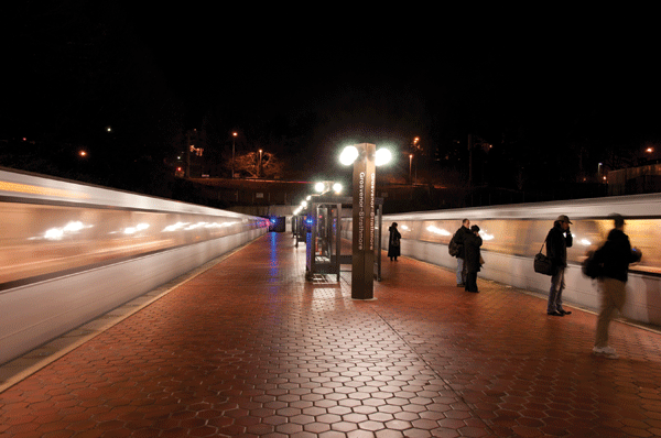 has been laying the foundation to rebuild Metro itself. From hiring a new General Manager to beginning the largest capital program since the inception of Metro, the Board has taken numerous actions to better equip the agency to succeed, including providing a stronger governance foundation.
Under the leadership of the Board, Metro has made substantial progress on improving system safety, reforming the agency’s governance, and stabilizing its finances
The Board has made strategic investments in infrastructure, equipment and workforce training, and developed policies that have markedly improved safety, as recognized by the NTSB and FTA and documented in the Authority’s publicly-reported Vital Signs score card.
Governance reforms undertaken over the last two years have modernized Board leadership, strengthened the Authority’s governing structure, improved the Board’s partnership with the General Manager/Chief Executive Officer, enhanced internal management, and prioritized public dialogue. The Board also adopted governance reform measures that strengthened its Code of Ethics and provided its first-ever bylaws, which detail the Board’s focus on policy, financial direction, oversight and Metro’s relationship with its customers and jurisdictional partners.
Read more…
The National Capital Region Transportation Planning Board (TPB), the region’s Metropolitan Planning Organization (MPO), adopts the region’s constrained long-range plan (CLRP) annually. Only projects included in this regional transportation plan are eligible for federal funding, and since 1991, federal law requires the CLRP to be constrained financially. This regional transportation plan includes only projects that are reasonably expected to be fully funded.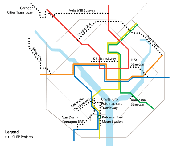
Read more…
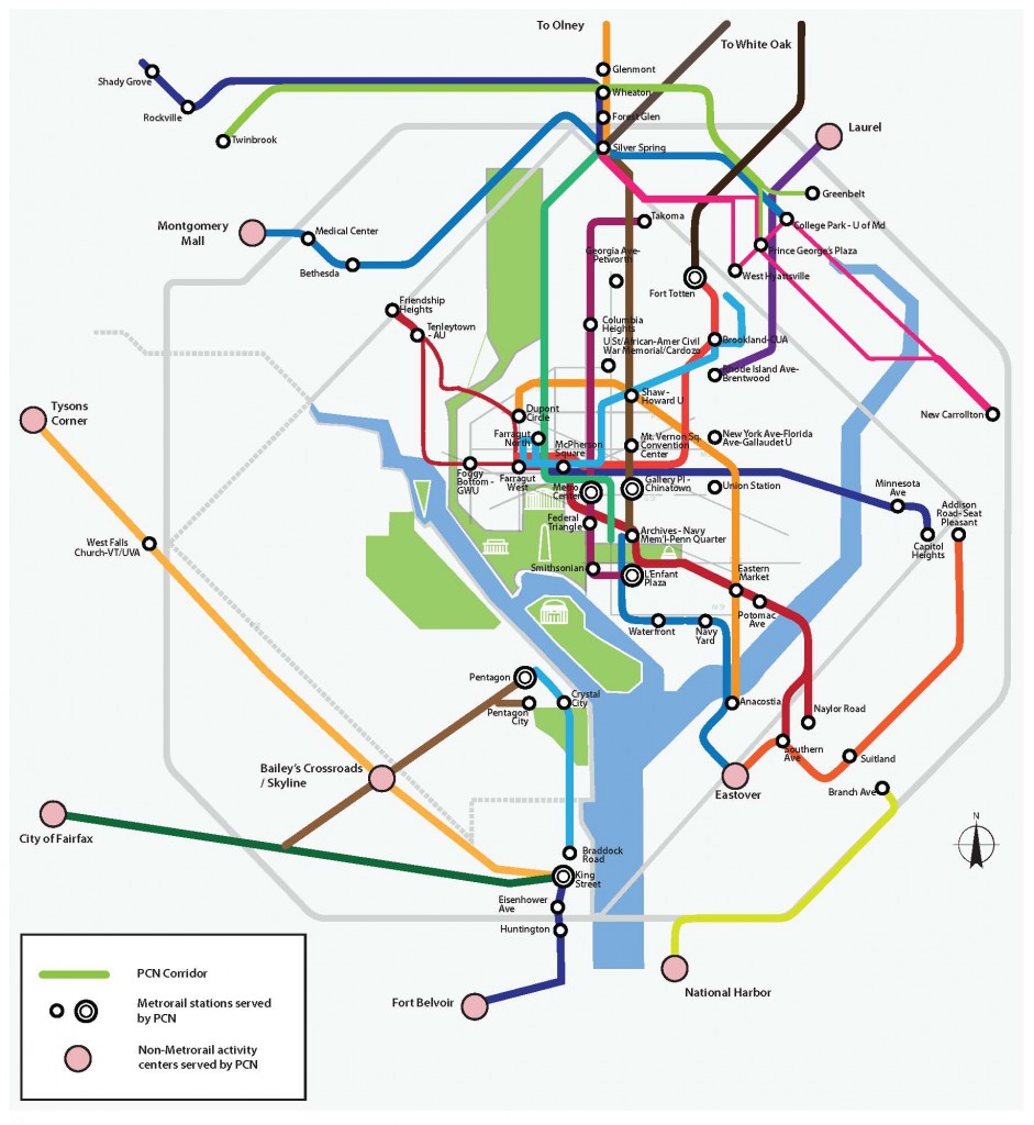
Metrobus’ Priority Corridor Network (PCN) Plan will improve bus service, travel speeds, and reliability on 24 regional corridors, which serve half of Metrobus ridership. Improvements include:
- Improved operational strategies such as transit signal priority and exclusive bus lanes
- Increased frequency and span of service
- Improved customer information
- Added MetroExtra, Metro’s limited-stop bus service, routes and buses
- Expanded fare payment options
- Added safety, security and incident response measures
- Enhanced bus stops and facilities
 Read more…
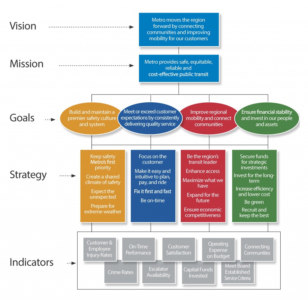
The strategic plan for Metro supports the vision of tomorrow’s transit ride and gives guidance to the types of investments and decisions that Metro can and must make in order to achieve this vision and support the region. The strategies flow directly from Metro’s Board-endorsed vision, mission, and goal statements, and provide the overarching framework for executing the General Manager’s business plan.
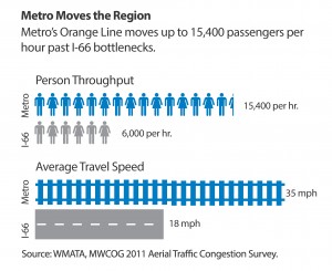
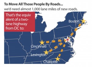
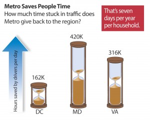 Metro does far more for the region than simply providing transportation. It also provides economic, social, and environmental benefits which contribute to the region’s health and vitality.
Making the Case for Transit (2011) found that without Metro and the regional transit system that it feeds:
- There would be one million more auto trips per day;
- Congestion would increase by 25 percent;
- All Potomac River crossings would need four to six additional lanes; and
- Downtown Washington would require 200,000 more parking spaces, which is the equivalent of 166 blocks of five-story garages, at a cost of at least $4 billion (2012), excluding land.
Read more…


Recent Comments