‘Planning Studies’

Metrobus Fuel Efficiency on the Rise

September 27th, 2012 8 comments

In recent years, the fuel efficiency of the Metrobus fleet has significantly improved, reducing Metro’s fuel expenses, and improving Metro’s environmental sustainability.

Metro’s bus fuel efficiency has increased by 27% over the past eight years, reducing fuel costs and improving environmental sustainability.

Over the past 8 years, the average fuel economy of Metro’s bus fleet has increased by 27%, from 2.96 miles per gallon (MPG) to 3.76 MPG today. The chart at right illustrates this trend, using actual odometer and fuel readings which are gathered and stored by our bus technology group.(Note that these figures include the consumption of compressed natural gas [CNG], expressed as gallon-equivalents. The slight dip in FY2011 is the result of some data loss during a transition to an electronic mileage tracking system.)

What is Causing this Trend? This steady increase in fuel economy is generally the result of technological improvements in the fleet.  Metro has been replacing older standard diesel buses with newer diesel-electric hybrid, CNG, and clean diesel models.  In particular, introducing diesel-electric hybrid buses to the fleet has helped push up the average: on the streets today, our diesel-electric hybrid fleets are achieving average mileage of 4.49 MPG.  Metro purchased its first hybrid bus fleet in 2006, and today these buses provide 41% of Metro’s bus vehicle-miles.commercial jumping castle for sale

Read more…

Metrobus System Map Redesign

September 19th, 2012 86 comments

Ask anyone in the transit industry, from any country or any city, and they’ll be quick to tell you that WMATA’s bus system is one of the most complex in the world.  So many lines, so many routes, so many variations, so many streets, so many buses!  It really all speaks to the great lengths that Metro takes to ensure premium bus service is provided to its many customers spanning a vast service area. As you might expect, if such a system has been coined complex by transit industry “experts,” then surely the system would be thought complex by the average bus customer.  Therein lies the challenge:how do you take this complex, complicated, extensive bus network and relay it to customers in a clear, simple, yet fairly detailed manner?  Well, there’s not just one answer to that question.  But, one of the main tools Metro uses to inform bus customers of their travel options is the Metrobus System Route Map.

The current pair of System Route Maps, DC/MD (PDFs) and DC/VA (PDF), display the travel patterns for each Metrobus route in each jurisdiction (MD, DC, VA). In short, they answer the question, “How can I get there on the bus?”  These geographically detailed maps chart out the complex routes Metrobus travels, leading customers from the origin to the destination of their trip, calling out street names, shared routes, schools and points of interest along the way.

Subset of the previous DC Metrobus map showing northeast DC

While these maps have served their purpose over the years in acclimating customers to Metro’s bus network, there is room for improvement.  For instance, while the current system maps display all the bus service for Metro, there is no consideration given to frequency of service, i.e. how often a bus runs.  This could cause problems in that while the map might show that a bus route services a particular area, it does not relay information that the bus might only service that area during the a.m. rush or on the weekend.  In addition, while the maps are geographically detailed, this detail comes at a high price; cluttering the map with many lines in many directions that make it difficult for customers to follow along and actually trace the pattern of the route they need.

These and other deficiencies in the current system map have been the impetus for WMATA looking into different ways to illustrate our bus service.  In November of 2010, Metro’s Office of Long Range Planning released a draft “Metrobus High-Frequency Corridors Map” on this site, to gather feedback on how we might better explain our complicated bus system to users.  The feedback received was incorporated into additional planning work on a Metrobus map design.

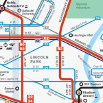
Following extensive design work, Metro is pleased to announce revised draft system maps that more clearly depict bus routes and delineate frequency of service, all part of our ever evolving efforts to provide richer and clearer travel information to our customers.  Click the links below to view samples of the new maps. Feel free to give us your feedback, and note that these maps will be revised based on feedback from customers.


Subset of new draft DC Metrobus map showing northeast DC.


Below, you will find some key features of the system map redesign: Read more…

Categories: Planning Studies Tags: ,

Developing Metrorail Service Standards

September 5th, 2012 16 comments

Just as Metro has standards guiding major policy decisions for its bus services, we are now taking the first steps in establishing a similar framework for its rail service. Service standards are important to define service quality and quantity as well as future capital investment needs, such as increasing core capacity and adding more service. As with any standard, there are constraints. Physical constraints include equipment, system capacity and tunnel throughput. In addition to physical limitations, there are budget constraints for staff, to make system investments or to purchase more rail cars. To begin the formalization of service standards, Metro is starting with three, simple key standards:hours of service, rush hour headway and rush hour capacity. Establishing the foundation for rail service standards now will allow us to add more quality standards in the future. Additionally, these service standards will provide a base for further discussions to come in Board’s strategic planning effort. To ensure we’re heading in the right direction, we’d like your input. Watch this video and then please provide your comments.

Brookland Pedestrian Improvements

August 31st, 2012 3 comments

Metro has constructed several pedestrian improvements on the east side of Brookland-CUA station to create a safer and more pleasant pedestrian experience.The majority of the work was improving the connection from the station entrance to Bunker Hill Rd. NE  (map), which had previously been a dirt path.  We installed new stairs and an accessible ramp to Bunker Hill Rd. NE, and added sidewalks and curb ramps along the road, up to the intersection with 9th St. NE.  In addition, we made improvements to several crosswalks and curb ramps near the bus loop. We undertook this work as part of Metro’s Pedestrian and Bicycle Element of 2012-2017 Capital Improvement Program.  Pictures below:

New staircase and ramp replace former dirt path at Brookland-CUA station

New sidewalk and curb ramps replace former dirt path

New sidewalk to access intersection of Bunker Hill Rd. NE and 9th St. NE

As some eagle-eyed spotters have noticed, we are also working on installing new bike racks on the west side of Brookland-CUA station, near the Met Branch Trail. However, the installed racks were not quite up to our standard, so we have instructed our contractor to replace them and they should be complete shortly.

Categories: Planning Studies Tags: ,

DC’s H and I Streets NW Bus Lane Study

August 3rd, 2012 5 comments

Metrobuses in congested traffic on Eye Street NW during the PM Peak

The Washington, D.C. region continuously ranks as one of the most congested metropolitan areas in the nation.  Metrobus plays an important role in connecting residents to activity centers and alleviating traffic on arterials.  However since Metrobus vehicles operate within mixed traffic, Metrobus service experiences delays and reduced travel speed on a daily basis.

To improve the effectiveness and reliability of bus service, WMATA and DDOT recently initiated an operational analysis to explore bus-only lanes along  H and I Streets NW, one of the busiest bus corridors in downtown Washington, DC.  The study team recently completed the existing corridor conditions assessment and applied VisSim, a multi-modal traffic simulation tool, to identify and quantify the congestion impacts on buses as well as other roadway users, including pedestrians, bicyclists and private vehicles.

Read more…

2012 Bicycle Parking Census at Metrorail Stations

August 2nd, 2012 8 comments

In May and June, Metro staff traveled the region counting parked bicycles at all Metrorail stations. These bike counts help measure our progress in attracting bike-to-rail customers, and are a key piece of data when we plan for bicycle facilities in the future as part of Metro’s Pedestrian and Bicycle Element of 2012-2017 Capital Improvement Program. Here are some results.

Similar to last year’s counts, the objective of the census was to measure the general availability of, and demand for, bike parking around Metrorail stations. Regardless of who owns the racks, we want to know how easy it would be for a passenger to find a place to park a bike near a station at peak times.  So, we counted during a six-week window on sunny, warm days from May 1 to June 15, between 9:30am and 3:00pm.

We excluded bike lockers, the Union Station Bikestation, and the College Park Bike & Ride (we counted the racks at that station shortly before that facility opened).  We counted each U-Rack as space for two bikes, and used our best judgment for other racks.

Download the count data for yourself (.xls)

Read more…

Categories: Planning Studies Tags: ,

Metrorail Parking Pay-by-Phone Pilot

July 26th, 2012 2 comments

A familiar sight at Metro’s metered lots is that of a customer searching for coins to feed the parking meter.  Priced at $1/hour, that can add up to a lot of quarters or dollar coins.  Starting Monday, July 30, 2012, at the Fort Totten and Rockville Metrorail stations, Metro is introducing a new parking meter technology from  Parkmobile that will allow customers to pay for parking using a smartphone app or over the phone. It’s the same payment system widely in use in the District of Columbia, but with an extra twist: within seconds, thanks to sensing technology from Streetline, the time you pay actually displays on the meter.  You can find out about Parkmobile and download the app at  http://parkmobile.com.


This new Parkmobile payment technology is compatible with the “Parker” app by Streetline for iPhones and Android, which provides another option for cash-free payments while enabling many additional features.  For example,  you can find a parking spot in real time at the Fort Totten and Rockville metered lots, and the Vienna-Fairfax/GMU South daily surface parking lot.  Additionally, Parker provides policy information for every single Metro parking lot and garage (even those without sensor information) — see http://www.streetline.com/find-parking/.

Read more…

Categories: Planning Studies Tags: ,

New Pedestrian Paths at College Park Station

June 6th, 2012 3 comments

In conjunction with the Bike & Ride facility, Metro recently constructed multiple sidewalks on the east side of College Park – U of MD station to provide easier and safer pedestrian and bicycle access to the station and the Bike & Ride.  One of the sidewalks provides direct access to Paint Branch Parkway which leads to the Northeast Branch Trail less than ½ mile away.  In addition to the sidewalks, we installed curb ramps to meet ADA standards, and established a safer pedestrian route across the bus loop to the station entrance.

We undertook this work as part of Metro’s Pedestrian and Bicycle Element of 2012-2017 Capital Improvement Program.  We will be making bike, pedestrian, ADA and sidewalk improvements next at Cheverly, Landover, New Carrollton, Glenmont, Shady Grove, Brookland-CUA, Huntington, W. Falls Church, Vienna and Van Dorn.  What key bike and pedestrian connections at stations do you recommend be made?

Before and after pictures are shown below:

New pedestrian and bicycle improvements at College Park station.


Grand Opening: College Park Bike & Ride

May 14th, 2012 3 comments

Metro will hold the grand opening event to launch its first “Bike & Ride” tomorrow – Tuesday, May 15 at 10:00am at the College Park-U of MD Metrorail station.  You are invited to join us that morning, where you can hear a few words from some elected officials and Metro leaders, take a few photos, and tour the facility.

Ready to get started? Sign up now for a $20 BikeLink card, read the brochure, and you’re on your way to secure bike parking.

Already tried out the facility? This first Bike & Ride is a pilot project to try a new kind of bike parking, so let us know what you think!  With the facility, Metro hopes to attract more bike commuters to rail by offering customers convenient, flexible, and secure bike parking.  Metro’s Parking Office will operate the facility, with help from BikeLink.  Metro hopes to learn from the design and continue to expand commuters’ access options as part of the Pedestrian and Bicycle Element of the Capital Investment Program. So, let BikeLink and us know what you think of the facility!

2012 Metrorail Survey is Underway

April 20th, 2012 7 comments

As you may have heard, the 2012 Metrorail survey is underway.  There has been quite a bit of discussion online about the survey, so we thought the survey team would use this opportunity to better explain the purposes of the survey

The primary purpose of the survey is to gather data to support operating and planning activities.  Metro reports ridership coming from each of the eight jurisdictions in the Metro service area, and the survey provides the most scientific approach to estimate ridership by jurisdiction.   In some areas, this is a bit complicated as many residences are technically located in a jurisdiction that is different than that listed on their mailing address, and zip codes don’t provide any help there either.  The survey results are “geocoded” using street address and zip code to determine the survey respondent’s jurisdiction of residence.

Additionally, we are asking about transit subsidies received by our riders.   The 2012 survey differentiates between fully subsidized and partially subsidized riders, expanding our understanding of how our riders make decisions related to fares.  And the survey asks if and where riders are transferring within the Metrorail system.  With the survey data we can develop a clear picture of true transfer volumes at key stations.  This information will help us better plan for future capacity enhancements at transfer stations, including Gallery Place and L’Enfant Plaza.

Below is a list of questions we’ve been asked, and our concise answers.  Below the FAQ are some results from the 2007 Metrorail Passenger Survey.  Feel free to ask any additional questions that we’ve missed in the comments section below and we will try to respond as best we can.

Read more…

Categories: Planning Studies Tags: