Veirs Mill Road BRT Study Underway
While Montgomery County’s Bus Rapid Transit (BRT) plan moves forward through the master plan update process, the county has prioritized some of these corridors for more detailed study. One of these is the Veirs Mill Road corridor, generally stretching between the Rockville and Wheaton Metrorail Stations. Managing the effort on behalf of the county is the Maryland Department of Transportation (MDOT) through the State Highway Administration (SHA) and the Maryland Transit Administration (MTA). SHA, MTA, and Montgomery County hosted an open house in May to introduce the study to local residents and solicit feedback on some of the issues present along the corridor. You can view the study’s webpage for more information, where you can access the May 2012 Open House material.
Strategic Importance
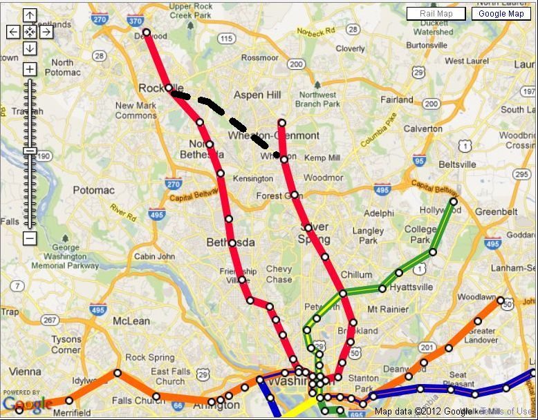
Why is the county advancing the study of this corridor? One reason is apparent with a quick look at the area’s geography and relationship to major transportation corridors.
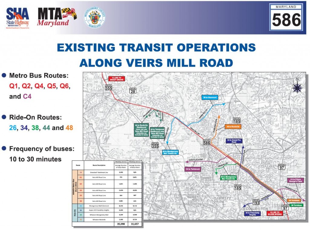
As you can see, Veirs Mill Road (otherwise known as Maryland State Highway 586) is one of the primary east-west corridors connecting Rockville Pike and Georgia Avenue as well as both branches (Shady Grove and Glenmont) of the heavily traveled Metrorail Red Line outside the Washington Beltway. Beyond simply moving cars, the corridor carries thousands of transit passengers each day on both Metro and Ride On buses in addition to bicyclists, pedestrians, goods delivery trucks, and commercial or emergency service vehicles. In fact, Metro’s Q-Line, which frequently traverses the Veirs Mill Road corridor, regularly ranks among the busiest Metrobus corridors in Maryland. The Viers Mill Road Line (Q1, Q2, Q4, Q5, Q6) is a part of Metro’s Priority Corridor Network and was included in the region’s successful TIGER Grant application, which will fund several corridor improvements. The figure below shows the family of transit services which combine to serve the Veirs Mill corridor:
The corridor is also growing in importance to the county’s future mobility because it directly connects two of the the region’s major activity centers, Rockville Town Center and the growing Wheaton Central Business District. Given the county’s emphasis on focusing future growth along transit corridors and trends showing increasing market interest in locating homes and businesses in walkable urban neighborhoods near frequent transit, the case for making improvements becomes more clear. The corridor is also included in the region’s fiscally constrained long range transportation plan, which includes all major transportation projects that have identified financing and are expected to be completed by 2040.
Key Issue: Allocation of Road Space
Although Montgomery County is financing the study and there are many stakeholders (of which Metro is one), SHA’s role is particularly important. As the owner of the roadway, SHA must consider the various users of its facilities and balance the needs of pedestrians, bicyclists, transit passengers, goods and services vehicle operators, and motorists. One of the most challenging aspects of implementing bus rapid transit projects in urban areas is deciding how to allocate scarce road space among the various modes and users. Unlike heavy rail technology such as Metrorail, which must be completely separated from traffic conflicts due to its third rail power supply, BRT is more flexible and can share roadway space with cars and other modes. This flexibility often allows BRT projects to reduce capital costs, but this can come with its own price. The ability to operate frequent, fast service in a separate, exclusive transit guideway is an important feature of a premium, high capacity transit service such as BRT, particularly in corridors with higher transit demand and heavy traffic congestion. Some BRT projects are able to build new exclusive transit lanes in available road space such a median, while in many cases the challenge in planning to build new lanes or convert existing travel lanes to transit use proves too difficult and buses must share lanes with cars in traffic. When buses are caught in traffic, reliability suffers and speeds are reduced, which increases operating costs and lessens the appeal of the transit service to potential customers. This is one of the fundamental challenges of planning and operating transit in busy, congested metropolitan areas.
The Veirs Mill Road features a central median throughout its length, plus service roads and bus/turn lanes along portions of the corridor. There are adjacent businesses and neighborhoods, and natural systems to consider. Will new BRT lanes fit within the right-of-way or can the right-of-way be expanded in a few places without too many impacts? Could reversible one-way BRT-only lanes, operating in the peak direction offer a cost effective solution? How will Metrobus and Ride On buses operate in concert with the new BRT vehicles? How much will the alternatives cost? These are all questions that the study will need to consider and attempt to resolve.
Metro’s Role
While SHA & MTA lead the project development process for the county, Metro has a seat at the table. A few of Metro’s key roles on this project include:
- Providing technical support to the study team, including incorporating information gleaned from the Metrobus Q-Line Study completed in 2009
- Working to identify ways to integrate the BRT project at the Rockville and Wheaton Metrorail stations, two key transfer points for future BRT riders
- Providing input into the planning of how BRT operations with be integrated with Metrobus services along the corridor
Next Steps
The study team is currently working on finalizing the project’s purpose and need, and plans to hold additional community outreach on possible alternatives in early 2013. The project schedule anticipates completing the environmental review by 2014, at which point the project could move into final engineering and construction. Stay tuned to the project’s website, and PlanItMetro for more details on ways you can be involved.


Recent Comments