Posts Tagged ‘Silver Line’

Fans Take Metro Home From Soccer Game

August 13th, 2014 12 comments

Over 7,000 customers took Metro home from the soccer game at Fedex Field on Tuesday night, July 29th, and some used the Silver Line!

While researching the ridership patterns of customers using Silver Line and comparing the usage on Monday, July 28th, to Tuesday, July 29th, we started to see an interesting pattern:  a lot more customers were traveling from Morgan Blvd to Wiehle-Reston East.  When we drilled down into the data, we found that these trips were occurring in the evening, well past the end of the PM Peak.  A few web searches later we discovered that a well attended soccer game had been held at FedEx Field on that night.

We then wanted to know, how many and where did they travel?  The chart below compares entries at Morgan Blvd on the 29th and contrasts it against the entries of the previous Tuesday, July 22nd.  It is pretty obvious that except for the soccer game, it was a pretty normal day at Morgan Blvd, good for comparison.  This data tells us that around 7,500 customers took Metro home from the game.  But where did they go?

The chart below shows the stations that our Morgan Blvd customers used to exit the system after the game.  There are a lot of unreadable data points on there, true, but a few really stand out, as annotated.  Most of the big spikes are end-of-line stations, including our newest, Wiehle-Reston East.  This graph also tells us that customers traveling to Wiehle-Reston East made it to their home station faster than those going to Franconia-Springfield.  In total, over 500 customers took the Silver Line home to one of the five new stations after the game.

This chart also raises the question, why were so many soccer fans going to Eastern Market, Metro Center, Foggy Bottom and Pentagon City?  Those are the earlier spikes shown on the graph.   Perhaps those are the neighborhoods where high densities of soccer fans live, or maybe the locations of good sports bars for post-game refreshment.

Did you attend the soccer game and take Metro afterwards?  Where did you go and what was your trip purpose?


Ballston and the Silver Line: A Big Opportunity

July 30th, 2014 Comments off

This is a guest from Paul Mackie, communications director at Mobility Lab.

A new short video by Mobility Lab details the economic benefits that Ballston stands to reap from this week’s opening of Metro’s Silver Line.

In the video, Ballston Business Improvement District CEO Tina Leone says, “We see the Silver Line as making Ballston the center of the universe. It makes everything even better here. We already have a very active Metro stop, with 26,000 trips per day. We see that growing to 38,000 trips per day along with the Silver Line by 2020. So that’s coming very, very fast.” Read more…

Silver and Blue Line Changes: Over a Decade in the Making

June 30th, 2014 6 comments

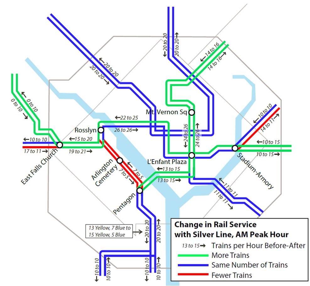
Recent and upcoming Metrorail service changes to accommodate the Silver Line have been in the works for over a decade, and are better for Blue Line riders than originally planned.

Metrorail Service Changes with the Silver Line Opening on July 26, 2014

Read more…

Bus Options for Blue Line Riders

June 24th, 2014 12 comments

“If I’m a Blue Line rider in Virginia, what are my bus options once the Silver Line opens?”

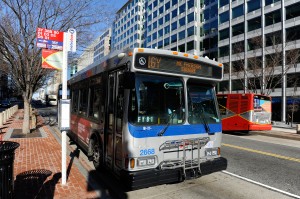
16Y to McPherson Sq.

The 16Y to McPherson Sq.

We get asked this question quite a bit, and even more so now that the opening of the Silver Line is rapidly approaching.  As we have written about extensively on PlanItMetro, the start of service on the Silver Line will mean a reduction in the frequency of rush hour Blue Line trains.  Average headways will increase from 8.5 minutes to 12 minutes.  For most riders, once they arrive at a Blue Line platform their quickest ride will still be via train (even with an additional few minute wait), but there are numerous options for riders looking to switch from rail to bus or new riders looking to commute via bus.

Here are some of your best bus options if you are a Blue Line rider going to, or coming from:

Downtown DC

  • 7Y: Southern Towers to downtown DC.  Beginning August 24, the 7Y will be rerouted to pass within walking distance of these Blue Line stations:
    • Pentagon
    • Arlington Cemetery
    • Pentagon City (2 blocks)
    • Crystal City (2 blocks)
    • Farragut West
    • McPherson Square Read more…

Major changes are coming to Metrobus routes 23A and 23C on March 30

March 25th, 2014 Comments off

On Sunday, March 30, 2014, Metro will improve bus service in the Tysons-McLean-Crystal City corridor. The changes, which will affect Metrobus routes 23A and 23C, were part of a series of improvements presented at our public hearings in the fall of 2013 and will provide significantly improved bus service for the majority of riders on these routes.  This restructuring will also allow better coordination between Metrobus, Metrorail and Fairfax Connector bus service once Silver Line service begins.

What these changes mean for you:

Route 23A riders: 
Route 23A will operate between Crystal City and Tysons Corner Center weekdays during non-peak periods and at all times on weekends. During weekday peak periods, new routes 23B and 23T will replace Route 23A service. New Route 23W will replace all service between Tysons Corner Center and Tysons-Westpark Transit Station.

Route 23C riders:
Routes 23B and 23T will replace all 23C service between the intersection of Old Dominion Drive and Chain Bridge Road in McLean and Crystal City. Route 23C service will be discontinued. Alternate service in the McLean and Langley areas is provided by Metrobus Routes 15K and 15L on Chain Bridge Road and Dolley Madison Boulevard. Read more…

What Metro 2025 Means to Virginia

March 20th, 2014 1 comment

Metro 2025 would bring significant benefits to northern Virginia, allowing the region to thrive economically while preserving regional vitality.

Think Metro’s Momentum plan is all about “downtown?” Think again! Our seven Metro 2025 initiatives – from eight-car trains to bus-only lanes will bring dramatic improvements to the quality of life and transportation to northern Virginia.


Benefits Icons_Expansion

Supports Virginia Transit Projects

Virginia is planning big for transit, which is great – but all of the planned projects rely on a robust Metrorail and Metrobus “backbone” to succeed:

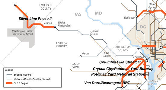
  • The Silver Line extends Metrorail by over 20 miles, and will generate tens of thousands of new riders per day when Phase II opens – many of whom will travel into Metrorail’s already congested core.
  • The Columbia Pike Streetcar will transfer 32,000 riders per day to and from Metrorail at Pentagon City – at a point in the system that is already maxxed out.
  • Two other planned busways (Crystal City/Potomac Yard, and Van Dorn/Beauregard) also connect with Metrorail stations.

All major transit projects funded in the CLRP in Northern Virginia depend on the "backbone" of Metrorail and Metrobus.

All major transit projects funded in the CLRP in Northern Virginia depend on the “backbone” of Metrorail and Metrobus.

By ensuring that Metro services can keep pace with congestion and demand, Metro 2025 is critical to making Virginia’s transit projects a success, and critical to helping the region and the state reach its transportation goals. Read more…

Silver Line Already Spurring Massive Development

January 16th, 2014 Comments off

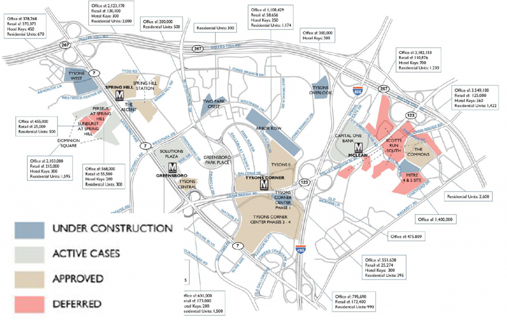
In anticipation of the Silver Line, nearly twenty development projects, with an estimated value of more than $18 billion, are underway near the Metrorail stations,  helping attract riders and generating valuable benefits for Fairfax County.

Anticipating the Silver Line, 20 development projects are underway around the new stations

Ahead of the Silver Line, many development projects are underway around the new stations. Image from Cushman and Wakefield, click link at left for full report.

In a new report, the real estate firm Cushman & Wakefield documented twenty real estate development projects “in the pipeline” near the five new Silver Line stations. Some are under construction now, others are in the approvals process, and a few are on hold, but together they total:

  • Over 20 million sq. ft. of new office space, which would increase the total office space in the Tysons area by 40%.
  • Over 2 million sq. ft. of new retail space. That’s more than twice the size of the Tysons Galleria mall.
  • 17,800 new residential units, or more than double the current population of the Tysons area.
  • 9,300 hotel rooms

Metro estimates that these projects are valued at more than $18 billion, and will generate millions per year in tax revenue for Fairfax County (estimated using industry-standard construction costs). Some of this tax revenue will be captured by special tax districts in the Tysons and Silver Line areas.  In 2011, we estimated that Fairfax County received around $30 million in tax revenues from properties within a half-mile of its five existing non-Silver stations.

The development brings great benefits to Fairfax County and will encourage riders to use the Silver Line, but there remains a strong need to improve the walking and biking environment near the new stations. Pedestrian and bicycle access will be key to meeting our ridership goals for the new Metrorail line, but walking and bicycling conditions remain challenging in the area.


Categories: In The News Tags: , ,

How Will The Silver Line Impact The Region’s Traffic Hotspots?

November 19th, 2013 3 comments

The Silver Line will relieve traffic congestion on the Dulles Toll Road and I-66 when it opens in 2014.

This post is a continuation of our series that answers questions about the new Silver Line.

It’s no secret that the Washington region has some of the worst traffic in the country.  Listeners to “drive time” radio are bombarded with rapid-fire traffic reports noting congestion on major regional highways, often caused by “nothing but volume”.  This expression means there is no traffic accident, weather incident or excessive sunshine slowing cars down.   Instead, too many cars are trying to squeeze into too few lanes at critical interchanges, resulting in traffic queues that can extend for miles and miles.

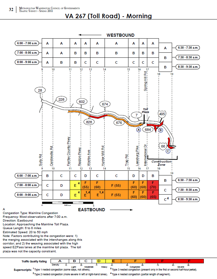
Not surprisingly, the highways along the Silver Line corridor are some of the region’s most congested. The merging of I-66 and the Dulles Toll Road was ranked fourth worst congested location (PDF) in the MWCOG Spring 2011 Traffic Survey.  The survey showed the toll road has three major congestion spots in the AM Peak:  the toll plaza, the interchange with the Capital Beltway and the merger with I-66.  In all three cases, the recurring congestion was caused by vehicles weaving and merging.

Surveyed morning traffic conditions on the Dulles Toll Road, from the MWCOG 2011 Traffic Survey. Image links to PDF report.

According to the MWCOG report, the speed in the traffic queue is between 20 and 50 MPH.  This would result in between 2 and 12 minutes of delay per vehicle joining the back of the queue heading to the toll plaza. Assuming a duration of 2 hours for the queue, average vehicle occupancy of 1.1 and 1,900 vehicles per lane per mile, this results in between 560 and 3,300 person-hours of delay per day, up to 840,000 person hours per year. Read more…

What Will the Travel Times Be on the Silver Line?

September 20th, 2013 26 comments

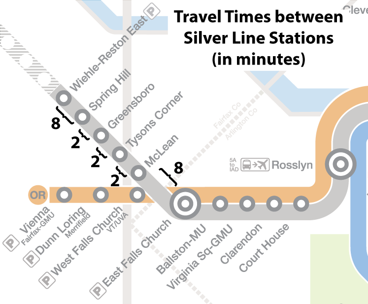
The stations on the new Silver Line are two minutes apart in the Tysons area, and the Tysons-area stations are eight minutes away from both East Falls Church and Wiehle-Reston East.

Silver-Line-Travel-Times

Draft travel times for the new Silver Line stations.

Earlier this year we published a series of posts about the region’s newest rail line, the Silver Line, due to begin service in early 2014. Those posts included answering the questions, “Where will it go?“, “What will happen to rail schedules?“, and “What will happen to bus schedules?“.

Now it’s time to talk about preliminary travel times between Silver Line stations. The map above illustrates the estimated travel times between the five new stations. These times are preliminary and may be refined after operational testing has been completed.

Below is a widget that can be used to look up the travel times between any two stations, including the five new Silver Line stations.*

Read more…

Metro Unveils Final Silver Line Map

September 12th, 2013 24 comments

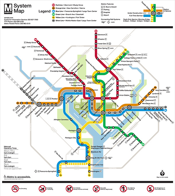
Metro is pleased to release the update to the Metrorail system map that shows phase one of the Silver Line in service and phase 2 under construction.

Final Map without addresses 07 13 600x671

Final Silver Line Phase 1 system map. Click for high resolution version.

Metro’s original system map designer, Lance Wyman, began working with Metro again a few years ago when we needed to update the system map to accommodate the “Rush-Plus” service plan.  Since then, the team has been working to incorporate the Silver Line onto the system map.  After several months and extensive customer feedback, Metro is pleased to release the updated map, above. Read more…

Categories: Engage Tags: , ,