Posts Tagged ‘rail’

What Value Does Metrorail Bring to Land Markets?
December 13th, 2011 4 comments

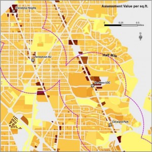
To measure Metro's impact on land markets, we analyzed property value assessment records across the region. Shown above is a sample from the District of Columbia.

A Metrorail station can make the land surrounding the station much easier to get to and from. Especially if traffic is bad and parking is costly, as often happens in our region, a Metrorail station can offer a good alternative means of getting to and from an area, which gives the area near rail an advantage over areas farther from rail. Businesses can locate near a Metrorail station and reach workers around the region, more people can live in the neighborhood and get around by transit, and customers can shop or run errands there.  Economic theory tells us that the value of land around rail stations should reflect the value transit brings, as often does the density of development.  Economists would say that the accessibility value of transit is capitalized into the land value.

But what is this effect around Metrorail stations, and how much is it worth?  How much land value is associated with Metrorail, and how much property tax revenue does this generate for Metro’s jurisdictions?

To answer, we analyzed parcel-level property assessment values across the WMATA Compact jurisdiction as part of our “Business Case” for transit study.  We analyzed all properties, including residential, commercial, and federal office buildings.  The data show that:

  • Metro enables value-creating activity: $235 billion of property value sits within a half-mile of Metrorail station
  • About 80% of this value is from commercial properties (multi-family residential, office, retail, and other)
  • 28% of the Compact Area‘s property tax base sits on 4% of its land within a half-mile of Metrorail
  • The land within a half-mile of Metrorail stations generate $3.1 billion in property taxes per year for our funding partners

New York Avenue station has helped enable valuable development. Photo courtesy of NCPPP, click for context.

This does not mean that Metro caused all of this development, but it does show that Metro serves the value-creating parts of our region. Some of this development existed before Metrorail, and influenced the decision of where to build stations.  So, we ran a number of hedonic analyses (a statistical regression technique) to isolate the effect on property values uniquely from Metrorail proximity alone, or the “rail premium.”  After all, property values can be influenced by a variety of factors, including proximity to other infrastructure, desirability of the neighborhood, etc.  Controlling for all other factors, we found that within the Compact area:

  • Metrorail boosts property values, adding 6.8% more value to residential, 9.4% to multi-family, and 8.9% to commercial office properties within a half-mile of a Metrorail station – all other things being equal
  • Property becomes even more valuable as a property gets closer to Metro stations

Others have shown too that new Metrorail stations can attract and spur economic development, by tracing the history of development around stations, such as New York Avenue and the Rosslyn-Ballston corridor.

These findings show that Metro plays a significant role in our region’s land markets: not only is valuable development and economic activity clustered around Metrorail, but the benefits of Metrorail can be seen in actual property assessments.  Our regions’ land markets recognize and have responded to the value that Metro brings.  This helps make the case that Metro is vital to the region’s economy, and is a good investment of public funds.

Read the study’s Final Report (pdf).

Cross-posted at Region Forward.

College Park Bike & Ride Under Construction

October 6th, 2011 Comments off

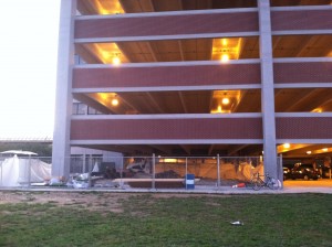
Construction has begun for a Bike & Ride at College Park garage

This week, Metro’s contractor began constructing our first secure bicycle parking facility at the College Park garage.  In the spirit of our “Park & Ride” facilities for vehicles, this facility will be called a “Bike & Ride.”

Temporary fencing is up around the site now while a new concrete slab is poured.  Steel walls are being fabricated and will be installed over the coming weeks, along with new lighting, cameras,  doors, and of course bike racks.  We should be finished with construction this winter – unfortunately just as cold weather begins to discourage many cyclists, but the timing will allow us to work out any kinks before the spring.  As with any pilot project, this will be a learning process for us and you, so bear with us as we work through the logistics. Read more…

Categories: Planning Studies Tags: , ,

Gallery Pl-Chinatown Capacity Improvements Study Underway

September 22nd, 2011 13 comments

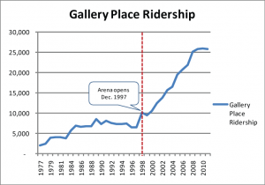
Ridership growth at the Gallery Place-Chinatown Metrorail station from 1977 – 2011.

The Gallery Pl-Chinatown Station is the third-busiest station in the Metrorail system, with an average of 26,000 daily passenger boardings in May 2011.  Combined with the Metro Center Station less than 1,000 feet away, these two stations facilitate downtown transfers on all five Metrorail lines, with the Yellow, Green and Red Lines at Gallery Place and the Orange, Blue and Red Lines at Metro Center. The Gallery Place Station consists of two side platforms that serve the Red Line on the upper level and one center platform that serves the Green and Yellow Lines on the lower level.

Redevelopment in the station area catalyzed by the opening of the Verizon Center in late 1997 has drastically increased the demand at this station, resulting in crowded conditions during the peak travel times throughout the station, including mezzanines, platforms and escalators.  Weekday ridership has increased from an average of 6,500 boardings in 1997 to an average of 26,000 in 2011. Although ridership has stabilized over the past few years, more growth is expected in the near future with new CityCenterDC development currently under construction at the old convention center site at 10th Street and H Street NW.

Metro’s planners are currently undertaking the Gallery Place Station Access and Capacity Improvement study, with the purpose of identifying capacity constraints and developing improvement alternatives at the station.  Similar to the Union Station Access Study, this study will provide simulations of the projected pedestrian environment on the platform at key milestone years, and will measure the effectiveness of the proposed capacity improvements.
Read more…

Bicycle Parking Census at Metrorail Stations

August 3rd, 2011 1 comment

Bicycle access is a key long-term access strategy to Metro’s services, and we are currently trying to triple the number of bicyclists accessing our network by 2020.  As we develop plans for capital investment in bicycle and pedestrian facilities, we need good data on bicycle parking demand to tailor new facilities to each station.  Our most recent bike parking counts were from 2006-2007, but a lot has happened since then.

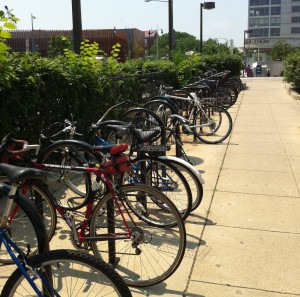
So, taking a cue from from trail count data, we counted bikes and racks at rail stations over a six-week window of peak usage from May 1 to June 15 for a “bike parking census.”  Each station was counted on a sunny, warm day typically between 9:30am and 3:00pm. We wanted to learn about the general availability of and demand for bike parking in station areas. For these counts, we specifically excluded bike lockers and the Union Station Bikestation, and focused just on racks. We wanted to know how easy it would be for a new bike-to-rail customer to easily find bike parking near a station.  We counted each U-Rack as space for 2 bikes, and used our best judgment for wave, grid, post-and-ring, and other racks.

Read more…

Categories: Planning Studies Tags: , ,

Metro Launches Parking Pilot Data

June 9th, 2011 Comments off

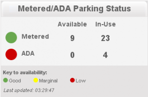
Screen capture of live parking information for Fort Totten. Click image for live site.

As part of Metro’s ongoing effort to make parking more convenient for riders, a trial of real-time sensing has been underway at the Fort Totten Metro Kiss and Ride Lot for the past few months. This system uses sensors embedded in the pavement and in parking meters to let users know when spaces are available in the Kiss and Ride Lot, and when they should save time, energy and reduce their carbon footprint by driving to a different lot or using some other mode to access Metro.  Eventually, we hope that a similar sensors and monitoring technology will be available at all Metro metered parking spaces as a customer service to riders and to improve transit access, information and use.  Information on parking space availability reduces traffic cause by motorists search for parking and reduces pollution from vehicles being driven around in the search for parking.

This real-time space availability information from the Fort Totten Kiss and Ride Lot is currently available on Metro’s website on the Fort Totten parking page:

http://www.wmata.com/rail/parking/parking_detail.cfm?station=28

Read more…

Balancing Transit Mode of Access with Urban Design in Suburban Settings: A Comparative Assessment of Four European Transit Systems

May 27th, 2011 1 comment

Metro’s early experience with promoting TOD took place at below-ground rail stations in established urban settings that did not require the provision of transit access facilities beyond connections from sidewalks to the stations below. More recently, WMATA’s opportunities to develop its land to support TOD have been predominantly in suburban rail stations that include extensive parking lots, bus bays, and facilities for taxis, bicycles, customer pick-up and drop-off, and ADA patrons.

The default agency policy in recent years has been to replace existing facilities with a like amount and kind of facilities on a reduced footprint, and to emphasize transit operational functionality over urban design issues.  For example, this approach has tended to favor placing parking structures and bus bays adjacent to the station in lieu of pedestrian facilities, public spaces and mixed-use development.  However, public feedback has prompted WMATA to reassess the appropriateness of this default approach, and there is a need for new thinking about how future patrons should arrive at suburban stations; how transit operations should function in TOD contexts; and how to better meet local development policy objectives.

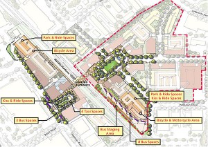
Development plan for Twinbrook Metrorail station.

Development plan for Twinbrook Metrorail station. Click the image for more information.

Over the past five years, WMATA has made a number of significant policy and program changes to recognize the changing development environment at suburban rail stations. For example, in 2008 WMATA adopted a new set of real estate development guidelines (1.91 MB PDF), and the first real estate projects implementing those guidelines were initiated in the summer and fall of 2010. While the evolution of WMATA’s planning and land development practice is underway, it is far from complete. WMATA’s most recently-launched TOD projects confront the agency with the immediate challenge of replacing first-generation, auto-oriented transit access facilities with a new generation of facilities that supports transit access, transit operations, and TOD.

Read more…

What About a Faster Transit Route Between Dulles and the Core?

March 31st, 2011 39 comments

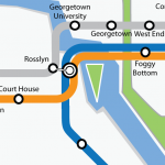
The planned Metrorail Line to Dulles Airport will provide a high-frequency, high-capacity link between the airport and the region’s core, and will enable travel between all Metrorail stations and the airport, without requiring rail-to-bus transfers.  Concerns have been expressed about the likely Metrorail travel times between the airport and the core, and the capacity of the Metrorail system, as trains converge through Rosslyn and pass under the Potomac River.  Could there be improvements that would provide faster service, expand the capacity, and also provide for greater flexibility for routing trains when service is disrupted, because of either incidents or planned major maintenance?

To attract riders, transit travel times need to “be competitive with” other travel options, yet setting that competitive bar at the level of auto travel times doesn’t seem to be necessary (nor is it readily achievable.)  Reagan National Airport attracts many transit trips, even though driving times to the airport are generally shorter than by rail.    While travel times need to be competitive, and a faster travel time would be more appealing and attract some more ridership, Metrorail to Dulles Airport will result in considerable transit usage by airport patrons and employees, not only to and from the core, but to Tysons Corner and other locations served by the Metrorail network.

Read more…

Categories: Strategies Tags: ,

“Business Case for Transit” Study Underway

March 18th, 2011 3 comments

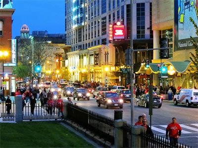
Image from Downtown DC BID

In our discussions about the costs of Metro, it’s worth stepping back and considering the regional benefits our transit system provides – beyond simply another way to get from Point A to Point B.  Against a backdrop of funding needs, a crucial question is, “how does the region benefit from continued funding of Metro?”

Since the WMATA Compact was signed in 1967, we have built a 106-mile heavy rail network, the bus and paratransit systems now cover 1,500 square miles, and together we  make around 1.2 million trips on the system every day.  Our choice to build and use transit has had broad impacts on the region: it has changed the way land is developed, where businesses choose to locate, how the economy grows, how families get around and settle in livable neighborhoods, how we impact the environment, and more. Read more…

Union Station Metrorail Access and Capacity Study

February 22nd, 2011 2 comments

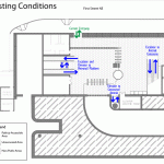
In October, we published a post about the ongoing Union Station Metrorail Access and Capacity Study, and included a pedestrian simulation showing the existing conditions at the Union Station Metrorail station’s north mezzanine.  The study has been completed, and the proposed access and capacity improvements and resultant station performance are described below

Currently, passengers traveling through the north mezzanine experience congestion on a daily basis.   Imagine what would happen at the north mezzanine in the next 20 years, once Union Station’s local and intercity travel facilities have been expanded (including the planned streetcar terminating at 1st and H Streets NE) and the millions of square feet of planned development in the surrounding areas have been completed. Our analysis shows that pedestrian volume through the north mezzanine will increase by 60%.

The biggest challenge faced by Metro during this study was to identify feasible improvements that would provide enough capacity for all users while ensuring compatibility with building functions and historical characteristics.  Metro worked with DDOT and Union Station stakeholders to develop two improvement alternatives: Partial Build and Full Build.  These alternatives are illustrated in the animated graphic below, which rotates between existing conditions, partial build and full build every 15 seconds. Read more…

RTSP Rail Enhancement Strategy: Interline Connections and Station Improvements

February 16th, 2011 7 comments

The purpose of this strategy is to allow different rail lines to operate on the same track.  This type of operation can help reduce capacity constraint on some lines and provide new connections between existing Metrorail lines.

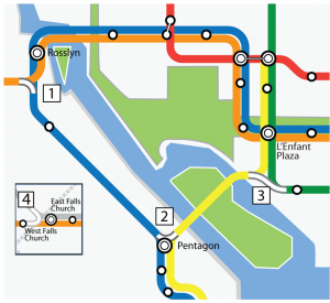
The four interline connections proposed include:

1) Connect Orange and Blue at Rosslyn
2) Connect Yellow and Blue at Pentagon
3) Connect Yellow and Green near L’Enfant Plaza
4) Connect Orange and Silver near West Falls Church

Some benefits of these interline connections include:

  1. Orange/Silver-Blue inter-lining south of Rosslyn to allow a Silver Line running between the two airports
    1. BENEFIT: Faster trip to Ballston, Tysons and airports within Virginia
  2. Blue-Yellow inter-lining north of Pentagon to allow I-66 corridor rail lines going through 14th Street Bridge
    1. BENEFIT: Utilize throughput capacity on 14th Street Bridge
  3. Yellow-Green inter-lining south of L’Enfant Plaza to allow a Yellow Line split to Anacostia/Navy Yard
    1. BENEFIT:  Allow direct access between Anacostia and southern Maryland to job sites in southern Arlington and the City of Alexandria.

Additionally, this strategy will explore the benefits of making improvements to several of the system’s core stations:

  1. Pedestrian tunnel between Farragut North and Farragut West;
  2. Pedestrian tunnel between Metro Center and Gallery Place;
  3. Increase amount of vertical capacity at Union Station;
  4. Increase transfer capacity at the three core transfer stations:  Metro Center, Gallery Place and L’Enfant Plaza
Categories: Strategies Tags: , , , ,