Archive for July, 2014

Funding Metro 2025 – Beyond Buzzwords

July 31st, 2014 Comments off

Fancy financing and accounting gymnastics won’t ride to the rescue for Metro 2025.

Public Private Partnerships.  Tax Increment Financing.  Infrastructure Banks.

These are among the many ideas discussed today as panaceas for public infrastructure funding, including major transit investment projects in the region and the nation.  Certainly they can be helpful tools, especially in an era of declining federal funds and a renewed emphasis on local fiscal austerity.  But can these tools be useful in funding or financing Metro 2025?
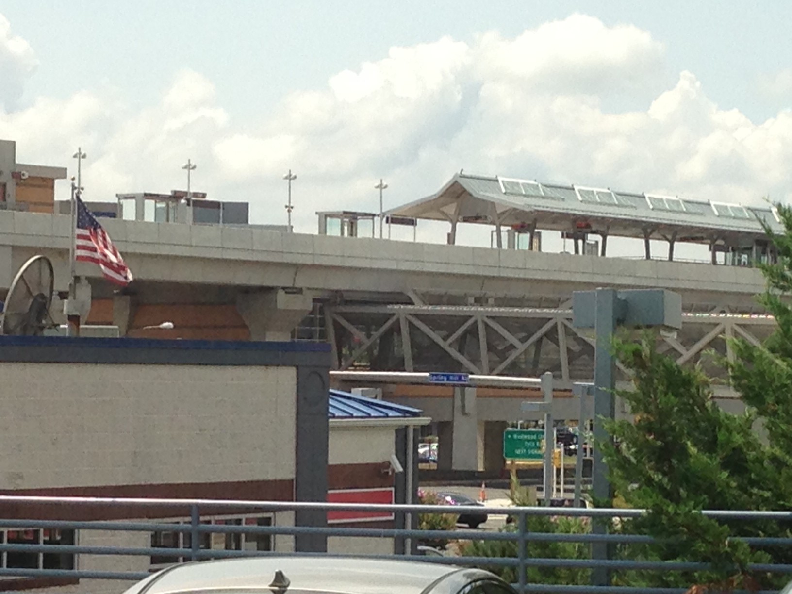
Spring Hill Silver Line station.  The Silver Line was financed in part by special tax districts.

Spring Hill Silver Line Metrorail station. The Silver Line was financed in part by special tax districts.

Metro leadership wanted to find out, so between November 2013 and January 2014, Metro gathered leading experts in real estate, transportation and municipal financing from academe, management consulting, policy advocacy and government to solicit the best ideas for innovative ways of addressing Metro’s challenge.  We learned that each of these financing techniques has differing strengths, weaknesses, and potential applications to capital projects.  We also learned that none of the techniques actually provides new funding. Which is, ultimately, what is necessary to make Metro 2025 a reality.

The distinction between financing and funding cannot be overstated, and is a key concept that often confuses the dialogue surrounding how to execute major capital projects such as transit investments.  Techniques such as Public-Private Partnerships, Infrastructure Banks, and Value Capture rely on existing sources of funding to channel and make more available monies to public entities to pay for varieties of projects.  These existing sources of funding are often taxes – either on households, businesses, or property owners – and backstopped by jurisdictional guarantees to tap into general funds or issue general obligation bonds should the stream of cashflows become unstable.  These financing techniques do not generate new monies nor eliminate the ultimate obligations of the public sector to provide the monies to contribute to the cashflows, either upfront or over time.  

You can read more in the attached report, and know that Metro’s leadership is committed to evaluating any and all options to fund Metro 2025.  Leaving no stone unturned, we conclude that as of this moment in time, regional leaders must step up to the plate and commit resources to Metro in order to make much-needed projects like eight-car trains, core station improvements, and the Metrobus Priority Corridor Network, leap off of the page and become part of the region’s transit network. 

Download:  Metro – Creative Financing (PDF, 1MB)


Ballston and the Silver Line: A Big Opportunity

July 30th, 2014 Comments off

This is a guest from Paul Mackie, communications director at Mobility Lab.

A new short video by Mobility Lab details the economic benefits that Ballston stands to reap from this week’s opening of Metro’s Silver Line.

In the video, Ballston Business Improvement District CEO Tina Leone says, “We see the Silver Line as making Ballston the center of the universe. It makes everything even better here. We already have a very active Metro stop, with 26,000 trips per day. We see that growing to 38,000 trips per day along with the Silver Line by 2020. So that’s coming very, very fast.” Read more…

Eight-Car Trains on Metro is Equivalent to Widening I-66 in Arlington by Two Lanes

July 14th, 2014 8 comments

Adding two extra cars to a six-car Metrorail train might not seem like much, but it is equivalent to widening I-66 through Arlington by two lanes. Plus, it’d likely be cheaper and faster for commuters, too.

Sometimes it’s hard to wrap one’s head around how just many people Metrorail can move. But where Metrorail operates in heavily congested corridors, seemingly small improvements can yield big results. In fact, matching the capacity of all eight-car trains system-wide would require 16-18 lanes of freeway into downtown, each way.

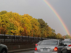
Orange Line Metro train from I-66. (Photo by wfyurasko, click for original)

To match the capacity of eight-car trains on Metro, we’d have to widen I-66 in Arlington by at least two lanes. (Photo by wfyurasko, click for original)

In Arlington for instance, going to eight-car trains on the Orange Line as part of Metro 2025 is like widening I-66 by two lanes.  Let’s do the math:

  1. One lane of highway can move around 2,200 cars per hour, at its theoretical maximum.
  2. Today, every morning Metrorail runs about 18 trains per hour eastbound on the Orange Line through Arlington, and about a third are scheduled eight-car trains. That’s a train every three minutes, and equates to around 121 rail cars per hour, or 12,060 passengers per hour.
  3. By 2025 with eight-car trains, Metrorail will be able to run 21, eight-car trains per hour eastbound on the combined Orange and Silver Lines, which equates to 168 cars per hour.
  4. This means Metro 2025 will bring the line’s capacity to 16,800 riders per hour, or an increase of 4,740 passengers per hour.
  5. To accommodate 4,740 more people on I-66 at 2,200 cars per hour, 2 people per car, we’d need 4,740 / 2 / 2,200 = 1.1 highway lanes in each direction.

That means we’d need at least two new lanes on I-66 to match the capacity of Metro 2025. In addition, eight-car trains would be cheaper, and would likely move people faster through the corridor.

  • Eight-car trains on Metro would be over two times cheaper: the estimated cost to widen I-66 works out to about $3.50 per rush-hour trip over the life of the project, whereas Metro 2025 would be about $1.50.
  • Metrorail would likely move travelers faster than I-66 in the end.  Orange Line trains today normally run at around 35 miles per hour, while congested travel speeds on I-66 average around 18 miles per hour. While new highway lanes might move cars faster at first, the improvements would eventually be eroded by growing congestion.
Categories: Impact Tags: , , ,

Study Recommends New Mezzanine to Connect Red/Purple at Silver Spring

July 10th, 2014 3 comments

To handle future ridership demand, Silver Spring may need a new mezzanine to connect Metrorail to the planned Purple Line light rail station.

Last year, we began a study looking at potential station capacity issues at Silver Spring.  The assessment determined that the demand at the Silver Spring Metrorail station (entries and exits) is adequately served by the existing station infrastructure.   Since then, the study has assessed the future conditions that will be impacted both by ridership growth due to growth of jobs and households in the station area, but also the arrival of the Purple Line light rail to Silver Spring.

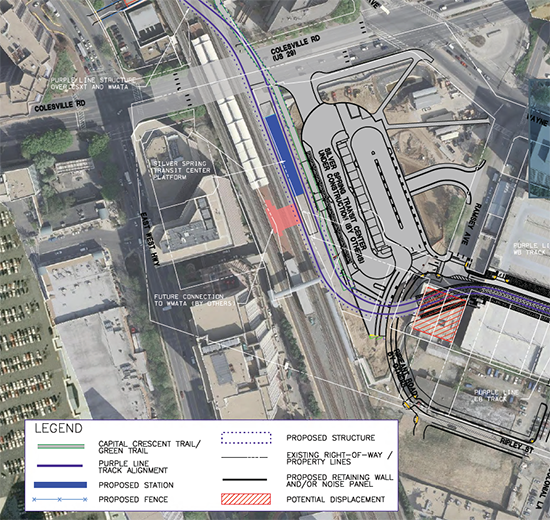
Purple Line station and potential Metrorail connection at Silver Spring.  Source, purplelinemd.com, PDF.

Purple Line station and potential Metrorail connection at Silver Spring. Source, purplelinemd.com, PDF.

The Purple Line station at Silver Spring is planned as an elevated platform and mezzanine, with the mezzanine connecting to the top floor of Silver Spring Transit Center, Metropolitan Branch Trail, and  Ripley Street to the south.   The elevated light rail platform will be approximately 80 feet above the street, about the height of the current MARC pedestrian bridge.  The MTA design team envisioned a possible direct connection between Metrorail and the Purple Line, as illustrated in the red shape in the center of the above image.  Without such a connection, riders transferring between Metrorail and the Purple Line at Silver Spring would have to descend those 80 feet to the ground level, enter an existing Metrorail mezzanine, and then ascend again to the Red Line platform. Read more…

What’s the Ideal Size for a Transit Walkshed?

July 8th, 2014 2 comments

Large transit walksheds are great, but how big is big enough?

In other posts, we have described what a transit walkshed is, and how changes can be made to the pedestrian network to increase the walkshed area.  Here, we explore how big is big enough.

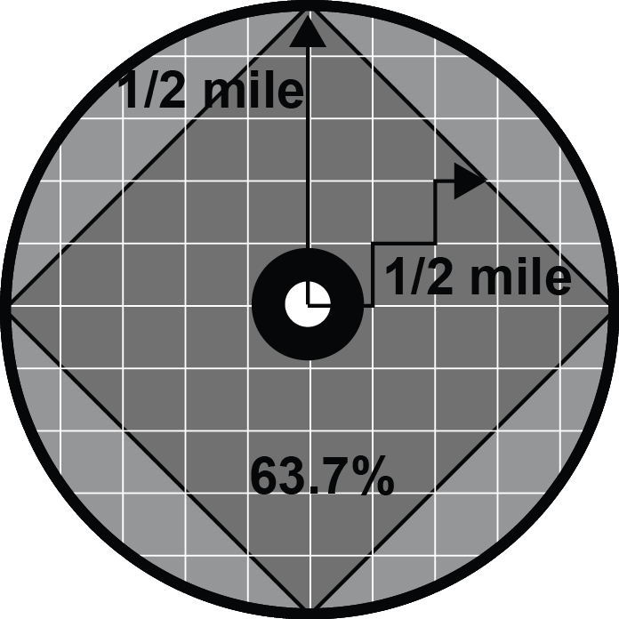
The diagram below shows a half-mile circle around a transit station.  If the station were located in a field of grass or on a massive parking lot, the walkable area of the circle would be the circle itself, 100% of the half-mile buffer around the station would be accessible by foot.  Unfortunately, that wouldn’t bode well for transit use, since there wouldn’t be any origins or destinations within that walking distance.

Ideal Walkshed DiagramNow, let’s lay a perfect grid of streets across that half-mile buffer.  The street area is where people can walk, and the remaining area contains houses, shops, mixed-use development, etc.  The resulting walkshed for the station begins to look like a diamond inscribed inside the circle.   The smaller the blocks (the closer the streets are to one another) the more the walkshed resembles a perfect diamond that has a diagonal distance equal to the diameter of the circle.  If you take the area of the diamond and that of the circle and compare them, you find the walkshed (square) covers 63.7% of the circular station area buffer.

So if you have a perfect grid and get 63.7% coverage, how can you get any better?  For one, diagonal streets can increase the coverage: if two diagonal streets were added to the grid, intersecting in the center of the circle at the transit station, the square walkshed would turn into an eight-pointed star, increasing coverage even more, but not by much.

An good example of a walkshed greater than 63.7% is that of the Takoma station.  Featured in a previous post, we recently calculated a 91% coverage for Takoma.

It is difficult to pick an ideal size for a transit walkshed.    A larger percentage could be beneficial, but the additional roadway network needed to expand the coverage beyond 63.7% may result in less area dedicated to potential transit origins and destinations.  (Remember the station in the parking lot?)

What Metrorail stations do you feel have good walkshed coverage?  In  your opinion, where can we improve?


We Had Bus Lanes a Half Century Ago and We Can Again

July 7th, 2014 9 comments

Despite having two million fewer people, our region used to have 60 miles of bus lanes.  It’s time to revive them.

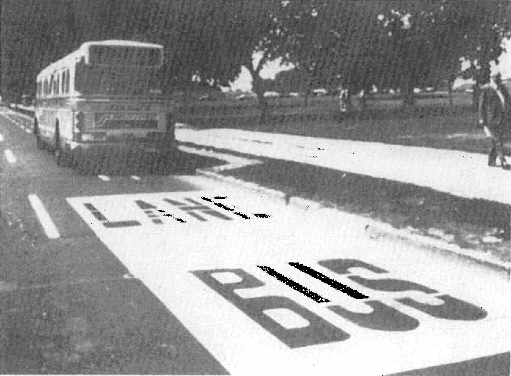
Bus Lane on 14th Street in DC

Bus Lane on 14th Street next to the National Mall in the early 1970s

Did We Really Have That Many Bus Lanes?

Yes.  In the 1960s and 70s before Metrorail was built, Washington and its surrounding inner suburbs relied heavily on its bus system to get around, with very frequent service on a number of major streets.  According to our records (linked at the bottom of this post), the first bus-only lane was installed in 1962 on 16th Street NW in DC, generally between H Street NW and Florida Avenue NW [DDOT Fact Sheet, p. 6].  This was followed by dozens of miles of rush-hour and full-time installations, as shown in the map and table below.  Streets in red indicate bus lanes that were implemented as of 1976, while streets in black and blue represent bus lanes that were planned but, to our knowledge, never put in place.

Read more…

New Blue Line Connections Revisited

July 3rd, 2014 25 comments

A recent Metro study determined that a Rosslyn bypass is infeasible but a second Metrorail station in Rosslyn to restore frequent peak period Blue Line service is possible.

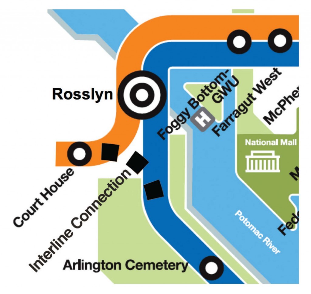
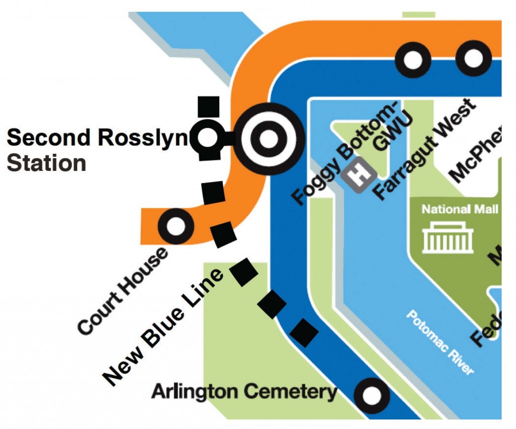
In a post last year describing the strategies in Metro 2025, we described some options for new Blue Line connections.  The first was a Rosslyn bypass that would allow some Blue Line trains to connect directly to the Orange Line at Court House.  The second was a second Rosslyn station that would connect to the current Rosslyn station via an underground walkway.  Both of these options, illustrated in the graphics below, would allow increased frequencies on the Blue Line during peak periods.

Graphic for Rosslyn Interline ConnectionGraphic for Second Rosslyn Station

Metro recently completed a study that evaluated these two options (pdf).  The bad news is that the Rosslyn bypass (interline connection) was deemed infeasible.  This is due to the location of building foundations and the turning radius required by the track.

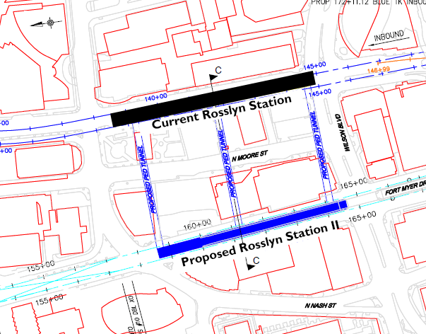
However, the second Rosslyn station was deemed feasible, as illustrated in the map below.

second_rosslyn

Location for a proposed second Rosslyn Station, including three potential options for a pedestrian walkway.

This new Metrorail station would connect to the current Rosslyn station via one underground walkway.

Metro Office of Planning is submitting the second Rosslyn station for project development funding.


How Can The Coverage of Transit Walk Sheds Be Increased?

July 1st, 2014 2 comments

Pedestrian infrastructure can cost-effectively increase coverage of transit walk sheds.

The roadway networks of most station areas are mostly unchangeable.  Existing structures on private property create unmovable barriers and  usually prevent new roads from being added to the network.  However, there is still opportunity to add pedestrian facilities that would increase a station’s walk shed in a relatively cost-effective way.

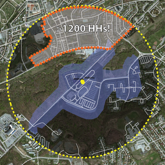
Take the example of Southern Ave Metrorail station.  We previously noted how a large number of customers drive to the station from between one and three miles away.  We discussed several reasons for this tendency to drive to Southern Ave, including the proximity to parks on both sides of the station.  The map below shows the transit walk shed of Southern Ave station.

Current walkshed of Southern Ave station.  The area with the orange dotted border contains over 1,200 households that could be within a half mile of Metrorail if a direct pedestrian connection were built.

Current walkshed of Southern Ave station. The area with the orange dotted border contains over 1,200 households that could be within a half mile of Metrorail if a direct pedestrian connection were built.


But what if a pedestrian path could be built to connect the station to the neighborhood to the north?

If a well lit, safe pedestrian path were constructed between the station and the orange-dotted area on the map, it could expand the walkshed to include up to 1,200 additional households in DC.  This new connection would likely increase ridership at Southern Ave. and might even generate enough additional fare revenue to fund the construction of the trail.

Metro’s Office of Planning is currently evaluating the walk sheds of our rail transit stations.  What other opportunities do you see for cost-effectively increasing the walk sheds around Metrorail stations?