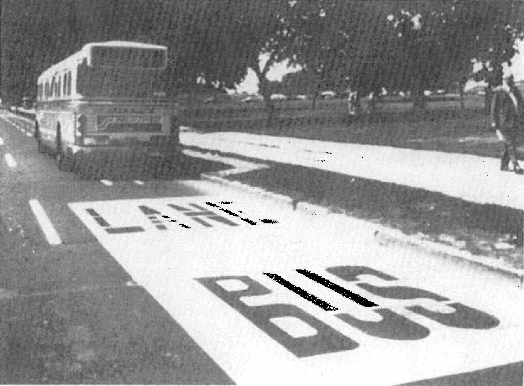
Despite having two million fewer people, our region used to have 60 miles of bus lanes. It’s time to revive them.
Bus Lane on 14th Street next to the National Mall in the early 1970s
Did We Really Have That Many Bus Lanes?
Yes. In the 1960s and 70s before Metrorail was built, Washington and its surrounding inner suburbs relied heavily on its bus system to get around, with very frequent service on a number of major streets. According to our records (linked at the bottom of this post), the first bus-only lane was installed in 1962 on 16th Street NW in DC, generally between H Street NW and Florida Avenue NW [DDOT Fact Sheet, p. 6]. This was followed by dozens of miles of rush-hour and full-time installations, as shown in the map and table below. Streets in red indicate bus lanes that were implemented as of 1976, while streets in black and blue represent bus lanes that were planned but, to our knowledge, never put in place.
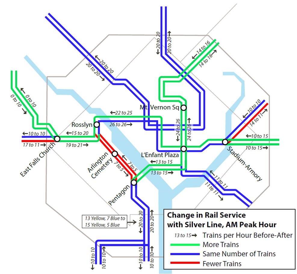
Recent and upcoming Metrorail service changes to accommodate the Silver Line have been in the works for over a decade, and are better for Blue Line riders than originally planned.
Metrorail Service Changes with the Silver Line Opening on July 26, 2014
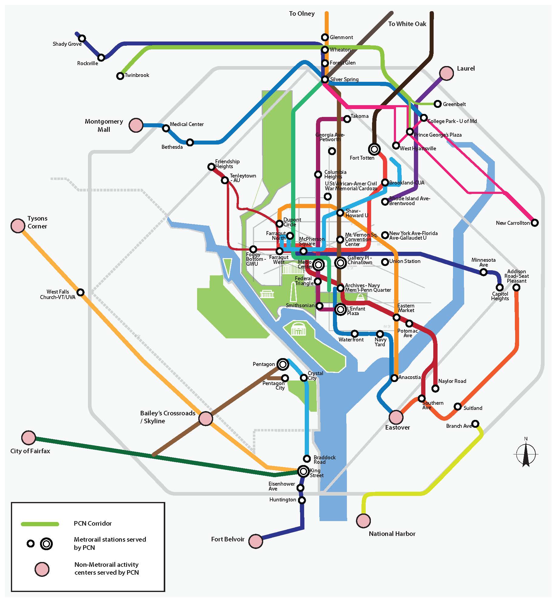
Metro is conducting rider surveys in support of a new study examining late night bus service, generally defined as operating between 11pm and 4am, with a focus on Metrobus service generally inside the Beltway and during the time period after Metrorail closes (after midnight during the week and 3am on weekends). The study will examine the performance of existing late night Metrobus service, connections among bus routes and between late-night activity centers (see map below), and the potential for 24-hour bus service, and for branding late-night bus service. The study will also make recommendations for near-term service improvements. Riders of many of the most heavily used Metrobus routes may have noticed surveyors at major bus stops as in-person surveys were conducted from approximately 11pm to 4am over the past week. Read more…
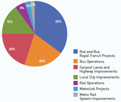
The Los Angeles area is aggressively leveraging billions in local tax dollars to transform the region into a more vibrant place with a variety of transportation options.
Measure R Spending Breakdown
The conventional wisdom today is that the days of big expensive transportation investments are over. Los Angeles apparently didn’t get the memo. The main transportation planning and development agency in the LA area, the Los Angeles County Metropolitan Transportation Authority (LA Metro), is currently leading the development of the nation’s largest regional transportation expansion program. The program of projects, Measure R, was overwhelmingly approved by more than two-thirds of LA county voters in 2008, and raised the local sales tax one-half cent. The half-cent sales tax is expected to raise $40 billion over 30 years (including an estimated $590 million in 2012) to provide the lion’s share of funding for Measure R transportation projects around the region, helping Angelenos avoid some of the area’s legendary traffic congestion. Not satisfied with the already impressive pace of expansion, LA Metro’s Board of Directors is now exploring a second ballot measure that could come as early as 2016.
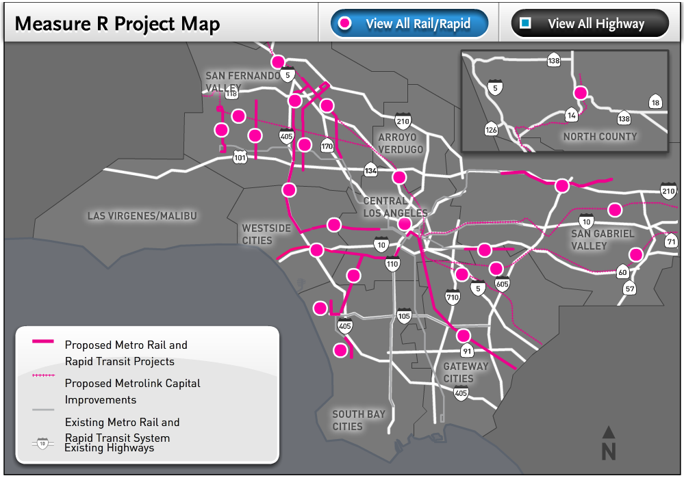
Measure R includes an impressive array of transit projects, including the Orange Line Bus Rapid Transit extension, Expo and Regional Connector light rail lines, and the Westside Subway, among others. Below is a map of the transit projects fully or partially funded by Measure R (click on the map below for the interactive version):
The American Automobile Association (AAA) highlights that, even with a proposed fare increase, Metro is still a cheaper than driving for many trips in the region.
AAA’s analysis compares the costs of driving and parking between Maryland and Virginia to Metro-accessible locations in and near downtown Washington. Below is a selection of these trips:
Comparing The Commuting Costs – Driving vs. Riding Metro (Source: AAA Mid-Atlantic)
Obviously, these are just examples and there are other trips where transit isn’t an option or driving may be more cost effective than Metro. Parking costs, levels of congestion, transit accessibility, travel times and other variables are quite different depending on where a trip begins and ends. Still, taking the train or bus is often much cheaper than driving, especially utilizing SmartBenefits or transit passes, which further reduce the cost of choosing Metro
Priority treatments speed up buses, which saves everyone time and money, uses street space most efficiently, and attracts development.
Bus priority projects, such as those begun through the regional TIGER grant and included in the Metrobus Priority Corridor Network Plan, will improve travel times, increase service reliability, and attract thousand of new riders once fully implemented.
But let’s step back for a moment. Why are these improvements needed?
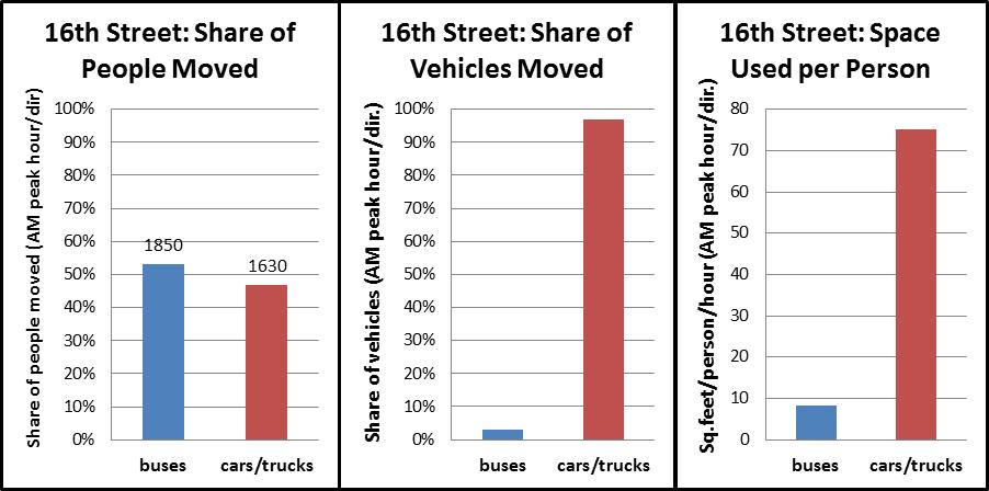
During the morning rush hour, Metrobus carries 50% of all of the people traveling on 16th Street NW towards downtown DC, despite using just 3% of the vehicles. However, it still gets stuck in traffic.
It will come as no surprise to regular riders of the Metrobus S1,2,4 (PDF), or MetroExtra S9 (PDF), but ridership has grown tremendously in recent years on 16th Street, from just over 16,000 riders per weekday in 2008 to about 20,500 this year. To keep pace, Metro has added lots of new service, most notably the S9 limited stop service in 2009.
Metrobus’ Priority Corridor Network (PCN) Plan will improve bus service, travel speeds, and reliability on 24 regional corridors, which serve half of Metrobus ridership. Improvements include:
Improved operational strategies such as transit signal priority and exclusive bus lanes
Increased frequency and span of service
Improved customer information
Added MetroExtra, Metro’s limited-stop bus service, routes and buses
Expanded fare payment options
Added safety, security and incident response measures
We were made aware of this video entitled, “Metro: Here and Now.” Take a look:
The video contains footage on the initial operating segment of the Metrorail Red Line from Rhode Island Avenue-Brentwood to Farragut North, with a strip map including Dupont Circle as well as several shots of Metro Center. So we can surmise that Given some of the points made in the comments, the video probably dates from 1976 sometime in the period from 1975 – 1977, around the time that first rail segment opened in 1976. Aside from the interesting clothing and hairstyles of the time, one of the things that stands out is the operation of 2-car trains. This is difficult to imagine today, when 6-car and 8-car trains are the norm during all operating periods, and plans are being developed as a part of Metro’s Momentum Plan to operate 100% 8-car trains during peak periods.
Another interesting feature of the video is the landscape surrounding some of the stations. While the properties near Judiciary Square, with the DC courthouses, the National Building Museum, and Metro’s Jackson Graham Building appear mostly unchanged today, other station areas look different. At 8:44 in the video, you can see a train pulling into the (temporary) terminal station at Rhode Island Avenue. At 8:50, you can see the surface parking lots to the east of the line where a recently built joint development project now sits.


")

Recent Comments