Our new “Line-Load Application” is expected to provide more accurate reports of system crowding by segment.
We recently finished testing a new version of the Line Load Application, a custom-developed application that distributes the load of passengers across the Metrorail system based on their points of entry and exit. This application allows us to estimate the passenger loads on rail system per segment (rail between stations). It is very important for Metro to be able to track the passengers per car across the rail system, both for peak hours on average weekdays and before and after special events. Because the new system is based on rail schedules, each passenger is assigned to an individual car for the assessment of passengers per car (PPC).
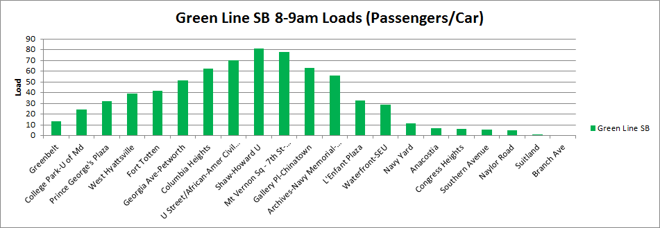
Example of southbound Green Line passenger loads, May 1, 2013, 8am-9am
Our current method of assessing passenger crowding is by stationing rail passenger counting personnel at key stations during peak periods, approximately twice per month per station. Because the inputs to the new application are faregate entry and exit data, this application is providing data like Metro has never seen before, including load factors and passengers per car for all stations at all times of the day.
Upon review, the output data from this tool appears to match expectations of passenger loads at major checkpoints in the system during peak periods with no disruptions. Output from this tool covering non-core checkpoints and non-peak periods will be validated soon.
In the next phase of improvements for this application, we will work to incorporate actual train arrival and departure times as an alternative to using schedules. This will allow us to understand the actual conditions our customers experience during service disruptions or after special events.
The completion of the development of the Line Load application comes at a point in time when Metro is striving to increase safety and relieve the crowding on the rail system, both of which are major topics of our new strategic plan, Momentum.
 The District Department of Transportation (DDOT) is hosting its third and final round of public workshops in October to discuss moveDC, DDOT’s initiative to develop a strategic, multimodal long range transportation plan for the District. The public is encouraged to attend a workshop to review the draft plan and help prioritize the transportation options. The October workshops will enable you to:
- Share your ideas and observations on future plans for transportation;
- Learn how three approaches to a future DC transportation system perform;
- Review the results of our survey research;
- Provide input into the draft transportation plan; and
- Learn more about the moveDC local bus study.
Online Survey
Throughout October, you are also invited to participate in a survey to comment on and critique three approaches that have the potential to transform the way people travel in the District.
Public Meeting Dates and Locations
Monday, October 21
7:00 a.m. to 6:00 p.m.
Union Station
625 First St NE
Tuesday, October 22
6:30 p.m. – 8:30 p.m., with a formal presentation 7 p.m.
Dorothy I. Height/Benning Neighborhood Library
3935 Benning Road, NE
Saturday, October 26
1:00 p.m. – 4:00 p.m.
DCUSA Retail Center, 2nd Floor, between Target and Best Buy
3100 14th St. NW
Wednesday, October 30
6:30 p.m. – 8:30 p.m., with a formal presentation 7 p.m.
Petworth Neighborhood Library
4200 Kansas Ave., NW
Web Meetings
Visit www.wemoveDC.org for more details and to sign up.
October 24, noon – 1:00 p.m.
October 28, 7:00 p.m. – 8:00 p.m.
Categories: In The News Tags: access, bike, bike parking, BRT, bus, meetings, Metrorail, pedestrian, planning, plans, presentations, public comment, rail, stations, tod
This is the first post in a two-part series based  on content from the tenth meeting with the Regional Transit System Plan (RTSP) Technical Advisory Group (TAG) that was held in July. This post will focus on our analysis of Metrorail capacity and crowding, while the second post will focus on identifying and prioritizing regionally significant surface transit corridors.
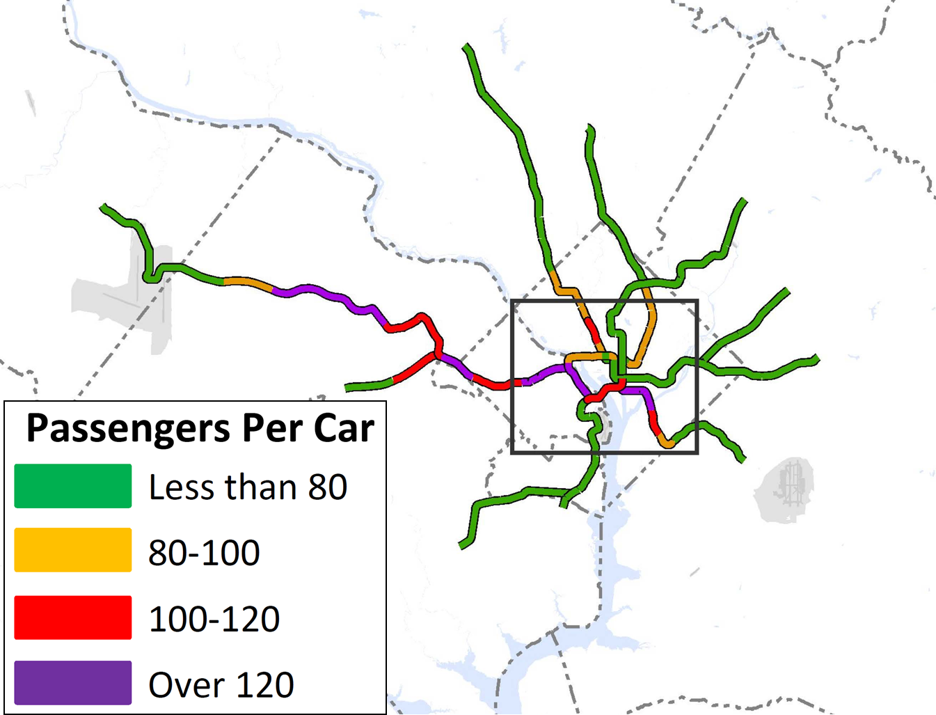
By 2040, ridership and crowding levels on Metrorail indicate the need for a new Blue Line and new Yellow line in the system’s core and a third line in Virginia.
At the time of our last post, we had run an initial round of four scenarios that sought to resolve regional mobility issues. We gathered a lot of information from the results, but realized that we needed to run a second round of scenarios focused almost entirely on Metrorail. Using MWCOG’s Cooperative Forecast Round 8.1 land use, which has been adopted by the region, and MWCOG’s Aspirations land use, which shifts more jobs and households into the regional activity centers, the maps below clearly demonstrate crowded conditions in 2040. The Base Network shown in these maps includes 100 percent eight-car trains and all the CLRP projects. Crowded conditions exist on the Orange Line west of Rosslyn, on the Yellow and Green Lines south of L’Enfant Plaza, and on the Silver Line west of Tysons. Because the results indicated that Metro would be severely crowded EVEN if we run the longest possible trains (eight-car trains), we wanted to explore other long-term solutions.
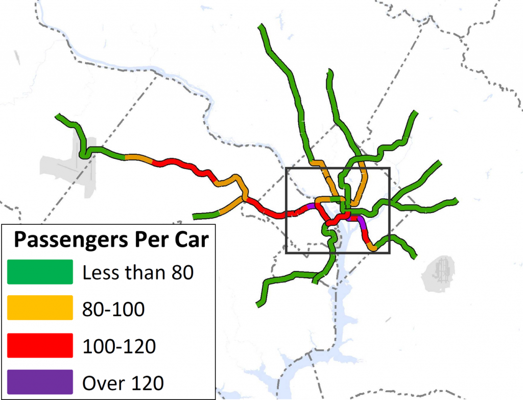
Crowding on Metrorail by 2040, even with the longest possible (eight-car) trains. Base Network AM Peak, Round 8.1 Cooperative Forecast

Crowding on Metrorail in 2040 even with the longest possible (eight-car) trains, Base Network AM Peak, Aspirations Land Use
Read more…
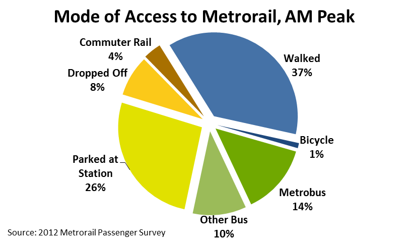
 Two-thirds of Metrorail riders take transit, walk, or bike to Metrorail for their morning commute.
Every morning, thousands of people walk through the faregates and into Metrorail. Did you ever wonder how they get to their station? Our 2012 Metrorail Passenger Survey tells us the answer to this question, for the morning rush:
- More than a third (38%) of Metrorail riders get to the station in the morning by walking or biking.
- Another quarter arrive by bus – Metrobus, as well as other bus operators in the region.
- Another third arrive by car – most by parking at or near the station, but some by getting dropped off.
- Finally, about 4% of riders arrive via commuter rail – mostly at Union Station.
Of the 25,000 or so daily riders who access rail by “Other Bus,” the top three contributors are Fairfax Connector (6,700), Montgomery County’s RideOn (5,700), and private shuttles (4,900). Of those who parked at their station, one-third were driving from less three miles away. Carpooling to Metrorail is very low – we estimate average vehicle occupancy at 1.03 passengers per parked car.
The map below shows how the answer to “How Did They Get to the Station?” varies dramatically station to station. (For the sake of legibility on this map, I’ve simplified the access modes into 4 groups). Read more…
Delivering the transit system that  the region needs will require an unequivocal commitment of additional resources from internal and external stakeholders. Simply put, the rehabilitation work being accomplished at the time of the writing of this document will not be nearly enough to keep up with the region’s needs, and without additional resources it will be unlikely that the region can continue to enjoy a transit network that contributes to competitiveness and makes the Washington metropolitan area one of the most desirable places to live and work.
Metro – Doing Business Differently
Metro recognizes that rebuilding the region’s transit system also means rebuilding the region’s transit authority – and will continue to be hard at work on this task in preparation for the implementation of Momentum. In the near term this means revamping nuts and bolts elements of the authority, including but not limited to: identifying ways that Metro can do its job more efficiently while increasing performance; evaluating its contracting and procurement philosophy to emphasize lifecycle contract and asset management; engineering a budgeting process that allows Departments to strive to achieve the goals of Momentum within the context of tight fiscal and financial discipline; and a human capital strategy that must have the right talent in-place and in-queue. In the long term, this means completing the journey to a much more business-like operating and execution philosophy for the organization.
The year 2040 may seem distant and removed, but in the context of transit planning, it is right around the corner. Metro’s Office of Planning is in the process of developing the 2040 Regional Transit System Plan (RTSP), which will outline a comprehensive regional transit network to prepare the region’s transit system for continued growth.
The RTSP, along with other elements that may be identified in the future, will need to be evaluated as necessary to meet the demands in the future. The plan includes a combination of core system improvements, which are included as part of Metro 2025 above, as well as system connectivity and expansion projects. Most importantly, it combines all modes in the region’s transit system, whether or not Metro will build or operate them. The strategies in the plan are designed to both serve existing areas better and provide service to new areas, helping to realize Region Forward’s vision of regional activity centers with transit options that improve regional mobility, enhance commerce and competitiveness, and have environmental and health benefits for generations to come.
Read more…
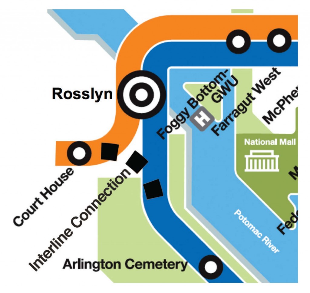
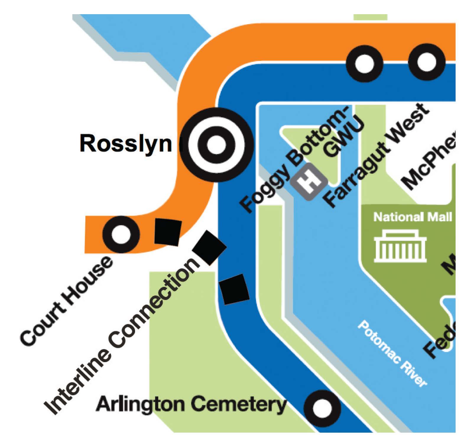
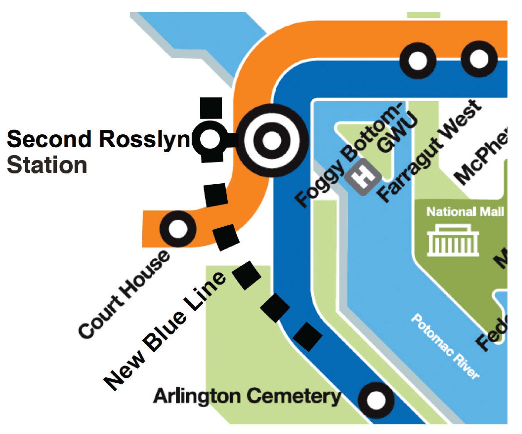
Adding new Blue Line connections seeks to restore train frequencies to every six minutes during the peak period between Pentagon and Rosslyn stations, resulting in less waiting time and crowding for Blue Line riders in Northern Virginia. Once the Silver Line opens, the Blue Line service will operate every 12-14 minutes as opposed to the previous six minutes. The feasibility analysis is currently underway and has identified two potential alternatives to create new connections:
- Alternative 1: Add rail track that would create a new connection between the Blue and Orange/Silver Lines, or
- Alternative 2: A second Rosslyn Station for a new Blue Line with an underground passageway to the existing Rosslyn station, which would connect to the Orange/Silver Lines with a pedestrian tunnel.

Read more…
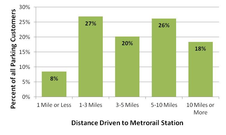
One-third of Metro parking customers drive from less than three miles to their station. But Metro’s importance can also be seen far across the greater Washington region, in this new visualization of parking customer’s origins.
Most Metrorail parking facilities primarily serve the neighborhoods immediately surrounding the station: 64%55% of parking customers come from less than five miles away, and 47%35% come from less than three miles away. However, some riders come from much farther away, particularly to end-of-line stations near major highways, such as Greenbelt, New Carrollton, and Vienna.
With approximately 60,000 parking spaces, Metro is one of the region’s largest parking operators. Our 2012 Metrorail Passenger Survey provides good insight into the travel patterns of rail customers, including those who drove and parked at any of Metro’s 35 stations offering daily parking. These parking customers represent around 15% of all rail trips on a typical weekday.
Read more…
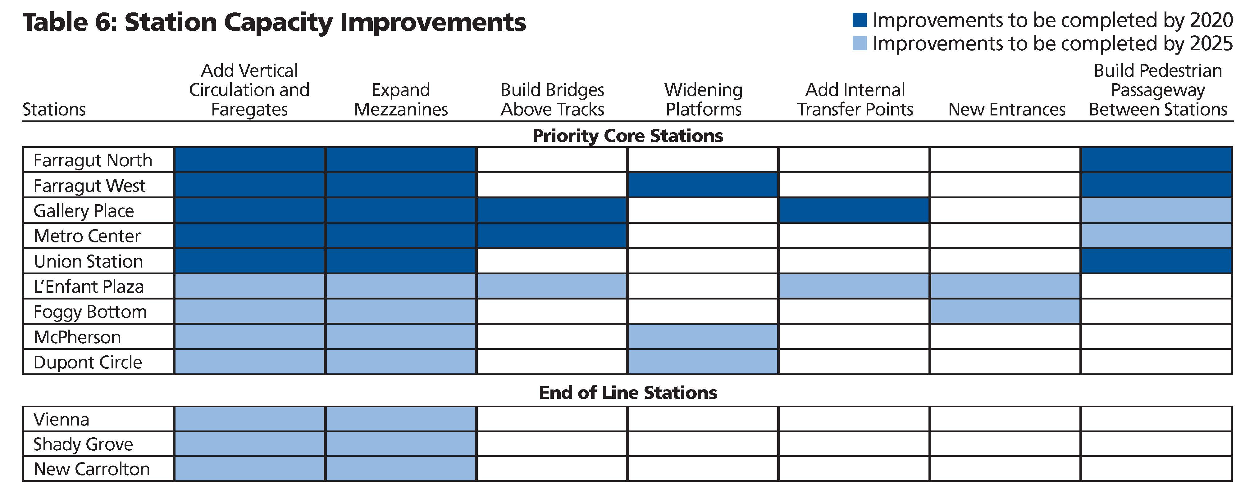
Improving and expanding capacity at high ridership stations will ensure safe and efficient operations and facilitate passenger movements from street-level to platform as well as transfers between lines. The proposed stations, most of which are in the system’s core, already experience crowding or would reach capacity by 2025. Proposed improvements vary from adding escalators and stairs to building pedestrian passageways connecting platforms within a station and between stations.

 You’ve been diligently telling us what you think our priorities should be and we’ve listened. We’ve been hard at work putting the final touches on Momentum: The Next Generation of Metro and Metro’s Board endorsed the plan today.
Starting Monday, over the following 40 weekdays, we’ll be rolling out the most interesting parts of the plan in daily posts here on PlanItMetro.
Monday Posts: Preparing for Tomorrow’s Region Today
Tuesday Posts: Metro’s Importance to the Region
Wednesday Posts: Metro’s Recent Accomplishments and Public Engagement
Thursday Posts: Strategies and Priority Actions to Make this Vision a Reality
Friday Posts: Metro 2025 – Seven Priority Capital Initiatives
If you want to read and download either the full Momentum plan or the Executive Summary, go right ahead. But if you want to stop back for a daily dose of Momentum, don’t be shy. If you notice something that strikes your fancy, leave us a comment.
Regional support is important to making Momentum a reality! A number of regional stakeholders have already endorsed Momentum. Please sign on and add your name to endorse Momentum and send the message that public transit is vital to the National Capital Region.
Categories: Momentum Tags: 40 Days of Momentum, Board, business case, forecasts, history, maps, Metrorail, MindMixer, Momentum, planning, plans, priority, public comment


Recent Comments