The Washington Metropolitan Area Transit Authority (WMATA) seeks energetic individuals to join its Department of Planning and Joint Development to advance the Authority’s vision of improved and expanded public transit services.
The Senior Planner position manages and conducts transit systems planning analyses, transit facility and corridor improvement projects, and other transportation planning studies. In addition, the Senior Planner participates in regional planning activities that include coordination with federal, state, regional, and local agency representatives and other stakeholders. This is a highly responsible professional position involving technical planning, project management and advocacy work of a complex nature.
Candidates for the Senior Planner (ref.# 120350) should have experience with and knowledge of regional and corridor planning, transit project development, systems planning studies, quantitative analysis, and project management. For more details or to submit an application online, visit http://www.wmata.com/careers/metro_jobs/
Closing date is April 12, 2012.

Metrorail Core Capacity: One issue discussed by the Board today.
The Metro board kicked off a strategic planning process today at a special 10 AM session. Staff presented the board with a history of regional visioning efforts, growth forecasts, an assessment of the role of Metro in the regional transportation network, and an assessment of how the region would look if there were no transit.
The remainder of the presentation covered a series of issues currently being faced by Metro and the region as a whole, including:
- Constrained core capacity
- Last mile(s) station access
- Inefficient surface transit
- Coordination of streetcar and lightrail projects
- Serving emerging activity centers with high quality transit
- The rising costs of operations and maintenance
- Unfunded capital needs
An annotated PDF of the presentation is available for download. You can also listen to the presentation and the board’s subsequent discussion.

Screen capture of live parking information for Fort Totten. Click image for live site.
As part of Metro’s ongoing effort to make parking more convenient for riders, a trial of real-time sensing has been underway at the Fort Totten Metro Kiss and Ride Lot for the past few months. This system uses sensors embedded in the pavement and in parking meters to let users know when spaces are available in the Kiss and Ride Lot, and when they should save time, energy and reduce their carbon footprint by driving to a different lot or using some other mode to access Metro. Eventually, we hope that a similar sensors and monitoring technology will be available at all Metro metered parking spaces as a customer service to riders and to improve transit access, information and use. Information on parking space availability reduces traffic cause by motorists search for parking and reduces pollution from vehicles being driven around in the search for parking.
This real-time space availability information from the Fort Totten Kiss and Ride Lot is currently available on Metro’s website on the Fort Totten parking page:
http://www.wmata.com/rail/parking/parking_detail.cfm?station=28
Read more…
The Washington Metropolitan Area Transit Authority (WMATA) seeks energetic individuals to join its Department of Planning and Joint Development to advance the Authority’s vision of improved and expanded public transit services.
The Senior Planner position manages and conducts transit systems planning analyses, transit facility and corridor improvement projects, and other transportation planning studies. In addition, the Senior Planner participates in regional planning activities that include coordination with federal, state, regional, and local agency representatives and other stakeholders. This is a highly responsible professional position involving technical planning, project management and advocacy work of a complex nature.
Candidates for the Senior Planner (ref.# 110295) should have experience with and knowledge of regional and corridor planning, transit project development, systems planning studies, quantitative analysis, and project management. For more details or to submit an application online, visit http://www.wmata.com/careers/metro_jobs/
Closing date is April 29, 2011.
 In 1997, the WMATA Board of Directors appointed the Regional Mobility Panel. Made up of members from regional governments as well as business, labor and citizen leaders, the panel was charged with reducing costs and increasing integration of the region’s bus services. In addition to publishing Principles for Coordinated Bus Service in the Washington Metropolitan Area, the panel also identified the need for service planning processes and procedures. The panel recommended service criteria be developed to allow evaluation of regional bus service provided by WMATA. (Regional routes cross jurisdictional lines and are subsidized by all compact jurisdictions.) In consultation with the local jurisdictions the following criteria were developed and integrated into Metrobus Service Adjustment Policies, adopted by the WMATA Board of Directors in February, 2000.
While the criteria were established to evaluate productivity of regional routes, Metro also evaluates non-regional routes the same way. However, routes of a given service type (regional vs. non-regional) are evaluated against average performance criteria of only its own service type. These critical values are calculated annually based on past years’ performance.
- Daily Weekday Passenger Boardings
- Cost Recovery
- Average Subsidy Per Passenger
- Passengers Per Revenue Trip
- Passengers Per Revenue Mile
For a more detailed description of these criteria, please see the Metrobus Service Guidelines document.
Report of the Regional Mobility Panel, 1997 (PDF, 1 MB)
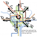
The Metro board recently received a staff presentation containing some options for narrowing the projected gap in the fiscal year 2012 budget. One of these options, the elimination of weekend late-night service, garnered a lot of attention in the media and on the local transit blogs. A lot of the discussion centered around understanding who these passengers are (late night revelers, night shift workers), where they’re starting their trips and where they’re ending them. Others discussed what other transit alternatives might be viable replacements for Metrorail late-night service.
One local blog, Greater Greater Washington, posted a great diagram generated by one of their contributors that illustrates total station volumes for late night trips and helps see whether a station is an origin station, a destination station, or in the middle. The map does a wonderful job of illustrating origins, destinations and volumes, but leaves one question unanswered: what sorts of trips are actually being made?
Read more…

Embedded sensor, currently being tested at Fort Totten Kiss and Ride metered parking spaces.
One of the challenges Metro faces is how to best support Parking customers. Good data on parking space utilization at metered Kiss and Ride spaces can be hard to come by and finding a metered parking space at many stations can involve guesswork. To address this lack of space availability information, Metro is beginning a 1-year pilot of sensors in parking spaces at the Fort Totten Metro Kiss and Ride parking lot to capture data on space availability and usage and to facilitate payment. These battery-powered sensors will be mounted flush with the pavement in each parking space, and communicate information on availability and usage. These space sensors will last 5-7 years on their internal batteries, and provide nearly real-time information. Read more…
As described in a previous post, Metro has recently completed the first phase of implementing the new bus stop design and placement guidelines. This first phase included consolidating bus stops along four routes in the District of Columbia. As noted before, these routes were chosen because they have the highest number of stops per mile within the Metrobus system.
Below is a complete listing of the bus stops that were removed. As suggested before, please let us know in the comments of other corridors or segments of bus routes that you feel have stops too often. Read more…
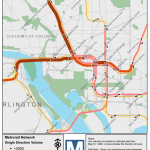
More than two-thirds of daily ridership occurs during the morning and evening peak periods. In fact, the peak ridership is a key determinant to Metro’s operating plan and future system planning efforts. An assessment of peak passenger ridership allows Metro to locate areas of current and future peak-period passenger crowding, and then plan to develop and fund capital projects aimed at addressing these capacity-constrained locations.
In 2009, Metro’s Office of Long Range Planning developed a tool to estimate passenger ridership on individual rail segments based on the station-to-station origin-destination data in the ridership database. The tool approximates passenger volume by peak hour and period. Then we use GIS to map the link-level passenger volumes.
Read more…
The Metrobus system is a robust network of surface transit lines that provide service to a variety of markets. Each different market is best served by a different type of bus service. Some bus routes only operate during the peak periods, while others operate from early morning to midnight. Some routes provide limited-stop commuter service, while others stop frequently every other block. Some routes provide only a few bus trips per hour, while others run every 10 minutes on a fixed frequency.
Metrobus lines provide a variety of services, and the current Metrobus map is designed to show all routes without regard to the service types and the markets they serve. Metro is aware that different travel markets could benefit from maps illustrating the bus service best suited to them.
Perhaps the market most in need of specialized maps and traveler information is the casual/off-peak rider. While commuters place the heaviest load on the bus system and tend to have very rigid schedules, the casual rider has no fixed schedule and travels during the off-peak times when service exceeds demand. This makes the casual rider the most inexpensive to serve, yet most difficult. The casual rider wants convenient, point-to-point travel options any time of the day without having to consult a timetable. A “12-minute” map can provide the casual rider with the information she needs to make her trip.
Read more…


Recent Comments