
Rhode Island Avenue – an Opportunity to Truly Connect Communities (and Bolster WMATA Finances)
Low-cost planning maneuvers could increase transit-accessibility for one thousand households and save the region $1.3 million per year!
We recently covered an exciting development project in Northeast D.C., one that will create housing and jobs right next to the Rhode Island Avenue Metro station. Because the site is located within the station’s half-mile walk shed, all those new residents, employees and shoppers are likely Metro customers, whose fares will help improve the system for everyone.
But is that the end of the story?
In our analysis of station walk sheds — the area within a half-mile walk of the station — we discovered that the Rhode Island Avenue walk shed is constrained by physical barriers that force pedestrians to make lengthy detours. The most notable of these is a retaining wall along the northern edge of the redevelopment site (currently the Rhode Island Center shopping mall):
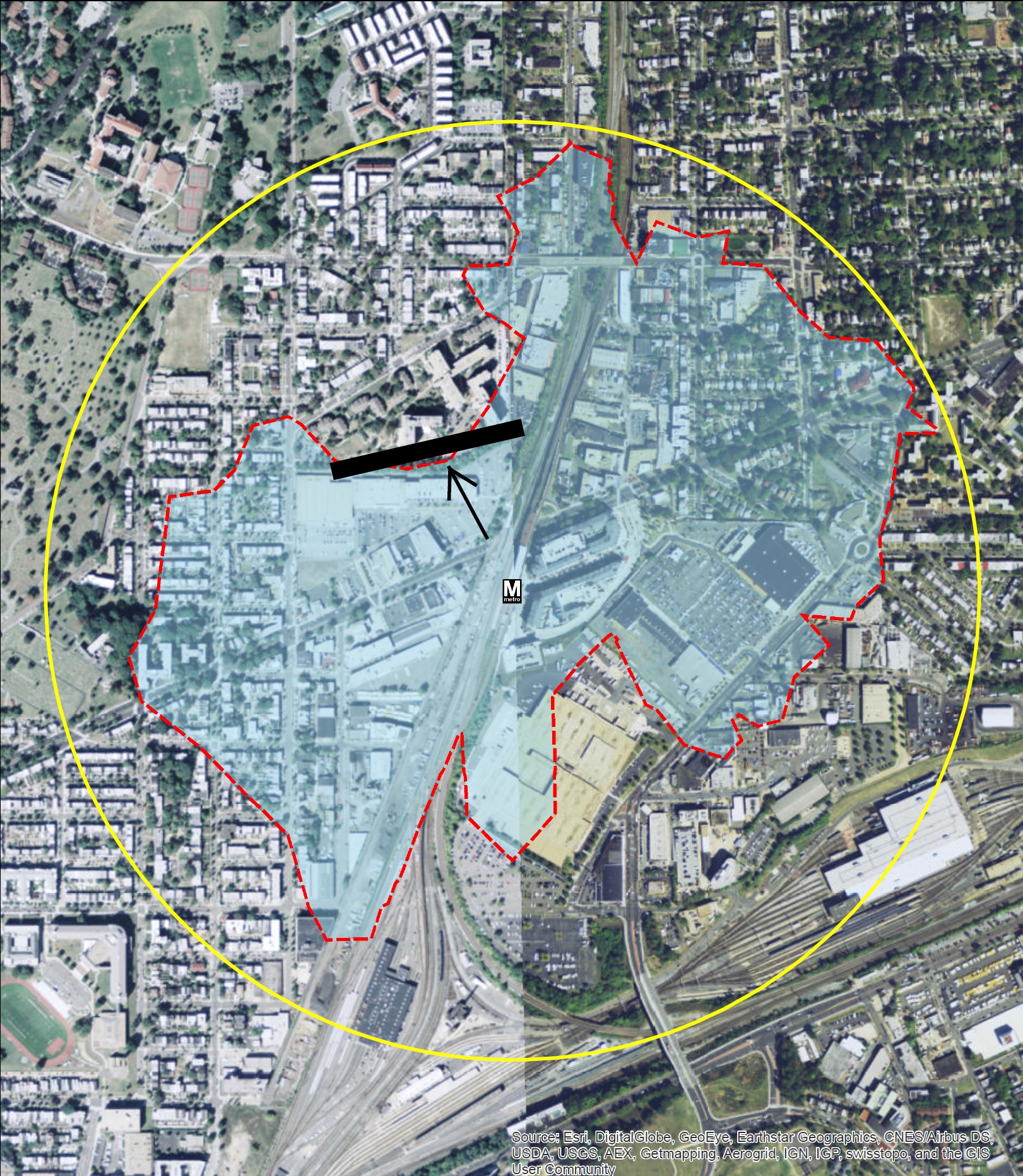
Current walk shed of Rhode Island Ave station, with illustration of the retaining wall.
For Edgewood residents living immediately to the north, walking to the Rhode Island Avenue Metro requires a detour around the barrier that inflates the walking distance by up to half a mile – making the total walking distance a full mile or more. While some choose to make the long hike to the station, we know that people are significantly more likely to use Metro if the station is within the half-mile walk shed.
This led us to ask: What if we make a pedestrian connection through that wall part of the large-scale redevelopment?
While building a pedestrian link through a retaining wall is certainly no easy project, it’s one that could make Metro more accessible for over 2,000 Edgewood residents. In terms of the station walk shed, a short pedestrian connection would dramatically expand coverage:

Potential walk shed of Rhode Island Ave station with connection created through the retaining wall.
This proposed connection would increase the number of households in the walk shed 1,200 to 2,200 (a whopping 54% increase) while increasing the coverage ratio (area of red blob divided by area of yellow circle) by 8 percentage points, from 45% to 53%.
For Metro, the creation of this connection could result over 1,800 additional weekday trips using Rhode Island Avenue (as estimated by the Land Use Ridership Model, which we’ve discussed before). In terms of fare revenue, this translates to $1.3 million annually. For residents of Edgewood Terrace and nearby areas, a new connection could mean greater access to jobs and services throughout the region, not to mention the retail in the future Rhode Island Center development.
Can you see any challenges with creating such a connection and expanding the station walk shed? What other stations have similar barriers that impact your walk to Metro?

Very sensible way to make more of the city Metro-accessible. I’d suggest that you make sure whatever pedestrian connection ties easily to the Metropolitan Branch Trail and its pedestrian access point to the station, rather than require folks to walk through the strip mall and down to RI Ave.
This is a GREAT idea! Hope you guys formally share this idea with development review folks at DDOT and DCOP….
Braddock Road has an entrance only on the East side of the station and walking toward Del Ray or Potomac Yard requires going South to Braddock Rd before backtracking North. A pedestrian tunnel on the North side of the station would link the station to the new Potomac Yard trail and Main Line Blvd, where a lot of new construction is going up.
I live in that zone, and have hoped for such a connection since moving to Edgewood. While the MBT is awesome, it’s out of the way enough to make me prefer the G8 into downtown over the circuitous walk to Metro. This is a common-sense build, and really should be cheap to do, the drop is way less than the wooden steps at the end of the MBT. Heck, if a private party built the steps and charged a nickel to use them, they’d make a killing.
Franconia-Springfield has office buildings on the northeast side of where the Franconia-Springfield Parkway crosses the Blue Line and railroad. I don’t know whether it’s possible to walk legally from the Metro and VRE station to those offices, but from the VRE train I see people walking along the edge of the CSX right of way. I guess they have to step over a ditch and walk through a patch of woods, and I guess they find this better than some legitimate walking route, which may be far longer. All it really seems to need is a paved path, fenced off from the railroad, and probably an easement from CSX. Maybe the employers in the office buildings would even pay for the path.