
Transit Walk Sheds and Ridership
Metro cares about transit walk sheds because more households accessible to transit by walking translates directly into more ridership.
We’ve been focusing a lot on transit walk sheds lately. We’ve shown that the size of a transit walk shed depends heavily on the roadway network and pedestrian infrastructure, and that these sizes vary dramatically by Metrorail station. We’ve also demonstrated that expanding the walkable area can make hundreds of households walkable to transit.
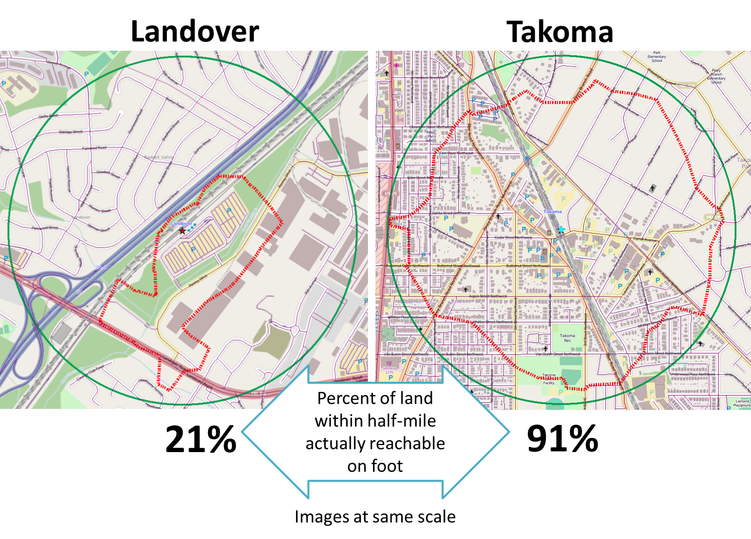
But why do we care so much about walk sheds? Because larger walk sheds mean more households in the walk shed, and that means ridership. For example, we’d be hard pressed to find many households in Landover’s small walk shed, so it’s no surprise that walk ridership at that station is low. On the other hand, thousands of households are within a reasonable walk to Takoma’s larger walk shed, and walk ridership there is much higher.
In other words, the more people can walk to transit, the more people do walk to transit – and data across Metrorail stations prove it:
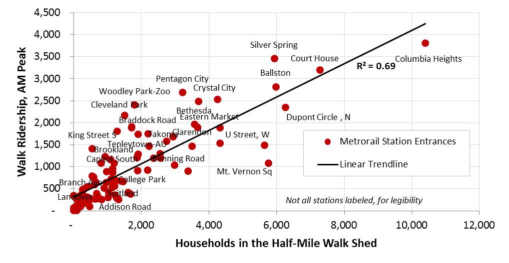
More households in the walkable area around a Metrorail station means higher ridership
The chart above shows that the number of households in a Metrorail station entrance’s walk shed is highly correlated with AM Peak walk ridership at that station. In fact, the number of households walkable to a Metrorail station alone explains nearly 70% of the variation in walk ridership across Metrorail stations.
This is a simple univariate correlation, but research currently underway at Metro will control for other factors using statistical techniques, and allow us to predict ridership as a result of households.
In part because walk access is so critical to ridership growth, our new Connecting Communities KPI (PDF) will evaluate how well the region adheres to its plans to promote the highest and best use of the land around Metrorail stations by growing and improving walk access to transit.

My guess is that the distance of walk sheds varies considerably with quality of environment. On a temperate day, a pleasant — i.e., safe, leafy, interesting things to look at, not too noisy — walk of a mile or more to Metro is nothing like too far.
Isn’t this a pretty good argument for ensuring we have two entrances at as many stations as possible? Foggy Bottom, Courthouse, Columbia Heights, Petworth all could really unlock a lot more potential with second entrances.
@LowHeadways: This information can be part of the conversation, along with the capacity of the station to handle current and future loads (escalators, fairgates, etc.) and funding priorities. Part of why we are doing this analysis is to show the relationship between growth around stations and future ridership so we can identify crowding issues and potential capital needs before problems arise.
For the “urban” stations like Columbia Heights, Dupont, and Mt. Vernon Sq, probably the reason they are below the trend line is that many people within the walkshed take the bus rather than Metro.
I notice you have “U Street W” which says to me that you have broken up the two entrances. Are the walksheds for each entrance calculated separately in terms of which entrance is closer? Otherwise, if you have the entrances each with their own 1/2 mile walkshed you will have people who are not counted in “walk ridership” who are walking to Metro but are using the other entrance.
It would be very interesting to have the background information for this post – walkshed images and the excel file with data.
Very interesting. From reading through the document on the KPI, I’m impressed with how its laid out & that y’all are also working to include an accurate jobs component as well.
One more thing to consider for annual reporting would be updates to the pedestrian network. Land use changes slowly in aggregate, even if a lot of development is in the pipeline. Pathways that bring additional job sites or residences into station walksheds can do just as much to “connect communities.”
A table listing the numbers (# of households vs walk ridership) for all stations would be helpful, since due to clustering, most stations are not labeled on that chart.
@Vinnie The next round of work on the KPI will illustrate three ways a jurisdiction can impact their score: Add more households in the walkshed, add new transit, and increase the size of the walkshed. This third one is where the ped paths come into play.
@Matt Dickens Mt. Vernon has been puzzling me. Its walk ridership underperforms given the number of households in its walk sheds. Could it be that folks around Mt. Vernon Square are walking all the way to downtown, or perhaps to McPherson?
P.S. Also, see my comment on this post for how we split walk sheds by entrance at some stations, but not all.
@Justin Yep, as a resident nearest to Mt V Metro I’d say that’s quite likely to be it, and @Matt Dickens is right-on in saying that those more downtown stations likely see less rail ridership simply because bus (and more critically, I’ll add walking+biking) are more convenient options. Mt V Square, in particular, is well covered by both N-S as well as E-W bus routes that can get us to most of the city in about 15-20 minutes, is blanketed by Bikeshare and bike lanes, and is a short walk to many of the employment centers.
Great Discussion on walk sheds. I think your Landover Station is a good example. While there is virtually no current walk shed. There could be a vibrant Mixed Use community developed there and recent planning document (Route 202 Plan & Sub Region 4 Plan) call for just such development in the future.
Unfortunately, WMATA has chosen this location for a Maintenance rail yard which will certainly discourage Mixed Use development. So how do we get WMATA to encourage development in walk sheds instead of discouraging it?
A lot of good stuff has been discussed here already. Somewhat following the earlier posts, I wonder how much built environment and land uses (street networks, amenities, shops, restaurants, cafes, etc.) affect the size of walkshed. It is well-know in the transit research literature that people perceive time to wait for a next bus or train less burdensome when they can use that time productively–reading a book, checking important emails, buying groceries from a store, etc. In suburbs in the Tokyo Metropolitan areas, many stations have commercial establishments in close proximity, which becomes a place to “stop by” on the way to and from home. This could reduce “walking distance” that is perceived by people to “have to walk” to get to a station–in other words, reducing the burden of walking.