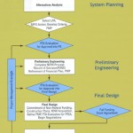
With increasing fuel prices and a rebounding economy soon to increase transit demand and with the progress of the Metro’s Regional Transit System Plan, it is opportune to reflect on the time and effort necessary to develop and implement a new rail line, be it Metrorail, light rail or streetcar. An important time factor is the Federal procedures and evaluations for Federal funding, upon which most ‘major capital investments’ in rail transit are reliant. The Federal share can range from 30 to 50 percent of the total project cost. The two most recent Metrorail extensions – Blue Line to Largo Town Center and the Dulles Corridor Line to Wiehle Avenue Station – follow or exceed the experience across the nation of 10 to 12 years from start of alternatives analysis (AA) to start of revenue operations. The Maryland Transit Administration conducted the AA of the Blue Line extension in the early 1990s; the 3-mile extension opened in late 2004. The Virginia Department of Rail and Public Transportation conducted the AA (then, a Major Investment Study, MIS) of the Dulles Corridor extension in the mid-1990’s; the 11-mile extension to the Wiehle Avenue Station will open in late 2013, nearly twenty years later.
For both these heavy rail extensions and for the light rail and streetcar projects now under development, the original project delivery schedules were more compressed. For example, the Dulles Corridor Task Force recommended in 1999 that the Dulles Corridor extension be open through Tysons Corner by 2006. An explanation for the differences in original and actual schedules includes, but is not limited to, extended timeframes for the following:
Read more…
Metro is trying to triple the number of bicyclists accessing our transit services by 2020. Our Bicycle & Pedestrian Access Improvements Study showed that although bicycling represents a small portion of station access now, this mode has very strong potential for growth. For example, many of our parking customers live less than 3 miles from their rail station, and many parking facilities fill up between 7:45 and 8:30 am.

As part of this campaign, we are trying to learn more about the travel patterns of bicyclists so that we can better plan facilities and services for them. For example, how strong is the “seasonal” effect in biking? What time of day do cyclists ride? How does bicycling demand patterns compare to our rail and bus networks?
One source of data for these questions is the automatic bicycle counters that Arlington County has installed on the Custis Trail, a major trail for bicyclists between downtown, Arlington, and points west. This counter can sense the difference between a bicyclist and a pedestrian, and has been silently counting both since October 2009. The counter is located at the top of the hill between Rosslyn and Courthouse (map). Previous analyses of this data are available online.
While Custis Trail users certainly don’t necessarily represent current or potential bike-to-rail customers, they do provide some data-driven insight into the travel demand of bicyclists, whom we hope will be a key part to Metro’s long-term strategies for rail access. So, the rest of this post analyzes bicycle counts by 15-minute intervals between October 2009 and February 2011.
Read more…

Accessing secure bike parking with third-party equipment at Tri-Met. Photo courtesy of KTesh (click for original context)
Back in January, we asked for your opinions on how bicyclists could pay and get access to a pilot secure bicycle parking facility at College Park station. Thanks to you all for your great feedback. Planning for the project is actively underway, and we wanted to give a quick update.
Survey Says… The results from the (admittedly non-scientific) survey showed:
- A willingness to pay some small amount for the improved service
- Strong support for using your existing SmarTrip card
- A moderate preference for pay-per-use fees, rather than annual fees Read more…
The Washington Metropolitan Area Transit Authority (WMATA) seeks energetic individuals to join its Department of Planning and Joint Development to advance the Authority’s vision of improved and expanded public transit services.
The Senior Planner position manages and conducts transit systems planning analyses, transit facility and corridor improvement projects, and other transportation planning studies. In addition, the Senior Planner participates in regional planning activities that include coordination with federal, state, regional, and local agency representatives and other stakeholders. This is a highly responsible professional position involving technical planning, project management and advocacy work of a complex nature.
Candidates for the Senior Planner (ref.# 110295) should have experience with and knowledge of regional and corridor planning, transit project development, systems planning studies, quantitative analysis, and project management. For more details or to submit an application online, visit http://www.wmata.com/careers/metro_jobs/
Closing date is April 29, 2011.
 In 1997, the WMATA Board of Directors appointed the Regional Mobility Panel. Made up of members from regional governments as well as business, labor and citizen leaders, the panel was charged with reducing costs and increasing integration of the region’s bus services. In addition to publishing Principles for Coordinated Bus Service in the Washington Metropolitan Area, the panel also identified the need for service planning processes and procedures. The panel recommended service criteria be developed to allow evaluation of regional bus service provided by WMATA. (Regional routes cross jurisdictional lines and are subsidized by all compact jurisdictions.) In consultation with the local jurisdictions the following criteria were developed and integrated into Metrobus Service Adjustment Policies, adopted by the WMATA Board of Directors in February, 2000.
While the criteria were established to evaluate productivity of regional routes, Metro also evaluates non-regional routes the same way. However, routes of a given service type (regional vs. non-regional) are evaluated against average performance criteria of only its own service type. These critical values are calculated annually based on past years’ performance.
- Daily Weekday Passenger Boardings
- Cost Recovery
- Average Subsidy Per Passenger
- Passengers Per Revenue Trip
- Passengers Per Revenue Mile
For a more detailed description of these criteria, please see the Metrobus Service Guidelines document.
Report of the Regional Mobility Panel, 1997 (PDF, 1 MB)

Image from Downtown DC BID
In our discussions about the costs of Metro, it’s worth stepping back and considering the regional benefits our transit system provides – beyond simply another way to get from Point A to Point B. Against a backdrop of funding needs, a crucial question is, “how does the region benefit from continued funding of Metro?”
Since the WMATA Compact was signed in 1967, we have built a 106-mile heavy rail network, the bus and paratransit systems now cover 1,500 square miles, and together we make around 1.2 million trips on the system every day. Our choice to build and use transit has had broad impacts on the region: it has changed the way land is developed, where businesses choose to locate, how the economy grows, how families get around and settle in livable neighborhoods, how we impact the environment, and more. Read more…
February 22nd, 2011
Wendy
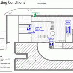
In October, we published a post about the ongoing Union Station Metrorail Access and Capacity Study, and included a pedestrian simulation showing the existing conditions at the Union Station Metrorail station’s north mezzanine. The study has been completed, and the proposed access and capacity improvements and resultant station performance are described below
Currently, passengers traveling through the north mezzanine experience congestion on a daily basis. Imagine what would happen at the north mezzanine in the next 20 years, once Union Station’s local and intercity travel facilities have been expanded (including the planned streetcar terminating at 1st and H Streets NE) and the millions of square feet of planned development in the surrounding areas have been completed. Our analysis shows that pedestrian volume through the north mezzanine will increase by 60%.
The biggest challenge faced by Metro during this study was to identify feasible improvements that would provide enough capacity for all users while ensuring compatibility with building functions and historical characteristics. Metro worked with DDOT and Union Station stakeholders to develop two improvement alternatives: Partial Build and Full Build. These alternatives are illustrated in the animated graphic below, which rotates between existing conditions, partial build and full build every 15 seconds. Read more…

Embedded sensor, currently being tested at Fort Totten Kiss and Ride metered parking spaces.
One of the challenges Metro faces is how to best support Parking customers. Good data on parking space utilization at metered Kiss and Ride spaces can be hard to come by and finding a metered parking space at many stations can involve guesswork. To address this lack of space availability information, Metro is beginning a 1-year pilot of sensors in parking spaces at the Fort Totten Metro Kiss and Ride parking lot to capture data on space availability and usage and to facilitate payment. These battery-powered sensors will be mounted flush with the pavement in each parking space, and communicate information on availability and usage. These space sensors will last 5-7 years on their internal batteries, and provide nearly real-time information. Read more…

Secure bike parking at TriMet Sunset Transit Center. Image from TriMet, click for original context.
Metro would like to pilot a secure bicycle parking facility at College Park station, and we want your feedback on some of the particulars related to its operation – namely, how bicyclists should access this “bike garage,” and what it should cost. We want this pilot project to teach us the ins-and-outs for building more similar facilities in the future.
Why are you building secure bike parking? Because we want you to feel safe leaving your bike at a Metro station, and sometimes our existing racks and lockers aren’t sufficient. This is a top request from our riders – since bikes are not allowed on-board trains at busy times, you need a safe place to leave your bike. Also, bike parking is a very cost-effective way for us to give you access to the station, especially compared to the cost of auto parking. Read more…

Metro’s website has a new Bike and Ride section! The rules haven’t changed, but we’ve tried to make our policy about bicycles on Metrorail and Metrobus more clear, and to put the most frequently-requested items on the main page. Hopefully this will reduce confusion and encourage bicyclists! All the nitty-gritty details about bikes and transit are still there, of course.
What do you think of the changes? Let us know in the comments below.


Recent Comments