July 15, 2010
 The planning process for the RTSP has been an iterative one which allows for the exchange of information and feedback from the TAG members. The fourth meeting of the TAG included a review of the model results of the Base Case or Max CLRP and these strategies: New North-South Yellow Line on 10th Street, SW/NW; and a New North-South Yellow Line on 2nd Street, SE/NE. The results of these model runs showed the impact of each of these strategies on the passengers per rail car during the peak hour and the impact of rail inter-lining at key rail transfer points like L’Enfant Plaza, Rosslyn and Metro Center. These strategies address the need to increase core rail system capacity, one of the goals of the RTSP.
TAG Meeting 4 Presentation (3MB, PDF)
In 1967, the Washington Metropolitan Area Transit Authority was created under a 1966 interstate compact encompassing the District of Columbia and portions of the State of Maryland and Commonwealth of Virginia, for the purpose of planning, financing, constructing, and operating a comprehensive mass transit system for the Washington Metropolitan Region. According to Article VI of the Compact the Board shall develop and adopt, and may from time to time review and revise, a mass transit plan for the immediate and long-range needs of the compact region.

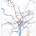
An early plan of the Metrorail system, from the online exhibit, Building the Washington Metro.
The Compact guided the development of the original Adopted Regional System (ARS) in 1968, designed to serve the region as forecast for 1990. Zachary M. Schrag, author of The Great Society Subway, hosts a website including maps and photos of the ARS, as well as an historical account of the building of Metrorail. As planning and engineering continued over the next 20-plus years, the ARS was reviewed and revised, consistent with the Compact. By the mid-1990s, planning had been completed for the ARS. Metro began to look at transit needs beyond those for which the original system had been planned, and to look at a much larger region, as forecast for 2025. Metro’s latest long-range system plan — the Transit Service Expansion Plan— was adopted in 1999.
Read more…
As Metro plans for the future, expecting ridership to increase from a current average of about 750,000 trips per day to more than 1 million, the question of how so many new passengers will access our system is a critical one. Our most recent passenger survey estimates that about 39% of our riders arrive by car – either parking or being dropped off; 33% walk to our system; 22% take a bus; 4% by commuter rail and <1% arrive on bike. Accommodating those new riders with the same modal split as we see today could be quite costly for the region. Therefore, Metro decided to take a look at where we could improve our mode share for those modes that require fewer financial resources – namely bicycling and walking. In 2009, we began a study that would provide a framework to help us achieve these higher shares.
Our Metrorail Bicycle and Pedestrian Access Improvements Study has identified strategies that will enhance bicycle and pedestrian access and connectivity in and around Metrorail stations. It provides recommendations for a range of physical infrastructure improvements, as well as policies and programs to encourage more walk and bike trips to stations. These recommendations fall into two main categories – those that Metro can implement alone, and those that require coordination with local partners.
Read more…


Recent Comments