Will the regional transit system be up to the challenge of meeting the Transportation Planning Board (TPB) Vision’s objectives and the Greater Washington 2050 Coalition Region Forward’s targets, especially for a higher transit mode share in 2040?
Image from mwcog.org
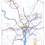
In early 2010, the Metropolitan Washington Council of Governments endorsed Region Forward. It includes goals, objectives and targets for the metropolitan area in 2050, relating to accessibility, sustainability, prosperity and livability. Transportation is one of nine categories among its goals, and the transportation targets draw heavily from the TPB Vision that was adopted in 1998. The Regional Transit System Plan (RTSP) is intended to help develop strategies to achieve Region Forward’s goals, objectives and targets. Several of these targets are focused on transit, and are compatible with the goals of the RTSP. What follows is a listing of Region Forward’s transit-focused goals, and how a future including an implemented RTSP may help achieve them.
Priority for management, performance, maintenance, and safety
This target echoes an objective in the TPB Vision and is intended to insure that investment in existing transportation infrastructure continues as a top priority. For example, Virginia’s funding for roads follows this philosophy, by funding road maintenance and operations off the top of revenues. That philosophy would be advantageous for transit, too, so that investments in new infrastructure wouldn’t result in disinvestment in the existing bus and rail infrastructure that continues to be needed.
RTSP is evaluating an “Enhanced Surface Transit” strategy, in which the network of 24 Metrobus Priority Corridors (PCN’s) are enhanced with bus priority treatments, intended to increase performance of surface transit service in the region while reducing overall operating costs. The RTSP will also look into new surface transit connections with an eye towards interoperability, which would help reduce costs of managing and maintaining different new light rail and streetcar systems. Read more…
Embedded sensor, currently being tested at Fort Totten Kiss and Ride metered parking spaces.
One of the challenges Metro faces is how to best support Parking customers. Good data on parking space utilization at metered Kiss and Ride spaces can be hard to come by and finding a metered parking space at many stations can involve guesswork. To address this lack of space availability information, Metro is beginning a 1-year pilot of sensors in parking spaces at the Fort Totten Metro Kiss and Ride parking lot to capture data on space availability and usage and to facilitate payment. These battery-powered sensors will be mounted flush with the pavement in each parking space, and communicate information on availability and usage. These space sensors will last 5-7 years on their internal batteries, and provide nearly real-time information. Read more…
As Metro plans for the future, expecting ridership to increase from a current average of about 750,000 trips per day to more than 1 million, the question of how so many new passengers will access our system is a critical one. Our most recent passenger survey estimates that about 39% of our riders arrive by car – either parking or being dropped off; 33% walk to our system; 22% take a bus; 4% by commuter rail and <1% arrive on bike. Accommodating those new riders with the same modal split as we see today could be quite costly for the region. Therefore, Metro decided to take a look at where we could improve our mode share for those modes that require fewer financial resources – namely bicycling and walking. In 2009, we began a study that would provide a framework to help us achieve these higher shares.
Our Metrorail Bicycle and Pedestrian Access Improvements Study has identified strategies that will enhance bicycle and pedestrian access and connectivity in and around Metrorail stations. It provides recommendations for a range of physical infrastructure improvements, as well as policies and programs to encourage more walk and bike trips to stations. These recommendations fall into two main categories – those that Metro can implement alone, and those that require coordination with local partners. Read more…
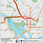
More than two-thirds of daily ridership occurs during the morning and evening peak periods. In fact, the peak ridership is a key determinant to Metro’s operating plan and future system planning efforts. An assessment of peak passenger ridership allows Metro to locate areas of current and future peak-period passenger crowding, and then plan to develop and fund capital projects aimed at addressing these capacity-constrained locations.
In 2009, Metro’s Office of Long Range Planning developed a tool to estimate passenger ridership on individual rail segments based on the station-to-station origin-destination data in the ridership database. The tool approximates passenger volume by peak hour and period. Then we use GIS to map the link-level passenger volumes.
The Metrorail Station at Union Station is the busiest station in the Metrorail system, with 70,000 passengers entering and exiting daily. This station has experienced substantial ridership growth in the past three decades from the development of surrounding DC neighborhoods, expanded intercity travel and commuter rail’s growing popularity. The existing station, designed in the 70s, can no longer accommodate the current and future passenger travel. Passengers experience congestion on a daily basis.
In late 2009, Metro, in collaboration with the District Department of Transportation (DDOT), initiated a Union Station Capacity and Access Improvements Study. The objective is to assess capacity deficiencies and develop alternatives to enhance pedestrian access, increase station capacity, reduce travel time and improve connectivity to the other transportation modes. To be able to compare the benefits of the proposed alternatives, Metro used a pedestrian simulation tool, developed by Legion, to quantify and assess the performance throughout the station’s north mezzanine under the current station conditions and with the proposed capacity improvements. We’ve put this post up so people can see the kinds of analysis tools Metro is using to evaluate station capacity and to visualize capacity and operating issues. Metro will be using the pedestrian simulation tool and analysis at other stations experiencing crowded conditions, such as the Gallery Place-Chinatown station.


Recent Comments