Solving the Region’s Congestion Woes – One Step at a Time (Part 3 of 3)
Making every Metrorail station area walkable could reduce regional congestion without breaking the bank.
This is part three of a three-part series.
In the previous two posts we’ve laid out a case for making all transit stations walkable as quickly as possible.
- Increasing walkability and density at station areas has huge impacts on transit mode share and can take tens of thousands of cars of the road every single day.
- At a regional level, walkable station areas have an equivalent impact on congestion as a quarter trillion dollars in “last mile” infrastructure (see pages 37, 38, 43, 48).
Maximizing the capacity of the existing transit network while intelligently investing in station area connectivity would combat regional congestion just as effectively as trying to “build our way out of the problem”. And unlike many potential interventions, the market actually wants to do this for us.
Perhaps it is time to harness these market forces to make the areas around our transit network walkable and implement this low-cost congestion-busting paradigm. As for where to begin – well, we have a few suggestions…
Existing Walkability Near Metrorail Stations
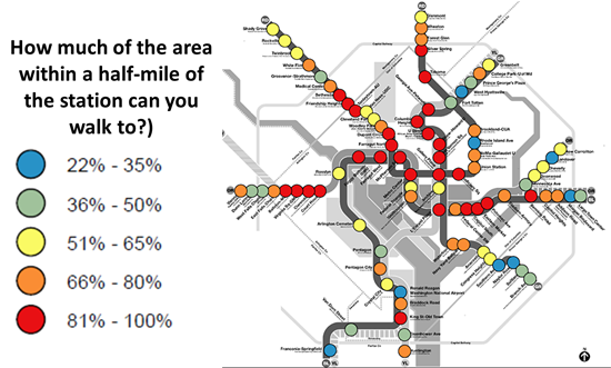
The map below shows the range of existing walkability conditions near the Metrorail network and helps answer the question of how much of a half-mile radius of each station a person can walk to. The higher the percentage, the better the pedestrian network coverage. As shown, many of the station areas are under performing relative to their potential walkability. If walkability = connectivity and connectivity = mode share, then just imagine the impact on the region’s roads if we could focus on taking station areas with low accessibility and invest in some relatively easy, short-term solutions like sidewalks, pedestrian bridges, crosswalks, and smart, transit-oriented development to take maximum advantage of the existing Metrorail system and take tens of thousands of cars off the road each day.


Recent Comments