Posts Tagged ‘pedestrian’

Pedestrian Paths and Bike Stairchannel Complete at Glenmont

November 15th, 2013 9 comments

As we continue to improve pedestrian and bicycle access to Metrorail,  Metro has recently completed several  improvements on the east side of Glenmont station.

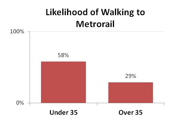
Walking and bicycling are key access strategies for Metrorail, as Metro seeks to grow ridership in sustainable and cost-effective ways. As our studies have shown, accommodating new riders at our current access modal shares would be quite costly to the region.  At Glenmont station, around 12% of riders in the morning arrive on foot or by bike, but there may be growth potential. Nearly 80 customers per day live within 1 mile of the station but currently park.  Over 550 customers, or a third of all parking customers, live within 3 miles of the station but currently park.

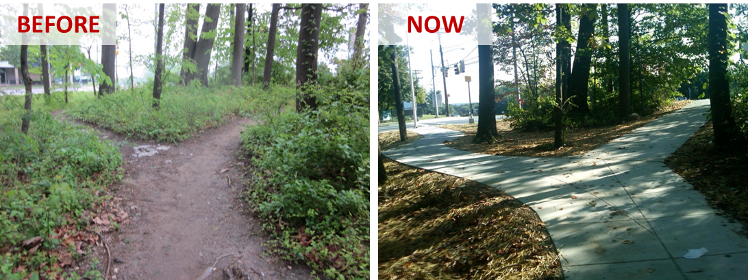
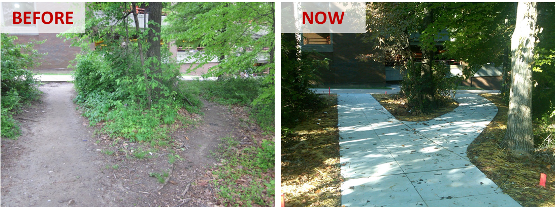
To make Glenmont station more attractive and safe for pedestrians and bicycles, Metro’s Parking Office has constructed new paved pathways connecting the station to the intersection of Layhill Road and Glenallan Avenue, replacing a dirt path. Metro has completed this work as part of the Bicycle and Pedestrian Capital Improvement Program.

Glenmont NE Path 3Glenmont NE Path 2

Read more…

moveDC Public Workshop Announcement – Comment on DC’s long-range transporation plan!

October 18th, 2013 Comments off

moveDCThe District Department of Transportation (DDOT) is hosting its third and final round of public workshops in October to discuss moveDC, DDOT’s initiative to develop a strategic, multimodal long range transportation plan for the District.  The public is encouraged to attend a workshop to review the draft plan and help prioritize the transportation options. The October workshops will enable you to:

  • Share your ideas and observations on future plans for transportation;
  • Learn how three approaches to a future DC transportation system perform;
  • Review the results of our survey research;
  • Provide input into the draft transportation plan; and
  • Learn more about the moveDC local bus study.

Online Survey

Throughout October, you are also invited to participate in a survey to comment on and critique three approaches that have the potential to transform the way people travel in the District.

Public Meeting Dates and Locations

Monday, October 21

7:00 a.m. to 6:00 p.m.

Union Station

625 First St NE

Tuesday, October 22

6:30 p.m. – 8:30 p.m., with a formal presentation 7 p.m.

Dorothy I. Height/Benning Neighborhood Library

3935 Benning Road, NE

Saturday, October 26

1:00 p.m. – 4:00 p.m.

DCUSA Retail Center, 2nd Floor, between Target and Best Buy

3100 14th St. NW

Wednesday, October 30

6:30 p.m. – 8:30 p.m., with a formal presentation 7 p.m.

Petworth Neighborhood Library

4200 Kansas Ave., NW

Web Meetings

Visit www.wemoveDC.org for more details and to sign up.

October 24, noon – 1:00 p.m.

October 28, 7:00 p.m. – 8:00 p.m.


Delivering the Transit System the Region Needs

August 6th, 2013 Comments off

Delivering the transit system that Columbia-Heights-Sta-041007-018the region needs will require an unequivocal commitment of additional resources from internal and external stakeholders. Simply put, the rehabilitation work being accomplished at the time of the writing of this document will not be nearly enough to keep up with the region’s needs, and without additional resources it will be unlikely that the region can continue to enjoy a transit network that contributes to competitiveness and makes the Washington metropolitan area one of the most desirable places to live and work.

Metro – Doing Business Differently

Metro recognizes that rebuilding the region’s transit system also means rebuilding the region’s transit authority – and will continue to be hard at work on this task in preparation for the implementation of Momentum.  In the near term this means revamping nuts and bolts elements of the authority, including but not limited to: identifying ways that Metro can do its job more efficiently while increasing performance; evaluating its contracting and procurement philosophy to emphasize lifecycle contract and asset management; engineering a budgeting process that allows Departments to strive to achieve the goals of Momentum within the context of tight fiscal and financial discipline; and a human capital strategy that must have the right talent in-place and in-queue.  In the long term, this means completing the journey to a much more business-like operating and execution philosophy for the organization.

Read more…

Time for Those Walking Shoes, Part 2

August 1st, 2013 5 comments

Walk access to Metrorail has increased 15% over the last 5 years, especially from those living within a half-mile of the station.  

So more rail riders are choosing to walk to their Metrorail station, according to the 2012 Metrorail Passenger Survey. But who are these pedestrians?

Around 40% of Metrorail customers in the AM peak walk to the station.  The survey found that younger people are much more likely to walk, with those under 35 were nearly twice as likely to walk to the train as those over 35:

Walk_Access_to_Metrorail_2012_by_OverUnder35However, younger Metrorail riders are also more likely to live within walking distance of their Metrorail station. Half of all riders under 35 live within a half-mile Metrorail, while 22% of those over 35 do.  Younger people in our region generally are slightly more likely to live near Metrorail –  15% of everyone under 35 in the region lives within a half-mile of Metrorail, 12% for those over 35. The chart below shows how younger riders tend to live closer to Metrorail: Read more…

Time for Those Walking Shoes, Part 1

July 30th, 2013 7 comments

Walk access to Metrorail has increased 15% over the last 5 years, especially from those living within a half-mile of the station.  

More and more Metrorail riders are lacing up their walking shoes and taking a short walk to their rail station these days.  According to results from the 2012 Metrorail Passenger Survey,  the number of passengers walking to Metrorail each morning grew by 15% between 2007 and 2012, from 78,500 to 89,900 in the AM peak period – far outpacing overall growth in ridership in the same period.

Where are all the new pedestrians coming from?  From stations all over the network, but the growth is strongest among those walking a half-mile or less.  Those walking from less than a half-mile rose by over 20% – faster than the overall growth in walk access.

Walk access to Metrorail has increased 15% over the last 5 years, especially from pedestrians walking a half-mile or less.

Walk access to Metrorail has increased 15% over the last 5 years, especially from those living within a half-mile of the station.

Read more…

Categories: Engage Tags: , , , ,

Huntington Station Auto Access “Hotspots”

July 25th, 2013 2 comments

Heat map showing parking access within 1 mile and 3 miles at Huntington station, which may indicate good opportunities for pedestrian and bicycle improvements  (click for full map)

Heat map showing parking access within 1 mile and 3 miles at Huntington station, which may indicate good opportunities for pedestrian and bicycle improvements (click for full map)

We continue to explore barriers to pedestrian and bicycle access to Metrorail stations with a look at Huntington station. Previous posts in this series explored Forest Glen and Southern Avenue stations.  All stations profiled share similar characteristics in that they have a high percentage of short-distance (less than three miles) parking access, and low bicycle use.  By looking at street layout, customer distribution and gathering your comments we are working to better understand barriers facing pedestrians and bicyclists and improve safety.

The map on the right (full version) shows auto access “hotspots” for Huntington station. Huntington is located in Alexandria Virginia less than a mile south of interstate 495, the Capital Beltway.

The station serves as a park and ride option for commuters from south of the DC metropolitan area as it is the last station on the southern end of the Yellow Line and is easily accessible from the interstate. Still, roughly half of the 3,600 daily parking customers originate from the many residential areas within three miles of the station.

Short distance parking customers almost exclusively originate from south and west of the station. The Potomac River, Capital Beltway, and proximity to Eisenhower Ave, Kings Street, and Braddock Road stations also along the Yellow Line seem to influence this. Read more…

Southern Ave Station Auto Access “Hotspots”

May 13th, 2013 8 comments

Heat map showing short-distance parking access at Forest Glen station, which will be incorporated into the next rail to bike planning effort (click for full map)

Heat map showing parking access within 1 mile and 3 miles at Southern Ave. station, which may indicate good opportunities for pedestrian and bicycle improvements  (click for full map)

Last December we looked at the Forest Glen station and asked you for insights on why people coming from so close (less than three miles) would drive to the station. In the upcoming weeks we are taking a look at five additional stations that also have a high percent of short-distance parking access and low bicycle use: Southern Ave, Glenmont, Largo Town Center, and Grosvenor-Strathmore. For each, we will explore the station’s local conditions and we ask you to share your insights about what can be done to improve walking and biking access to these stations.

The map on the right (full version) shows auto access “hotspots” around Southern Ave station. The Southern Ave station is located just southeast of the boundary between the District of Columbia and Prince George’s County.

Many residential neighborhoods are located within the three-mile radius of the station, and a large concentration of parking users residing within one mile of the station.

However, many possible barriers could inhibit non-motorized travel to Metro:

  • Southern Ave SE is a fast-moving, four-lane road that is uninviting to pedestrians, despite traffic signals, sidewalks and streetlights.
    • WalkScore.com gives the Southern Ave Metrorail station a walk score of 52 out of a possible 100.
  • The station has no direct connectivity to the surrounding residential neighborhoods.  All access to the station must occur via Southern Ave SE.  As such, many neighbors of the station must travel long and circuitous routes to access Metrorail.  See the image below.
  • The station nestled into a corner of Oxon Run Park, further limiting station access routes for nearby residents.

Read more…

Chart of the Week: “Hotspots” for Pedestrian and Bike Access to Rail Stations

December 17th, 2012 11 comments

Heat map showing short-distance parking access at Forest Glen station, which indicates good opportunities for pedestrian and bicycle access (click for full map)

In our effort to improve safety, access and sustainability, Metro is expanding our understanding of bike and pedestrian barriers faced in commuting to our Metrorail stations. Over the past several years, we have focused our bike and pedestrian project planning and implementation efforts on improvements we can make to our station areas such as, installing bike racks or constructing pedestrian improvements. Now, we’d like to expand the envelope and develop a list of access needs beyond our own boundaries and work with our jurisdictional partners to make needed improvements.

One way we are doing this is by gaining a better understanding of where auto commuters come from when they drive to our stations, and zeroing in on areas where we see a good deal of auto access to determine if there are barriers to walking or biking to the station.

The map at right (full version) shows auto-to-station “hot spots” around the Forest Glen station, to pick one example, locations from which clusters of customers drive and park at Metro. According to the 2007 Metrorail Passenger Survey data, many customers drive from within a 1-3 mile radius; some are even closer. So why are so many people from this area driving? In our 2010 Bicycle and Pedestrian Master Plan, we teased out some of the more broad-based reasons why people drive rather than walk or bike – now we’d like to explore each station’s local conditions and see what can be done to improve walk and bike access.

The Forest Glen station is located north of the Capital Beltway and west of Georgia Avenue. More commuters to Forest Glen are from north of the Beltway and east of Georgia Avenue. There is pedestrian overpass over the Capital Beltway which helps facilitate foot traffic:  Is crossing Georgia Ave then a barrier?  There are four Metro rail stations located within a 2-mile radius of Forest Glen which draw away commuters farther from the station. This could help to explain the highly localized nature of the parking shed.

There are many factors not considered here such as demographics, bus usage, and average driving trends. Further research into parking and commuting trends is in the works.

If you commute from this area, can you comment about what you experience on your commute? Do you drive?  If so, what factors influence you to drive instead of walk or bike? Would you like to walk or bike, but the infrastructure isn’t there or the traffic is too daunting? Or do you see something else from this data? We want to hear from you and appreciate any feedback you have that can make our system more accessible to pedestrians and cyclists.

Brookland Pedestrian Improvements

August 31st, 2012 3 comments

Metro has constructed several pedestrian improvements on the east side of Brookland-CUA station to create a safer and more pleasant pedestrian experience.The majority of the work was improving the connection from the station entrance to Bunker Hill Rd. NE  (map), which had previously been a dirt path.  We installed new stairs and an accessible ramp to Bunker Hill Rd. NE, and added sidewalks and curb ramps along the road, up to the intersection with 9th St. NE.  In addition, we made improvements to several crosswalks and curb ramps near the bus loop. We undertook this work as part of Metro’s Pedestrian and Bicycle Element of 2012-2017 Capital Improvement Program.  Pictures below:

New staircase and ramp replace former dirt path at Brookland-CUA station

New sidewalk and curb ramps replace former dirt path

New sidewalk to access intersection of Bunker Hill Rd. NE and 9th St. NE

As some eagle-eyed spotters have noticed, we are also working on installing new bike racks on the west side of Brookland-CUA station, near the Met Branch Trail. However, the installed racks were not quite up to our standard, so we have instructed our contractor to replace them and they should be complete shortly.

Categories: Planning Studies Tags: ,

New Pedestrian Paths at College Park Station

June 6th, 2012 3 comments

In conjunction with the Bike & Ride facility, Metro recently constructed multiple sidewalks on the east side of College Park – U of MD station to provide easier and safer pedestrian and bicycle access to the station and the Bike & Ride.  One of the sidewalks provides direct access to Paint Branch Parkway which leads to the Northeast Branch Trail less than ½ mile away.  In addition to the sidewalks, we installed curb ramps to meet ADA standards, and established a safer pedestrian route across the bus loop to the station entrance.

We undertook this work as part of Metro’s Pedestrian and Bicycle Element of 2012-2017 Capital Improvement Program.  We will be making bike, pedestrian, ADA and sidewalk improvements next at Cheverly, Landover, New Carrollton, Glenmont, Shady Grove, Brookland-CUA, Huntington, W. Falls Church, Vienna and Van Dorn.  What key bike and pedestrian connections at stations do you recommend be made?

Before and after pictures are shown below:

New pedestrian and bicycle improvements at College Park station.