To improve the effectiveness and reliability of bus service, WMATA and DDOT recently initiated an operational analysis to explore bus-only lanes along H and I Streets NW, one of the busiest bus corridors in downtown Washington, DC. The study team recently completed the existing corridor conditions assessment and applied VisSim, a multi-modal traffic simulation tool, to identify and quantify the congestion impacts on buses as well as other roadway users, including pedestrians, bicyclists and private vehicles.
In October, we published a post about the ongoing Union Station Metrorail Access and Capacity Study, and included a pedestrian simulation showing the existing conditions at the Union Station Metrorail station’s north mezzanine. The study has been completed, and the proposed access and capacity improvements and resultant station performance are described below
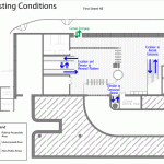
Currently, passengers traveling through the north mezzanine experience congestion on a daily basis. Imagine what would happen at the north mezzanine in the next 20 years, once Union Station’s local and intercity travel facilities have been expanded (including the planned streetcar terminating at 1st and H Streets NE) and the millions of square feet of planned development in the surrounding areas have been completed. Our analysis shows that pedestrian volume through the north mezzanine will increase by 60%.
The biggest challenge faced by Metro during this study was to identify feasible improvements that would provide enough capacity for all users while ensuring compatibility with building functions and historical characteristics. Metro worked with DDOT and Union Station stakeholders to develop two improvement alternatives: Partial Build and Full Build. These alternatives are illustrated in the animated graphic below, which rotates between existing conditions, partial build and full build every 15 seconds. Read more…
The Metrorail Station at Union Station is the busiest station in the Metrorail system, with 70,000 passengers entering and exiting daily. This station has experienced substantial ridership growth in the past three decades from the development of surrounding DC neighborhoods, expanded intercity travel and commuter rail’s growing popularity. The existing station, designed in the 70s, can no longer accommodate the current and future passenger travel. Passengers experience congestion on a daily basis.
In late 2009, Metro, in collaboration with the District Department of Transportation (DDOT), initiated a Union Station Capacity and Access Improvements Study. The objective is to assess capacity deficiencies and develop alternatives to enhance pedestrian access, increase station capacity, reduce travel time and improve connectivity to the other transportation modes. To be able to compare the benefits of the proposed alternatives, Metro used a pedestrian simulation tool, developed by Legion, to quantify and assess the performance throughout the station’s north mezzanine under the current station conditions and with the proposed capacity improvements. We’ve put this post up so people can see the kinds of analysis tools Metro is using to evaluate station capacity and to visualize capacity and operating issues. Metro will be using the pedestrian simulation tool and analysis at other stations experiencing crowded conditions, such as the Gallery Place-Chinatown station.


Recent Comments