Identifying & Funding Pedestrian and Bicycle Project Needs
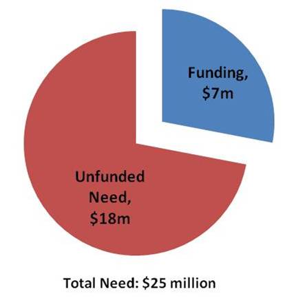
Back in August, we posted information about our latest endeavors to improve bike and walk access to Metrorail. We have since completed our field work and now have a laundry list of more than 3,000 individual projects throughout the Metrorail system that we identified through that effort. The projects range from the small and simple (e.g., Vienna racks) to the larger and more complex (e.g. additional Bike & Rides). Metro’s Pedestrian and Bicycle Element of 2012-2017 Capital Improvement Program (1.1 MB, PDF) summarizes the findings by category, and provides an overview of the methodologies we employed to prioritize projects, as we identified a larger need than is currently funded.
And, although the primary goal of this project is to provide a list of needed bike and pedestrian access projects to be funded through Metro’s Capital Improvement Program (CIP), the list of needs developed in the inventory also will help better inform our partnerships on transit oriented development (TOD) and other projects near our stations. Many of the projects improve the links from our station property to that of other property owners and will be instructive as stations undergo development transformations.
Project Highlights
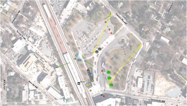
Field teams were out evaluating conditions all over the system. They highlighted desire lines to stations, bike parking needs, sidewalk & pathway improvements, intersection improvements and other pedestrian and bike needs. Below are some high level summaries to give you a flavor of what we found out there:
Sidewalks and paths: Our field work identified hundreds of small sidewalk and pathway projects typically on Metro property that will improve access to our stations. Each project tends to be small, say 200 to 500 feet long, but added together from end to end, they would stretch 10 miles. Most of these projects are at suburban stations, where our entrances tend not to be directly located on the street network.
Intersection improvements: We looked at the intersections that serve our stations for places where new crosswalks, curb ramps, crossing islands or other improvements were needed and found 700 locations for such improvements. Many of these are located off of our property on adjoining streets, so we plan to work with the local jurisdictions to address these.
Bike parking: More than 400 potential locations for future bike parking were identified, including the type and expected capacity of parking. The field survey explored potential locations for additional Bike & Ride parking facilities and covers for bike racks. Our plan is to build or reserve space for bike parking in the amounts needed to help us reach our mode share goals of 2.1% by 2020 and 3.5% by 2030. To make these numbers work, we’ll continue to work with our local bike/ped planning partners to improve the on- and off-street connections to our stations so we can fill this bike parking.
Prioritizing Projects
 So, 3000+ is a lot of projects. We’d love to be able to do them all. However, our funding is currently constrained. So, what do we do? – we prioritize. And, how do we do that? We look to our Agency goals. At the top of the list is safety & security, delivering quality service and using resources wisely. We took a look at how our projects stacked up against these goals and created an action plan to complete the projects that best achieved them. There are more details about the process in the attached document, but let it suffice to say we think we’ll make some real headway in meeting these goals and their accompanying objectives as we improve access to our stations. In the meantime, if other funding opportunities crop up – say TIGER IV, or V, or XXXII – we’ll be ready to go.
Follow Along with Us
We have already begun work on the projects identified, and planning for more projects is underway. As we complete projects we’ll continue to post them here. Please let us know what you think. Have they helped? Are there other projects you see out there?
Update January 18, 2012: Maps of all project needs at by individual Metrorail station are available below. Due to the size of the files, we’ve posted them as 8 separate documents in alphabetical order by station name. They should be readable with Adobe Acrobat 6.0 or later:
- Addison Road-Seat Pleasant to Capitol South (PDF, 2.2 MB)
- Cheverly to Dunn Loring-Merrifield (PDF, 2.2 MB)
- Dupont Circle to Gallery Pl-Chinatown (PDF, 2.5 MB)
- Georgia Ave-Petworth to King Street (PDF, 6.0 MB)
- Landover to Metro Center (PDF, 1.2 MB)
- Minnesota Ave to New York Ave-Florida Ave-Gallaudet U (PDF, 7.0 MB)
- Pentagon City to Twinbrook (PDF, 3.2 MB)
- U St/African-Amer Civil War Memorial/Cardozo to Woodley Park-Zoo/Adams Morgan (PDF, 2.4 MB)


Recent Comments