Implementation of the Current Long Range Plan
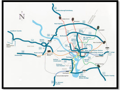
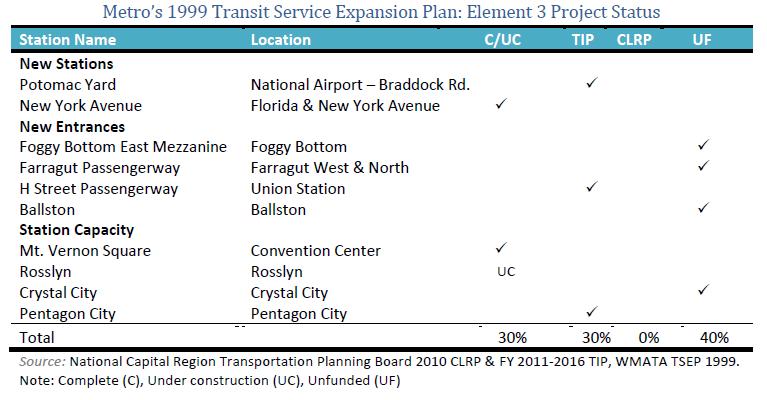
Metro’s Transit Service Expansion Plan (TSEP) of 1999 is comprised of four major elements that form the backbone of a regional transit system. This post is intended to highlight the status of projects implemented under the two elements of the plan that call for expansion of the region’s fixed-guideway transit system. The first involves selectively adding stations, entrances, and station capacity to the existing Metrorail system. Specifically, the plan calls for two new stations, four new station entrances, and expansion of station capacity at four existing stations. The second element of the Metro’s current plan that emphasizes system expansion focuses on the expansion of fixed-guideway systems – whether the mode is Metrorail, light-rail (LRT), other rail technology or busways.  The areas served by this element of the plan are illustrated on the map shown. Under this element, the goal is to provide for at least 50-percent expansion of the region’s fixed guideway systems over the 25-year planning horizon. Below are two tables that outline the status of the station and fixed-guideway projects in the plan.
How would you rate the implementation of the system expansion elements of the 1999 plan? Do you think the region is on-track to reach the goal to provide for at least 50-percent expansion of the region’s fixed guideway systems set in the 1999 plan? More importantly, do the projects that are yet to be completed represent the best ones to expand the region’s transit infrastructure over the next 15 or more years?
Status of Station Projects
Over the decade, 20% of the projects in this element have been completed, 10% are under construction, 30% are funded in the region’s six-year Transportation Improvement Program (TIP), and 40% remain unfunded to-date.
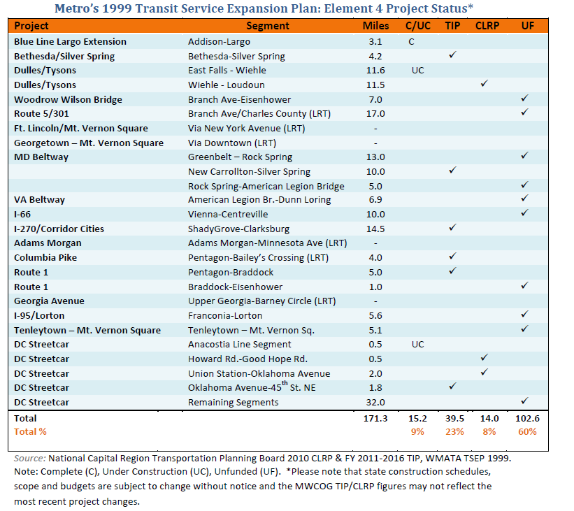
Status of Fixed-Guideway Projects
The table below identifies the area segment served, length of the segment, and the plan’s progress as of 2010. Since the time of original approval, 17 miles of planned LRT in the District of Columbia have been replaced by plans for a 37-mile streetcar network. The table reflects these changes. In Virginia, high-occupancy-toll (HOT) lanes are under construction along a section of the Capital Beltway, linking the priority lanes that are already in place along I-66, I-95, I-395 and the Dulles Toll Road. This mileage is not included in the table below.
Within the first decade of the planning horizon, 9% of the expanded fixed-guideway mileage is either complete or under construction, 31% is funded in either the TIP or the region’s 30-year Constrained Long-Range Plan (CLRP), and 60% remains unfunded to-date.


I think this overstates what is funded. For projects like the Purple Line and Corridor Cities Transitway, there is essentially only money for design, engineering, and property acquisition in the TIP. Construction is not yet funded.
On the other hand, there are a few valuable projects that are moving forward but weren’t, apparently, in the plan. I’m thinking of Navy Yard station access, H Street streetcar, Bethesda south entrance (in MoCo TIP), and Medical Center east entrance (not sure it fits into any category of the chart, but looking good for near-term funding and construction).
Overall, looking at the few items marked C or UC, these charts remind us of how underfunded the Metro system has been compared to the highway system.
I love this website, but the presentation on this post in particular should be updated and improved.
First, the map is way too small and difficult to enlarge.
Second, as Mr. Ross noted, the Funded/Unfunded column is simplistic. Why not add an excel chart or something that goes into more detail about each project?
Third, the chart that is attached might be better formatted, to include project categories instead of just listing them as they did. Mr. Ross also noted the chart is a bit simplistic. It’s a good summary but how about adding links where there is more detailed information?
I’m sure the data is available somewhere, but adding simple links to them for points 2 and 3 would greatly improve the quality and quantity of information.
@WRD
I’m glad you like the site, WRD. You can see the full version of the map and a corresponding table on pages 10 and 11 of the PDF linked-to at the top of the post.
This was intended to be a brief overview of the status of the 1999 plan. More details about the funded projects can be found in the CLRP and TIP documentation, available from COG/TPB.
@Michael
Well that taught me to read more closely! Thanks!
Please bring back the Tenleytown-Mt Vernon Sq streetcar idea!