Posts Tagged ‘travel patterns’

Survey Analysis Details Non-Work Trips on Metrorail

December 17th, 2013 10 comments

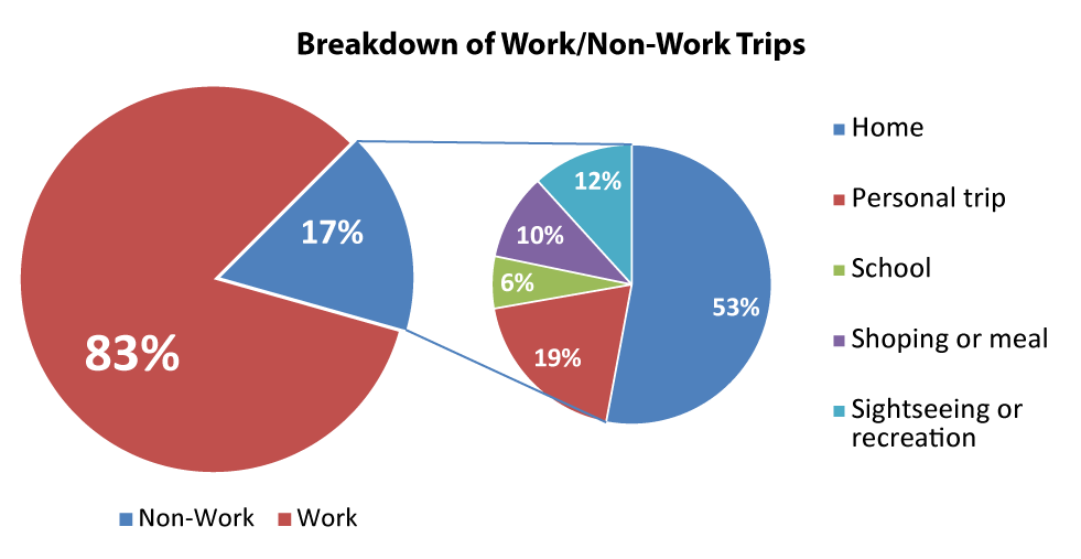
Almost one in five trips on Metrorail are NOT work-related. Who is making these trips, and where and why are they making them?

Woodley Park-Zoo 042511-131

Metrorail is how many of us in the region get to work.  But, as we will illustrate below, many of us also use it to do other things.

Using data from the 2012 Metrorail Passenger Survey, we were able to determine that about 125,000 or 17% trips on an average weekday do not involve travel either to or from ones’ place of work.   This is virtually identical to the results from the 2007 survey.  In order to understand how people use the system for non-work trips, we sorted out everyone who is either going to or coming from work from everyone else.    For example, a trip stopping off at the store after work would not be counted; however, a trip starting out at home and traveling to school would be counted.  In terms of where these non-work trips are going, most are returning home followed by “personal trip” and “shopping or meal.”  

Work-Non-Work-Pies-01

Read more…

Proposed 2040 Metrorail Network

December 5th, 2013 91 comments

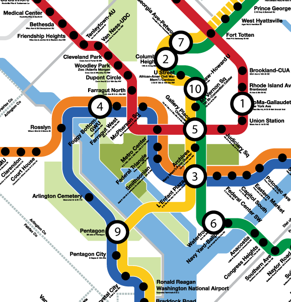
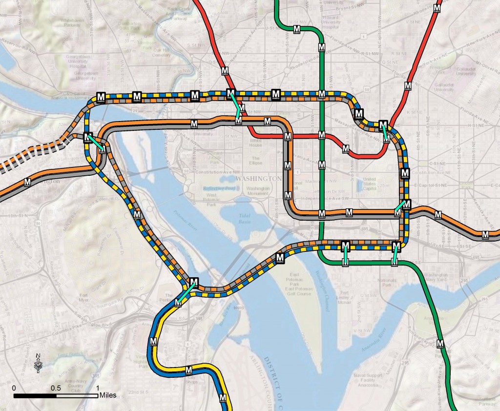
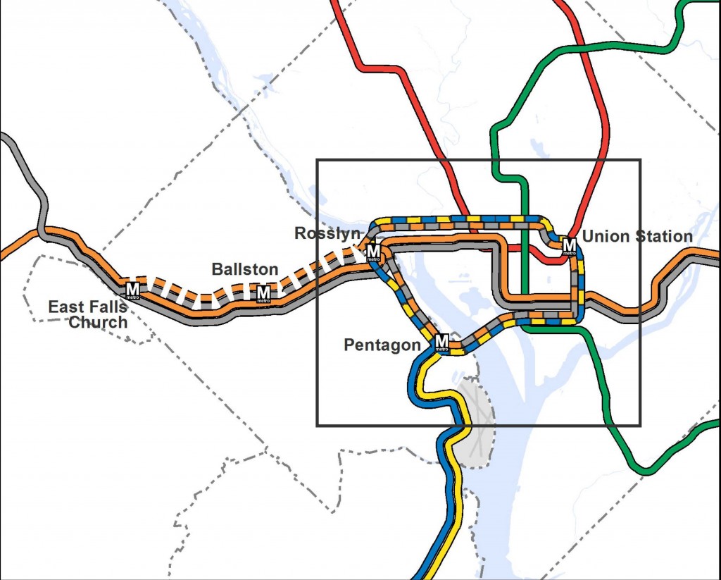
Step right up and check out the proposed 2040 core Metrorail configuration with new Blue and Yellow Lines and a third line in Virginia!
Proposed 2040 Metrorail Core Configuration
Proposed 2040 Metrorail Core Configuration

Proposed 2040 Metrorail Network

Proposed 2040 Metrorail Network

What does this network do? The proposed rail network shown above is expected to reduce future crowding on Metrorail, provide enough capacity for future development, and expand the reach of transit in the region, especially to regional activity centers.

Why are we proposing it? This rail network is part of the 2040 Regional Transit System Plan (RTSP). Its purpose is to develop the rail and surface transit network for 2040 that meets the needs of the growing Washington DC region.

What else have we considered? About a month ago, we posted about some of the possible long-range changes to the Metrorail core that we are considering as part of the RTSP. We analyzed four different core configurations, gathered your comments, and the final configuration for the core is shown above. As many of you commented, it is a combination of two of the scenarios (Scenarios B and C).

Next Steps: The next and final step for the RTSP is to use this configuration, along with the high capacity surface corridors, to conduct a final round of analysis. The output will provide us with information on ridership, mode share, levels of crowding, transfers, etc. and ultimately a final network for 2040.

Let us know what you think!

A few extra notes:

(1) The Metrorail network shown in this post will be layered with an extensive high capacity surface transit network to expand transit and meet the needs of employment and population growth in the region.

(2) For the plan to have validity and acceptability across the region and within the federal planning process, it is based on the region’s adopted cooperative land use forecast for 2040. We used the Aspirations Land Use scenario to stress test the core of the system, but ultimately the plan needs to start with the region’s adopted land use. As follow on work to this plan, we will be testing different land uses to see what else we can learn to improve long-range plans.

(3) All of the lines shown, as well as all of the high capacity surface transit corridors, will need corridor studies, alternatives analyses, and full engineering studies. This cannot be done at a regional level, but would need to happen on a project by project, line by line level. So, while we are showing a new Blue Line on M Street, it very well could be on N or P Streets.

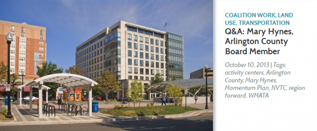
Q&A with Mary Hynes: WMATA and Arlington County Board Member

October 21st, 2013 Comments off

Picture1

Mary Hynes, a Metro Board Member, sat down with the Region Forward team to answer a few questions about the region’s biggest challenges, how Metro can help the region meet the goals in Region Forward, and how citizens can get involved. In addition to her role at Metro, Ms. Hynes is an Arlington County Board Member and the Chair of the Council of Governments’ Region Forward Coalition, the public-private group leading the effort to implement COG’s vision for the region’s future.

Q: What do you think are the regions biggest challenges?

Mary Hynes: “The economy is a big challenge. We are still figuring out ‘the new normal’ with the federal government. The issues of housing and how people move efficiently around the region are also critical. It’s critical that we understand how housing and multimodal transportation options fit into the bigger picture of achieving a thriving region built of individual vibrant communities – one that is also attuned and committed to meeting the social equity requirements of our diverse, sustainable region.”

Q: How does Metro help us meet our Region Forward goals?

Mary Hynes: “The Metro Board made a decision when considering how to frame its new strategic plan to key off of Region Forward. We – my colleagues on the Metro Board and Metro’s professional staff – looked at what regional leaders had done with Region Forward—the goals they had set—and said “Metro can be the catalyst that enhances regional mobility and convenes stakeholders to ensure a successful, integrated regional multi-modal system”. We worked with the Transportation Planning Board at COG to make sure Momentum and the TPB’s Priorities Plan are aligned.  It wasn’t hard because, in fact, there is regional consensus on the next set of transportation moves the region needs to make.

It’s an exciting time to be participating with COG and Metro. It’s a remarkable moment because people share the same vision. Leaders across the region have learned the same lessons. So the time is right!  Just as regional leaders did 50 years ago when planning Metro, we all must lock our arms, commit to a funding plan, and move forward together.”

Read the full interview!

Metro 2040 – Building the System that the Region will Need

August 5th, 2013 4 comments

The year 2040 may seem distant Logo_WMATA_RTSP_001 blackand removed, but in the context of transit planning, it is right around the corner. Metro’s Office of Planning is in the process of developing the 2040 Regional Transit System Plan (RTSP), which will outline a comprehensive regional transit network to prepare the region’s transit system for continued growth.

The RTSP, along with other elements that may be identified in the future, will need to be evaluated as necessary to meet the demands in the future.  The plan includes a combination of core system improvements, which are included as part of Metro 2025 above, as well as system connectivity and expansion projects. Most importantly, it combines all modes in the region’s transit system, whether or not Metro will build or operate them. The strategies in the plan are designed to both serve existing areas better and provide service to new areas, helping to realize Region Forward’s vision of regional activity centers with transit options that improve regional mobility, enhance commerce and competitiveness, and have environmental and health benefits for generations to come.

Read more…

Improving Core Metrorail Stations

June 28th, 2013 1 comment

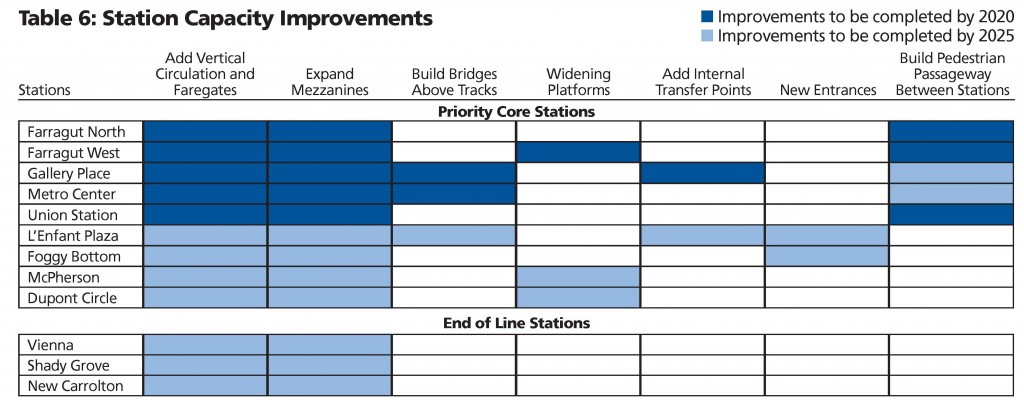
Improving and expanding capacity at high ridership stations will ensure safe and efficient operations and facilitate passenger movements from street-level to platform as well as transfers between lines. The proposed stations, most of which are in the system’s core, already experience crowding or would reach capacity by 2025. Proposed improvements vary from adding escalators and stairs to building pedestrian passageways connecting platforms within a station and between stations.

 Table of Station Improvements

Read more…

Momentum Outreach Update: Join the Conversation in Round 2!

November 8th, 2012 Comments off

Are you eager to tell us what needs to happen to make bus service more predictable and make your trip faster?

Do you have a great idea to help move more passengers through heavily-traveled stations in Washington and Arlington?

Do you sit in traffic and think, if only there were a fast, quick, comfortable transit option, life would be so much better?

Have you noticed a great concept or idea in another city’s transit system that Metro should implement?

If the answer to any of these questions is “Yes!” then please join the conversation about the future of your transit system at Momentum: The Next Generation of Metro.  We are using asking the public about how we can better serve their needs, and among other ways we are hosting questions at wmata.mindmixer.com!

Chart of the Week: 5-Year Ridership Change By Station

November 5th, 2012 4 comments

Inset of graphic showing top ten stations by absolute ridership growth, 2008 to 2012. Station #8, Morgan Boulevard, is off the map.  Click the image above to download the full graphic in PDF.

While rail system ridership is up nearly 2% over 2008 levels, this growth in ridership is not spread evenly across the Metrorail service area.  This map illustrates the locations of the stations in the top-ten for absolute ridership growth, 2008 to 2012.

  • In general, the Green Line corridor in DC is responsible for much of the station ridership increases.
  • Much of the ridership growth illustrated on the map can be attributed to redevelopment around some of our more recently opened stations, such as Georgia Ave-Petworth, Columbia Heights, Morgan Boulevard (off of image above), and NoMa-Gallaudet.
  • Additionally, redevelopment near Foggy Bottom-GWU, Waterfront and Shaw-Howard U has contributed to increased ridership at those stations.
  • The increase at Pentagon could be due to increased express bus and commuter bus activity, with federal workers heading to new BRAC-related work sites along the I-95/395 corridor.

For a full version of this graphic, download the PDF:  Top Ten Stations for Ridership Growth, 2008 to 2012 (1 Mb)

Data Download: Metrorail Ridership by Origin and Destination

October 31st, 2012 25 comments

Photo courtesy Josh Bancroft (click for original context)

Every day, Metro gathers a vast amount of information on how customers use the system – where and when they pass through turnstiles and board buses, how they pay, and more. There’s much to be learned from this data, and many in the past have done so.  We’ve heard through MindMixer, Metro’s new online community engagement site, that more detailed ridership statistics would be useful.  So in the spirit of open data and collaboration, here’s a data download of rail station-to-station passenger counts, by time period, by day of the week, for May 2012.

May 2012 Metrorail OD Table by Time of Day and Day of Week (.xls, 6.8 MB)

This data can answer many questions, such as: Where do passengers entering at one station go? Where do late-night riders enter the system? How does Saturday ridership differ from Sunday? Which stations are most commuter-oriented, and which are most lively at midday and evening hours?

What does this data tell you? Do you see any patterns? Feel free to post a link in the comments!

What other data that would help answer additional questions?

Technical notes about this data:

  • The data show average ridership, averaged across all days in May 2012, excluding Memorial Day. (We typically use May as an “average” month, since it falls in the middle of seasonal swings, is relatively unaffected by extreme weather, etc.)
  • Time period shows the time the passenger entered (not the time they exited).
  • AM Peak = opening to 9:30am
  • Midday = 9:30am to 3:00pm
  • PM Peak = 3:00pm to 7:00pm
  • Evening = 7:00pm to midnight
  • Late-Night Peak = Friday and Saturday nights only, midnight to closing

Notice for Super NoVa Transit/Transportation Demand Management (TDM) Vision Plan Public Meetings

February 2nd, 2012 Comments off


Metro is working with the Virginia Department of Rail and Public Transportation (DRPT) on the Super NoVa project to identify travel needs, evaluate current gaps in transit and TDM programs, and identify a vision to improve mobility. DRPT will be hosting a set of four public meetings through northern Virginia to gather your comments/ideas on bus, rail, carpooling, and vanpooling. The Super NoVa region considers the needs of commuters in northern Virginia as well as those from Washington D.C., Maryland, and West Virginia.

Citizens are invited to learn more about the study and provide feedback by attending any one of the following identical meetings. For special assistance or information, call 804-786-4440 or TDD 711 at least 48 hours in advance of the meeting date.

Monday, February 13, 2012
6:30 p.m. to 8:30 p.m. Ida Lee Recreation Center
60 Ida Lee Drive
Leesburg, VA 20175

Snow date: 2/20/12

Tuesday, February 14, 2012
11:30 a.m. to 1:30 p.m. Shops at 1750 Crystal Drive
1671 Crystal Square Arcade (Underground, near Rite Aid)
Arlington, VA 22202

Snow date: 2/21/12
(No presentation at this location)

Wednesday, February 15, 2012
6:30 p.m. to 8:30 p.m. Warrenton Community Center
430 E. Shirley Avenue
Warrenton, VA 20186

Snow date: 2/22/12

Thursday, February 16, 2012
6:30 p.m. to 8:30 p.m. Spotswood Baptist Church
4009 Lafayette Boulevard
Fredericksburg, VA 22408

Snow date: 2/23/12

Other mechanisms to participate include:

Website Online Survey Facebook Twitter

Written comments also may be sent to: Super NoVa Transit/TDM Vision Plan, 11400 Commerce Park Drive, Suite 400, Reston, VA 20191.

Si usted necesita servicios de traducción a participar, por favor manda un email: espanol@kimley-horn.com

What Does the State of the Commute Survey Tell Us?

January 11th, 2012 1 comment

State of the Commute Survey Results

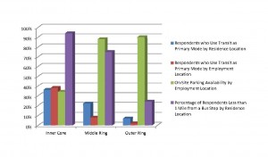
Last summer, the Metropolitan Washington Council of Governments (MWCOG) posted the results from the 2010 State of the Commute (SOC) Survey. Metro planners are reviewing the results now in support of our Regional Transit System Plan, which is looking to better connect areas of concentrated growth, such as the regional activity centers, and increase core capacity through 2040. The survey is conducted every three years to help MWCOG’s Transportation Planning Board better understand commuting trends and evaluate the effectiveness of its Commuter Connections program, which provides information about and benefits for commuting by transit and carpooling instead of single-occupancy vehicles (SOV).

Read more…