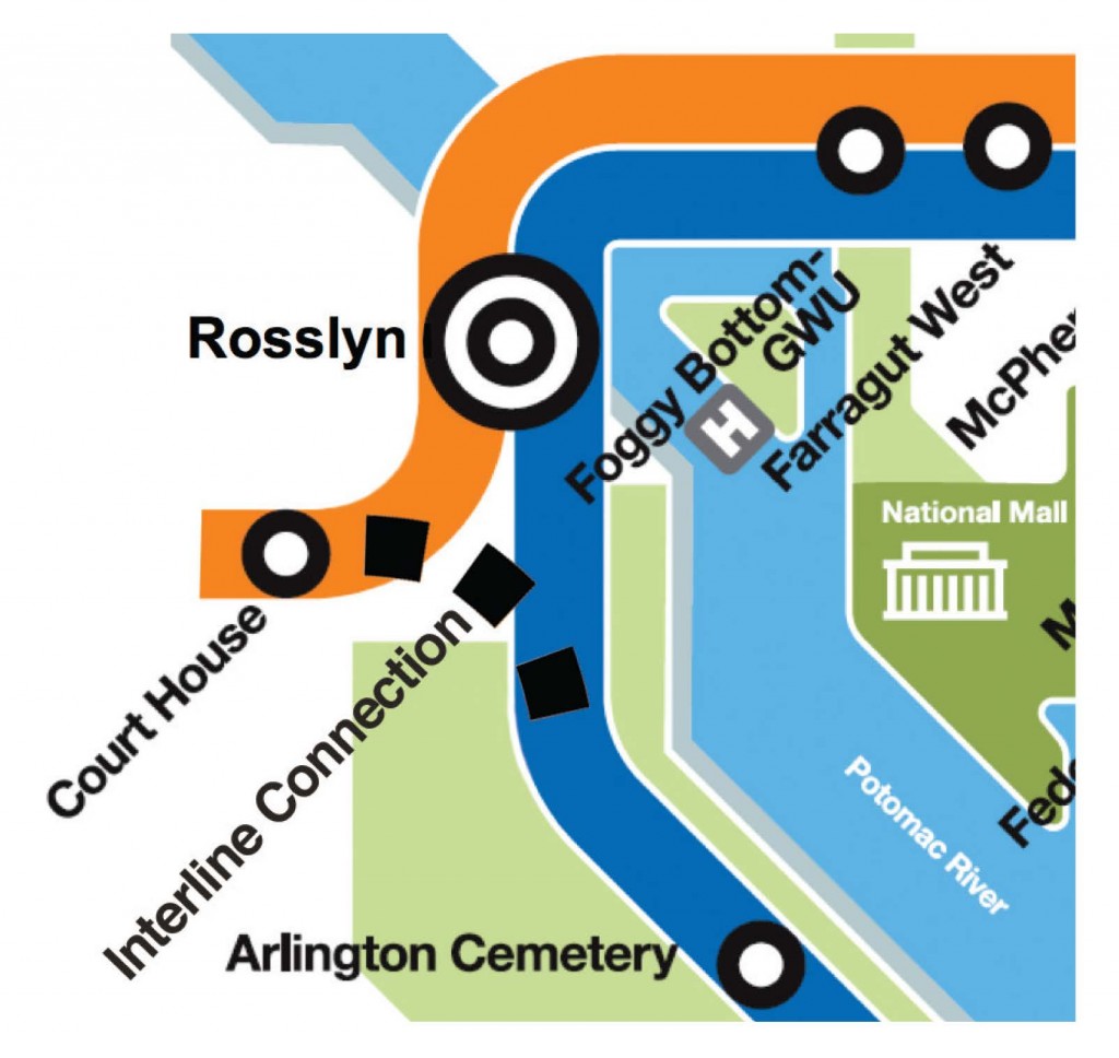
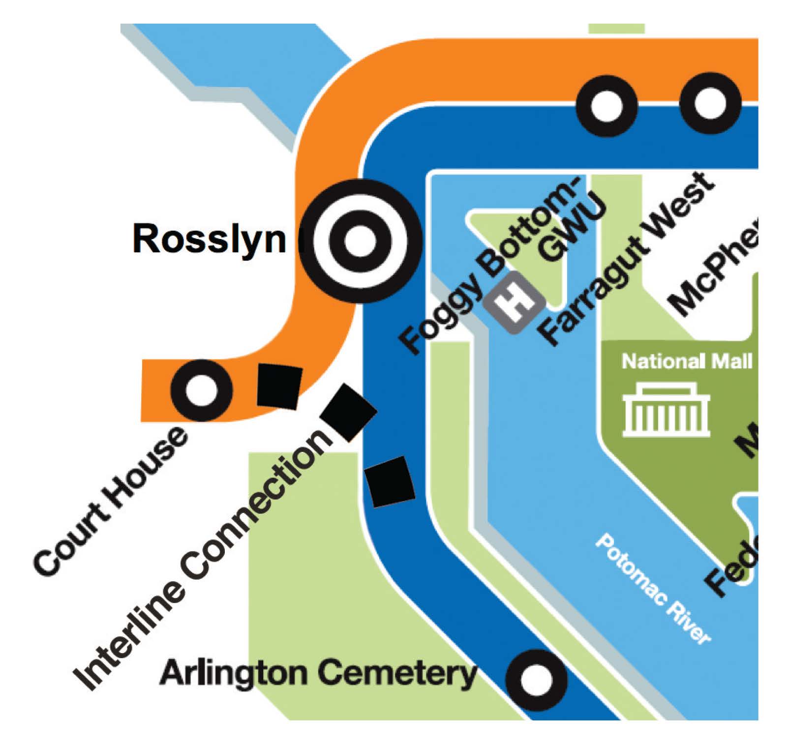
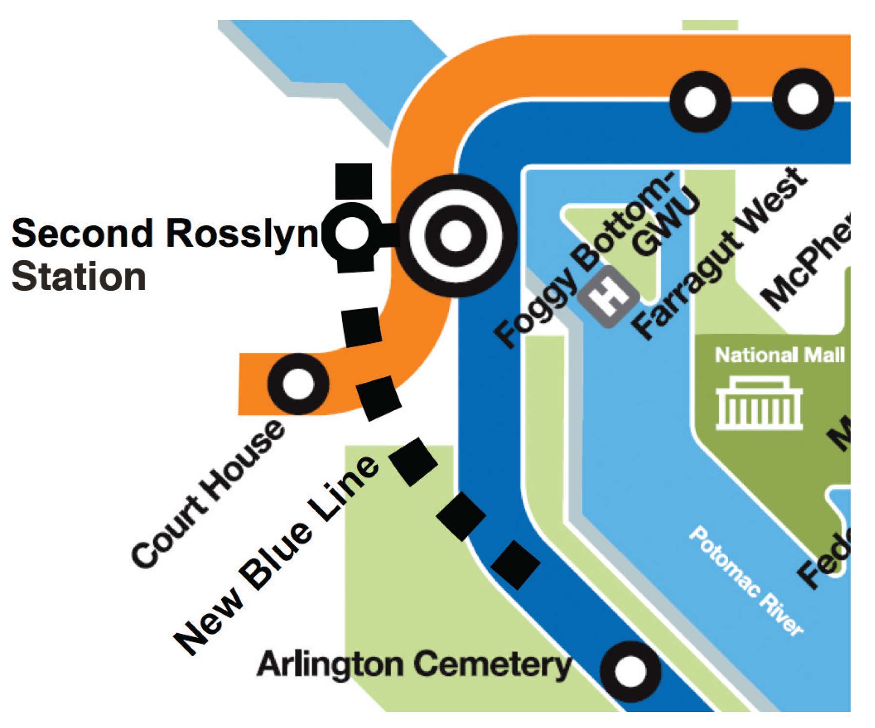
Adding new Blue Line connections seeks to restore train frequencies to every six minutes during the peak period between Pentagon and Rosslyn stations, resulting in less waiting time and crowding for Blue Line riders in Northern Virginia. Once the Silver Line opens, the Blue Line service will operate every 12-14 minutes as opposed to the previous six minutes. The feasibility analysis is currently underway and has identified two potential alternatives to create new connections:
- Alternative 1: Add rail track that would create a new connection between the Blue and Orange/Silver Lines, or
- Alternative 2: A second Rosslyn Station for a new Blue Line with an underground passageway to the existing Rosslyn station, which would connect to the Orange/Silver Lines with a pedestrian tunnel.

Read more…
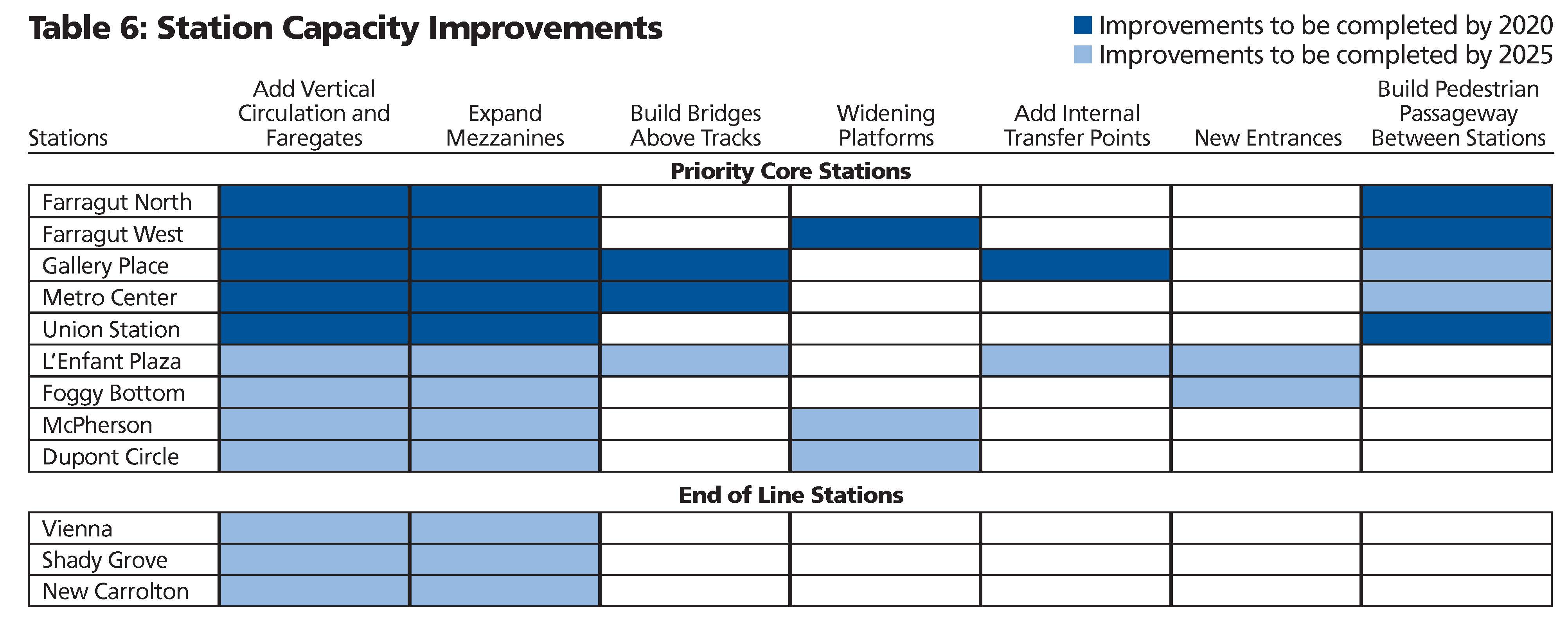
Improving and expanding capacity at high ridership stations will ensure safe and efficient operations and facilitate passenger movements from street-level to platform as well as transfers between lines. The proposed stations, most of which are in the system’s core, already experience crowding or would reach capacity by 2025. Proposed improvements vary from adding escalators and stairs to building pedestrian passageways connecting platforms within a station and between stations.

Regular readers of this site know that Metro is developing a Strategic Plan, Momentum, which makes the case for additional major capital investments we’ll need to accommodate the region’s growth by 2025. For those of you unfamiliar with the details of Momentum, one of the driving factors behind many of the initiatives is the need for improved core capacity to boost Metro’s ability to carry more riders in the system’s core.

BART System
Read more…
Metro’s Parking Office recently completed new bike rack installations at Shady Grove and Brookland-CUA stations, with parking for over 80 additional bicycles. This work was completed as part of our Pedestrian and Bicycle Capital Improvement Program.
The new racks at Brookland are located on the west side of the station, just off the Metropolitan Branch Trail. At Shady Grove, the new bicycle racks are in two places on the west side: near the station entrance and bus loop, and near the Kiss & Ride loop where bicyclists had previously locked to handrails.


Next up? Pedestrian improvements at Glenmont station – stay tuned!

Inset of graphic showing top ten stations by absolute ridership growth, 2008 to 2012. Station #8, Morgan Boulevard, is off the map. Click the image above to download the full graphic in PDF.
While rail system ridership is up nearly 2% over 2008 levels, this growth in ridership is not spread evenly across the Metrorail service area. This map illustrates the locations of the stations in the top-ten for absolute ridership growth, 2008 to 2012.
- In general, the Green Line corridor in DC is responsible for much of the station ridership increases.
- Much of the ridership growth illustrated on the map can be attributed to redevelopment around some of our more recently opened stations, such as Georgia Ave-Petworth, Columbia Heights, Morgan Boulevard (off of image above), and NoMa-Gallaudet.
- Additionally, redevelopment near Foggy Bottom-GWU, Waterfront and Shaw-Howard U has contributed to increased ridership at those stations.
- The increase at Pentagon could be due to increased express bus and commuter bus activity, with federal workers heading to new BRAC-related work sites along the I-95/395 corridor.
For a full version of this graphic, download the PDF: Top Ten Stations for Ridership Growth, 2008 to 2012 (1 Mb)

Photo courtesy Josh Bancroft (click for original context)
Every day, Metro gathers a vast amount of information on how customers use the system – where and when they pass through turnstiles and board buses, how they pay, and more. There’s much to be learned from this data, and many in the past have done so. We’ve heard through MindMixer, Metro’s new online community engagement site, that more detailed ridership statistics would be useful. So in the spirit of open data and collaboration, here’s a data download of rail station-to-station passenger counts, by time period, by day of the week, for May 2012.
May 2012 Metrorail OD Table by Time of Day and Day of Week (.xls, 6.8 MB)
This data can answer many questions, such as: Where do passengers entering at one station go? Where do late-night riders enter the system? How does Saturday ridership differ from Sunday? Which stations are most commuter-oriented, and which are most lively at midday and evening hours?
What does this data tell you? Do you see any patterns? Feel free to post a link in the comments!
What other data that would help answer additional questions?
Technical notes about this data:
- The data show average ridership, averaged across all days in May 2012, excluding Memorial Day. (We typically use May as an “average” month, since it falls in the middle of seasonal swings, is relatively unaffected by extreme weather, etc.)
- Time period shows the time the passenger entered (not the time they exited).
- AM Peak = opening to 9:30am
- Midday = 9:30am to 3:00pm
- PM Peak = 3:00pm to 7:00pm
- Evening = 7:00pm to midnight
- Late-Night Peak = Friday and Saturday nights only, midnight to closing

Back in December, we told you about the Metrorail Bicycle and Pedestrian Access Improvements Study, which recommended ways for enhancing bicycle and pedestrian access in and around Metrorail stations. Since then, Metro has been developing a capital program aimed at implementing some of these recommendations. Here is an update on our progress and some discussion on what’s next:
Recent Highlights
In February, Metro’s Board of Directors adopted a goal to increase bike mode share from 0.7% to 2.1% by 2020 and 3.5% by 2030. Around the same time, we made improvements to the bicycle section on Metro’s website. This spring, we surveyed use and capacity of bike racks at Metrorail stations and conducted an inventory of unmet bike and pedestrian needs at Metrorail stations.
Read more…

Screen capture of live parking information for Fort Totten. Click image for live site.
As part of Metro’s ongoing effort to make parking more convenient for riders, a trial of real-time sensing has been underway at the Fort Totten Metro Kiss and Ride Lot for the past few months. This system uses sensors embedded in the pavement and in parking meters to let users know when spaces are available in the Kiss and Ride Lot, and when they should save time, energy and reduce their carbon footprint by driving to a different lot or using some other mode to access Metro. Eventually, we hope that a similar sensors and monitoring technology will be available at all Metro metered parking spaces as a customer service to riders and to improve transit access, information and use. Information on parking space availability reduces traffic cause by motorists search for parking and reduces pollution from vehicles being driven around in the search for parking.
This real-time space availability information from the Fort Totten Kiss and Ride Lot is currently available on Metro’s website on the Fort Totten parking page:
http://www.wmata.com/rail/parking/parking_detail.cfm?station=28
Read more…
Metro’s early experience with promoting TOD took place at below-ground rail stations in established urban settings that did not require the provision of transit access facilities beyond connections from sidewalks to the stations below. More recently, WMATA’s opportunities to develop its land to support TOD have been predominantly in suburban rail stations that include extensive parking lots, bus bays, and facilities for taxis, bicycles, customer pick-up and drop-off, and ADA patrons.
The default agency policy in recent years has been to replace existing facilities with a like amount and kind of facilities on a reduced footprint, and to emphasize transit operational functionality over urban design issues. For example, this approach has tended to favor placing parking structures and bus bays adjacent to the station in lieu of pedestrian facilities, public spaces and mixed-use development. However, public feedback has prompted WMATA to reassess the appropriateness of this default approach, and there is a need for new thinking about how future patrons should arrive at suburban stations; how transit operations should function in TOD contexts; and how to better meet local development policy objectives.

Development plan for Twinbrook Metrorail station. Click the image for more information.
Over the past five years, WMATA has made a number of significant policy and program changes to recognize the changing development environment at suburban rail stations. For example, in 2008 WMATA adopted a new set of real estate development guidelines (1.91 MB PDF), and the first real estate projects implementing those guidelines were initiated in the summer and fall of 2010. While the evolution of WMATA’s planning and land development practice is underway, it is far from complete. WMATA’s most recently-launched TOD projects confront the agency with the immediate challenge of replacing first-generation, auto-oriented transit access facilities with a new generation of facilities that supports transit access, transit operations, and TOD.
Read more…


Recent Comments