Posts Tagged ‘PCN’

16th Street Plan Offers Big Benefits, Great Value

April 25th, 2016 Comments off

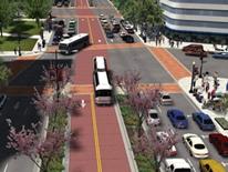
DDOT’s 16th Street transit plan will benefit Metrobus riders, drivers and taxpayers alike and could “break even” in just a year and a half.

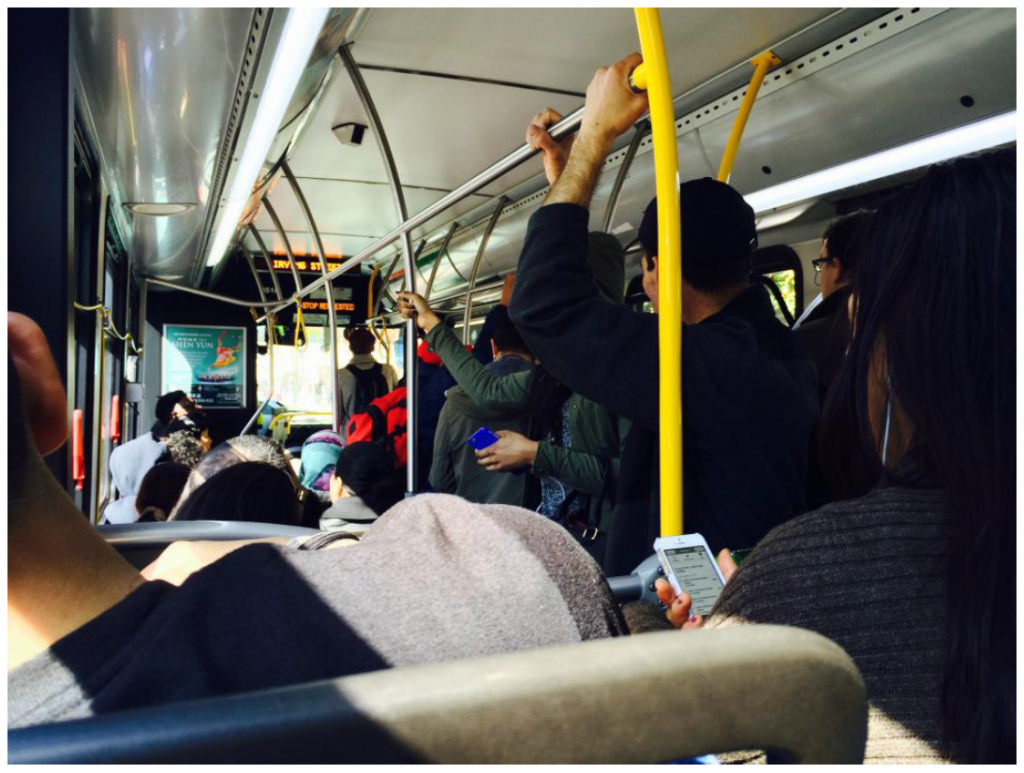
We know the problems with buses on 16th Street NW: overcrowding, slow speeds, lengthy boarding times, and bunched buses. While both the District Department of Transportation (DDOT) and Metro have made several small but important improvements in the past two years to improve traffic flow and increase bus capacity on 16th Street, both agencies realize that more needs to be done. Now, after a year of detailed study in partnership with Metro, DDOT has developed a set of recommendations (PDF) that will save time and improve the customer experience in the coming years. As an added bonus, it comes with a relatively cheap price tag, yielding great value for taxpayers.

16th Street Crowding

Riders aboard a crowded S-Line bus (click for study information)

Read more…

Metro Considers H/I Bus Lanes to Ameliorate Streetcar Construction

November 23rd, 2015 6 comments

Construction of the K Street Transitway and Union Station to Georgetown Streetcar might result in some growing pains, but Metro & DDOT already have a remedy.

The H/I/K Streets NW Corridor is a heavily congested corridor with traffic frequently backed up and traffic jammed at rush hour. Fortunately, DDOT has approved the K Street Transitway, an exclusive two-way, two-lane median east-west transitway between 20th and 9th Streets NW, to improve the transit and traffic conditions in this corridor. The transitway would also be utilized by a future Union Station to Georgetown streetcar.

Construction of the transitway will likely take a lane or two away from an already congested corridor and Metro would need to reroute our buses to ensure safety and performance.

Current K Street bus service would likely need to detour via H and I Streets NW, but H and I Streets are at capacity!

At rush hour, cars, bikes and pedestrians all fight for limited street space along H and I streets NW.  It is common to see bottlenecks, strings of red brake lights, packed crosswalks and cars moving at a sluggish 10.8 MPH through the corridor during the PM Peak.   These delays impact our bus service along the corridor.  How much service do we have there?  A lot.  Read more…

Imagining Metrobus 2.0

October 20th, 2014 23 comments

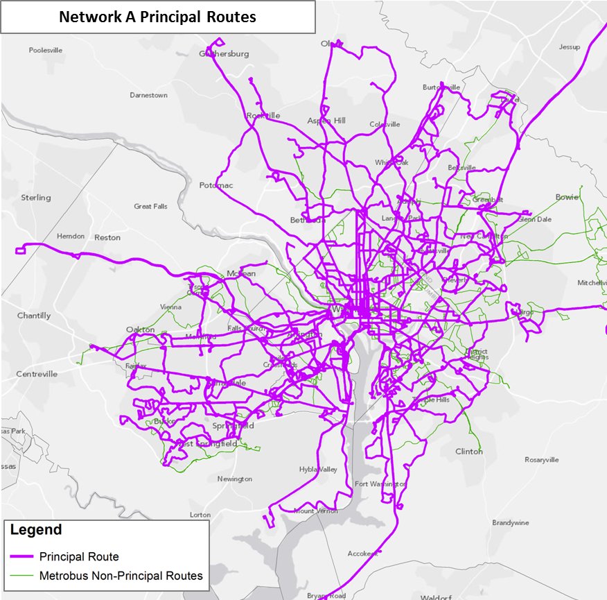
Metro is re-imagining the region’s bus network to improve travel times, enhance connectivity, and deliver service cost-effectively.

Network A - Principal Routes

Over the past year, as part of the Metrobus Network Effectiveness Study, Metro began exploring potential future Metrobus restructuring scenarios based on the region’s growth trajectory over the next two decades. The scenarios also reflect the market segments where Metrobus can be more effective — places like the urban core, activity centers, and major arterial streets. Planners took the Metrobus network in the region’s Constrained Long-Range Plan (CLRP) for 2030 as the basis of comparison and formulated several network restructuring alternatives. This post will introduce the alternative networks, while future posts will present the performance of the networks, as well as a completely new proposed network built from the ground up. The flow chart below illustrates the network alternatives, followed by a brief explanation about each alternative.

Read more…

Funding Metro – A Critical First Step

September 22nd, 2014 1 comment

Local leaders are set to commit to Metro’s long term state of good repair needs for the first time through the region’s transportation plan, but the plan omits key investments that are critical to solving some of the region’s most critical needs.

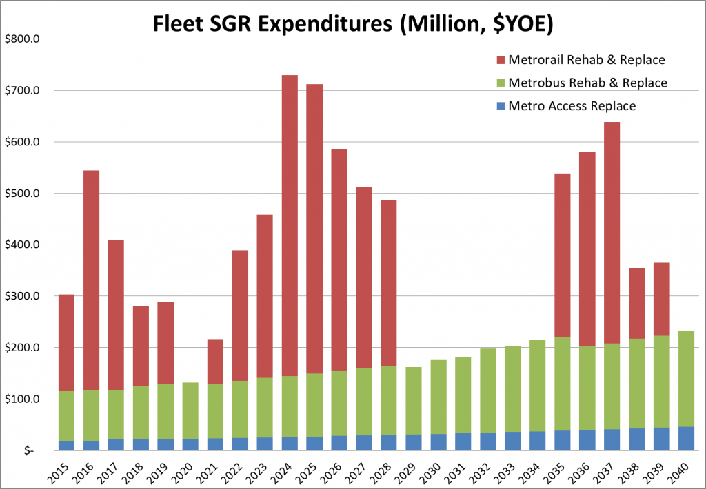
This fall the region’s transportation leaders will approve an update the Constrained Long Range Plan (CLRP) financial plan, required by federal law every four years, to ensure the region’s ability to pay for transportation expenditures with reasonably anticipated revenues. During the 2014 update, Metro collaborated with staff from the Transportation Planning Board (TPB), the region’s Metropolitan Planning Organization, and the three state DOTs to identify funding for the system’s long-term operations and maintenance (O&M) and capital needs.  The draft plan, which expresses the region’s major transportation priorities, is scheduled to be adopted by the TPB on October 15th.

Metro's future capital needs to repair and maintain the existing fleet

Projection of Metro’s future fleet State of Good Repair (SGR) capital needs

Read more…

Metro Anchors the Region’s Growth

February 14th, 2013 Comments off

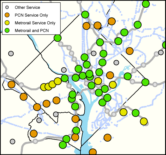
Regional Activity Centers in the core jurisdictions served by high-quality Metro service. Click the image for a full regional map.

Of the 120 COG regional activity centers in the Metro Compact Jurisdictions, 81 are now or will soon be served by high quality Metro transit, either Metrorail or the Metrobus Priority Corridor Network (PCN). That means that two-thirds of these activity centers are primed to support transit-oriented developments. The map above illustrates the activity centers in the core jurisdictions and their level of transit service. Click the image  for a full regional map.

Some jurisdictions have placed a greater emphasis on high-quality transit service when deciding upon areas to designate as regional activity centers.  The chart below shows the total number of activity centers per jurisdiction and the percentage served by Metrorail and/or the PCN.  The core jurisdictions (the District, Arlington and Alexandria) each have over 80% of their activity centers served by high-quality Metro transit.  The beltway jurisdictions (Montgomery, Prince George’s and Fairfax counties) have between 48% and 70% of their activity centers served.   Loudoun County, soon to be added to the compact with two activity centers receiving Metrorail service when the Metrorail to Dulles Phase II comes online, has the lowest percentage of activity centers served by Metro.

The relationship between regional activity and high-quality transit is no accident.  Economic activity gravitates towards areas of greater accessibility, including Metrorail station areas and commercial corridors — once streetcar routes — currently served by Metrobus. However, transit service can also be extended to areas of economic activity which developed due to good highway accessibility, such as Tysons Corner.

As the local jurisdictions continue to focus population and employment growth into these areas, Metro and other regional transit operators are working to connect them to the regional core and to one another through high-quality transit.  It is clear from the current levels of highway congestion that Metropolitan Washington needs more high-quality Metro service (bus and rail) in order to support the growth anticipated over the next 25 years.

One goal of Momentum, Metro’s strategic planning process, is increasing regional mobility and connecting communities.

About the COG Activity Centers

The activity centers list, recently updated by the Metropolitan Washington Council of Governments (COG), describes where the local jurisdictions plan to focus household and job growth in order to support regional goals of transit-friendly development patterns and sustainability. This updated list includes 120 activity centers within the Metro Compact Jurisdictions (including Loudoun County) and additional 19 within the COG planning area not served by Metro, including Charles, Frederick and Prince William Counties, and the cities of Manassas and Manassas Park.

Categories: Impact Tags: , , , , ,