Making every Metrorail station area walkable could reduce regional congestion without breaking the bank.
This is part three of a three-part series.
In the previous two posts we’ve laid out a case for making all transit stations walkable as quickly as possible.
- Increasing walkability and density at station areas has huge impacts on transit mode share and can take tens of thousands of cars of the road every single day.
- At a regional level, walkable station areas have an equivalent impact on congestion as a quarter trillion dollars in “last mile” infrastructure (see pages 37, 38, 43, 48).
Maximizing the capacity of the existing transit network while intelligently investing in station area connectivity would combat regional congestion just as effectively as trying to “build our way out of the problem”. And unlike many potential interventions, the market actually wants to do this for us.
Perhaps it is time to harness these market forces to make the areas around our transit network walkable and implement this low-cost congestion-busting paradigm. As for where to begin – well, we have a few suggestions…
Existing Walkability Near Metrorail Stations
The map below shows the range of existing walkability conditions near the Metrorail network and helps answer the question of how much of a half-mile radius of each station a person can walk to. The higher the percentage, the better the pedestrian network coverage. As shown, many of the station areas are under performing relative to their potential walkability. If walkability = connectivity and connectivity = mode share, then just imagine the impact on the region’s roads if we could focus on taking station areas with low accessibility and invest in some relatively easy, short-term solutions like sidewalks, pedestrian bridges, crosswalks, and smart, transit-oriented development to take maximum advantage of the existing Metrorail system and take tens of thousands of cars off the road each day.
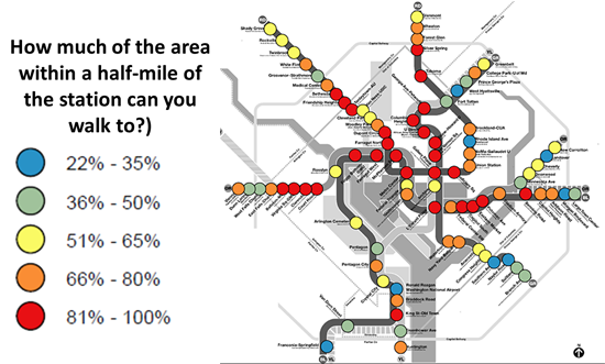
How much of the area within a half-mile of our Metrorail stations can you walk to?
Read more…
Improving pedestrian connectivity takes cars off the road at a formidable clip – rivaling the power of all of the region’s planned roadway additions and “last mile” transit connections. Cheaply and quickly.
This post is part two of a three-part series.
The data is finally in, and we now know that walkable station areas result in fewer motorized trips, fewer miles driven, fewer cars owned, and fewer hours spent traveling. And when we improve the pedestrian and bicycle access and connectivity to Metrorail station areas, ridership goes up, putting a major dent in congestion by taking trips off the roadways. Earlier, we discussed what it means to build walkable station areas and research shows the tremendous benefits to the region of making this a priority.
First, our data confirms that when walking access to transit is improved, transit ridership goes up – way up. In the 2040 Regional Transit System Plan (RTSP), we stress tested TPB’s transportation model to improve walkability to the transit network and saw huge increases in transit linked trips. These trips go up by about 10% region-wide and we get an increase in transit mode share for all regional trips by 0.5%. That’s over and above the roughly one percent increase in mode share we anticipate occurring as a result of building the entirety of the CLRP, an impact about half that of constructing all of that transit.
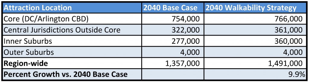
Source: Regional Transit System Plan
Read more…
One solution to the region’s crippling congestion could be right under our feet – literally.
This post is part one of a three-part series.
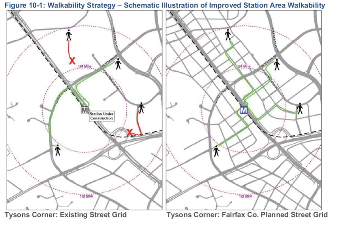
Illustration of possible walkability improvements that could occur in/around Tysons Corner. From Regional Transit System Plan
The region is abuzz with $220B of planned new transportation investments – the Purple Line, HOT Lanes, new streetcar lines, and additional roadways. Though there is not one dollar currently pledged to add capacity to Metro, these other investments may help the region chart a course away from leading the country in congestion (pdf).
However, for a quarter trillion dollars, one would expect that collectively these projects would have significant impacts on the region’s congestion. While there are some benefits – vehicle miles traveled (VMT) per capita are expected to decline and transit mode share may increase by one percent – overall increases in VMT are expected to outpace road construction, leading to a 38% increase in the number of lane miles of congestion (pdf). But is there another way to get more bang for our buck?
Make station areas walkable. Every one of them. Now.
Read more…


Recent Comments