
Try Out the New “Metrobus Explorer” Tool and Tell Us What You Think!
We want your feedback on a new online tool, Metrobus Explorer, which allows visualization of Metrobus service frequency and geography.
One of the biggest challenges facing bus transit is making the service extremely easy to understand. Metrorail stations are filled with customer information, including system maps, fare and travel time tables, station-ahead lists, and passenger information display systems (PIDS) screens, leaving little guesswork for the savvy traveler. Moreover, with limited real estate available for customer information, Metrobus stops are often at a disadvantage. While Metro continues to improve bus stops around the region — including the design and installation of new diagrammatic bus system maps — information technology is also playing an important role in filling the bus customer information gap, including BusETA, information displays, and trip planning sites and apps.
Metro’s Office of Planning is developing a new online tool called Metrobus Explorer that is geared to answer two questions about the Metrobus network: “How often do buses arrive at a given stop (or set of stops), and where do they go from there?”
Screen shot of the bus frequency and spider map tool. Click the image to access the live tool online.
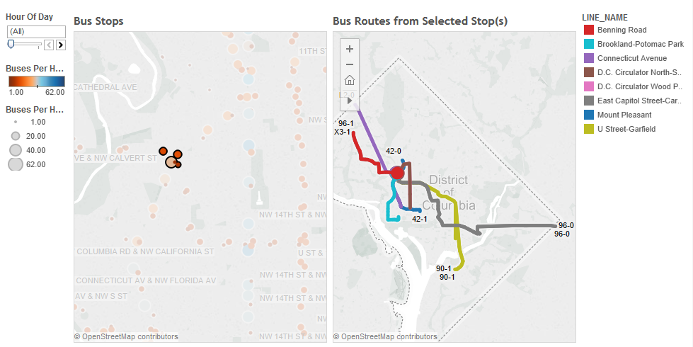
When opening Metrobus Explorer, the user is presented with a first map (left panel) of all the Metrobus stops symbologized by the frequency of service at them. The bigger and bluer the dots, the more frequent the buses.
Upon selecting a stop or a group of stops, a second map appears (right panel) illustrating where the buses go from the selected stops, generating a personalized bus spider map. Routes are colored by line and include route name and direction labels.
Please note that bus routes are keyed to individual stops by direction, meaning that if you want to see a full bus route from end to end, you have to select both stops on either side of the street.
Would a tool like this be useful to Metrobus customers? Real estate developers? Tell us how this tool could be used if a full-day version were available. We’d love to know what you think, either in the comments.
A note on how this tool was developed:
This tool was developed using the GTFS feed that WMATA makes available to web and mobile app developers. The GTFS data was imported into a database where it was converted into a format readable by the Tableau data-viz software.

This is great!
How do we facilitate your inclusion of other jurisdictions’ service? I’m assuming that this tool is reading GTFS feeds in the background. Is there some post-processing that the GTFS files need before they can be called by your tool?
@Stephen
Hi, Stephen:
We built this (quickly) in Tableau by importing the Metro + Circulator GTFS data into an Oracle database and writing two queries, one for each panel, and tableau runs the queries and stores the results in a data extract.
If we had a regional GTFS file (we’re working on it, still) it would be a no-brainer. I could investigate pulling other agencies’ GTFS into the same database but I’d have to look out for ID conflicts in the different tables. I thought transit.land had the ability to export the GTFS of multiple agencies in one distribution but I can’t get that to work…
If we were to incorporate this into wmata.com, we would likely use the Trip Planner dataset that does contain all regional operators.
This is fantastic!! Would LOVE to see an added search feature for address selecting x mile radius of bus stops from that address.
Nice tool but finding out where a bus route goes isn’t really that hard. The mapping function is straightforward but the frequency aspects are confusing. Does the hours of the day refer to the amount of service running at 4 a.m., 8 a.m., etc.? You could use a bit more clarity on that. Change Hour of Day perhaps to Time of Day and use a time format (8:00) vs. (08). AM and PM may be easier for folks than military time, too.
This is great! So helpful when nearby buses don’t all use the same bus stop. Makes it easy to see what parts of the city are a straight shot away.
Agree that “all stops within x miles” of a point would be helpful. In addition, it’s not very mobile-friendly, which is when I would need to use it, so that’s a top priority.