
Rail Ridership Data to Help the Region Plan for SafeTrack
To help the region and our partners plan alternatives and mitigate the impacts of SafeTrack, Metro releases rail ridership data applicable to this important maintenance effort.
 Rail Link Volumes: This data describes the number of customers on board trains between two contiguous stations, for a given hour of the day, then assigned to rail links. For example, the link volume from Bethesda to Friendship Heights is the sum of everyone who boarded upstream, minus those who exited at or before Bethesda. This can be useful for planning SafeTrack mitigation efforts because it gives a first-order estimate of the potential demand for a bus bridge, for example.
Online Interactive Map of Metrorail Link Volumes, average weekday and Saturday in May 2015
Metrorail Link volumes, average weekday in May 2015, by hour, by line color (580kb, .xlsx)
Rail Origins and Destinations: This detailed origin-destination rail ridership data, including information on weekends, has been shared previously. It can be useful during SafeTrack to understand the final destinations of impacted trips and better estimate what alternatives the impacted riders might seek.
Service Plans and Changes In Service: for schematic diagrams of rail service plans (244kb, zipped PNG files), and maps of the temporary change in rail service compared to today, for all SafeTrack surges.
UPDATE: 5/31/2016, 5:30 PM
We have pulled the data requested by Mayor Muriel Bowser in her letter to Metro dated 5/25/2016: Origin-destination data for the same time period over the past three years. (25 MB, zip file of three CSV files.)
UPDATE: 6/6/2016, 3:00 PM
We have created a map of the number of available parking spaces (PDF) at Metrorail stations pre SafeTrack.
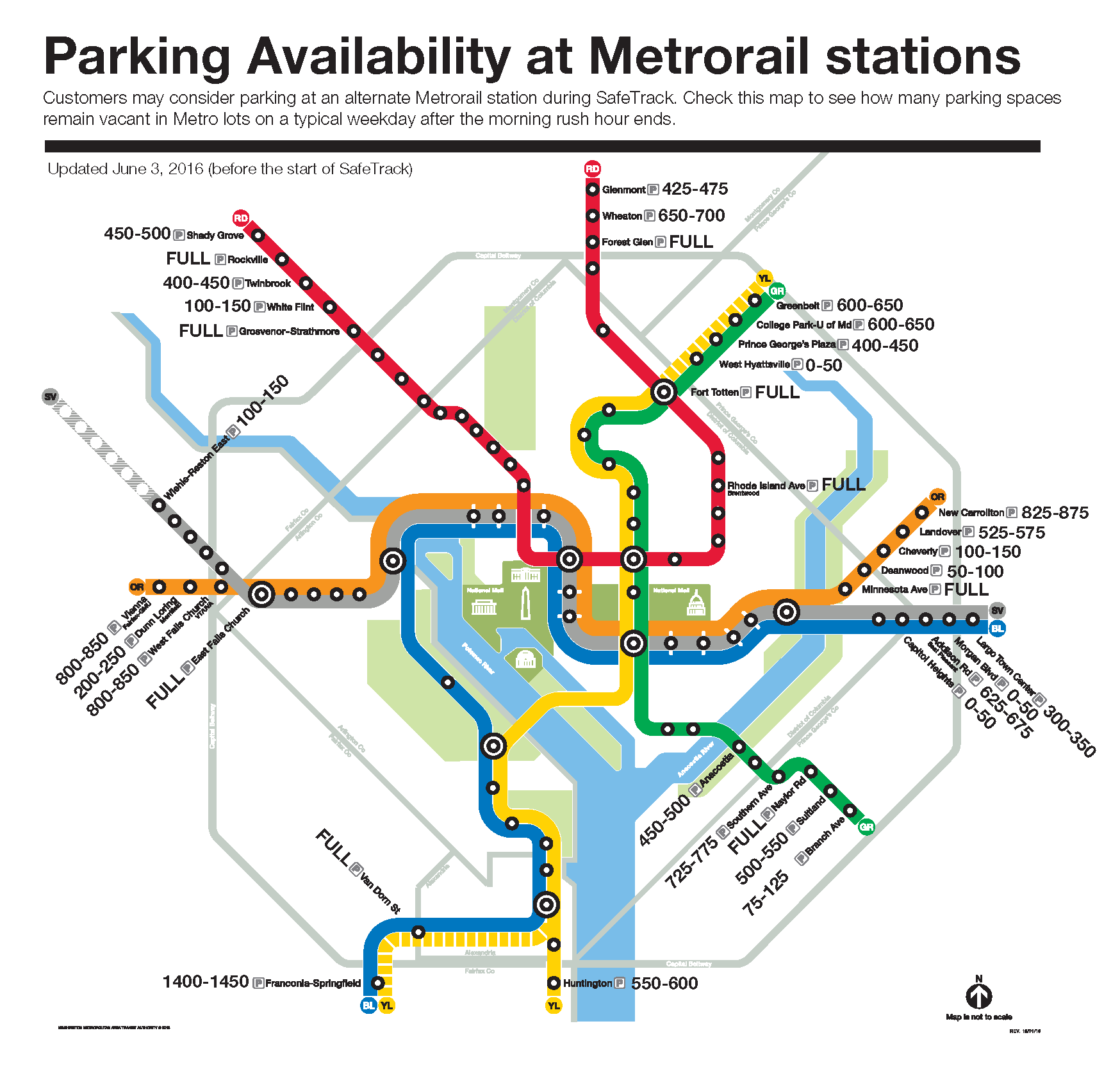
Parking availability at Metrorail stations. Click for PDF version.

For the period of work on Yellow/Blue line in July, does the Metro plan to allow passanegrs use VRE between King St.-L’Enfant or Union St?
Would it be possible to have a shuttle between these stations on VRE tracks?
I’m sure it’d halp many customers going to downtown area or to the destinations served by Orange, Blue, Green, Red lines.
@Max
What vehicle are you proposing to operate on the VRE Tracks? Metrorail cars require third rail power and track circuitry that isn’t included on the VRE tracks. I doubt VRE has a lot of extra rolling stock available to provide this shuttle.
I’m going to suggest again that Metro staff recommend to the board with the next budget and fares update that the staff should have the power to adjust parking rates based on demand. There’s no reason our Metro parking lots should completely fill up before the end of the morning rush hour. And parking lots that have hundreds of spaces available mid-day is a waste of resources.