
Solving the Region’s Congestion Woes – One Step at a Time (Part 3 of 3)
Making every Metrorail station area walkable could reduce regional congestion without breaking the bank.
This is part three of a three-part series.
In the previous two posts we’ve laid out a case for making all transit stations walkable as quickly as possible.
- Increasing walkability and density at station areas has huge impacts on transit mode share and can take tens of thousands of cars of the road every single day.
- At a regional level, walkable station areas have an equivalent impact on congestion as a quarter trillion dollars in “last mile” infrastructure (see pages 37, 38, 43, 48).
Maximizing the capacity of the existing transit network while intelligently investing in station area connectivity would combat regional congestion just as effectively as trying to “build our way out of the problem”. And unlike many potential interventions, the market actually wants to do this for us.
Perhaps it is time to harness these market forces to make the areas around our transit network walkable and implement this low-cost congestion-busting paradigm. As for where to begin – well, we have a few suggestions…
Existing Walkability Near Metrorail Stations
The map below shows the range of existing walkability conditions near the Metrorail network and helps answer the question of how much of a half-mile radius of each station a person can walk to. The higher the percentage, the better the pedestrian network coverage. As shown, many of the station areas are under performing relative to their potential walkability. If walkability = connectivity and connectivity = mode share, then just imagine the impact on the region’s roads if we could focus on taking station areas with low accessibility and invest in some relatively easy, short-term solutions like sidewalks, pedestrian bridges, crosswalks, and smart, transit-oriented development to take maximum advantage of the existing Metrorail system and take tens of thousands of cars off the road each day.
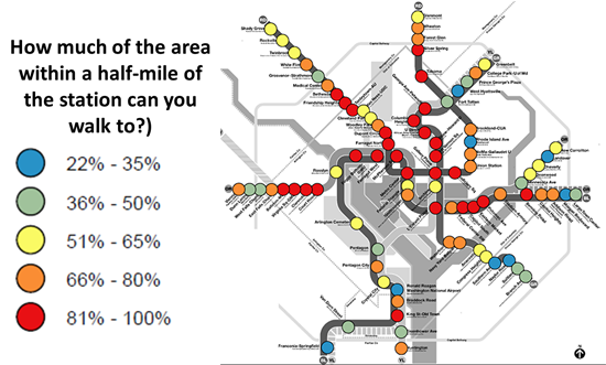
How much of the area within a half-mile of our Metrorail stations can you walk to?
Which Station Areas Should The Region Invest In?
Metro’s Momentum encourages the Authority to identify station areas where additional density or network connectivity is warranted so that we can work with our partner jurisdictions to make the right investments. Metro’s Office of Planning is beginning this effort by developing two approaches to view and prioritize station area investment needs.
(1) Understand the pedestrian network coverage within a half-mile radius of our Metrorail stations: As the map above shows, some of the station areas have excellent coverage – nearly 100% of the area within a half-mile radius is accessible by foot – while others have so many gaps in the network that getting from the station to any type of amenity (housing, retail, office, parks, churches) is virtually impossible.
(2) Annually track how well Metrorail station areas capture household growth as a proportion of general household growth in the Compact: We know that over the past ten to fifteen years, residential and office growth has gravitated towards the areas around Metrorail stations. This shift means that this land generates more for the region than it takes up in its land base. By annually tracking the extent to which Metro continues to be an attractive place for households to locate – and comparing this attractiveness to other parts of the region, Metro establishes a “target market share” of annual growth. Among many other things, this allows us to understand which station areas are adding enough density to have the congestion impacts described in the previous post – and which station areas need planning, zoning, and/or development investments in order to meet the desired levels of density and contribute to the goal of taking cars off the road.
Metro will be reporting the latter in Vital Signs each year, both at the Compact level and at the jurisdictional level. This will make Metro only one of two transit operators in the entire nation that measures its work in part by its impact on surrounding land use changes.
What Does the Data Indicate?
Let’s take a look at the data over the last three years. The Compact area is approximately 1,500 square miles and Metrorail’s transit shed, the area within a half mile of a station, is less than 4 percent of the Compact’s total land area. In 2011-2012, this transit shed captured 18% of household growth and that figure remained steady in 2012-2013. When the transit shed of our busiest Metrobus services is added, there is a slight uptick during the same time periods, going from 49% to 52%, respectively.
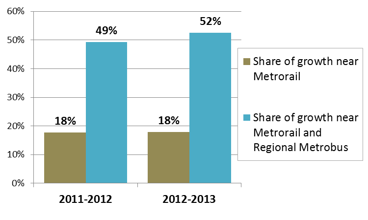
In the past 2 years, we’ve focused 20% of our household growth near Metrorail; 50% near Metrorail and regional Metrobus.
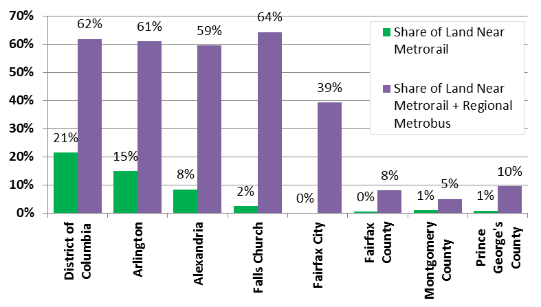
Metrorail and Metrobus cover some jurisdictions more than others.
Of course, some jurisdictions are already “walking the walk”, so to speak. Check out the snapshot below, which shows the extent to which jurisdictions were able to capture or direct household growth towards the Metrorail transit shed over the past three years.
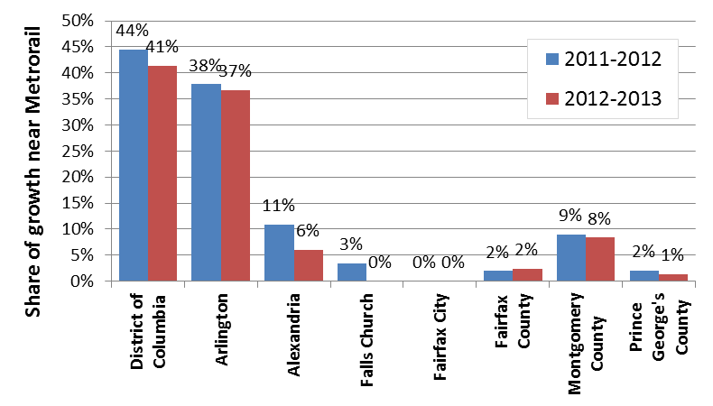
Share of household growth that occurred near Metrorail, since 2011
Example of Recent Transit-Oriented Development Decision

Planned Development Around Largo Town Center Metrorail Station, from the Largo Town Center Preliminary Sector Plan and SMA. Click link for original, PDF.
As I type this blog post, I am joined by 188 community leaders and citizens discussing the future of the newly-announced Regional Medical Center at Largo Town Center in Prince George’s County.
Initiatives like these have the promise to add the type of adjacent development and network connectivity at or near existing Metrorail stations and induce large increases in transit usage and mode share. The result is a less-congested region and one that is more sustainable, all while using infrastructure that we have already paid for. Metro is looking forward to more initiatives like these and believes that walkability and transit-oriented development strategies must be at the heart of our region’s attempt to grapple with its congestion and restore the promise of continued economic growth.
After all, land use is a transportation strategy.
* There are two primary policies at Metro which guide this effort. First, Momentum‘s Strategic Goal #3 is to “Improve Regional Mobility and Connect Communities”. Among the many priority actions supporting this goal is the following: “Aggressively address underutilized capacity by working with jurisdictions as they pursue land-related actions that will result in ridership growth at minimal additional operating cost where Metro excess capacity exists”.

How do you calculate the “how much can you walk to” metric?
I’m wondering why a core station like Smithsonian has <80% accessibility or how Archives is under 65% – they're both at least 1/3 mile from highways, so could it be because of other factors like federal security perimeters or large block size?
I think the walkability is coming in a bit low for DC for two reasons, a lot of areas are walkable off the street grid and stations are so close together some stations might not be fully walkable within a half mile but there is usually another station nearby that might be accessible to that area. Although there are some places like L’enfant that are way below optimal in terms of walkability for their location. Rhode Island and Fort Totten deserve the low scores too, though I except that will change within the next decade or so.