Archive for March, 2014

Solving the Region’s Congestion Woes – One Step at a Time (Part 3 of 3)

March 31st, 2014 2 comments

Making every Metrorail station area walkable could reduce regional congestion without breaking the bank.

This is part three of a three-part series.

In the previous two posts we’ve laid out a case for making all transit stations walkable as quickly as possible.

  1. Increasing walkability and density at station areas has huge impacts on transit mode share and can take tens of thousands of cars of the road every single day.
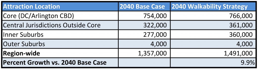
  2. At a regional level, walkable station areas have an equivalent impact on congestion as a quarter trillion dollars in “last mile” infrastructure (see pages 37, 38, 43, 48).

Maximizing the capacity of the existing transit network while intelligently investing in station area connectivity would combat regional congestion just as effectively as trying to “build our way out of the problem”. And unlike many potential interventions, the market actually wants to do this for us.

Perhaps it is time to harness these market forces to make the areas around our transit network walkable and implement this low-cost congestion-busting paradigm. As for where to begin – well, we have a few suggestions…

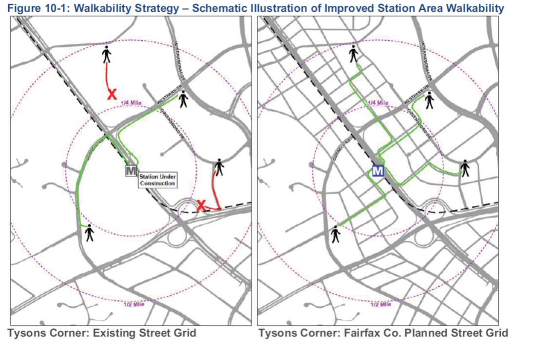
Existing Walkability Near Metrorail Stations

The map below shows the range of existing walkability conditions near the Metrorail network and helps answer the question of how much of a half-mile radius of each station a person can walk to. The higher the percentage, the better the pedestrian network coverage. As shown, many of the station areas are under performing relative to their potential walkability. If walkability = connectivity and connectivity = mode share, then just imagine the impact on the region’s roads if we could focus on taking station areas with low accessibility and invest in some relatively easy, short-term solutions like sidewalks, pedestrian bridges, crosswalks, and smart, transit-oriented development to take maximum advantage of the existing Metrorail system and take tens of thousands of cars off the road each day.

How walkable are our region's Metrorail stations?

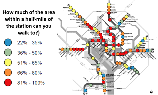
How much of the area within a half-mile of our Metrorail stations can you walk to?

Read more…

Planning for the End of the Driving Boom

March 27th, 2014 2 comments

Americans are driving less and owning fewer cars, which means we have to make different decisions about where to spend scarce transportation resources.

In a fascinating post in the Atlantic Cities, Eric Jaffe doesn’t waste words with assumptions but rather relies on actual data to inform us that America has already reached “peak driving” and that the future of transportation in America is no longer linked to ever-increasing vehicle miles traveled (VMT).

This should come as no surprise, given that VMT has missed forecasted estimates since the early 2000’s. Just check out this handy chart from the U.S. Department of Transportation’s Conditions and Performance Report (PDF) to Congress.

Figure 1. U.S. VMT (in trillions) as tracked by FHWA’s Travel Volume Trends (“Actual”) and as projected by U.S. DOT’s C&P reports (by year reports are dated). Via SSTI. Click image for original: http://www.ssti.us/2013/12/new-travel-demand-projections-are-due-from-u-s-dot-will-they-be-accurate-this-time/


Regional roadway planners are already beginning to embrace this thinking, as the chart from the State Smart Transportation Initiative illustrates in its analysis of MDOT’s transportation plans. These plans not only acknowledge declining VMT, but now omit traffic projections altogether. Read more…

Major changes coming to Metrobus routes 10A, 10B, 10E, and 9E on March 30

March 26th, 2014 2 comments

Last fall we let you know about changes we proposed on the bus routes serving Hunting Point and the Mount Vernon Avenue/Jefferson Davis Highway corridor.  We developed the original proposal based on recommendations that emerged from a comprehensive study conducted on Routes 10A, 10B, and 10E in 2013.  In the weeks leading up to our September public hearings as well as in oral and written testimony given at those hearings we received numerous comments and opinions on the options we presented.  We incorporated that feedback into an adjusted proposal and presented it to Metro’s Board of Directors for approval.

On Sunday, March 30, 2014, Metro will implement these changes that will impact Metrobus routes 9E, 10A, and 10E.  We believe riders will benefit from faster travel times and improved connections between Alexandria, Crystal City and Rosslyn.

What these changes mean for you:

Route 10A riders:
During the a.m. peak period northbound (from Hunting Point) and the p.m. peak period southbound (to Hunting Point), Route 10R will replace 10A service. Route 10R will provide a direct connection between Crystal City and Rosslyn bypassing the Pentagon. Existing 10A passengers traveling to the Pentagon may take a Route 10E bus or transfer to Metrorail at Braddock Road Station. These changes do not impact off-peak, weekend, a.m. peak period southbound (from the Pentagon) or p.m. peak period northbound (to the Pentagon) 10A service. Read more…

Major changes are coming to Metrobus routes 23A and 23C on March 30

March 25th, 2014 Comments off

On Sunday, March 30, 2014, Metro will improve bus service in the Tysons-McLean-Crystal City corridor. The changes, which will affect Metrobus routes 23A and 23C, were part of a series of improvements presented at our public hearings in the fall of 2013 and will provide significantly improved bus service for the majority of riders on these routes.  This restructuring will also allow better coordination between Metrobus, Metrorail and Fairfax Connector bus service once Silver Line service begins.

What these changes mean for you:

Route 23A riders: 
Route 23A will operate between Crystal City and Tysons Corner Center weekdays during non-peak periods and at all times on weekends. During weekday peak periods, new routes 23B and 23T will replace Route 23A service. New Route 23W will replace all service between Tysons Corner Center and Tysons-Westpark Transit Station.

Route 23C riders:
Routes 23B and 23T will replace all 23C service between the intersection of Old Dominion Drive and Chain Bridge Road in McLean and Crystal City. Route 23C service will be discontinued. Alternate service in the McLean and Langley areas is provided by Metrobus Routes 15K and 15L on Chain Bridge Road and Dolley Madison Boulevard. Read more…

New routes, more service, and other changes coming to bus routes in Southeast DC

March 24th, 2014 2 comments

Last fall, Metro presented numerous proposed bus service changes at our public hearings. Many of these proposals impacted bus routes in Southeast DC and we received significant feedback from riders and other concerned citizens.  We heard you, we listened, and we updated or discarded our proposals based on your feedback.  Our original set of proposals included changes to:

What is happening now?

On Sunday, March 30, 2014, Metro will implement major changes on several Metrobus routes in Southeast DC, including the M2, M8, M9, V7, V9, and W4. These changes will improve neighborhood circulation and provide the direct connections to shopping and community services that residents have requested. These changes will also allow Metro to improve service on local high ridership routes. Here is what these changes mean for you: Read more…

Solving the Region’s Congestion Woes – One Step at a Time (Part 2 of 3)

March 24th, 2014 4 comments

Improving pedestrian connectivity takes cars off the road at a formidable clip – rivaling the power of all of the region’s planned roadway additions and “last mile” transit connections.  Cheaply and quickly. 

This post is part two of a three-part series.

The data is finally in, and we now know that walkable station areas result in fewer motorized trips, fewer miles driven, fewer cars owned, and fewer hours spent traveling. And when we improve the pedestrian and bicycle access and connectivity to Metrorail station areas, ridership goes up, putting a major dent in congestion by taking trips off the roadways. Earlier, we discussed what it means to build walkable station areas and research shows the tremendous benefits to the region of making this a priority.

First, our data confirms that when walking access to transit is improved, transit ridership goes up – way up. In the 2040 Regional Transit System Plan (RTSP), we stress tested TPB’s transportation model to improve walkability to the transit network and saw huge increases in transit linked trips.  These trips go up by about 10% region-wide and we get an increase in transit mode share for all regional trips by 0.5%.  That’s over and above the roughly one percent increase in mode share we anticipate occurring as a result of building the entirety of the CLRP, an impact about half that of constructing all of that transit.

Source: Regional Transit System Plan

Source: Regional Transit System Plan

Read more…

Changes are coming on March 30 to Metrobus service in Laurel

March 21st, 2014 Comments off

Effective with Metro’s March 30, 2014 service changes, Metrobus will implement major changes to bus service in Laurel on routes 87, 88, 89 and 89M. During a comprehensive study of the Laurel bus routes, riders expressed a desire for more reliable service that operates later into the evening. These changes will begin to address those issues.

What these changes mean for you:

Route 87 riders:
During weekday morning peak periods, trips leaving Laurel at 5:48, 6:25 and 7:11 a.m. will continue from Greenbelt Station to New Carrollton Station. During weekday afternoon peak periods, three trips to Laurel will begin service at New Carrollton Station and will serve Greenbelt before continuing to Laurel. These three trips are scheduled to depart New Carrollton at 4:05, 4:55 and 6:20. Read more…

What Metro 2025 Means to Virginia

March 20th, 2014 1 comment

Metro 2025 would bring significant benefits to northern Virginia, allowing the region to thrive economically while preserving regional vitality.

Think Metro’s Momentum plan is all about “downtown?” Think again! Our seven Metro 2025 initiatives – from eight-car trains to bus-only lanes will bring dramatic improvements to the quality of life and transportation to northern Virginia.


Benefits Icons_Expansion

Supports Virginia Transit Projects

Virginia is planning big for transit, which is great – but all of the planned projects rely on a robust Metrorail and Metrobus “backbone” to succeed:

  • The Silver Line extends Metrorail by over 20 miles, and will generate tens of thousands of new riders per day when Phase II opens – many of whom will travel into Metrorail’s already congested core.
  • The Columbia Pike Streetcar will transfer 32,000 riders per day to and from Metrorail at Pentagon City – at a point in the system that is already maxxed out.
  • Two other planned busways (Crystal City/Potomac Yard, and Van Dorn/Beauregard) also connect with Metrorail stations.

All major transit projects funded in the CLRP in Northern Virginia depend on the "backbone" of Metrorail and Metrobus.

All major transit projects funded in the CLRP in Northern Virginia depend on the “backbone” of Metrorail and Metrobus.

By ensuring that Metro services can keep pace with congestion and demand, Metro 2025 is critical to making Virginia’s transit projects a success, and critical to helping the region and the state reach its transportation goals. Read more…

What Metro 2025 Means to Maryland

March 18th, 2014 1 comment

Metro 2025 would bring significant benefits to Maryland, supporting its economic growth and ensuring its future vitality.

Metro’s Momentum plan calls for seven Metro 2025 initiatives – from eight-car trains to bus-only lanes, which will bring dramatic improvements to the quality of life and transportation to Maryland.


Benefits Icons_Expansion

Ensures the Success of Maryland Transit Projects

Maryland has great plans for transit.  The Corridor Cities Transitway, the Purple Line, and the Viers Mill Rd Busway are all included in the CLRP with a reasonable expectation for funding, and the Federal Transit Administration announced recently that the Purple Line would receive $100 million in Obama’s latest FY15 budget.  Additionally, Montgomery County is developing plans for a county-wide BRT system.

These projects are worthwhile ventures, but they will always rely on the supporting regional “backbone” of Metrorail and Metrobus to deliver their intended results. At the very least, these three important projects would not connect to each other if not for Metrorail and Metrobus.  And at the very worst, if these projects are built and connect to a system that is already over capacity, they may struggle to live up to their mobility goals.

  • The Corridor Cities Transitway will function as a BRT extension of the Red Line: 1,500 people per peak hour will transfer to Metrorail at Shady Grove by 2030. (For context, about 3,000 riders per peak hour enter Shady Grove in the peak hour today.)
  • The Viers Mill Rd Busway will connect to three Metrorail stations. The current Metrobus Q-Line, a part of the Priority Corridor Network (PCN), currently provides over 8,800 trips per day, including approximately 800 transfers a day to Metrorail.
  • 10,000 Purple Line riders per day will come to and from Metrorail, where the Purple Line connects to the Red, Green, and Orange lines. Many of these passengers will further strain the over-congested lines of the rail network.

x

Funded Maryland transit projects, in the CLRP.

By ensuring that Metro services can keep pace with congestion and demand, Metro 2025 is critical to making Maryland’s transit projects a success, and critical to helping the region and the state reach its transportation goals.


Benefits Icons_Support Growth

Supports Maryland’s Growth Prospects

Maryland’s population in the Compact region is growing steadily and projected to continue growing. This growth is crucial to the economy of the state – 40% of Maryland’s state economic output came from the Washington region’s suburbs in 2012.  With that growth comes significant transportation needs, and Metro 2025 is critical to meeting that growth.

When congestion goes up, job growth goes down, and if Maryland wants to see growth potential turn into actual jobs, it needs to tame congestion.  Simply, Maryland needs the mobility that Metro 2025 would deliver: 8-car trains capable of moving the equivalent of 16-18 lanes of highways (in each direction) and connect Maryland to other regional job centers, superior bus service that can create much-needed east-west connections that bypass snarling congestion, and more. Read more…

Solving the Region’s Congestion Woes – One Step at a Time

March 17th, 2014 1 comment

One solution to the region’s crippling congestion could be right under our feet – literally.

This post is part one of a three-part series.

Illustration of possible walkability improvements that could occur in/around Tysons Corner. From Regional Transit System Plan


The region is abuzz with $220B of planned new transportation investments – the Purple Line, HOT Lanes, new streetcar lines, and additional roadways. Though there is not one dollar currently pledged to add capacity to Metro, these other investments may help the region chart a course away from leading the country in congestion (pdf).

However, for a quarter trillion dollars, one would expect that collectively these projects would have significant impacts on the region’s congestion. While there are some benefits – vehicle miles traveled (VMT) per capita are expected to decline and  transit mode share may increase by one percent – overall increases in VMT are expected to outpace road construction, leading to a 38% increase in the number of lane miles of congestion (pdf). But is there another way to get more bang for our buck?

Make station areas walkable. Every one of them. Now.

Read more…