The Los Angeles area is aggressively leveraging billions in local tax dollars to transform the region into a more vibrant place with a variety of transportation options.
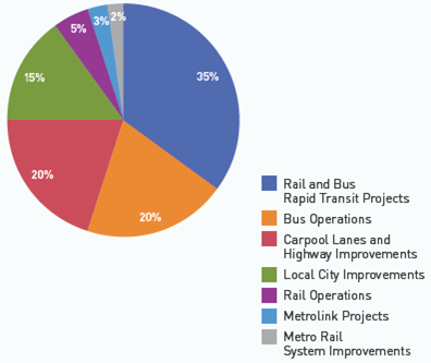
Measure R Spending Breakdown
The conventional wisdom today is that the days of big expensive transportation investments are over. Los Angeles apparently didn’t get the memo. The main transportation planning and development agency in the LA area, the Los Angeles County Metropolitan Transportation Authority (LA Metro), is currently leading the development of the nation’s largest regional transportation expansion program. The program of projects, Measure R, was overwhelmingly approved by more than two-thirds of LA county voters in 2008, and raised the local sales tax one-half cent. The half-cent sales tax is expected to raise $40 billion over 30 years (including an estimated $590 million in 2012) to provide the lion’s share of funding for Measure R transportation projects around the region, helping Angelenos avoid some of the area’s legendary traffic congestion. Not satisfied with the already impressive pace of expansion, LA Metro’s Board of Directors is now exploring a second ballot measure that could come as early as 2016.
Measure R includes an impressive array of transit projects, including the Orange Line Bus Rapid Transit extension, Expo and Regional Connector light rail lines, and the Westside Subway, among others. Below is a map of the transit projects fully or partially funded by Measure R (click on the map below for the interactive version):
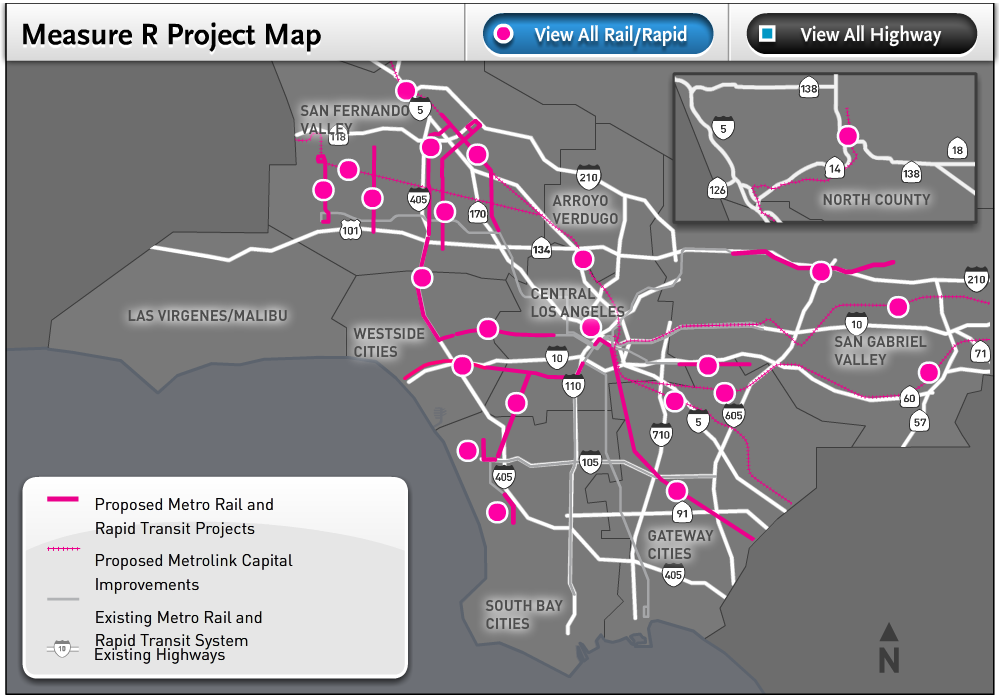
Measure R Transit Map (source: LA Metro)
Read more…

Paya Lebar MRT Station Map (click & zoom for detail)

Travel Times Between Stations
While waiting for a Metro train one day in Singapore, I noticed their rail map diagram had a big white space and then the rest of the map. Upon closer inspection the ‘white’ part was actually a grayed out part of the rail map showing the route the train had already covered. Having that information is very useful, particularly for a traveler unfamiliar with the system. One knows if they are starting at this particular station (Paya Lebar), what their options might be if he/she actually wanted to go in the opposite direction. This information gives the rider a helpful reference point in relationship to the rest of the system. Also upon closer inspection I saw that the map gave expected travel times between stations. How great is that?
I was invited to present a wide variety of data visualizations featured on the blog at a recent meeting of transportation techies.
I had the honor of being invited to present at the 2nd meeting of the Transportation Techies Meetup group, Metro Hack Night on January 2, 2014. I used this opportunity to illustrate some of the data visualizations I’ve developed using Metro data and talk a bit about the technology behind them.
The first was the the
visualization of 9 years worth of rail ridership data. This visualization was created in
D3 (“data driven documents”) using code originally developed by “
mbostock” posted on the D3 examples page. D3 is a javascript library that allows the creation of really
powerful and interactive visualizations. The downside of D3, as I noted, is that the code itself can be confusing and hard to follow. So much of learning a new coding language is looking at what others have done and learning from it. D3’s simplified notation makes it really hard for me to follow. (
NOTE: this visualization has recently been updated to include daily Metrorail ridership for all of 2013.)
The second was the visualization of one day of Metrorail station activity. This video was created using Processing, a Java-based visualization tool that takes care of a lot of the coding “grunt work” and allows a programmer to focus on the data and the visualization. I really enjoy Java so I took the opportunity this project provided to add a few flourishes such as a clock face and “sunrise” and “sunset.” Read more…
In anticipation of the Silver Line, nearly twenty development projects, with an estimated value of more than $18 billion, are underway near the Metrorail stations, helping attract riders and generating valuable benefits for Fairfax County.
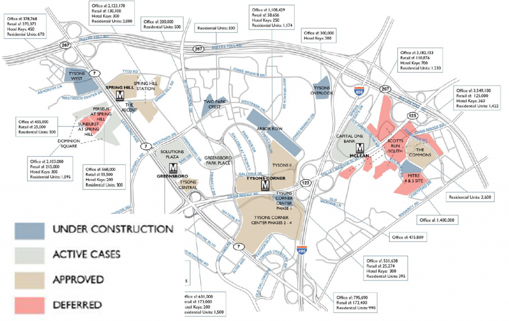
Ahead of the Silver Line, many development projects are underway around the new stations. Image from Cushman and Wakefield, click link at left for full report.
In a new report, the real estate firm Cushman & Wakefield documented twenty real estate development projects “in the pipeline” near the five new Silver Line stations. Some are under construction now, others are in the approvals process, and a few are on hold, but together they total:
- Over 20 million sq. ft. of new office space, which would increase the total office space in the Tysons area by 40%.
- Over 2 million sq. ft. of new retail space. That’s more than twice the size of the Tysons Galleria mall.
- 17,800 new residential units, or more than double the current population of the Tysons area.
- 9,300 hotel rooms
Metro estimates that these projects are valued at more than $18 billion, and will generate millions per year in tax revenue for Fairfax County (estimated using industry-standard construction costs). Some of this tax revenue will be captured by special tax districts in the Tysons and Silver Line areas. In 2011, we estimated that Fairfax County received around $30 million in tax revenues from properties within a half-mile of its five existing non-Silver stations.
The development brings great benefits to Fairfax County and will encourage riders to use the Silver Line, but there remains a strong need to improve the walking and biking environment near the new stations. Pedestrian and bicycle access will be key to meeting our ridership goals for the new Metrorail line, but walking and bicycling conditions remain challenging in the area.
Metro is investing in a series of bus stop improvements across the region that will improve the rider experience and fully comply with the Americans with Disabilities Act (ADA).
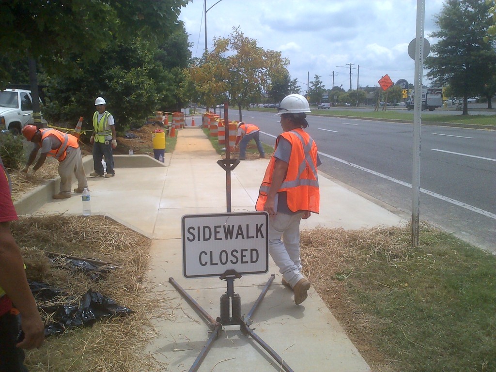
Construction of the improvements for the stop on Branch Avenue and Silver Hill Road
Metro is investing in bus stop improvements to make bus riding easier for everyone, but especially for persons with disabilities. Improvements have been completed along two routes; the J4 route (College Park- Bethesda MetroExtra) and the P12 (Eastover-Addison Road Station). Addtional work was also done in the City of Greenbelt. These stops were selected as a part of the regional TIGER grant bus priority initiative designed to improve bus speeds and customer facilities along high demand corridors throughout the region.
To meet ADA requirements, bus stops must have four attributes:
• The pedestrian (landing) pad must have a firm, stable surface that is at least 5’ by 8’ (located at front door stopping location).
• The pedestrian pad must connect to the curb.
• The sidewalk must connect to the pad.
• The sidewalk must have a pair of curb ramps (leading to the bus stop).
At some locations, Metro was able to provide additional improvements, such as shelters, and in-street concrete pads, which are better able to withstand the heat and weight of a bus than regular asphalt. The specific improvements are described
Read more…
I was recently in Singapore for vacation and while I was there I used their delightfully clean and efficient rail system (more on that later). While walking through the stations, I spotted several movie posters, which actually happened to be posters for YouTube-based public information message ‘movies’. The movies are put out by the Land Transport Authority, which is a part of the government that does the planning for their transit systems.

‘May I Have a Seat Please?’

‘Can You Move in Please?’
Can you move in please? leaves viewers with two messages: 1. move to the back of the bus so that everyone can get on, and 2. take off your backpack or move any bags you may have out of the way. Some of the movie is lost in translation I think culturally speaking but still, you get the point.
Excuse me, May I have a seat please? is about exactly what the title suggests. This movie especially rings true in this day and age as a lot of commuters have their noses buried in their books and cell phones (even more prevalent in Singapore – a lot of people walking in stations and outside while watching movies!!).
The courtesy issues that Singapore is tackling rings true here in DC too, as well as any city that has transit.
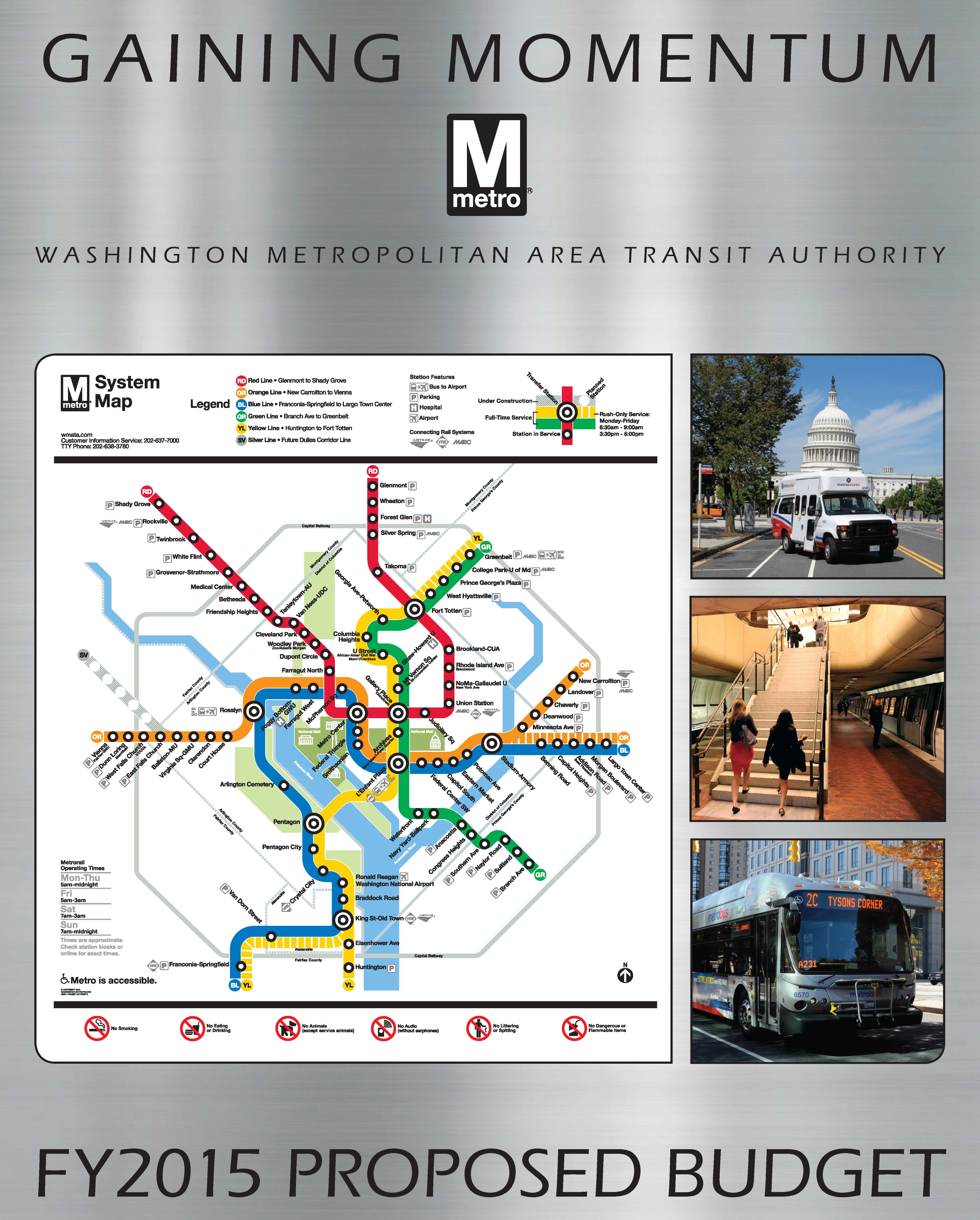
We want to hear from you! Interested  in the FY2015 budget? Answer our survey or participate in an upcoming public meeting. Want to talk more long-term strategy? Connect on MindMixer.
We are seeking feedback from riders and offering multiple ways to comment on the proposed FY2015 budget and fare changes, as well as Metro’s Capital Improvement Program. You can participate in any or all of the following:
- Survey: The survey includes questions about the fare changes, costs, and the benefits you will see going forward. The survey is open until 5 p.m. on February 11, 2014.
- Public Hearings: The six public hearings will provide an opportunity for riders to give formal testimony on the docket of proposed budget actions.
Looking to get into the weeds and talk about some long(er)-term opportunities? We have started a new discussion on MindMixer to gather your ideas and thoughts about priorities and potential future changes to the balance of funding between riders and local government, continuing to allow fares to be paid in cash on Metrobus, parking, new fare options, and priorities for a down payment on Metro2025 initiatives.
Read more…
Ten years ago I moved to Tokyo for work. Unfortunately, my Japanese language skills were non-existent, so I spent much of those early months perpetually lost on Tokyo’s streets. But underground it was a different story. If you’ve ever been, you know that many of the central Tokyo stations are massive – multiple exits, mezzanines, pedestrian tunnels, and tons and tons of people. However, Tokyo Metro, the JR East Lines and the private rail lines that together create the city’s rail network have a good wayfinding system provided in Japanese and English that make it fairly easy to get around underground.
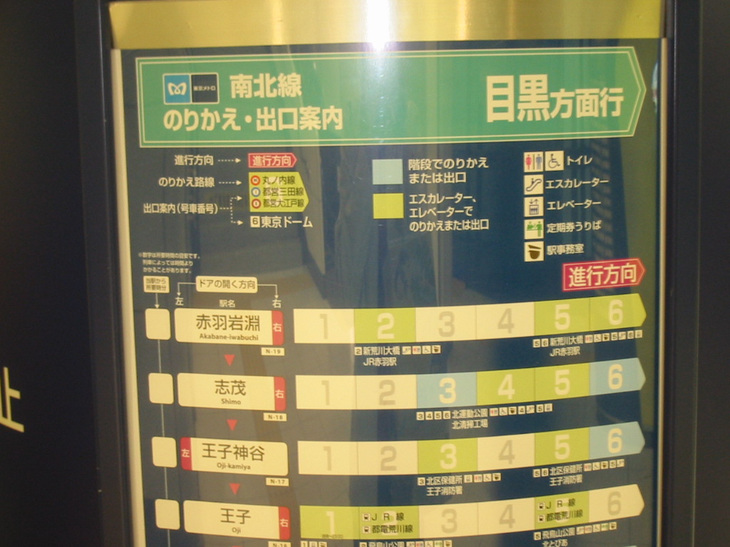
Which car should you use?
Read more…


Recent Comments