Archive for November, 2013

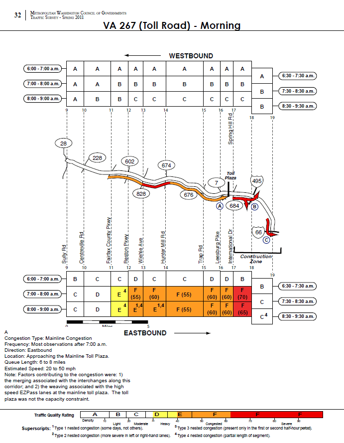
New Station Mezzanine Lights Show the Way

November 21st, 2013 9 comments

New Station Lighting at Judiciary Square

New Station Lighting at Judiciary Square.  Click image for larger version.

Pilot upgrades using energy-efficient lighting at three stations have been a success, so Metro is planning to ramp up the effort to 41 more stations by 2015.

Metro recently completed retrofitting the mezzanine-level lights at Judiciary Square, Gallery Place, Bethesda, Smithsonian and Metro Center. Through careful fixture selection, the new fixtures provide a higher quality of light with an improved Color Rendering Index (CRI) thereby improving both lighting levels and overall visibility. Significantly, the new lighting design offers better light levels without compromising the integrity of the original lighting design and station aesthetic. The retrofits also provide significant lifecycle cost savings for Metro through reduced energy consumption and maintenance requirements.

Following these successes, Metro General Manager/CEO Richard Sarles today that it plans to upgrade mezzanine lighting at the 41 remaining underground Metrorail stations by 2015.  In addition to the five already completed stations, one station, L’Enfant Plaza is currently under construction. Read more…

How Will The Silver Line Impact The Region’s Traffic Hotspots?

November 19th, 2013 3 comments

The Silver Line will relieve traffic congestion on the Dulles Toll Road and I-66 when it opens in 2014.

This post is a continuation of our series that answers questions about the new Silver Line.

It’s no secret that the Washington region has some of the worst traffic in the country.  Listeners to “drive time” radio are bombarded with rapid-fire traffic reports noting congestion on major regional highways, often caused by “nothing but volume”.  This expression means there is no traffic accident, weather incident or excessive sunshine slowing cars down.   Instead, too many cars are trying to squeeze into too few lanes at critical interchanges, resulting in traffic queues that can extend for miles and miles.

Not surprisingly, the highways along the Silver Line corridor are some of the region’s most congested. The merging of I-66 and the Dulles Toll Road was ranked fourth worst congested location (PDF) in the MWCOG Spring 2011 Traffic Survey.  The survey showed the toll road has three major congestion spots in the AM Peak:  the toll plaza, the interchange with the Capital Beltway and the merger with I-66.  In all three cases, the recurring congestion was caused by vehicles weaving and merging.

Surveyed morning traffic conditions on the Dulles Toll Road, from the MWCOG 2011 Traffic Survey. Image links to PDF report.

According to the MWCOG report, the speed in the traffic queue is between 20 and 50 MPH.  This would result in between 2 and 12 minutes of delay per vehicle joining the back of the queue heading to the toll plaza. Assuming a duration of 2 hours for the queue, average vehicle occupancy of 1.1 and 1,900 vehicles per lane per mile, this results in between 560 and 3,300 person-hours of delay per day, up to 840,000 person hours per year. Read more…

Pedestrian Paths and Bike Stairchannel Complete at Glenmont

November 15th, 2013 9 comments

As we continue to improve pedestrian and bicycle access to Metrorail,  Metro has recently completed several  improvements on the east side of Glenmont station.

Walking and bicycling are key access strategies for Metrorail, as Metro seeks to grow ridership in sustainable and cost-effective ways. As our studies have shown, accommodating new riders at our current access modal shares would be quite costly to the region.  At Glenmont station, around 12% of riders in the morning arrive on foot or by bike, but there may be growth potential. Nearly 80 customers per day live within 1 mile of the station but currently park.  Over 550 customers, or a third of all parking customers, live within 3 miles of the station but currently park.

To make Glenmont station more attractive and safe for pedestrians and bicycles, Metro’s Parking Office has constructed new paved pathways connecting the station to the intersection of Layhill Road and Glenallan Avenue, replacing a dirt path. Metro has completed this work as part of the Bicycle and Pedestrian Capital Improvement Program.

Glenmont NE Path 3Glenmont NE Path 2

Read more…

H and I Streets Bus Improvements Study — Final Technical Report Released

November 14th, 2013 6 comments

Metro has released the final technical report of the H and I Streets Bus Improvements Study, making a compelling case for traffic management improvements and bus lane alternatives in the region’s most heavily traveled bus corridor.

Congestion on I Street caused by bottleneck at 17th Street, creating long queues backing up to 15th Street.

Congestion on I Street caused by bottleneck at 17th Street, creating long queues backing up to 15th Street.

DC’s downtown core is a vibrant community, with 380,000 jobs today and significant residential and retail development in the coming decade. While growth will transform the core and create opportunities, it is likely to increase the burden on the transportation network that is already strained by the closure of Pennsylvania Ave.

Today, all users—drivers, bus passengers, pedestrians and bicyclists—experience congestion during peak periods.  Besides high-volume traffic in the corridor, the constant friction among buses, vehicles and delivery trucks further aggravates travel experience.  For bus passengers, the current corridor congestion severely affects travel time and service reliability—a short bus ride on I Street from 13th St to 19th St could take more than 10-15 minutes during rush hours.

Metro and DDOT collectively launched the H and I Streets Bus Improvements Study last year to explore bus improvements on H and I Streets NW in the downtown core, the region’s most heavily traveled and most productive bus corridor.  The study investigated traffic management improvements and bus-only lane options with the objective of providing reliable and efficient bus service and alleviating Metrorail core congestion through innovative surface transit improvements.

The technical report is available for download (PDF) and posted on Metro’s Planning and Development webpage.

Four bus improvement options developed for analysis, as described and illustrated below: Read more…

Twenty-Plus Reasons for Off-Board Fare Collection

November 12th, 2013 4 comments


New Orleans Streetcar Off-Board Payment

A crowd of tourists wait to board the St. Charles Streetcar.

 A few years ago I visited New Orleans and took the St. Charles Streetcar from downtown to the terminus by Jefferson Ave.  The stop where my friends and I boarded had a ticket vending machine, which we used.  The stop pictured, however, did not.  I shared this picture with friends, entitled “Twenty-Plus Reasons For Off-Board Fare Payment.”

Metro is currently investigating options for off-board SmarTrip loading.

Metro Evaluating Options for Off-Board SmarTrip Loading

November 6th, 2013 20 comments

Metro seeks to reduce delays to Metrobus caused by on-board SmarTrip card loading by installing off-board SmarTrip® Recharge Stations at key locations across the region.

Metro has been quite successful at increasing the use of SmarTrip® card usage on both bus and rail.  As noted in a previous post, many initiatives — including surcharges for paying cash — have been successful at raising the the SmarTrip® use rate to about 90% on both Metrorail and Metrobus.  As many readers have noted, many Metrobus customers load small amounts of cash — enough for one or two trips — onto their SmarTrip card in order to avoid the surcharge.  This on-board load transaction can take between five and 30 seconds and, on average, one out of every 14 trips on Metrobus involves a small value load. On some routes it’s as frequent as one out of every seven.  This behavior results in longer dwell times, slower rides, and less efficient operations of Metrobus.

One possible solution is to increase the opportunities for loading value onto SmarTrip cards before the customer boards.  While SmarTrip cards can be reloaded online, at Metrorail stations and at a variety of retail outlets around the region, the frequency of on-board loading indicates the need for additional, convenient opportunities to add value to SmarTrip cards.

animated-example

Example of potential SmarTrip Reload Station size and location. Image updates every 5 seconds. Click image for larger version.


Metro is seeking to meet this need by developing and deploying SmarTrip Recharge Stations (SRS) at selected bus stops around the region.  In addition to facilitating the loading of fares and passes to SmarTrip cards and working with Metro’s current back-end systems, the requirements for these recharging stations include: Read more…

Categories: Fares and Service Tags: , ,

Metrobus Carries the Load on 16th Street

November 4th, 2013 7 comments

During the morning rush hour, Metrobus carries 50% of all of the people traveling on 16th Street NW towards downtown DC, despite using just 3% of the vehicles. However, it still gets stuck in traffic.

It will come as no surprise to regular riders of the Metrobus S1,2,4 (PDF), or MetroExtra S9 (PDF), but ridership has grown tremendously in recent years on 16th Street, from just over 16,000 riders per weekday in 2008 to about 20,500 this year.  To keep pace, Metro has added lots of new service, most notably the S9 limited stop service in 2009.

In fact, Metro has added so much rush hour service on lower 16th Street that buses headed towards downtown DC now operate more frequently than any transit service in the region, including Metrorail, with buses arriving an average of nearly every 90 seconds.


16th Street Throughput Chart

Read more…