
How Do Metrorail Riders Get to Their Station in the Morning?
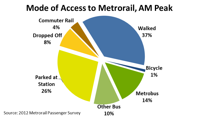
 Two-thirds of Metrorail riders take transit, walk, or bike to Metrorail for their morning commute.
Every morning, thousands of people walk through the faregates and into Metrorail. Did you ever wonder how they get to their station? Our 2012 Metrorail Passenger Survey tells us the answer to this question, for the morning rush:
- More than a third (38%) of Metrorail riders get to the station in the morning by walking or biking.
- Another quarter arrive by bus – Metrobus, as well as other bus operators in the region.
- Another third arrive by car – most by parking at or near the station, but some by getting dropped off.
- Finally, about 4% of riders arrive via commuter rail – mostly at Union Station.
Of the 25,000 or so daily riders who access rail by “Other Bus,” the top three contributors are Fairfax Connector (6,700), Montgomery County’s RideOn (5,700), and private shuttles (4,900). Of those who parked at their station, one-third were driving from less three miles away. Carpooling to Metrorail is very low – we estimate average vehicle occupancy at 1.03 passengers per parked car.
The map below shows how the answer to “How Did They Get to the Station?” varies dramatically station to station. (For the sake of legibility on this map, I’ve simplified the access modes into 4 groups).
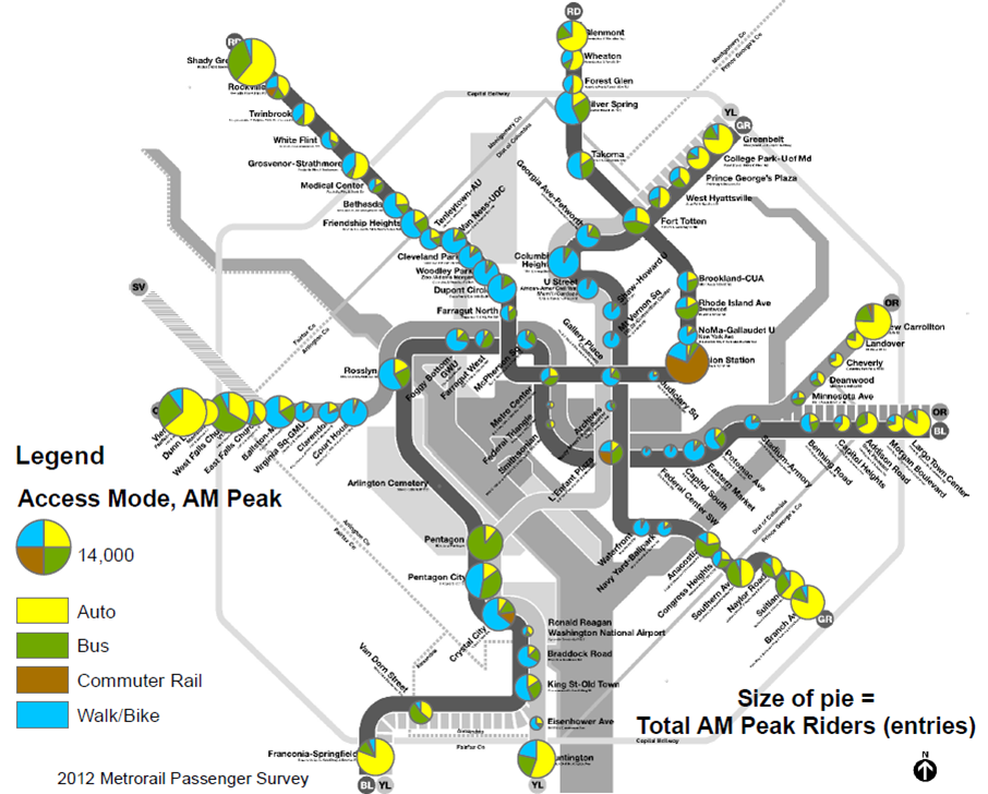
How do Metrorail riders get to their station in the morning? Mode of Access by Station of Origin, May 2012 (click for larger)
A few observations jump out from this:
- Even at stations dominated by parking infrastructure, there is still significant bus access (e.g., Shady Grove, New Carrollton)
- Many stations in neighborhoods in D.C. and Arlington are nearly exclusively walk-access: Court House, Cleveland Park, Woodley Park, Columbia Heights, U Street, Shaw, Mt. Vernon Square, Capitol South, and Eastern Market.
- Bus is the dominant mode of access at West Falls Church, Pentagon, Anacostia, Van Dorn Street, Fort Totten, and Rhode Island Avenue
- Some passengers appear to park at non-Metro parking facilities, since we detect parking access at stations where no Metro-owned facility exists (e.g., Silver Spring)
- There is some noise in the station-level data, since some anomalies appear (e.g., parking access at Metro Center)
What do you see in these data? Do any of these findings suggest anything for walk and bike access? Does anything surprise you here?

People arriving by car at Metro Center and other downtown stations may be passengers with someone who works (and parks) nearby, then board the train to their own job. Given the small number of downtown boardings in the morning rush, it wouldn’t take many. Save fare by carpooling (or slugging) and pay to park only one car.
Car access downtown may be people who drive to work and then take Metro to business appointments.
Why not question on the distance they are from the metrostation ? That would provide insight to where there should be more bus routes, lines or if some routes should be reroute to serve areas with larger populations going to nearby stations.